Báo cáo " An assessment of healthcare system accessibility of local communities in Yen Chau District, Son La Province " pot
Bạn đang xem bản rút gọn của tài liệu. Xem và tải ngay bản đầy đủ của tài liệu tại đây (573.26 KB, 8 trang )
VNUJournalofScience,EarthSciences23(2007)265‐272
265
Anassessmentofhealthcaresystemaccessibilityoflocal
communitiesinYenChauDistrict,SonLaProvince
TranAnhTuan
1,
*,TranVanTuan
1
,LeTuanAn
2
,HoangThanhTung
1
1
CollegeofScience,VNU
2
CentreforEnvironmentalStudies,AllianceofVietnamCooperative
Received10October2007;receivedinrevisedform28November2007
Abstract.SonLaHydroelectricProjecthasdesignedtheplantwiththecapacityof2400MW.Itwill
provideelectricityfornotonlythenorthwestregionbutalsofortheotherregionsofVietnam.The
projectwasapprovedbytheVietnam
NationalAssemblyonDecember16
th
,2002,indetail:SonLa
Hydroelectric Plant will be constructed mainly in Son La and Lai Chau provinces. It has water
reservoirof16billionm3.Therefore,thereare13,656householdsthathavetoresettleinnewplaces.
Healthcarefacilityisoneoftheveryimportantpublicservicesforlocal
communities,especiallyin
thecaseofmountainousdistrictasYenChau,SonLaProvince.BasedontheAccessModextension
of ArcView software, we evaluated the mobility of local people as well as the capacities of
healthcaresysteminthestudyarea.Theresultsofthestudyareshowingthat:there
isonly77%of
total population who can access the healthcare system in Yen Chau District. It means that the
qualityas wellas thecapacityof healthcare systemdid notmeet the requirement of local people.
On the other hand, accessibility is very useful method for assessing the quality of
infrastructure
systemin rural area. It providedtheimportant information of the realconditionofpublic service
systemforlocalplannersandmanagers.
Keywords:SonLaHydroelectricproject;Accessibility;Resettlement;Healthcarefacility;AccessMod.
1.Introduction
*
Son La Hydroelectric Project has designed
theplant with the capacity of 2400MW.It will
provide electricity for not only the northwest
region but also for the other regions of
Vietnam. The project was approved by the
Vietnam National Assembly on December 16
th
,
2002, indetail: Son La Hydroelectric Plant will
be constructed mainlyin Son Laand Lai Chau
_______
*Correspondingauthor.Tel.:84‐4‐6625584.
E‐mail:
provinces. It has water re servoir of 16 billion
m
3
. Therefore,there are 13,656households that
have to resettle in new places. There are three
main methods for resettlement, such as: i) Roll
up resettlement (in the other name as vertical
resettlement).Itmeansthatthelocalpeoplewill
move to higher position at the same site, it
accounts for
20.1% of total people. ii) Mixing
resettlement. It will move the local people to
newplaces,wherethereis existingsettlements.
It takes 14 .5% of total people. iii) The final
methodforresettlementisthatthegovernment
willconstructsomenewsettlementsitesforlocal
TranAnhTuanetal/VNUJournalofScience,EarthSciences23(2007)265‐272
266
people.Itaccountsfor65.4%oftotalpeople.
According to the Project of Resettlement,
thereare10districtsofSonLaProvince,which
willreceivethepeople,including83communes
and 218 resettlement sites. Yen Chau District,
one of the districts of Son La Province, has
suitableconditionsforresettlement
activitiesof
Son La Hydroelectric Project. In order to
resettle and rebuild the economic structure of
the district, there are 16 resettlement sites in 7
communes are designed to receive the people
with 750 households. Each household can get
1.0‐1.5ha of agricultural land and 2.0‐2.5 ha of
forestry
land.
In fact, the resettlement activities in Yen
Chau District are facing some difficulties, such
as: 1) there are some resettlement sites, which
are not suitable in terms of natural and socio‐
economic conditions; 2) in such resettlement
sites, there areʺnative local peopleʺ, who are
living there along
time. Therefore, there are
someconflictsbetweentheʺoldpeopleʺandthe
ʺnew immigrantsʺ; 3) the quality of
infrastructure system in Yen Chau District is
notgoodanditdidnotmeettherequirementsof
localpeople.Suchproblemsledtheresettlement
activities in the district as well as
in Son La
Provinceareunsuccessfulasitsdesignation.
Accessibilityisa usefulresearch methodin
ordertoevaluatetheconditionofinfrastructure
system in rural areas. The advantages of the
methodare:i) providinginformationaboutthe
quality of public services in specific region; ii)
identifying the regions which local
people can
notaccessthepublicservices;andiii)providing
the necessary information for local planners
andmanagers.Therefore,theycanfindtheway
to improve such services as well as
infrastructuresystem.
The ultimate objectives of the paper are the
followings: firstly, to analyze the characteristics
of the study
area, Yen Chau District, in both
naturalandsocio‐economicconditions;secondly,
toevaluatetheimpactsofresettlementactivities
of the Son La Hydroelectric Project; thirdly, to
analyze the healthcare system accessibility of
localcommunitiesinthestudyarea.
2.Studyareaandresearchmethods
2.1.Studyarea
Yen Chau District
is located in the
southwestregionofSonLaProvince.Itsituated
at 21
o
07’‐21
o
14’N and 104
o
10’‐104
o
14’E between
SonLa andMoc Chau highland. The total area
of Yen Chau District is 85,775 ha. The district
has 14 communes and 1 town. In 2004, Yen
Chau’s population is 63,213 persons. In which,
there are 80.8% of minorities, such as Thai,
H’mong people. Agriculturallandaccounts for
76.13%,
non‐agricultural land is 20.38% and
non‐usedlandis3.49%oftotalarea.Ingeneral,
socio‐economic condition is not good as
comparingwithotherdistricts.Thelocalpeople
get mainly benefit from agricultural activities.
All of communes and town have healthcare
infirmaries as well as post offices and
so on.
Nevertheless,theircapacityisnotgoodenough
fortheneedoflocalpeople.
2.2.Database
The study used both kinds of data: spatial
andnon‐spatial.
The spatial datainclude some digitalmaps
of the district, such as: land use map in 2005,
scale 1:25,000; map of existing forest
in 2001,
scale 1:25,000; topographic map in 2000, scale
1:25,000.
The non‐spatial data include development
reports of Yen Chau District in 2000 to 2005as
well as other related documents: reports of
healthcare system (number of healthcare sites
and their distribution); reports of existing
populationconditions,
2.3.Researchmethods
Beside the traditional methods used in
TranAnhTuanetal/VNUJournalofScience,EarthSciences23(2007)265‐272
267
geographicalresearch,suchas:fieldwork,desk
study, statistical analysis, the study has
applied the accessibility method as the new
quantitativeandcoremethod.
Accessibilityisthebroadconceptandithas
a wide range of applications, in particular:
urban studies (housing planning, social
facilities planning and re‐improvement [8];
public space planning [1]; market analysis [6];
rural studies (concepts and methodology of
ruralaccessibility[2,4,7];povertyandfood[5];
ruralaccessibility[2,7]).
In general, accessibility is known as: “the
amountofeffortforapersontoreachadestination”
or “the number of activities which
can be reached
fromacertainlocation”[7].Anaccessiblelocation
isconsideredasthesite whentheeffortsto get
there is acceptable to the target groups (local
communities). Therefore, the concepts and the
uses of accessibility are close related to the
transportation system (length and quality, ),
origins (local
settlements) and destinations
(publicservices).
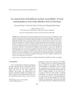
Accordin g to Moseley, M.J., [7], there are
threecom ponent sofaccessibility,including:
‐People,whoislivinginthestudyarea;
‐ Public services, which meet the need of
localpeople;
‐ Transportation system or communication
system play the role in order to connect local
peopleto
publicservices.
The size and structure of population are
affectedonthepossibilityofpublicservice,when
local people will identify the need of public
servicesduringtheirlifeintheparticularperiod.
Theconnectionsbetweenthreecompon entsshow
thetravelcost andtheeffortsinorderto travel
from
origins (their settlements) to destinations
(publicservices).Thepublicservicescomponent
reflects the distribution of destinations and
theirqualityinthestudyarea(Fig.1).
3.Healthcaresystemaccessibility
3.1.Dataprocessing
Based on the primary data as above‐
mentioned, we created three important maps
for analysisprocess, including: Map of
Origins
(distribution of local settlements), Map of
Destinations (distribution of healthcare sites),
and Map of Transportation System
(distribution and quality of transportation
network).Allofthethreemapsarepresentedin
rasterdataformat.
In order to create three maps, we used the
AccessMod, the extension for ArcView
softwareversion
3.2.AccessModisamoduleof
World Health Organization (WHO). It is free
foracademicpurposes.Theextensionusesboth
vector and raster data. The analysis tool for
finalpurposeisusingdatainrasterformat.
3.1.1.Creatingthemapoforigins
According to the data interpolation in
AccessMod,mapof
originscontaininformation
of population in each settlement. It uses the
Fig.1.Therelationshipbetweenthreemaincomponentsofaccessibility(source:Moseley[7]).
Localpeople
(Origins)
‐Preferences
‐Gender,Ages
‐Affordability
‐Carownership
Transportation
network
‐Price
‐Convenience
‐Speed
‐Congestion
PublicServices
(Destinations)
‐Location
‐Type
‐Attractiveness
TranAnhTuanetal/VNUJournalofScience,EarthSciences23(2007)265‐272
268
grid system to interpolate the population of
settlement.Itdivideseachoriginintocells.Each
cell contains a specific number of local people.
Wecalculatedthepopulationofeachsettlement
asthefollowing:
S
P
C
400×
=
,
where:C is the value of each cell; P is the
populationofeachcommune;andSisthetotal
areaofsettlement.
According to the Regulation of the
Government and the results of local people
questionnaires processing, each household in
averageoccupiesanareaof400m
2
,wedefined
the size of a cell is 20x20 m. From the map of
settlements (origins), which are in vector
format,werasterizedthismaptorasterformat.
TheresultisshowedinFig.2.
3.1.2.Creatingthemapoftraveltime
Travel time is known as the necessary and
minimum time for people in order to move
from origin to destination. In fact, the travel
timeiscalculatedasthetotaltimetopassallof
relief units from origin to destination (river,
stream, hill, mountain, ) with the specific
speedofeachtypeoftransportation(goonfoot,
bike,
motorbike,car, ).
Fig.2.ThemapoforiginswiththeirpopulationdatainYenChauDistrict.
TranAnhTuanetal/VNUJournalofScience,EarthSciences23(2007)265‐272
269
Mapoftraveltimeistheresultofoverlaying
all layers with the specific attribute such as
speedoftransportationmethodsthroughoutall
ofreliefunitsinthestudyarea.Inthisstep,we
useddigitalelevationmodel(DEM)asthemain
information source to calculate the time to
travel
throughallofreliefunits.
According to the questionnaires for local
people as well as other related documents, the
average speed of some main transportation
typesareshowninTable1.
In the condition of Yen Chau District, we
evaluated the average speed of transportation
types throughout the relief unit,
which based
ontheDEM.AccordingtotheTobler’sformula,
this showed the relation between slope and
othertopographicconditions.
Table1.Averagespeedinthespecificlandusetype.
Landusetype Averagespeed
National 45km/h
Provincal 30km/h
Distric 15km/h
Road
Commune 10km/h
River,stream 0,06km/h
Agriculturalland 6km/h
Forest 3km/h
3.1.3.Thedistributionofdestination
In the study, destinations are healthcare
facilities, including infirmaries and district
hospital. There are two important attributes in
this step: capacity of healthcare site and
maximumthresholdoftraveltime.
Thecapacityofhealthcaresiteisdefinedas
the number of local people is served by
the
particularhealthcaresite.AccordingtoDoherty
[4], the capacity of healthcare site is calculated
bythefollowingformula:
opy
d
PP
PDHw
C
/
××
=
,
inwhich:
C :capacityofinfirmary;
Hw:numberofmedicalofficer;
D
:numberofworkingday;
d
P :numberofaveragepatient;
y
P :totalpatientinayear;
op
P :populationofcommune;
andforahospital:
tPP
DRB
C
op
b
×
×
×
=
)/(
inwhich:
C :capacityoflocalhospital;
B
:numberofhospitalbed;
b
R :p roport ionofusinghospit albed(%);
D
:numberofworkingday;
P
:totalpatientinayear;
op
P :populationofthedistrict;
t :averagetimefortreatment.
Maximumtraveltimeisdefinedasthetravel
timeoflocalpeopleinordertotravelfromorigin
to destination. As it was mentioned in some
documents, average maximum travel time is 60
minutes.
InYenChauDistrict,therearetwokindsof
healthcaresites,such
as:localinfirmary(Tramy
te) and local hospital (Benh vien huyen). Based
onthefieldworkdocumentsandthetwoabove
formulas, we created the map of healthcare
system of Yen Chau District with their
capacities(Fig.3).
3.2.Healthcaresystemaccessibilityin YenChauDistrict
The core method
of the accessibility
assessment process is the Cost Distance
interpolation. In detail, the Cost Distance is
calculated as follows: firstly, we started from
destinations (healthcare sites). The service area
of each healthcare site will be larger than the
threshold of the maximum travel time as 1/4,
1/2, 3/4, and 1.
Then, we overlaid its service
area with the layer of distribution of origins.
Finally, we checked when the capacity of
healthcare site is over with four above‐
mentioned thresholds of the maximum travel
time.Therearetwopossibilitiesofthecapacity
TranAnhTuanetal/VNUJournalofScience,EarthSciences23(2007)265‐272
270
of healthcare sites: 1) The service area is over
themaximumtraveltimebutitscapacityisnot
over.Itmeansthatthishealthcaresitehasmore
potential capacity than the real condition. In
this case, this healthcare site is in good
condition. 2) On the other hand, when the
service area could not be over the maximum
travel time but the capacity is over. It means
that this healthcare site is over in terms of the
capacity.
Thefinalresultsofthisprocessshowthat:
‐ The service area of eachhealthcare site in
Yen Chau District is showed in
the Figure 5.
Their service areas were combined into the
bigger area in the direction of northwest –
southeast. This shape contains the same
direction of the main transportation network
(national and provincial roads) of the study
area.Itisalsosuitableforthereliefconditionof
Yen Chau District (according
to the DEM
model).Therefore, the serviceareasarelocated
onthesmallvalleysbetweenmountainranges.
Fig.3.ThemapofhealthcaresystemofYenChauDistrict.
TranAnhTuanetal/VNUJournalofScience,EarthSciences23(2007)265‐272
271
Fig.4.TheoutputresultsofhealthcareaccessibilityinYenChauDistrict.
Fig.5.HealthcaresystemaccessibilityoflocalcommunitiesinYenChauDistrict.
TranAnhTuanetal/VNUJournalofScience,EarthSciences23(2007)265‐272
272
‐ The second result is the table, which
contains the detail and important data in the
specific data fields: total population in the
service area of each healthcare site (Catchpop
field);the maximum traveltime (Calctt field),
Thetableshowsthat: thereis only77%of total
populationofYen
ChauDistrictwhocanaccess
the healthcare sites easily. It is also showing
that the capacities of healthcare sites are from
the low to very low level. It means that the
healthcaresystem of YenChauDistrict did not
meettherequirementoflocalpeople(Fig.4).
4.Conclusions
Based
on the distribution of healthcare
system and the resettlement sites in Yen Chau
District,weidentifiedandclassifiedthatwhere
is the good healthcare infirmary for local
people. It means that local communities can
access the public services as easy as they need.
Therefore, the results of the study provided
important
informationforplannersandmanager
intermsofruralplanningforspecificobjectives.
It is more valuable for Son La Hydroelectric
Projectinordertoresettlelocalpeople.
Theinfrastructure of Yen Chau Districtcan
be assessed by accessibility method. The case
study in assessment of healthcare system
accessibilityprovided
importantinformationfor
planning process of the district. Based on the
resultsoftheresearch,wecanidentifytheneeds
forimprovinghealthcaresitesforlocalpeople.
Furthermore, the research showed the real
condition of healthcare facilities of Yen Chau
District, and we can identify which commune
has difficulties to access
the healthcare facility.
Therefore,wecanserveandimprovethebetter
facilityforlocalpeople.Ontheotherhand,GIS
is very useful tool for this kind of research.
Based on the spatial analysis advantages, we
can easily identify the serving region of each
healthcareinfirmaryaswellasdistrict
hospital.
The results of the research are showing clearly
on the maps, which are helpful and attractive
forlocalplannersandmanagers.
Acknowledgements
This paper was completed within the
framework of Project QT‐07‐35 funded by
VietnamNationalUniversityand Fundamental
Research Project 702606 funded by Vietnam
MinistryofScience
andTechnology.
References
[1] G. Brameley, Defining equal standard in local
publicservices,UrbanStudies23(1986)391.
[2] J.C. Castella, P.H. Manh et al., Analysis of
village accessibility and its impact on land use
dynamicsinamountainousprovinceofNorthern
Vietnam,AppliedGeography25(2005)308.
[3] J. Farrington, C. Farrington, Rural
accessibility,
social inclusion and social justice: towards
conceptualization, Journal of Transportation
Geography13(2005)1.
[4] K.T . Geurs, J.R. Ritsema Van Eck, Accessibility
measures,reviewandapplicat ions ,NationalInstitute
Public Health and the Environment,
Netherlands,RIVMReport408505006,2001.
[5] G. Hyman et al., Methods, results and policy
implications of poverty and food security
mappingassessments,FoodPolicy30(2005)453.
[6] D.Martin,Market‐areaanalysisandaccess ibility
to primary healthcare centers, Environment and
PlanningA24(1992)1009.
[7] M.J. Moseley, Accessibility: the rural challenge,
Methuen,London,1979.
[8] X. Zhu, S. Liu, Analysis of the impact of the
MRTsystemonaccessibilityinSingaporeusing
an integrated GIS tool, Journal of Transport
Geography12(2004)89.