Some preliminary results of paleo tsunami study in the coastal region of the Nghe An province, Vietnam
Bạn đang xem bản rút gọn của tài liệu. Xem và tải ngay bản đầy đủ của tài liệu tại đây (783.87 KB, 7 trang )
Journal of Marine Science and Technology; Vol. 17, No. 4B; 2017: 108-114
DOI: 10.15625/1859-3097/17/4B/12998
/>
SOME PRELIMINARY RESULTS OF PALEO-TSUNAMI STUDY IN
THE COASTAL REGION OF THE NGHE AN PROVINCE, VIETNAM
Cao Dinh Trieu*, Le Van Dung, Mai Xuan Bach, Pham Nam Hung, Cao Dinh Trong, Thai
Anh Tuan, Phan Thanh Quang, Pham Thi Hien, Nguyen Dac Cuong
Institute of Geophysics, VAST
*
E-mail:
Received: 9-11-2017
ABSTRACT: In the coastal region of the Nghe An province, the geomorphology is
characterized by appearances of fields of arca granosa with placura placenta and hills of placura
placenta with arca granosa, namely: The hills of placura placenta with the arca granosa shells in the
Quynh Van and Nghi Tien communes; the fields of arca granosa with the placura placenta: deepseated in the Quynh Nghia, Dien Chau and along the Nghi Yen coast which have age of 4,500 4,300 yrs.; The appearance of the placura placenta-arca granosa shell‟s fields and hills which do not
originate from either marine transgression in the Holocene epoch, tectonic movement or artificiality;
Our results suggest that there were three tsunami events occurring in the past during the periods of
4,500 - 4,300; 4,100 - 3,900 and 900 - 600 yrs., respectively in the region.
Keywords: Paleo-tsunami, arca granosa, placura placenta, Nghe An province (Vietnam).
INTRODUCTION
Study of paleo-tsunami is a new research
orientation in Vietnam. A number of
investigations/surveys
on
paleo-tsunami
vestiges have just been started since 2005 by
scientists of the Institute of Geophysics,
Vietnam and the experts from Russian Institute
of Physics of the Earth. Since then, several
research works have been published to confirm
a possible appearance of paleo-tsunami along
islands and coastlines of Vietnam [1-3].
Amongst these works, appearances of hills of
placura placenta and fields of arca granosa in
the coastlines of the Nghe An region are
considered as results of paleo-tsunami. The
following noticeable records on possible
appearance of paleo-tsunami can be made.
In the early 60s of the 20th century, in
Nghe
An
province,
archaeologists
discovered a cultural vestige of Neolithic
108
people (an era, when people were able to
sharpen stone, farm and breed), of which the
Quynh Van and Thach Lac cultures were
typical. Up to now, there are 21 discovered
locations of the Quynh Van culture scattered in
the Nghe An and Ha Tinh coastline deltas,
mainly in the districts of Quynh Luu, Dien
Chau and Nghi Loc of Nghe An province and
in Nghi Xuan and Thạch Ha districts of Ha
Tinh province [4, 5].
This report presents new material about
specific geological formations on structure and
composition, section surface, order of the geolayers and 14C dating at some studied locations
in detail. The results of the restored Holocene
coastline zone and the results of the surveys,
analysis and synthesis have shown new
evidence on possibility of occurrence of the
tsunamis caused by earthquakes along the Nghe
An coastline.
Some preliminary results of paleo-tsunami study…
SEA WATER LEVEL
COASTLINE
- HOLOCENE
Based on results of the studies, field surveys
and analysis of the sample‟s dating collected in
some areas of the Nghe An coastline delta,
where marine sediments are distributed,
especially in the areas at which fields of shell of
arca with placura placenta, hills of placura
placenta and traces of marine level in the
Holocene are existing (sand dune, field of arca
mixed with gravel and pebble in coastline,
abrasion traces by surfing), the relative dating
reveals the sea levels in the Holocene epoch
during the periods of 4,600 - 4,500 yrs.; 4,500 4,300 yrs. and around 4,100 - 3,900 yrs. from
present, respectively, which are described in
detail as follows (fig. 1, 2, 3, 4, 5).
in the west of the delta and the existence of nail
shells (lack of placura placenta) with limed and
blocked gravels was found (fig. 1). In an area
within the village No.5 of Nghi Tien commune,
in the sand dunes of 3 m height, two layers of
pebbles and gravels containing limed arca of
4,520 + 55 yrs. age were discovered. In
correspondence and coincidence with the sea
level vestige there exists wave surfing at a
height of 3 - 4 m (fig. 2) at the wall of the
remain mountain (Len Muc mountain in the
Quynh Ba commune) on a delta at 2 m high
(material of geomorphic map of 1:200,000
scale - Thanh Hoa - Vinh sheet 1980, the surf
trace is determined as Middle Holocene age, at
a height of 3.5 m).
The coastline during the period of 4,600 4,500 yrs. from present (fig. 5)
Fig. 2. Surfing trace on the Len Muc Mountain
foot in Quynh Ba commune, Quynh Luu
district [Source: Cao Dinh Trieu (2011)]
Fig. 1. Pebble layer mixed with blocked arca
under coastline sand dunes in the village No.5
of Nghi Tien commune. Sample No.NL3-08
[Source: Cao Dinh Trieu (2010)]
As shown by the topography, a strip of hills
is trans-going and projecting into the sea, under
influence of the sea level fluctuation in the
Nghe An region in general and in the Quynh
Luu - Dien Chau areas in particular in the
Quaternary period, especially in the Holocene
epoch, and as a result, a twin coastline had been
formed as sand dune in the coast and lagoon
behind. Maximal marine transgression in the
Holocene epoch was recorded by the sand dune
The coastline during the period of 4,500 4,300 yrs. from present (fig. 5)
Division of the coastal zone of 4,500 4,300 yrs. in the Dien Chau - Quynh Luu
coastline is based on considering distribution of
shells with placura placenta recorded in the past
as follows:
According to historical notes and results
of the archaeology, the area of arca with
placura placenta in the Nghe An region is very
wide, in some places, the distribution area may
reach a thousand of km2. For example in the
Quynh Hoa commune of Dien Chau district,
the absolute age of the arca with placura
109
Cao Dinh Trieu, Le Van Dung,…
placenta is determined in a period of 4,500 4,300 yrs. from present [4, 5].
A thickness of the arca with placura
placenta along the national road No.1 within
Dien Chau district may reach up to 5 - 6 m
[4, 5], while a maximum height of the road
surface is at 5 - 6 m high above the sea level. It
means that in the past, during the period of
4,500 - 4,300 yrs. from present, in this region
the coastline did not exist.
A layer of the arca with placura placenta
in the Dien Chau region (and in some other
locations in the Quynh Luu district) is naturally
pure, but chaotically deposited (fig. 3), and its
order was not following the order of the
existing sedimentation in the region. This
phenomenon can be explained by a sudden
accumulation.
coastline of the Quynh Luu region, in such
places as the northeastern part of the dragon
Quen (Quen rivulet - canal), Dinh Cong
mountain foot, Dien Chau… only hills of shell
snails with mixed pebbles, gravels, stone
species are observed. Behind the sand dunes, in
some places (the Quen rivulet of Quynh Luu,
along Nghi Yen, Nghi Tien coastlines of Nghi
Loc district) shell samples were taken from
these sand dunes having ages of 4000 + 55 yrs.,
4040 + 55 (Nghi Yen), 3920 ± 55 and 4060 +
110 (sand under the hill of placura placenta in
Nghi Tien commune), which marked the age of
the coastline (sea water level) as late, middle
Holocene, i.e. on average 4,100 - 3,900 yrs.
ago. The height of this region is about 1.5 2.0 m above sea level [4, 5].
In conclusion, there were 3 categories of
coastlines with the Holocene age determined as
follows:
In the time period of 4,600 - 4,500 yrs.
from present, altitude of the sea water level was
about 3 - 4 m. This is the maximum altitude of
the sea level in the Holocene epoch.
For the coastline having age of 4,500 4,300 yrs. from present, altitude of the sea level
was not determined in detail.
For the coastline having age of 4,100 3,900 yrs. from present, the height is estimated
at 1.5 - 2.0 m and is very close to the modern
coastline.
Fig. 3. Arca layer with placura placenta was cut
into bricks for construction of house walls by
Nghe An people [Source: Cao Dinh Trieu (2011)]
The coastline during the period of 4,100 3,900 yrs. from present
It is recognized that close to the modern
coastline (and the sand dunes containing shells
of arca and more ancient snails as mentioned
above) shell snails (the common type of species
arca granosa, arca sabence lin and ostrea
calculuta boru), placura placenta is not found in
any place (a species living in 9 - 10 m depth
and clinging to the stone wall). In the modern
coastline close to water edge (in a seaside edge
of sand dunes) on upper sand dunes along the
110
Fig. 4. Dyke, which consists of arca, snails mixed
with pebbles along Lạch Quen coastline of
Quynh Luu district [Source: Cao Dinh Trieu (2011)]
Some preliminary results of paleo-tsunami study…
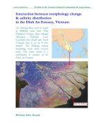
Fig. 5. Relationship between paleo-coastline in the Holocene epoch
and distribution of arca-placura placenta
PALEO-TSUNAMI
The determination of traces of the paleo-sea
water levels in the Holocene epoch mentioned
above allows us to relatively and basically
determine the vestiges and “abnormal”
geological bodies (origin, distribution location,
geo-layered orders, and size/scale) in the
following areas (fig. 6, 73):
The “abnormal” bodies in geological
sedimentation may suggest a tsunami ST1
occurring in the coastline of Nghe An (and
maybe in Ha Tinh). The tsunami waves
transported arca granosa and placura placenta
from sea floor to onshore area and formed a
field of arca granosa with placura placenta
scatter distributed in the nearshore areas and
paleo-coastlines such as Quynh Van, Quynh
Hoa, Dien Chau etc. The process of forming
the fields of arca granosa with placura placenta
is the sudden one (due to a number of arca
granosa and placura placenta still keeping their
mouths shut), and these layers of arca granosa
with placura placenta were chaotically arranged
111
Cao Dinh Trieu, Le Van Dung,…
(fig. 3, 4). The dating results of the placura
placenta of the hills give the age of 4,500 4,300 yrs. from present. There is „geological
abnormal” in this region because the sea water
level at that time was not recorded. In addition,
species of placura placenta are living only
under the sea water level of about 9 - 10 m in
depth. Therefore, in normal conditions, the sea
water level at that time must have been at 15 m
or higher. This fact cannot be accepted (as trace
of wave abrasion remained at 3 - 4 m in
height). It must be suggested that an origin of
hill of placura placenta in Quynh Van was due
to huge waves swiping up from the bottom of
sea floor which was considered as tsunami
wave. If the above suggestions were true, then
the tsunami ST1 during the time of 4,500 4,300 yrs. ago may have had a height of 6 - 8 m
and transported arca granosa and placura
placenta from a depth of 9 - 10 m into
mountain sides.
Another vestige of the “abnormal” is a hill
of placura placenta in Nghi Tien commune.
This hill of placura placenta is relatively
rounded and singly located on the surface of
the coastline sand dune of the village No.9 of
Nghi Tien commune (Nghi Loc district), which
has a height of about 6 - 7 m. The hill consists
of layers being arranged slopingly, sometimes
curvingly and sub-vertically (fig. 4). Most of
the layers contain placura placenta of 30 - 70
cm thick mixed with thin layers, lens of arca
granosa, snails interblended poorly with
polished stone pieces of sharp edges with
different sizes from some centimeters to 15 - 20
cm. The placura placenta is overlaid on each
other; arca granosa and snails are chaotically
arranged. Some samples taken from the
volumes of placura placenta mixed with arca
granosa in lower part have ages of accordingly
4320 + 60 yrs., 4380 + 65 yrs., 4310 + 110 yrs.
from present. The samples taken from upper
part, close to soil layers, have an age of 4150 +
70 yrs. from present and the samples taken
right under the hill of placura placenta have age
of 4060 + 110 yrs. from present.
More ancient volume of placura placenta
(at age of 4,380 +70 yrs. from present) has
been pushed up and overlaid on the younger
112
sedimentary layer (at age of 4,100 - 3,900 yrs.
from present) possibly by another strong
tsunami (ST2) with larger amplitude, higher
wave heights (the marine coastline of the age of
4,100 - 3,900 yrs. ago is found near the modern
coastline mentioned above), which might reach
up from 10 m to 15 m. It suggests that the
tsunami ST2 is a reason for formation of the
Nghi Tien hillock of placura placenta (at the
age of about 4,500 - 4,300 yrs. from present),
which was overlaying the sand dune of the age
of 4,100 - 3,900 yrs. from the present under the
influence of withdrawing waves. This can be
proved by existence of the hill of placura
placenta located far on-shore, in the edge of
Than Vu mountain foot in the West (a
promontory in the northern Cam bridge near
the national highway No.1A discovered by
archaeologists) and also the hills of placura
placenta scatter distributed along the Nghe An
and Ha Tinh coastlines.
A series of geological events attracting
attention is a wide distribution of large-scale
mountain sliding on the slopes of ranges of
mountains along the coastline from Den Cong
mountain (Cuong pagoda) in Dien Chau district
to Hong Linh, Thach Hai- Thach Ha ranges of
mountains (along northern Ha Tinh sea) [2, 3].
Radiocarbon dating 14C determined from
samples of sliding side (the large-scale sliding
covering the whole surface of mountain from
foot to ridge of one branch or the whole
mountain) gives the age varying from 900 to
600 yrs. from present (the area of the village
No.4 of Nghi Tien commune has the age of 750
+ 65 yrs. from present; the area of Northern
Hong Linh mountain has the age of 750 + 95
yrs. from present, and the area around the
village No. 2 of Thach Hai commune has the
age of 730 + 65 yrs. from present). At the same
time, the existing original “pebble dyke” in Su
stream (near marine shore of the Dang Cong
mountain foot in the northeast) has ages 14C in
order of 680 + 75 yrs. and 795 +100 yrs. from
present. This pebble dyke has a height of 6 – 8
m, and a width of about 50 m stretching over
200 - 300 m in length that barriers the Su
stream flow. Pebbles of high-degree selections
and the regular, clean overlaying surface of
Some preliminary results of paleo-tsunami study…
terrace of 3 - 4 m in height consist of pebbles,
chaotically craved stones of irregular abrasion
to shaped edges (river terrace and marine
abrasion?). Here the whole terrain is crossed by
stream flow. Origin of the “pebble dyke”
coincides with ages of the large-scale sliding
events (possibly due to the occurrences of
earthquakes, which were recorded by events in
historical notes and in some family annals in
the region, such as in Le family annals, family
annals of Mr. Le Minh Thuong in Nghi Thinh
commune, Nghi Loc district). According to
these records, about 600 years ago, a giant
deluge occurred, which swept away all villages
to the sea and blew out, making Nghe An
region a sand bank. All vestiges and events
mentioned above allow us to suggest possibility
of earthquake and tsunami (ST3) in the
research area that occurred in the past 900 600 yrs.
Fig. 6. Relative cross-section of layers of placura placenta interblended with arca snails and debris
in Quynh Van. The numbers in fig. 5. Original rock of the Dong Trau formation; 2. Side sliding
zone; 3. Sea sand of the Middle Holocene age; 4. Volume of placura placenta with thickness of 4 5 m; 5. Volume of placura placenta mixed with shell of arca snails interblended with stone
fragments (debris); 6. Grit-macadam and soil layer; 7. Upper layer of placura placenta; 8. Sides
covered by soil layer 9. Places, where samples were taken upwards to the cross-section
Fig. 7. Apparent cross-section from Truong Set mountain foot (Northern Cam bridge) in the West
to hillock of placura placenta in village No.9 of Nghi Tien commune in the East: 1. Rock of the
Dong Trau formation; 2. Gravelly soil of side sliding; 3. Middle Holocene marine sediment (at age
of 4,100 - 3,900 yrs.); 4. Volume of placura placenta interbedded with layers/lens of shells, snails
contains rubbles; 4a. at the hill of placura placenta in Truong Set mountain foot; 4b. Hill of placura
placenta in the village No.9 of Nghi Tien commune (at age of 4,500 - 4,300 yrs.); 5. River
sediment-river age interchanged in late Holocene; 6. Cover - soil layer
113
Cao Dinh Trieu, Le Van Dung,…
CONCLUSIONS
It is suggested that there were 3 tsunami
events caused by earthquakes occurring along
the Nghe An coastline in the past during the
periods of 4,500 to 4,300 yrs.; 4,100 to 3,900
yrs.; and 900 to 600 yrs. ago, respectively.
Among these events, the ST1 occurred during
the time of 4,500 - 4,300 yrs., had made a
formation of hill of placura placenta with acra
granosa on a mountain slope in the Western
Nghe An delta (wave height might be of 6 8 m). The ST2 occurred during the time of
4,100 - 3,900 yrs. with wave height of 10 – 15
m, had formed a volume of placura placenta on
a mountain slope in Quynh Van (due to coming
waves) and also formed Nghi Tien hill of
placura placenta (due to withdrawing waves).
Lastly, in latest time period of 900 - 600 yrs.,
possibly a strong earthquake occurred, which
caused sliding on a large scale accompanied by
a tsunami (ST3), which created a “pebble
dyke” in Su stream - the biggest deluge
occurring in the Nghe An and Ha Tinh coastal
regions.
Acknowledgements: The authors are thankful
to all the colleagues from the Institute of
Geophysics, Vietnam Academy of Science and
Technology (IGP-VAST) for their support.
REFERENCES
1. Bui Cong Que (Editor) et al., 2010.
National independent theme report
(DTDL2007G/45), 2010 on “Study on
114
assessment of hazards of earthquake and
tsunami in Vietnam coastline and islands
and proposal of solutions for preventing
and reducing consequences”. Archive of
Institute of Geophysics. (in Vietnamese).
2. Cao Dinh Trieu, Nguyen Ba Duan, Dang
Thanh Hai, Ngo Gia Thang, Bui Anh Nam
and Nguyen Dinh Nguyen, 2011. Some
study results on distribution of arca granosa
and placura placenta in Nghe An region.
Journal of Earth Sciences, 33(2), 97- 108.
(in Vietnamese).
3. Cao Dinh Trieu et al., 2011. Some primary
results of field surveys on paleoearthquakes and paleo-tsunamis along
Nghe An and Ha Tinh coastline. Journal of
Science and Technology - Hanoi Mining
University, No.34/4-2011, 84-88. (in
Vietnamese).
4. Hoang Xuan Chinh, 1996. Vestiges of
shells of arca-placura placenta in Nghe An
and Ha Tinh coastline, Vietnam
Archaeology Reports, Hanoi. Archives of
Institute of Archaeology. (in Vietnamese).
5. Ngo Gia Thang, Le Duy Bach, Cao Dinh
Trieu, 2009. The traces of tsunamis
discovered on islands along Central
coastline of Vietnam. Marine geology and
sustainable development. Natural Science
and Technology Publisher, 547-556. (in
Vietnamese).