NYSGA 1981 B7 - Some Environmental Problems Of The Binghamton Area
Bạn đang xem bản rút gọn của tài liệu. Xem và tải ngay bản đầy đủ của tài liệu tại đây (1.73 MB, 24 trang )
SOME ENVI RONMENTAL PROBLEMS OF THE BINGHAMTON AREA
MARI E MORISAWA AND BURRELL MONTZ
Department of Geological Sci ences and Envi ronmental Studies
State Universi ty of New York at B i nghamton
Bi nghamto n , New York 1 3901
THE SUSQUEHANNA RIVER BAS I N
The Susquehanna River system i s the l argest drai nage network i n the
northeastern Uni ted States dra i ni ng to the Atlantic Ocea n . Starting i n
central New York , the ri ver flows southward through Pennsy l vania and
Maryl and , dra i n i ng 27 ,51 0 square mi l es ( F i g . l ) . We are concerned only
with the eastern Susquehanna bas i n of New York in thi s report.. The river
here drains an area of 4 , 780 square mi les in New York and Pennsyl vania
above and through the Bi nghamton area to Waverly, where i t turns south
i nto Pennsyl vania and l eaves New York . The major tri butaries of the
eastern Susquehanna - Ri ver are the Otsel i c , Unadi l l a , Ti oghni oga and
and Chenango Ri vers ( Fi g . 1 ) . The Chenal)go j o i ns the Susquehanna River
at Bi nghamton . Indeed , this confluence determined the l ocation of
Bi nghamton .
The eastern Susquehanna River bas i n l i es i n the Appal achian
geomorph i c province. The bedrock i s sedimentary sandstone , s i l tstone ,
and shal e of Devonian age. The strata are essent i a l l y hor1zontal , but
are sl i ghtly arched up i nto broad , gent l e fol ds with axes ori ented north
east-southwest . T he fol ding general ly has not markedly affected
the basi c
dendri tic drainage pattern o f the section.
The regi on has been glaci ated , resul ting i n a somewhat subdued
topography. Hi l l s have been smoothed and rounded and are commonly
asymmetrical wi th steeper sl opes on the north . ·. El evations range from
2500+ feet on the upl ands to 750-850 feet along the ri ver bottom s . The
major val l eys were broadened and deepened by glaci ation and fi l l ed with
thick deposits of gl aci o-fl uvial sands , gravel s , s i l ts , and , in some
cases , l ake clays . Many of the sma l l postglacial streams have cut steep ,
narrow gorges through bedrock . The combi nation of stream types and broad ,
open upl ands gi ves a pleasi ng esthetic qual i ty to the reg i o n .
i
l
r
Glaciation had a s ignificant effect o n drai nage , not only i n ways
al ready mentioned, but al so by di srupting and bl ocki ng pre-gl aci al
drai nageways . The extraordi nary path of the Susquehanna as i t l oops down
to Pennsyl vania and back into New York east of B i nghamton i s a refl ection
of events duri ng deglaci ation . Many tri butaries flow i n "mi sfit" val l eys
whi ch are too l arge for them . Drai nage divides occur i n "through val l eys " ,
i . e . , a val l ey which i s occupied by streams one of which fl ows north and
the other south . Many obvious drai nage di versions can be seen throughout
the region .
Besi des such changes , the gl aci ers exerted the i r i nfluence on the
Susquehanna drai nage through the deposi ts they l eft . The upl ands and
val l ey side sl opes of the watershed are covered with glacial ti l l . Thi s
resu l ts i n soil s which are genera l l y impermeable and poorly drai ned .
231
N
w
N
�/�.so
� &.$'�V(/�
>'7JJ/?
�
"
"'
' -t>
BINGHAMTON
0
6000
AREA
12.000
18,000
FEET
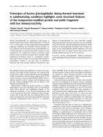
F igure 2 .
�
�
\'-
:- r�
Map o f the B i n9hamton area wi th steps indi cated ,
233
Hence , runoff is rapid and many tri butaries are "fl ashy" , i . e . , have a
quick ri se and fal l of di scharge . The thick gl aci o-fl uvial fi l l s i n the
major val l eys are good ground-water reservoi rs which susta i n fl ow of the
1 arger streams throughout the dry summer months ( Ku , Randal l and
MacN i s h , 1 975) .
The soi l s of Broome County were formed i n glacial t i l l , glacial
outwa s h , glaci a l -l ake deposi ts and more recent al l uvial deposits.
Soi l s i n the l ow-lyi ng areas , al ong the fl oodpl ains , are mostly of the
Ti oga-Chenango-Howard association . These are soi l s that are deep ,
wel l -drained , and gently s l op i ng and are, therefore , very s u i tabl e for
development. The main probl em associ ated with the se soi l s is that of
occasional fl oodi ng.
The terraces bordering the fl oodpl a i ns are primari ly Chenango, Howard ,
and Unadi l l a soi l s . Li ke those found i n the fl oodpl a i n s , these soi l s are
deep and wel l -drained ( S . C . S . , 1 97 1 ) .
I n most of the county, particularly i n the upl ands , soi l s of the
Vol usi a-Mardi n associ ation are formed on deep , gently s l op i ng to very
steep glacial t i l l . These soi l s are not s u i tabl e for most types of
devel opment, because they exhi b i t a s l owly permeabl e frag i pan . A fragi pan
i s a dense subsurface l ayer of s o i l ; it i s i ndurated , hard and s l owly ·
permeabl e . The Vol usia fragi pan i s composed of grayi sh-brown s i l t-l oam
at a depth of 1 5-22 i nches . Thi s i s not to say , however , that development
has not occurred i n areas with these soi l s ; there has been l i ttle cho i ce
because these soi l s cover about 90 percent of the county .
The g l ac i al modifi cat i on o f the topography has l a rgely determi ned the
human geography of the reg i on . Popul ation i s mostly concentrated on the
broad fl ood p l a i ns and terraces which are l ocal l y as much as two m i l es
wide . Broome County has the hi gheset popul ation den s i ty i n the eastern
bas i n , wi th devel opment concentrated i n the Tri ple Citi es (Bi nghamton ,
Johnson C i ty , Endicott) section al ong the Susquehanna ( F i g . 2 ) . The other
counties in this watershed are primari ly rural . Land use shows the effect
of s o i l type. Upl and and val l ey sl opes i n ti l l are genera l ly forested or
i n pasture. Much of the agricul tural l and i s on the broad fl ood plain
composed of g l acio-fl uvi al depos i ts .
I
t-
r--
1
I
A confl i ct i n use arises s i nce the fl ood p l a i ns are a l so the pl aces
most eas i l y and economi cal ly devel oped . The aqui fers in the val l ey fi l l
and the permeabi l i ty of the sands and gravel s for septi c systems make the
val l eys more des i rabl e for hous i n g . During the post-World War I I devel op
ment boom, extens i ve urban i zation occurred in the val l eys , al ong the
Susquehanna River i tsel f and up l a rger tributari es . At present, 66 percent
of the popul ation resides i n the strip of fl ood p l a i n al ong the
Susquehanna River . The steep sl opes of the upl ands tended to act as
natural devel opment barri ers . I t i s only recently, with continued growth
and some rea l i zation of the dangers of bui l di ng on fl ood p l a i ns , that
urbani zation has spread to the fl at upland summits and the val l ey side
s l opes . Urban i zation of these seemingly i nnocuous areas a l so brings on
drainage and ri ver problems , as wi l l be seen.
N
w
..,.
� ---
9
8
1
-..
6
0
::i
1-
w
(!)
0::
u
If)
i3
5
�
J)
A
VESTAL �
\/ CONKLIN
3
2
COLLIERSVILLE
�
192 5
29
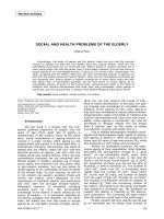
F i gure 3 .
�-�
�
,------�--�
:-- T�
-
33
�
-----37
41
45
49
53
57
61
65
69
YEAR
Annual d i schar�e o n stations a t o r upstream o f the B i nghamton area .
From tlori sawa and Vemuri ( 1 975 ) .
,------ -,-----.
-
--
-
-
r
73
235
Hydrol ogy of the Eastern Susquehanna Bas i n
The area has a humid, conti nental cl imate with a n average preci p i ta
tion of 36-40 i nches per year . Preci p i tation is genera l l y of the frontal
type , where pol ar air masses meet the more humid warm air masses moving
northeastward . The record fl ood of 1 936 was produced by such frontal
prec i p i tation combined with a spring thaw ( Susquehanna Ri ver Bas i n Study,
1 970) . Al though the summer i s dry, i ntense l ocal thunderstorms may occur.
The region a l so l i es in the path of · tropi cal hurricane s . These storms ,
ori ginati ng i n the Atl anti c or Cari bbean , sometimes swing inl and bringi ng
i ntense and excessive rainfal l . Severe damage has been caused i n the past
by these tropical storms . More recently , Agnes ( 1 972 ) and E l o i se ( 1 975)
caused con s i derabl e damage on smal l er tri butari es , but d i d not cause
damagi ng fl oods on the mai n stem.
Tabl e 1
Highest Floods of Record , Bi nghamton Area
Date
Stage
ft .
Estimated
Discharqe; cfs
Susquehanna Ri ver
Conkl i n
Vestal
Waverly
Mar. 1 936
Mar. 1 936
Dec . 1 952
20. 1 4
30 . 5
19.7
61 ,600
1 07 , 000
1 1 2 , 000
July 1 935
July 1 935
20.3
20 . 6
9 6 , 000
9 6 , 000
Chenango Ri ver
Chenango Forks
Broad Acres
Data from Susquehanna River Basi n Study, 1 970.
The water budget refl ects the di fference between preci p i tation over
the watershed and di scharge fl owing out of the bas i n . The runoff
(20.8 i nches ) reflects 54 percent of the mean annual preci pitati on . Forty
s i x percent of the rainfal l i s l ost by evapo-transpiration because the area
i s wel l forested and 87 percent of the watershed i s agri cul tural or vacant.
'
L
l
�
l
There are four oag i ng stations on the eastern Susquehanna River ma i n
stem. Annual fl ow for the periods of record and fl ow-duration curves are
s hown i n Fi gures 3 and 4. The four stations bel ow Col l iersvi l l e ( F i g . 4)
reflect the contribution of the thick val l ey fi l l whi ch act as acquifers
contri buting to stable base fl ow. Thi s is denoted by the l evel l i ng off of
the curves at approximately 98 . 99 percent of the time wi th a good
d i s charge. Note the di fference between the tai l s of these curves and
that of the Col l iersvi l l e station .
236
PERCENT OF TIME
ioO,OOO• r---'OT'.I--i---'T'0'--'2TO'-,.--,-"i'50..,.-,-
90
95
98 99
99.9
9999
WAV ERLY
VESTAL
IO,OOO
I
'
5000
"
UNADILLA
"
�'\
'\..
COLLIERSVILLE
�
"\
r-
10
f
I
_
..
Figure 4 .
_,
Fl ow-duration curves , Susquehanna River
at Waverly and upstream. From Mori sawa
and Vemuri ( 1 975 ) .
r
f
Il
.
237
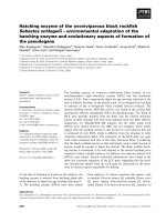
The recurrence-i nterval curves ( Fi g . 5} i ndicate the average time
i nterval at which a given di scharge recurs . These can be used ei ther to
make predi ctions of pea k fl ow or to determine the frequency of a given
storm. For exampl e , at Vestal a high discharge of 7 0 , 000 can be expected
every 5 years . On the other hand , the peak ·fl ow of the storm Eloi se i n
September of 1 975 , which was 6 1 ,500 cfs i n Vestal cou l d be expected about
every 3 years or s o , i . e . a 3-year recurrence i nterval .
The graph ( Fi g . 6 } and the regressions whi.ch relate drainage area on
the Susquehanna to mean annual di scharge and to peak fl ow a l l ow a
prediction of these di scharges , i f one knows the area of basin above any
point on the main stem. Cortland and Sherburne are on the Tioughnioga
and Chenango Rivers , respecti vely, so the i r peak annual di scharges l i e
somewhat off the regression l i ne for the mai n stem Susquehanna River.
Regress ions of mean annual di scharge COl and mean annual peak flow (Qp } to
watershed area (A} are :
Q
=
Q
=
P
l .5 A
25 . 7 A0 • 93
r = 99
•
r
=
. 96
Note that the scales on the graph of Figure 6 are l ogari thmi c .
That i s , the regress ion equations can b e written:
l og Q = l og 1 . 5 + l og A
l og Q p= l og 25 . 7 + 0 . 93 l og A
'� -
!
I
I
I
Of parti cular importance i n understandi ng the hydrol ogy of the
Binghamton area are the gages at Conkl i n above B i nghamton and at Vestal
bel ow i t . Table 2 gi ves the mean annual di scharge per square mi l e of
drai nage area of the Conkl i n and Vestal stations . Si nce the area between
these two gaging stations represents much of the urbanized stretch of the
region, an attempt was made to eval uate the change in di scharge which might
be attri buted to urban growth . I n order to di scount the amount of water
carried i nto the Susquehanna by the upper Chenango , the Vestal fl ow minus
the di scharge at Chenango Forks was used (col umn 3} . Thi s was then
recalcul ated to account for the i ncrease i n area of the Susquehanna Bas i n
to Vestal over the area of the Chenango . To mi nimi ze precipi tation vari
abi l i ty , a rati o was calcu l a ted ( col umn 5 } . Thi s ratio represents the
proportionate contri bution of the bas i n over the Bi nghamton reach to the
fl ow of the Susquehanna . Several poi nts shou l d be kept i n mind . Fi rst ,
the Chenango River contri butes a great deal of fl ow to the Susquehanna
River. Thi s is important at t imes of peak fl ow, because the city of
B i nghamton l i es at thei r confluence and backwater effects at the j unction
can be di sasterous . Al so , at time of drought the l ow fl ow of the
Susquehanna i s augmented by di scharge from the Chenango val l ey outwash
deposits . Final l y , the tab l e shows that through 1 956 there was a fairly
constant ratio of di scharge above Bi nghamton to that contributed by the
urbanized stretch. However , a spurt of devel opment i n the l ate fifties
resul ted in a j ump i n thi s ratio after 1 956 .
"'
w
(.0
100,000
�o.ooo
(J)
lL.
u
w
"'
a:
<(
J:
u
(/)
0
GO
tl l'tl
ct\E.
I'-S
f OR
5 000
1 000���------��--�--���--------_L1.005 1.01
1.05
1.11
1.25
2
- 5�----�--4-�L
5L-10
10�
0� 0
2 5- �
0 �
RECURRENCE INTERVAL , YRS
F i gure 5 .
r---�-
�
Fl ood-recurrence-interval curves , eastern Susouehanna Bas i n .
From Mori sawa and Vemuri ( 1 975) .
�-- �- -,
:1� ·"
·
239
50,000
CORTLAN�
�
��
'!r-�
(.) 5000
v�
'V{j CONKLIN
�
I1J
C)
a::
(.)
en
0
l
l
���
CHENANGO R. AT
CHENANGO FORKS
��� UNADILLA
�
�
I O L----��L-L������----L-��5��
10�
00�0��
POO
50 0
100 0
OO
Fiqure 6 .
r
'V
�'It'
BASIN AREA, SQ. M I .
Rel ation of mean annual di scharge and peak flow
to bas in area , eastern Susqueha nna watershe d.
From Mori sawa and Vemuri ( 1 975 ) .
240
Tabl e 2
Ratios of Di scharge per Square Mi l e ,
Susquehanna Ri ver at B i nghamton
(1)
Year
1 941
1 945
1 950
1 955
1 960
1 965
*
(2)
Vestal
cfs/mi 2
1 .18
1 . 27
2 . 33
1 . 35
1 . 92
1 . 83
1 . 88
1 . 55
1 . 32
1 . 90
1 . 86
1 . 68
1 . 42
1 . 25
. 1 . 50
2 . 07
1 . 25
1 . 81
1 . 35
2 . 22
1 . 58
1 .19
1 . 30
1 . 34
. 78
(5)
*
(3 )
Vestal minus
Chenango �arks
cfs/mi
Conkl i n
cfs/mi 2
V-CF/
1 .14
1 . 28
2 . 26
1 . 25
1 . 87
1 . 87
1 . 76
1 . 52
1 . 30
1 . 86
1 . 83
1 . 70
1 .42
1 . 34
1 . 50
2 . 09
1 . 23
1 .82
1 . 35
2 . 27
1 . 56
1 .16
1 . 32
1 . 30
. 72
1 .16
1 . 30
2 . 31
1 . 26
1 . 90
1 . 90
1 . 78
1 . 53
1 . 31
1 . 87
1 . 85
1 . 74
1 . 45
1 . 36
1 . 53
2.10
1 . 20
1 . 76
1 . 32
2.17
1 . 50
1 .16
1 . 28
1 . 30 .
. 75
. 98
. 98
. 98
. 98
. 98
. 98
. 99
. 99
. 99
. 99
. 99
. 98
. 98
. 98
. 98
.99
1 . 02
1 . 03
1 . 02
1 . 05
1 . 04
1 . 00
1 . 03
1 .00
. 96
(4)
c
Col umn 3/col umn 4
Fl ow data from U . S . Geol . Survey computer pri ntouts .
r
l�
[
r
I
l .
rl .
241
F i g . 7 shows that 1 945 was a year of h i g h rai nfal l , yet the rati.o
(V-CF/C) remai ned the same a s in 1 95 2 , a l ow-rai nfal l year. Thi s probably
refl ects the effect of ground-water storage . Even though 1 957 was a dry
year , culmi nati ng a downward trend i n prec i p i tation , the ratio i ncreased
and remai ned high unti l the excessi vely dry 1965 , after 5 years of drough t .
Unfortunately, the Vestal gaging station was di sconti nued after 1 965 so
data beyond that year is not avai l abl e . I t shou l d a l so be noted that
B inghamton gets its water from the Susquehanna River below the Con k l i n
gaging station and thi s may account for some l os s o f water i n the urbani zed
area . These ratios i ndicate that there has been an i ncrease in the mean
annual di scharge per square m i l e i n the urbanized B i nghamton region , a
resul t of growth and devel opment .
EFFECTS OF URBANIZATION
One of the major probl ems i n the metropol i tan areas of the eastern
Susquehanna Ri ver basi n (as i n many other watersheds) i s urban growth
and the sett l ement pattern . Early settlers establ i shed the city al ong
the river i n the broad flood p l a i n at the j unction of the Susquehanna
and Chenango Rivers . Si nce this was the eas i es t , most econom i cal , and
most access i b l e place ; the town grew by spreading a l ong the ri ver
channel .
The settlers did not understand the fact that a river develops i ts
network pattern and channel morphol ogy i n adjustment to the prevai l i ng
env i ronmental condi t i ons of the geol ogy , topography, and hydrol ogy of the
watershed . The fl ood pl a i n i s an i ntegral part of the river ' s drai nage
system, espec i a l l y during times of peak flow. At such times the river
overfl ows i ts normal channel and fl ows out over i ts extra-channel ri ght
of-way, the fl ood p l a i n . The fl ood p l a i n i s thus a normal escape val ve
for exceedi ngly high di scharges and acts to i ncrease flow capacity. I t
a l so serves to decrease veloc'\ty, acts a s temporary storage, and promotes
infil tration i nto the flood-p l a i n sediments . Fl oods al so serve to
repl eni sh the ferti l i ty of the fl ood-p l a i n soi l . Disruption of the natural
way in whi ch the stream d i scharges excessive fl ow i s dangerous .
l
l
r
Urbani zation di sturbs the natural system of l and dra i nage . Denudation
of the surface and covering the l and with bui l d i ngs , streets , and parki ng
l o ts changes the run-off and , thereby , the hydrologic bal ance . Rai n water ,
no l onger able to i nfi l trate the permeable sand and gravel s of the flood
pl ain , runs off immediately i nto the rivers . In fac t , devel opment
genera l l y aids this run-off by supplying di tches , sewers , and storm drains
to move rainfal l quickly to the l ocal streams . Such a practice i ncreases
peak fl ows and shortens the time lag to peak discharge. It a l so reduces
ground-water recharge and thus reduces l ow-fl ow rates .
The fi l l i ng of channel s and flood plains to recl aim more l and for
devel opment or for highways reduces channel capaci ty and , agai n , i ncreases
the potenti al for fl oodi n g . As urbani zation spreads fl ood hazards grow,
s i n ce runoff i ncreases with a gi ven rainfal l . A l s o , as time goes by the
probabi l i ty of more extreme rai nfal l events i ncrease s .
242
1 93 1
t-------.:r
ANNUAL PREC I P I TATION, IN INCHES
(.,)
'·J
19��
••
0
.
1 940 -
-<
� 1 950
"'
"'
1955
r
I
l
1 960
I
[
f-
1 86 -;
1931
(j.
0
·
60 normal
t
I
g
0
AN<�U"-L PREC I P I TATION. IN M I LLIMETERS
Fi !]ure 7 .
"'
g
Annual precipitation at Binghamton and Norwi ch.
( From Ku , Randa l l and MacNi s h , 1 975) .
r
l .
243
Thu s , by encroaching on the stream right-of-way, the fl ood p l ai n ,
and by converting l and to impervious surfaces , man has i nten s i fi ed the
fl ood hazard. Fl oods occur and so man reacts , and his reacti.ons have
tradi tlona l l y been i n terms of structural measures to "control " the
river. Instead of treati ng the i l l ness , he treats the ,symptoms. He
scratches the i tch i nstead of control l i ng the a l l ergy.
Fl ooding In The Bi nghamton Area
The fl ood . hi story and its sol ution i n the Bi nghamton area i s
s i mi l ar to that of other watersheds . Fol l owing heavy fl ooding i n
1 935-36 , the C i ty of Bi nghamton promoted the sal e o f $200 , 000 i n fl ood
centro 1 bonds. Money from thi s fund was used to construct fl ood wa1 1 s
on both s i des of the Chenango Ri ver and a l ong the north bank of the
Susquehanna in B i nghamton and Johnson City . Thi s was compl emented by
the Corps of Engi neers ' construction of a major fl ood-control project
i n 1 943 , bui l d i ng l evees , fl ood wal l s , and various channel improvements
(especi a l l y near Conkl in and Ki rkwood) i n the immedi ate area of
Bi nghamton on the Susquehanna and Chenan•J O Rivers . Work was 1 ater
extended to Vestal , Westover , Endi cott , and . West Endi cott . Total federal
costs of these projects exceeded 1 3 mi l l i on dol l ars ( Table 3 ) .
The l ocal costs amounted to over 1 mil l i on dol l ars .
Tab l e 3
Costs of Fl ood Protection, Study Areas (_from Tkach , 1 975)
River
Bri.xi us Creeka
Choconut Creek b
Ful l er Hol l owab
L i ttl e Choconuta
Wi l l ow Runb
Susquehanna-Chenangoc
r-
Structural Cost
+
$ 322 , 000*
1 94 , 000**
250 , 000*
60 , 000+
678 , 730*
84 , 000*
1 44 ,000
1 1 ,381 ,228 c
a pl us unknown additional amount for channel i zation
b plus Corps of Engi neers ' d i k i ng near the mouth
cprotection of B inghamton , Endi cott , Johnson City by the
Corps of Engi neers . Incl udes fl ood wal l s , di ke s , l evee s .
*
cost of channelization
**
diking
+
dams and fl ood-retarding structures
244
Upstream control s by the Corps of Engi neers consi sts of two major
reservoirs ; Whi tney Point Dam on the Otsel i c Ri ver (upper Chenango bas i n )
and East Sidney Dam on Oul eout Creek ( upper Susquehanna watershed) . The
Whitney Point Dam, compl eted i n 1942 dt a cost of 5 . 5 mi l l ion dol l ar s ,
contro� s 255 mi 2 o f drainage , and the East Sidney Dam , control l i ng
1 02 mi and completed i n 1 950 , cost over 6 mi l l ion dol l ars (Susquehanna
Ri ver Bas i n Study 1 970 ) . These dams reduce flood heights on the
Chenango Ri ver and Susquehanna Ri ver through the Bi nghamton area.
Since these projects , urbanization· has continued to i ncrease in the
Tri pl e-Ci ties area caus i ng or aggravati ng drainage problems i n major and
mi nor tri butdY'i es . After the fl oods of 1 960 Broome County received
government approval for the l a rgest single fl ood-control project i n the
Un i ted States ( PL 566 ) . The project i s a comprehen s i ve plan for n i ne
watersheds and i nc l udes dams , channel i zation , and other channel
" improvements" at a federal cost of 6 m il l i on dol l ars and a l ocal cost of
over $750 ,000 .
Tabl e 4
Average Annual Rood Damages , Susquehanna Ri ver , Binghamton
($1 000 at March , 1 974 , Price Leve l )
Loca l i ty
Conkl inKirkwood
Chenango Riverabove Binghamton
BinghamtonVestal
Normal
Exi sting
Condi t ions
Normal
Growth *
Increment
1 36 .80
1 0 . 79
Economic
Growth . **
· · I ncrement
85 . 1 2
f
'
87 . 70
2 6 . 30
40. 1 3
287 . 73
6 . 69
l l 5 . 50
Increases shou l d be added to exi sting damage for total s .
*
Damages which wi l l occur i f future
fl ood-pl ain devel opment i s contro l l ed .
**
Damages associated with improvements
and contents wi thin the flood pl a i n .
Data from Table· I I I - 5 , Eastern Susquehanna Ri ver Basin Board, 1 975 .
The desperate need for an overa l l sol ution to the growing drainage
probl ems of the Tri ple Cities region was shown by the effects of two
recent s torms , Agnes i n 1 972 and E l o i se i n 1 97 5 . Al though the upper
Susquehanna River bas i n was treated l ightly by Agnes , damage in l ocal
watersheds amounted to 1 . 25 bi l l ion dol l ars . Damage by Eloise amounted to 1 .5
m i l l i on dol l a rs (Vi ncent Vaccaro , personal commun i cation ) . Therefore ,
despite the fact that a great deal of money has al ready been spent
�·
I
t
.
[
I
I .
�
r
l.
245
i n protecti ng the Binghamton area from fl ood damages , the hazard grows
(Table 4 ) . ��oreover, the l i kel i hood exi sts that an extremel y rare storm
might overtop or break through the fl ood wal l s and l evees i n the
Binghamton area, as happened at W i l kes Barre durfng Agnes . Damage and
l oss of l i fe cou l d be staggering, s i nce the fl ood-protection structures
have provi ded a fal se sense of s·ecuri ty for i ncreased fl ood-pl a i n
devel opmen t . The normal growth i ncrement i s damage over and above
exi sting damage whi c h wou l d occur under control l ed devel opment of the
fl ood p l a i n . Economic growth i ncrement i s the increased amount of
damage wi th improvements and expansion of present fl ood -p l a i n development .
FULLER HOLLOW CREEK
Ful ler Hol l ow Creek i s l ocated on the south s i de of the
Susquehanna River in the Town of Vestal , west of Bi nghamton ( F i g . 2) . The
creek has its head on the north-faci ng s l opes of Ingraham and Bunn Hi l l s.
Bel ow Ful l er Hol l ow Road the s tream fl ows through a broad , wooded flat
area with steep s i des and i nto a c i ty park where the channel is on bedrock.
The flat above the park i s an effective storage area for excessive runoff
from above. However, the bedrock i s not far bel ow the surface as evi denced
by the outcropping i n the stream bed at the park. Once the water reaches
the bedrock section where impermeable shal e underl i es the fl ood p l a i n as
wel l as the channel , water dra i ns out and i nto the stream, i ncreas i ng .the
di scharge. Bel ow the park the s tream has been strai ghtened , shorteni ng its
1 ength by 200 feet . The creek. has been channe 1 i zed where •i t fl ows through
the S . U . N . Y . campus athl eti c fiel d and bel ow to i ts mouth . Total drainage
area i s 3 . 8 square mi l es .
·
The State Uni versi ty l ies wi thi n t h i s watershed and i s a cause of
mi nor devel opment of the nearby l ower part of the bas i n , below the park.
Urbanization has crept up the val l ey , and s ince 1 970 the area at the head ,
above Ful l er· Hol l ow Road , began to be devel oped . Now almost the entire
upper hi l l s i de , once densely forested , has been devegetated , bul l dozed , and
covered wi th a 300-home subdi v i s i o n . The surface has been modified and
tributaries and streets sewered to dra i n storm waters d i rectly and quickly
i nto Ful l er Hol l ow Creek.
�··
t
r
A typi cal hydrograph of s tream flow below the subd i v i s i on i s shown i n
Fi gure 8 . Urbani zation has. not only i ncreased storm runoff, but the
augmented flow al so rushes down the straightened section bel ow the park
with. great vigor , eroding backyards and deepening the channel . The debris
is carried off and deposi ted downstream. Two major s ites of deposi t i on of
the debri s. eroded from upstream are a cemented channel bel ow the Route 434
bridge and the mouth where Ful l er Hol l ow Creek enters the Susquehanna Ri ver.
The del ta deposi ted i n the Susquehanna by Ful l er Hol l ow Creek was
mapped during the s ummer of 1 975 when the fl ow was l ow . Much sediment had
been carried down si nce Agnes , creating a s i zeable mass of deposits. I t
i s a ss umed that much of thi.s debris was a resul t of housi ng constructi on
i n the subdi v i s i on and erosion of upstream bed and banks during high
runoff period s . Peak discharge duri ng Agnes swept away the numerous
deposits at ·the mouths of tributaries i n the area. The del ta was mapped
again i n October 1 975 , after E l o i s e . Peak di scharge of E l o i se on
Ful l er Hol l ow Creek , cal cul ated from fl oodmarks after the s torm and
246
22
20
HYDROGRAPH
F U L L E R HOLLOW C R E EK
B E LOW STAIR D E V E LO P M E N T
18
16
u
w
(f)
14 -
.....
t;
(f)
w
(!)
a::
u
(f)
0
12
j
DISCHARGE
10
I
i
8
6
I
_J
II
.
l
'
l
I
RAINFALL
Fi qure 8 .
S P R I N G - 1975
I
3
APRIL
Hydrograph o f di scharge i n Ful l er Hol l ow Creek
and rai nfa l l for the same date s .
From �1ori sawa and Vemuri ( 1 975) .
5
'
L
l
___
f-
[
l
[
r
L_
247
observati ons during i t , was 550 cfs . DesPite the high water on the
Susquehanna duri nq Eloise, the del ta grew in s i ze from 1 570 sq . ft.
before Eloi se to 2051 s q . ft. after i t . Thi s i s a l arge del ta for such
a sma l l creek . The channe l - bar deposi ts and the del ta i ndi cate that
excessive erosi on i s taking pl ace i n Ful l er Hol l ow Creek as a resul t of
urbanizati on .
On such sma l l creeks , developers shoul d be requ i red to provide
storage for runoff during storms rather than sewer the rai nfal l excess
directly i nto nearby stream channel s . There i s a l arge natural basi n at
the head of Ful l er Hol l ow Creek i n the val l ey south of Ful l er Hol l ow
Road where storm water coul d be detai ned . An al ternat i ve wou l d be to
dra i n the excess rai nfa l l underground . Straightening the channel bel ow
the park to provide for devel opment there was a mi stake whi c h shou l d be
avoi ded i n the future . Such strai ghteninq i ncreases the vel ocity of the
water, add i ng to the energy whi ch i s used for erosion . Devel opment
shou l d not be al l owed on the west bank of the creek north of Ful l er Hol low
Road and shou l d be barred from the flat between Ful l er Hol l ow Road and
Stair Par k .
FLOODING IN CONKL I N , NEW YORK
The l ow-lyi ng areas of Conkl i n , al ong the Susquehanna River ( Fi g . 2 ) ,
have been fl ooded frequently , as a resul t of both spring rai
' n s combined
wi th snowmel t and of wi nter i ce jams on the river.
Taol e 5 shows the most severe floods that Conkl i n has experienced .
Al though the 1 936 flood did not consti tute a 1 00-year fl ood , i t was
Table 5
Past Fl oods i n Conkl i n
Date
I
I
3/1 8/36
3/22/48
4/l /40
3/28/1 3
3/1 0/64
3/7/79
Di scharge , cfs
Fl ood El evation , ft .
61 , 600
60 , 500
51 ,800
5 1 ,400
50 ,200
861 . 09
860 . 78
860 . 08
859 . 25
859 . 21
858 . 21
Gage Height 840 . 95 ft .
1 00-year fl ood = 64 , 000 cfs .
Flood stage = 1 1 feet (elev. 851 . 95 )
Sources : Dunn ( 1 970) , John May (pers . comm . , Jan . , 1 980) ,
U . S . Army Corps of Engineers ( 1 971 ) .
=
r
248
devastating . Specifica l l y , the fl ood l evel was reached i n twenty-four
hours , and the river was out of its banks for five days ( U . S . Army
Corps of Engi neer s , 1 971 } .
Thi s area i s al so characterized by more minor, l ocal i zed fl ood i n g .
As a n i ndi cator o f thi s , the Susquehanna River overtopped i ts banks
sixty-fi ve times in Conkl i n duri ng the 30-year period between 1 935 and
1 964 . The most recent fl ood occurred on February 1 1 , 1 981 , as a resul t
of i ce jam s . T h i s fl ood was 6 feet above fl ood stage .
Development i n the fl oodpl a i n i n Conkl i n i s rel at i vely recent ( mostly
within the l ast 25 years ) , and therefore the h i s tory of fl ooding i s wel l
known to l ocal resi dents . , There are currently no structural measures i n
effect to protect Conkl i n , al though a channel i mprovement project , consi st
ing of seven mi l es on the Susouehanna River , was undertaken to provide
rel i ef in the event of sma l l er fl oods ( U . S . Army Corps of Engi neers , 1 969 ) .
However , di rectly fol l owi ng the February , 1 981 , fl ood ; attempts began ( and
sti l l continue ) to persuade the Corps of Engineers to construct a fl oodwa l l
i n Conk l i n . To date , the Corps has not agreed because of a l ow benefit
cost rati o , and because of probable adverse effects on downstream
communities .
MASS MOVEMENTS
I n a study of l ands l i des i n the Bi nghamton reg i on , Ott ( 1 979 ) i denti
fied 83 known sl i des and i nferred an addi tional 55 using a i r photos and
fiel d checks ( Tabl e 6 ) . From a frequency of occurrence , he rated soi l s as
to suscepti bi l i ty of s l i di ng . Vol usi a , Mardin , Canaseraga , and Unad i l l a
soi l s ( S . C . S . , 1 971 } were most susceptible to mass movement s . He al so
found that north-facing s l opes were more suscepti ble to fai l ure. Soil
characteri sti cs contributing to s l ope i nstabi l i ty were seasona l l y high
water tab l e coupled with s l ow permeabi l i ty and a dense fragi pan .
Two areas we wi l l examine have fai l ed primari l y because they are
sl opes cut to a steep angl e . Both are underl ain by Canaseraga soi l s .
Canaseraga soi l s are slowly permeabl e , have a seasonal high water tabl e ,
often have l ocal seeps , have a hi(Jh avai l ab l e moi sture capacity, and
are susceptible to differential frost heave . Cut s l opes are unstabl e
and the soi l surface i s eas i l y erodi b l e .
The north face o f Pi erce Hi l l was cut i nto for road material and
oversteepened during construction of Route 434 in the l ate 1 960s . I t
has si nce been cut back even more for devel opment . Si nce that time the
sl ope has fai l ed in a number of pl aces . The Red Lobster and Howard ' s
Florist have both gone to great expense i n attempts at stabil i �ation .
The s l ope on the east side of the Vestal Pl aza was cut i nto to
provide as eastern access to the Pl aza . Fai l ures occurred very shortly
on the north-facing sl ope . Mass movements on the south-facing side
have taken pl ace over the l ast 3 years . The town of Vestal has to
bul l doze the material from the road regul arl y , especial ly i n the spri ng .
r
,
!
l '
r
r:
r
� -
f
t
[
249
TABLE
6
Number of Landsl i des Per Quadrang l e
No. of Known
· Landslides
No. of Inferred
or Ques-ti ollab 1 e
Landsl fdes
Endicott
29
�7
.66
Bi nghamton
West
33
10
43
Bi nghamton
East
21
8
29
Total s
83
55
138
Quadrangl e
From Ott, 1 975
�
l
[
l
Total No of
Lands l i des
.•
250
REFERENCES CITED
Dunn, Bernard , 1 967 , Maximum known states and d i scharges of New York
streams through 1 967: New York State Department of Envi ronmental
Conservati on , Water Resources Divi s i on , Bul l etin 67 , 57p .
Eastern Susquehanna River Bas i n Board , 1 975 , Draft report on the study
pl an for the eastern Susquehanna R i ver bas i n , Part I I I :
Mimeographed , 27p.
Ku , H. F . , Randal l , A . D . , and MacN i sh , R . D . , 1 975 , Streamflow in the
New York part of the Susquehanna Ri ver bas i n : New York State ,
Department of Envi ronmental Conservati on , .Bu l l et i n 71 , 1 30p.
Mori sawa , �1 . and Vemuri , R . , 1 975 , Mul ti -objective p l anni ng and
envi ronmental eval uati on of water resource systems : Fina l Report ,
OWRT Project C-6065 , Grant No . 1 4-31-001 -5208 , Department of
Geo l ogical Sciences , SUNY-Bi nghamton , 1 35p.
Ott , Kyl e , 1 979, Lands l i de suscept i bi l i ty : an i nvestigation of the
B i nghamton area : �� . A . Project, Department of Geo l ogical Sciences ,
SUNY-Binghamton , 2l p .
Soi l Conservation Service, 1 971 , Soi l survey, Broome County: U . S . D . A . ,
Broome County Soi l and Water Conservation Distri ct, Bi ngHamton , N . Y . ,
p . 1 -95 .
Susquehanna R i ver Bas i n Study Coord i nating Commi ttee , 1 970 ,
Susquehanna Ri ver basin study: Appendix A - hydrol ogy , p . 260
and Appendi x C - economics and geography, 1 83p .
l
.
Tkach , S . , 1 97 5 , Inventory of structural control s , Bi nghamton area , N . Y . :
I ndependent Research Report , SUNY-Bi nghamton , l Op .
Uni ted States Army Corps of Engi neers , 1 969, Fl ood p l a i n information ,
Susquehanna and Chenango Ri vers , Broome County , New York :
Bal ti more , U . S . Army Corps of Engi neers , 57p .
Uni ted States Army Corps of Engi neers , 1 97 1 , Fl ood p l a i n information ,
Chenango River, Broome County, New Yor k : Bal ti more , U . S . Army
Corps of Engi neers , 5p .
� --
�
l.
[
r
l '
251
ROAD LOG FOR ENVI RONMENTAL PROBLEMS OF THE
BINGHAMTON AREA
CUMULATIVE
MILEAGE
MILES FROM
LAST POINT
ROUTE
DESCRIPTION
Bartle Drive Mai n Entrance to SUNY .
(west) on Route 434 .
0.0
Turn l eft
3.5
3.5
Make a U-turn just past Red Lobster onto
Route 434.
3 . 75
0 . 25
STOP 1 i n parki ng l ot of Gertrude Hawk
Candies ( Route 434) .
STOP 1 . P I ERCE HILL CUT. Thi s i s a s l ope wi th acti ve movement of
material down s l ope. Original ly a borrow pi t , the s l ope has been cut
back even more for the commerci al devel opment you see . Debri s sl i des ,
s l umps , ri l l ing and rock fal l are modes of downsl ope movement of the
g l acial materi al s . Both Howard ' s Fl or i s t and the Red Lobster have gone
to consi derabl e expense to stabi l i ze the s l ope . One debri s flow behind
the Red Lobster reached the back door, covering several cars in the way.
Subsequentl y , the wal l and dra i nage pi pes were i nstal l ed .
7.4
3 . 65
Turn ri ght ( South) onto Murray H i l l Rd. just
east of SUNY campus .
7.5
0.1
STOP 2 along Murray H i l l Rd . oppo s i te East
Gym.
STOP 2 . LOWER FULLER HOLLOW CREEK. Here the creek has been ri prapped
to prevent ero s i on of the bed and further down the banks are ri prapped .
The ri prap has progressively deteriorated , l arge b l ocks have removed
and s i de-wa l l s have s l umped.
8 6
.
f
'
i
1-
r
1 .1
STOP 3 al ong Murray Hi l l Rd . at Stair Park.
STOP 3 . MIDDLE FULLER HOLLOW CREEK. Evi dence of destructive erosion
can be seen here . The foot bridge was washed out i n the spring of
1 981 . Note wi deni ng of the channel . Excess i ve runoff from s torm
dra i ns have caused much ero s i on here. Al ong the downstream reach many
l andowners are. l osi ng their back yards .
8.9
0.3
Turn right (west) onto Ful l er Hol l ow Rd.
10.4
1.5
Turn around i n driveway on right.
east on Ful ler Hol l ow Rd.
10.8
0.4
STOP 4 .
Proceed
Martin House o n Ful l er Hol l ow Road.
rI
252
STOP 4. UPPER FULLER HOLLOW CREEK. From th i s vi ewpoi nt , one can see the
300 home Stai r devel opment. The whole h i l l s i de was wooded unti l
approximately 1 9 74-75 . Tri butaries and storm runoff are p i ped underground
di rectly to the cree k , greatly augmenti ng fl ow duri ng s torms . Di rectly
bel ow i s a meadow through wh ich the mai n creek fl ows . Thi s woul d have
been an i deal s pot for a detention pond to wh ich runoff cou l d have been
piped.
1 1 .8
1 .0
Turn l eft ( north) onto Murray H i l l Rd. to. end.
1 3 . 35
1 . 55
Turn ri ght ( east) onto Route 434.
13.8
0 . 45
Turn ri ght i nto Vestal P l aza and proceed to
southeast corner behind the Grand Uni on .
14.2
0.4
STOP 4 i n southeast corner of Vestal P l aza
behi nd Grand Uni on .
STOP 5 . VESTAL PLAZA SLOPE. Thi s cut has fai l ed i n many pl aces s i nce i t
was made . The north-facing s lope has moved much more and d i d s o more
quickly than the south-facing s l ope. The cut i s i n glacial material . Much
of the fine sediment has been removed by mud fl ows whi ch cover the road
whenever i t rai ns . Bui l di ngs and parking l ots on the surface above the
s l opes have contributed to mass movement.
f
,,
l '
Go out southeast entrance of Vestal Pl aza and
turn l eft at C l ub House Rd . (top of h i l l ) .
14.4
0.2
Turn ri ght (east) onto Route 434.
16.5
2. 1
Conk l i n Avenue e ast off Route 434 . Turn l eft
onto Tremont and then right onto Conkl i n Ave .
16.9
0.4
STOP 5 i n Crowley ' s Parking Lot.
STOP 6 . ROCKBOTTOM DAM. Th i s dam
of deteri oration on the o l der one .
of water and to produce ponding s o
Binghamton ' s water supply is bel ow
i s currently being rebui l t after years
The dam i s desi gned to retard the fl ow
that the water i ntake for the City of
the s urface even i n dry years .
1 7. 8
0.9
Cross Pierce Creek on Conkl i n Ave.
Channel i zati on i s evident.
21 . 5
3.7
STOP 6 .
1 .8
i
r .
'
i
'
l .
�···
l'
Tier gasol i ne stati o n .
STOP 6 . SUSQUEHANNA RIVER. The bend i n the river a t thi s poi nt l ed to
fl ooding of the area between the river and the gas station during the
i ce j ams i n February .
23.3
l .
STOP 7 Conkl i n Park then return west on
Conk l i n Avenue.
Il
[
r
253
STOP 7. CONKLIN PARK. This park was fl ooded enti rely duri ng the
February 1 981 flooding. Water l evel s reached up to the park s i g n .
Al though there are some bui l di ngs i n the park , they are for s torage,
primarily. Thi s park is a good exampl e of how fl ood p l a i n areas shou l d
be deve 1 oped . .
24 . 7
1 .4
Ri ght on Morris Blvd. Continue and curve to
right onto Wooderest Way.
Note the h.o uses i n thi s area (which was also fl ooded i n February) . tach
has a n i ce view of the river and gets fl ooded· a l most annual ly. These
are obvi ous examples of uneconomi c fl oodp l a i n devel opment.
r
25. 5
0.8
Turn ri ght on Inamure.
25 . 7
0.2
Turn ri ght (west) onto Conkl i n Ave.
31 . 7
6
Bear ri ght onto 434 west.
34 . 7
3
SUNY entrance.
Bartl e Drive.
25 4
Fl ood a t Conk l i n Park ( Stop 7) caused by an i ce j am , Febr u a ry , 1 981 .
[ --
r-
l
B r i dge a t Sta i r Park ( Stop 3 ) before i t was washed away , Spri n g , 1 981 .
r
l '