Advances in Satellite Communications Part 10 pptx
Bạn đang xem bản rút gọn của tài liệu. Xem và tải ngay bản đầy đủ của tài liệu tại đây (348.28 KB, 15 trang )
Advances in Satellite Communications
124
These tests are fully performed at the Remote Fusion/Decision Central Nodes as well as at
the Common Operational end user’s site of the proposed architecture. It is well beyond the
scope of this paper to further analyze this class of algorithms and techniques and how they
are integrated and implemented in fire detection software applications. Nevertheless any
early fire warning and monitoring system should consider carefully the above design and
software component issues, see (ESA, 2008; Tartakovsky & Veeravali, 2004).
Finally it is stressed that in the current literature, assumptions include discrete samples
(binary messages) and synchronous communications between the fusion center and the
sensor devices. The approaches concerning continuous time processes require additional
sampling/ quantization policies. For example fire and flame flickering is time varying and
can be modeled as a continuous random process (Markov based modeling approach). In
these cases and due to power and transmission constraints the Remote F/D Central Node
receives data in a sequential fashion and the goal is to quickly detect a change in the process as
soon as possible with a low false alarm rate. On the other hand bandwidth limitations
require efficient sampling and quantization strategies since canonical or regular sampling may
no longer be optimum.
5. Integration with First Responders communication systems
It is important in this subsection to take a step further and raise the complex issue
concerning First Responders (FRs) needs with respect to communications interoperability
extending the scope of the proposed fire detection/surveillance system. This aspect which in
our opinion is not usually addressed in various proposed detection/surveillance systems is
highly important and operationally critical to any designer who needs to consider a fully
realistic high level integrated architecture. In the case of large fire disaster and crisis
outbreaks it is highly probable that first responders teams from other European nations and
various local emergency response entities will be involved in the crisis monitoring and
mitigation efforts. Thus serious interoperability problems of the dedicated heterogeneous
communications subsystems will arise due to different communication standards. Indeed at
the technological level the variability of available technologies that are used among First
Responders networks result in a diversity of characteristics such as signal waveforms, data
throughput, latency and reliability, and security (i.e. different cryptographic standards).
This situation results in serious compromise of coordination and operational efficiency
among FRs even at the monitoring level of the events. Moreover it is well known that at a
European and national level different Public Safety authorities have adopted different
systems, equipments and often dedicated technology resulting in a multitude of networks
which are non-interoperable. Thus interoperability is in fact a critical factor for European
Public – Safety and Security teams that deal with an environment that is complex,
interconnected and highly interdependent. We only mention dedicated networks such as
Professional Mobile Radios and TETRA/TETRAPOL networks. These networks function
under different architectures and air interfaces and so internetworking (roaming capability)
is extremely difficult. Additionally new technical capabilities are continuously being
adapted by FRs such as ad-hoc mesh broadband networks which are able to provide and
extend connectivity over the affected areas of interest and to deliver high data throughput
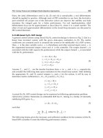
which can be higher than 5Mbs. In Figure 4 a simplified schematic is provided of different
FRs with the associated isolated networks.
Design Issues of an Operational Fire Detection System integrated with Observation Sensors
125
Fig. 4. First Responder isolated communication networks.
TETRA has been transformed from circuit switched to IP packet switched architecture (IP
protocols) for more efficient integration with other existing technologies. An open design
implementation problem then is to account for short term like solutions that will be able to
interconnect most existing communication sub-systems and networks using a possible
dedicated node ensuring interoperability of all systems without the need to modify existing
equipment such as handset devices and other communication infrastructures. In that
manner FRs will be able to continue to use current receiver equipment, communication base
stations and other critical infrastructures. Thus a specialized gateway could be a possible
unifying and cost effective alternative for technical interoperability between different FRs
networks capable of supporting across network - services (cross-network services) such as :
Voice-calls between TETRA, TetraPol and WiMAX broadband networks, exchange of
location based data, exchange of images or seamless transmission of emergency broadcast
signals over heterogeneous networks to the specific geographical area of interest or the
exchange of a high-priority information across networks. Another issue to be addressed
during the design phase is security adopted to critical situations. There are well established
techniques and methods (e.g., RSA, DES/3DES, AES encryption) that guarantee security
across networking. Nevertheless these type of measures can become a serious problem
during a major Fire event since security policies may prohibit communication across
different FRs networks. In the same context we mention the existing technical problems
related to interoperability even when the same technology is used within a country such as
communication between TETRA – TETRA systems.
For the case of Greece TETRA is the dominant technology used by emergency and
surveillance authorities. This is also the case for most European countries. In particular
Advances in Satellite Communications
126
TETRA is replacing legacy-PMR technologies, to become the most common technology to
use or it is being considered for future adoption where an emerging associated challenge is
the additional spectrum requirements for all TETRA future networks as well as Inter-
System-Interface (ISI cross border communications). We briefly mention some basic TETRA
key-services such as: Registration, Authentication, Individual Half duplex Call, Priority Call,
Preemptive Call (emergency), Broadcast Call, Instant Messaging. Also other early – adopters
are already experimenting with the use of broadband technologies such as WiMAX or
extension of current PSC coverage. In addition as is the case of the proposed Fire Detection
Operational System the exploitation of Satellites for backbone communications
infrastructure is especially critical since it provides seamless connectivity between the
critical geographical area of interest and the Common Operational Center. This type of
space based links is used by the majority of FRs of most European member countries while
cellular technology is used as a complementary means. For the hybrid model the S-band
satellite services could be used for integration and connectivity so dual use of TETRA/S-
band terminals can be exploited providing data rates up to 10Mbs, or a dual mode S-
band/L-band terminal providing data rates up to 500Mbs.
In conclusion when designing the architecture of an operational fire detection and
monitoring system technical aspects related to the integration with existing FRs
communication systems must be addressed and cannot be ignored even at a conceptual
level. These include: Interoperability of different networks based on standard protocols
(TETRA, TETRAPOL, PMR and WiMAX) or between networks of the same technology
(TETRA – TETRA). Interconnection of various full-duplex/semi-duplex networks (such as
GSM, ISDN e.t.c.), Air-Interface aspects of each different network technology such as the
existing base stations or radio terminals, Network management functions of decentralized
networks, connectivity and full integration with satellite systems.
6. Integration of operational observation platforms
In this subsection we propose specific state of the art sub-systems that can be integrated in
the proposed model, as they have reached such a maturity level that may rank them
between the operational tools in the emergency response. These components mainly
constitute more advanced earth observation and space based subsystems and assets such as
ESA’s Earth Observation program and ESA’s and EC Global Monitoring for Environment
and Security program, the so-called GMES program, with its component supporting risk
management and emergency response (ESA 2008, 2009; NOA, 2007). We mention here space
and airborne-based surveillance tools and more specifically early warning and near real
time monitoring systems with integrated fire risk and fire mapping modeling capabilities
using:
a. Medium to Low-Resolution Remote Sensing sensors.
b. High-Very High Spatial Resolution Remote Sensing for detailed mapping and damage
assessment, and identification of critical infrastructures prone to fire risk.
c. Airborne thermal sensing platforms.
Several studies show that despite the low spatial resolution of the order of a few kilometers,
the SEVIRI instrument onboard the MSG satellites, offer high potential for real time
monitoring and disaster management. According to (Roberts et al., 2004) there is a
considerable correlation between the fire radiative energy and the corresponding signals
captured by the SEVIRI and MODIS sensors. Due to this (Umamaheshmaran et al., 2007)
Design Issues of an Operational Fire Detection System integrated with Observation Sensors
127
and (Van den Bergh & Frost, 2005) exploited the high update rate of the MSG/SEVIRI
images and showed that the use of image mining methods improves significantly the
information extraction from MSG/SEVIRI in view to detect fires and model the fire
evolution.
With the occurrence of the disastrous wildfires of summers in 2007 and 2009 in Greece, the
Institute for Space Applications and Remote Sensing of the National Observatory of Athens
(ISARS/NOA) deployed its MSG/SEVIRI fire monitoring service, in complement to the
existing operational emergency response state capabilities, providing support to decision
makers during the fire fighting operations. Today the MSG/SEVIRI fire monitoring service
of ISARS/NOA is offered on a 5-15 minutes basis supporting the actions of a number of
institutional civil protection bodies and fire disaster managers all over Greece. With this
service the rapid identification of new fires arises has become possible within an average
alert time of 5 – 20 minutes. However, there are limitations relating to the instrument’s low
spatial resolution and geo-location accuracy; due to its distant geostationary orbit (i.e., 36
000 km) and the renown resolution limitations of thermal sensors, the MSG/SEVIRI has a
ground sampling distance of the order of 4 km over Greece, which, theoretically, allows for
the detection of wildfires with a minimum detectable size of about 0. - 0.30 ha see ( Prins et
al., 2001). Nonetheless, the elevated saturation temperature (>335 K) in the SWIR band
minimizes the saturation effect allowing for a sub-pixel fire characterization. This means
that, due to the important temperature contrast between the hot spots and the background,
outbursts sizing much smaller than the nominal resolution of the sensor may also be
detectable under certain conditions as it was the case in all deployed fire monitoring
operations in Greece. However, if we want to meet the existing early warning and timely
fire detection needs, these figures may not comply with standard detection requirements of
fires, the later being approximately 2-3 times smaller, namely 0.1 ha see (Rauste at al., 1999).
For this, although the MSG/SEVIRI data are, for the time being, the only satellite data that
can be used to improve the reliability in fire announcements, because of their low spatial
resolution, they cannot be used alone but as a network component, the later integrating a
variety of other sensors as proposed in this paper. It is obvious however that a space based
monitoring component as the one of ISARS/NOA, may affect significantly the sensor
network topology and lead to high simplifications, especially when the network needs to be
deployed in large geographic areas with much accentuated topographic relief as in Greece.
Referring to space based monitoring capabilities it should be noted however that much
higher spatial resolution representations can be offered from a number of polar orbit
satellite systems like SPOT, LANDSAT, IRS, IKONOS, FORMOSAT-2, etc. However, the
main difficulty with these systems is the fixed orbit geometry of the satellite platforms,
which results in restraints in revisiting capability both in tactical operations, and in
surveillance of vulnerable areas prone to high risk. In contrast, aircraft (manned or
unmanned) are much more easily maneuverable and may very quickly revisit the critical
areas providing rapid response for emergency situations. Airborne TIR sensors are usually
FLIR (Forward Looking InfaRed) cameras, capable to detect new hot spots that develop
rapidly into wildlands. Besides aircrafts equipped with FLIR sensors can be used for
supporting fire-fighters in safety tasks, and for detecting escape routes or security zones, in
areas where the human visibility is restricted due to the smoke.
For this purpose ISARS/NOA developed and is capable to deploy on demand an airborne
fire sensing service under the name SITHON see (Kontoes et al., 2009a). In reality it makes
one component of a larger network of sensors, as the whole SITHON system comprises a
Advances in Satellite Communications
128
wireless network of in-situ optical cameras, coupled with the airborne fire detection
platform of NOA/ISARS. This network is linked to an integrated GIS environment in order
to facilitate real time image representation of detected fires on detailed background maps,
that incorporate qualitative and quantitative information needed to estimate the prone to
the risk areas and help the disaster management operations (e.g. fuel matter, road network,
morphology, endangered locations, endangered critical infrastructures like fuel stations,
flammable materials, industrial areas, etc). Moreover, the platform of SITHON includes a
Crisis Operating Centre, which receives information in the form of images and data from the
wireless sensor detection systems, displays it on wide screen monitors and analyses it to
derive the dynamic picture of fire evolution. The airborne system is designed to ensure
automatic fire detection. It is mountable on any airborne platform and can be operated
within 15 to 20 minutes after the first fire announcement. Once on the platform, SITHON is
supported by a fully automated control system, which manages the frame acquisition, the
radiometric image calibration and signal thresholding, as well as the dynamic fire detection
and geo-positioning within 50-100 m error using on board GPS and INS technology and
with the lack of any operating GPS station on the ground. The minimum fire size detectable
by the system can be of 3x3 meters on the ground from 2000m Above Sea Level (ASL). The
integration of the NOA/ISARS airborne monitoring component in the proposed network
topology as indicated in figure 1, enhances the monitoring capacity of the sensor network
and improves the automatic fire detection and terrain surveillance capability in
geographically extended areas. In the following Figure 5, we provide the SITHON platform.
A 310Q CESSNA two-engine aircraft.
Fig. 5. SITHON / Platform – airborne imaging system. (Reproduced picture from (Kontoes
et al., 2009a)).
7. Future research directions
Future research directions could definitely include the integration with ESA’s Data
Dissemination System DDS, the other polar orbiting systems such as EnviSat and GMES
Sentinel spacecrafts, the integration of UAV sensors, which can provide real time data
transmission to the ground, and the improvement of algorithms and models used for raw
data processing, and data fusion and analysis of space, aerial, and terrestrial observations, to
Design Issues of an Operational Fire Detection System integrated with Observation Sensors
129
obtain higher detection accuracy and timely announcements of fire alarms. Moreover new
fire detection algorithms need to be explored and validated accounting for the local
specificities, morphological features and land use/land cover conditions of the area they
apply. To this end NOA/ISARS has proposed improvements in the algorithmic approaches
proposed by EUMETSAT for fire detection using Meteosat Second Generation satellites, and
introduced appropriate adaptations over Greece to avoid fire model detection uncertainties
and reduce the returned false fire alarms, see (Sifakis et al., 2009).
At this point, it is briefly mentioned that our proposed model could further be extended and
integrated with the web based European Forest Fire Information System consisting of two
operational sub-modules: The European Forest Fire Risk Forecasting System (EFFRFS)
which is a module for fire risk forecasting information and processing and the European
Forest Fire Damage Assessment System (EFFDAS), which is capable of evaluating and
assess the damage caused after a fire event using satellite imagery.
Furthermore, two additional elements could be certainly proposed for integration in the
proposed architecture for future deployments: Unmanned Aerial Vehicles (UAV’s) for
surveillance and monitoring tasks especially for large-scale fire events and ESA’s new
initiative of a Satellite Based Alarm System. The latter case needs further intensive technical
efforts (such as the identification of appropriate frequency selection and interoperability
aspects) taking advantage of the current GSM/UMTS systems for broadcasting messages to
mobile phone users in dedicated geographical regions were the fire event is taking place.
UAV sensors capable of carrying IR and video cameras and instrumentation with high-
resolution capabilities for dedicated fire and hot spot detection, as the airborne SITHON
observing system presented above, it seems very promising for reliable and fire monitoring
services see (ESA, 2008; Kontoes et al. 2009a; 2009b; 2009c). More explicitly they can serve
concurrently several tasks such as vegetation mapping and forestry, fire fighting and
emergency management airborne communication collection and relay, as well as
environmental monitoring before and after the fire event. With such systems further
localization and confirmation of fire sources in conjunction with the proposed fire detection
system, can be achieved therefore minimizing significantly the false alarm rate. We mention
that this type of systems and their integration with existing space and terrestrial
infrastructures are currently under ESA’s research efforts. Indeed co-operative Satellite -
UAS missions can deliver unrivalled global area coverage and time-critical, very close range
operational capabilities (ESA, 2008; 2009). Even more in the near future the European Data
Relay Satellite System (EDRS) will be a reality and further integration with the above
components will be an attractive space based sustainable solution. The EDRS system offers
(and will be technically capable in offering) real-time or nearly–real time response times for
rapid information updating and Rapid Mapping activities and Surveillance including the
“very urgent” imaging data downlink as well as meeting the growing demand for “<1
meter” resolution data availability (ESA, 2008).
Finally we should mention that in the case of Greece, several initiatives namely RISK-EOS,
SAFER and LinkER - are run by the National Observatory of Athens – Institute for Space
Applications and Remote Sensing, funded by the European Space Agency and European
Union within the GMES program framework (Kontoes et al., 2009b; Robertson et al., 2004).
These initiatives foresee the provision of additional services that respond but not limited to,
wild fire crisis management in the entirety of Greece. In particular the central and basic set
of core services provided during the crisis are near real time fire mapping (the so called
rapid mapping) at high and very high spatial resolution, as well as continuous monitoring
Advances in Satellite Communications
130
and early warning on a 15 minutes basis using medium to low spatial resolution satellite
derived products. These services are offered through dedicated gateways of GMES, making
appropriate use of properly developed interfaces linking the local End User community and
the corresponding GMES National Focal Point, that is the National Observatory of Athens
with the Emergency Response Core Services (ERSC) gateway The main aim is to rapidly
assess and disseminate information on fire occurrence and combine it with additional in-situ
and space/aerial collected data to effectively support early warning, as well as decision-
making and coordination of the emergency response actions during fire fighting. The
integration of these newly developed operational geo-information services in the framework
of GMES, to the proposed architecture is an innovative element providing complementary
fire detection and fire mapping information that needs to be considered for future
directions, in the implementation of more reliable and integrated fire warning and
monitoring architectures. In fact a large-scale deployment of the proposed system in various
geographical areas of Greece could be well complemented by the integration of additional
fire occurrence and fire spreading evidences through NOA’s established monitoring
capabilities and GMES/ERCS gateway (Kontoes et al., 2009c).
8. Conclusion
In this chapter the basic model architecture for timely and accurate fire detection and
surveillance according to operational user requirements is described. Hardware and
software issues as well as satellite, airborne and terrestrial data handling technologies have
been described and their integration to the proposed network observing architecture is
justified. Some important and mission critical communication issues related to First
Responders Network interoperability were also provided. These issues are of high priority
when it comes to further integrate and extend the proposed system with the response
emergency authorities on a national and international level. Additionally the integration of
Earth Observation platforms is commented and their integration was presented. Moreover
some important theoretical aspects of decentralized detection strategies were provided.
Time is the most crucial parameter in fire combating and fire containment. The level of
efficiency depends on the promptness of the detection system to receive and send in almost
real time its alarming signals indicating fire outbreaks and fire locations. The state-of-the-art
in most of the deployed fire sensor systems, seem not to take this into account, namely
various aspects related to sequential change detection design parameters and optimality
issues arising in decentralized detection schemes over wireless communication channels, as
proposed in this paper. On the other hand part of the existing literature regarding
distributed detection systems is strongly theoretical and involves esoteric and often deep
results from the fields of statistical estimation and sequential change detection theory.
This work concludes to an operational and realistic, in terms of efficiency and cost of
deployment, initial modeling solution, and ensures that the proposed model is easily
expanded to the newly developed and emerging Earth Observation, Telecom, Navigation,
Aviation and Advanced Sensor technological advancements, in order to efficiently address
the problem of early detection and prompt emergency response in the case of fire disasters.
The disaster management community will be soon facing a great technological peak,
enabled by the advancements in aviation, sensor and imaging technologies, telemetry, data
fusion and processing, and geo-information/value added products use. The authors are
currently involved in assisting the integration of these technologies to the daily practice of
Design Issues of an Operational Fire Detection System integrated with Observation Sensors
131
the disaster management community through on-going research and development in the
domain of state-of-the-art integrated application systems.
9. References
[1] Bassevile, M. & Nikiforov, I.V. (1993). Detection of Abrupt Changes: Theory and Application,
Information and System Sciences Series, ISBN 0-13-126780-9, Englewood Cliffs, N.J.
[2] Chamberland J.F. & Veeravalli V.V. (2006). How Dense Should a Sensor Network Be for
Detection with Correlated Observations?. IEEE Transactions on Information Theory,
Vol. 52, No.11, pp. 5099-5106.
[3] Chamberland, J.F. & Veeravalli, V.V. (2007). Wireless Sensors in Distributed Detection
Applications. IEEE Signal Processing Magazine, pp. 16-25.
[4] Cunha, L.J.; Alves, Q. & Koubaa, M. (2007). On IEEE 802.15.4/ZigBee to IEEE 802.11
gateway for the ART-WiSe architecture. IEEE Proc. of Emerging Technologies and
Factory Automation, ETFA, pp. 1388-1391.
[5] Da Silva Severino, R.A.R. (2008). On the Use of IEEE 802.15.4/ZiGBee for Time –
Sensitive Wireless Sensor Network Applications. Report of the Instituto Superior De
Engenharia Do Porto
[6] European Space Agency (2008). Internal documentation on Satellite Systems and
Operations for Unmanned Aerial Systems ESA/JCB, Advanced Research on Telecom
Systems (ARTES).
[7] European Space Agency (TLTP 2008). Telecommunications Long Term Plan (2009-2013),
ESA/JCBc 47, rev. 7.
[8] European Space Agency. Internal documentation ESA/JCB. (2009). Advanced Research on
Telecom Systems (ARTES).
[9] Fellouris, G. & Moustakides, G.V. (2008). Asymptotically optimum tests for
decentralized change detection. Proc. of the International Workshop on Applied
Probability, IWAP2008, Compiegne, France
[10] Gustaffson, F. (2008) Adaptive Filtering and Change Detection, John Wiley & Sons, ISBN
0471-49287-6
[11] Imer, O.C. & Basar, T.(2007). Wireless Sensing with Power Constraints, Springer-Verlag
Berlin Heidelberg: C. Bonivento et al. (Eds): Adv. In Control Theory and
Applications, pp. 129-160.
[12] Kontoes, C.C.; Keramitsoglou I.; Sifakis N. & Konstantinidis P. (2009a). SITHON: An
Airborne Fire Detection System Compliant with Operational Tactical
Requirements, Sensors, Vol. 9, pp. 1204-10.
[13] Kontoes C.C.; Poilvé H.; Florsch G.; Keramitsoglou I. & Paralikidis S. (2009b). A
Comparative Analysis of a Fixed Thresholding vs. a Classification Tree Approach
for Operational Burn Scar Detection and Mapping, International Journal of Applied
Earth Observation and Geoinformation, Vol. 11 No.5, 2 pp. 99-316.
[14] Kontoes C.C.; Sifakis N. & Keramitsoglou I. (2009c). GMES Burn Scar Mapping kicks
into full gear after 2007 wildfires in Greece, Windows on GMES, A BOSS4GMES
Publication, No. 3, pp. 58-63.
[15] Liolis, K.P.; Pantazis, S; Gennatos, V; Costicoglou, S; & Andrikopoulos, I. (2010) “An
Automated Fire Detection and Alerting Application based on Satellite and Wireless
Communications”, Proc. 5th Advanced Satellite Multimedia Systems Conference
Advances in Satellite Communications
132
(ASMS2010) & 11th Signal Processing for Space Communications Workshop (SPSC2010),
Cagliari, Italy, September 13-15, 2010.
[16] Marke, P. (1991). Cable tunnels - an integrated fire detection/suppression system for
rapid extinguishment, Fire Technology, pp. 219-233.
[17] National Observatory of Athens NOA. (2007) – Institute for Space Applications and
Remote Sensing, RISK EOS, extension to Greece.
[18] Prins, E.M.; Schmetz, J.; Flynn, L.P.; Hillger, D.W. & Feltz, J.M. (2001). An Overview of
Diurnal Active Fire Monitoring Using a Suite of International Geostationary
Satellites. Global and Regional Vegetation Fire Monitoring from Space: Planning a
Coordinated International Effort, edited by Ahern F.J., Goldammer J.G., Justice
C.O., Hague, The Netherlands.
[19] Rauste, Y.; Sephton, A.J.; Kelhä, V.; Vainio, T.; Heikinheimo, M.; Soini, K.;
Frauenberger, O. & San Miguel-Ayanz, J. (1999). Forest Fire Operational study:
Requirements and Analysis Report RAR, VERSION 2.3 (AO/1-3468/98/I-DC).
Report to the European Space Agency.
[20] Roberts, G.; Wooster, M.J. & Perry, G. (2004). Fire Radiative Energy: Ground and
Satellite Observations Geostationary Fire Monitoring Applications Workshop,
.
EUMETSAT.
[21] SFEDONA (n.d.) Available from:
object/index.cfm?fobjectid=29777 ESA project.
[22] Sifakis, N.; Iossifidis, C.; Kontoes, C. & Keramitsoglou, I. (2009). Wildfire detection and
monitoring over Greece using MSG-SEVIRI satellite data (submitted).
[23] Tartakovsky, A.G. & Veeravalli, V.V. (2004). Change -Point Detection in Multichannel and
Distributed Systems with Applications, In: Applications of Sequential Methodologies (N.
Mukhopadhyay, S. Datta and S. Chattopadhyay, Eds), Marcel Dekker, Inc. N.Y.,
pp. 331-363.
[24] Tsitsiklis, J.N. (1993). Decentralized Detection. Advances in Statistical Signal Processing,
Vol. 2, pp. 297-344.
[25] Umamaheshwaran, R.; Bijker, W. & Stein, A. (2007). Image Mining for Modeling of
Forest Fires From Meteosat Images. IEEE Transactions on Geoscience and Remote
Sensing, Vol. 45 , No. 1, pp. 246-253.
[26] Van den Bergh, F. & Frost, P.E. (2005). A Multitemporal Approach to Fire Detection,
Proceedings of the 2
nd
IEEE International Workshop on the Analysis of Multi-
temporal Remote Sensing Images, pp. 156- 160.
[27] Veeravali, V.V.; Basar, T. & Poor, V.H. (1993). Decentralized Sequential Detection with
a Fusion Center Performing the Sequential Test. IEEE Transactions on Information
Theory, Vol. 39, No. 2, pp. 433-442.
Part 6
High Capacity Satellite Communications
6
Passive Microwave Feed Chains for High
Capacity Satellite Communications Systems
Giuseppe Addamo, Oscar Antonio Peverini,
Giuseppe Virone and Riccardo Tascone
IEIIT –CNR Torino,
Italy
1. Introduction
The successful implementation of satellite communication systems requires robust wireless
channels providing the up-links and down-links for the communication signals. The
frequency operative bands employed depend on the particular application. Navigation and
mobile satellite systems are typically operated in the L (1-2 GHz) and S (2-4 GHz) bands,
whereas remote-sensing applications are mostly offered in C (4-8 GHz) band. In the
commercial communication area, due to the increasing demand of high quality services, the
operating frequency bands has evolved towards the Ku (12-18 GHz), K (19-21 GHz) and Ka
(27-32 GHz) bands. Although communication systems operating in high frequency bands
provide more channel capacity, the effect of free-space attenuation and atmospheric
absorption can limit the performances of these systems (e.g. signal-to-noise ratio). In this
contest, the employment of efficient transmission algorithms and protocols provide
meaningful advantages, but the bottle-neck is however represented by the antenna system
that has to satisfy very strict requirements. For these reasons each device composing the
antenna-feed chain has to be designed in order to guarantee significant electromagnetic
performances and, at the same time, high integration levels (Cecchini et al., 2009). Moreover,
when high power levels are employed (also of the order of tens of KW), further problems
are related to spurious interferences generated by non-linear devices, as microwave
amplifiers, and by metallic contacts that behave as a diode junction due to the oxidation of
the metals. Additionally, high-power and low-pressure conditions can cause multipaction
discharges in the devices (Addamo et al., 2010). This phenomenon is an exponential growth
of electrons emitted by the metallic surfaces due to the synchronism between the applied
electromagnetic field and the free electrons inside the components. The final effect consists
in the damage and even in the destruction of the RF device.
2. Antenna-feed system architecture
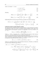
The most general architecture of a dual-band dual-polarization antenna-feed system is
shown in Fig. 2.1, where the paths covered by both the transmitter signals (in blue) and the
receiver signals (in red) are reported. The same antenna is employed in both the
transmitting (Tx) and receiving (Rx) mode, since the transmitters and the receivers works on
different frequency bands (Harwanger et al., 2007), (Cecchini et al., 2009). By considering
Advances in Satellite Communications
136
the system in the transmitting mode, the two separate microwave sources generate two
independent signals. These are combined by the ortho-mode transducer (OMT) (Peverini et
al., 2009) to obtain two orthogonal linear polarizations in a common waveguide connected
to the antenna-feed. If circular polarizations are required, then a polarizer is introduced
between the OMT and the antenna-feed in order to convert the incoming linearly-polarized
signals into left- and right-hand polarizations (Virone et al., 2008). Finally, the antenna-feed
radiates the Tx signals onto the reflector system.
In the receiving mode, the two circularly-polarized signals collected by the feed are
converted by the polarizer into two linear orthogonal ones. The OMT separates these two
orthogonal linear polarizations by routing them into two different single-polarization
channels. Subsequently, the signals are amplified by low-noise amplifiers (LNAs), and
elaborated by the back-end electronic of the receiver. Since the Rx and Tx signals are
allocated in different frequency bands, they can coexist in the first stages of the chain
without interfering each other. The diplexers allow the separation of these signals by
routing them in different paths as a function of the frequency (Virone et al., 2009). In order
to protect the receivers from spurious interfering signals generated by both internal and
external transmitters operating in different frequency bands, various stop-band filters are
inserted in the chain. Moreover, the correct behaviour of this system requires high
performances also in terms of polarization purity. For this purpose, usually a corrugated
horn is employed as the antenna-feed for its significant performances in terms of wide band
and low cross-polarization levels (Addamo et al., 2009), (Beniguel et al., 2005).
An overview on the passive waveguide devices composing this chain (i.e. filters, diplexers,
OMTs, and feed-horns) is reported in the next sessions, focusing on the main issues and
characteristics (i.e. power-handling capability), and on the design techniques.
Fig. 2.1. General architecture of a dual-band dual-polarization antenna-feed system for
satellite communication.
Passive Microwave Feed Chains for High Capacity Satellite Communications Systems
137
3. Multipactor discharge and passive intermodulation products
The trend in modern communication satellites is to increase the number of channels that can
be handled by each RF payload in order to both minimize the mass, volume, and cost of
satellites and to increase the reconfigurabilty flexibility of these communication systems. As
an example, dual-band and tri-band RF chains operating in multi-carrier condition are
currently adopted in several satellite programs for broadcast and fixed services in Ku, K, Ka-
bands (Cecchini, et al., 2010). Consequently, the RF peak-power supplied to the antenna
feed-systems can reach tens of kW. When such levels of power are employed, spurious
unwanted phenomena can occur inside the components that can concretely damage or limit
the operative function of the entire antenna-feed system. The most considerable ones are the
multipactor discharge phenomenon and the generation of passive intermodulation products
(PIMPs).
3.1 Multipactor discarge
Multipactor discharge is a breakdown mechanism that can occur under high-power and
low-pressure conditions when a proper synchronism condition between the applied
electromagnetic (EM) field and free electrons inside the components is met. Indeed, free
electrons in microwave devices operating at low-pressure conditions can be accelerated by
the applied EM field and impact onto the metallic internal surfaces. This impact can
generate additional electrons by secondary emission that in turn can strike other surfaces. If
appropriate dynamical conditions are satisfied, these repeated collisions and emissions can
lead to an exponential growth of electrons and a subsequent discharge, thus increasing the
noise level and modifying the electric parameters of the devices. Since the multipactor
breakdown phenomenon sets severe constraints on the power level that can be handled by
satellite payloads, specific device architectures are needed in order to overcome this
problem. In particular, it is highly recommended that the design of each component satisfies
suitable confidence margins with respect to multipaction discharge so that time- and cost-
expensive experimental high-power testing can be avoided in the qualification process of
the payloads. The multipactor breakdown phenomenon is based on a resonance condition
that can arise when the electron mean free path (i.e. the average distance covered by a
moving particle between successive collisions) is greater than the distance between two
opposite metallic surfaces. Moreover, two additional conditions are needed. The first one is
related to the impact time between two subsequent collisions onto the metallic surfaces.
Under a single-carrier condition, this parameter has to be an odd number M of half cycles of
the applied EM signal. The second condition implies that the arrival electron energy onto
the metallic surface is sufficiently considerable so that the effective secondary emission ratio
δ is greater than one. The latter coefficient depends also on the electrons incident angle, the
surface material (typically aluminum), and the coating process applied to the metallic
surfaces (e.g. silver-plating, alodine coating).
In order to gain a physical insight into the multipactor discharge phenomenon, it is useful to
consider the simple model of a free electron in a plane parallel-plate waveguide where an
electric field with TEM modal voltage
0
() sinVt V t
ω
=
is present (see Fig. 3.1). The motion
equation for an electron of mass m and charge e is
0
() sin
e
mx t V t
d
ω
=
(1)
Advances in Satellite Communications
138
together with the initial condition
00
()xt v=
and
0
() 0xt = . If an electron is released from
surface
x=
0 with velocity
v
0
, then integration of Eq. (1) yields the velocity from which the
position can be derived as
()
0
0
() cos cos
eV
xt t v
md
αω
ω
=−+
(2)
Fig. 3.1. Plane parallel-plate waveguide under consideration for the analysis of the
multipaction breakdown phenomenon.
()
00
2
() ( )cos sin sin ( )
eV v
xt t t t
md
ωα α ω α ωα
ωω
=−−++− (3)
where
0
t
αω
= . In order the transit time
tΔ
to the position
x=d
to be an odd number
M
of
half cycles (i.e.
/tM
πω
Δ=
), the peak voltage
0
V
of the EM field and the electron impact
velocity
v
i
must be equal to
0
0
()
cos 2sin
ddMv
m
V
eM
ωω π
πα α
−
=
+
(4)
0
0
2
cos
i
eV
vv
md
α
ω
=+
(5)
respectively. According to Eq. (4) the value of the peak voltage
V
0
fulfilling the synchronism
condition (named also the multipactor threshold voltage) depends on
α
(i.e. the time
0
t
when the electrons are released from the surface
x=
0) and on the gap-frequency product (i.e.
fd). With reference to Eq. (5), it is worth noting that the kinetic energy
2
2
i
mv
of
the primary electron striking the surface x=d depends on the peak voltage
0
V . If this energy
is sufficiently high so that the secondary electron emission coefficient
δ
of the surfaces is
greater than one, than an electron avalanche phenomenon occurs between the two surfaces.
On the basis of the previous theory, it is possible to derive the relationship between the gap-
frequency product fd and the threshold voltage
0
V for each odd-order resonance, thus
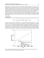
obtaining useful design tools such as the Hatch-Williams susceptibility diagrams. The latter
are the basis of the free multipactor calculator program developed by the European Space
Agency and available online (ESA, 2007), which provides the region in the
0
f
dV− plane
where the multipaction breakdown can occur for a given resonance order. Fig. 3.2 shows the
envelope over all the resonance orders of the minimum threshold voltage for a silver-plated