(Luận văn thạc sĩ) assessing climate change impacts on surface water flow for sustainable exploitation and utilization of water resources in the srepok river basin in viet nam
Bạn đang xem bản rút gọn của tài liệu. Xem và tải ngay bản đầy đủ của tài liệu tại đây (4.89 MB, 112 trang )
VIET NAM NATIONAL UNIVERSITY, HANOI
VIET NAM JAPAN UNIVERSITY
VU THI HAI HA
ASSESSING CLIMATE CHANGE IMPACTS
ON SURFACE WATER FLOW FOR
SUSTAINABLE EXPLOITATION AND
UTILIZATION OF WATER RESOURCES IN
THE SREPOK RIVER BASIN IN VIET NAM
h
MASTER’S THESIS
h
VIET NAM NATIONAL UNIVERSITY, HANOI
VIET NAM JAPAN UNIVERSITY
VU THI HAI HA
ASSESSING CLIMATE CHANGE IMPACTS
ON SURFACE WATER FLOW TOWARD
SUSTAINABLE EXPLOITATION AND
UTILIZATION OF WATER RESOURCES IN
h
THE SREPOK RIVER BASIN IN VIET NAM
MAJOR: CLIMATE CHANGE AND DEVELOPMENT
CODE: 8900201.02QTD
RESEARCH SUPERVISOR:
Dr. Akihiko Kotera
Prof. Dr. Koshi Yoshida
Ha Noi, 2021
DECLARATION
I hereby declare that this thesis is the result of my research and has not been
published. The use of other research results and other documents must comply with
the regulation. The citations and references to documents, books, research, and
websites must be listed as the thesis references.
Author of the thesis
Vu Thi Hai Ha
h
ACKNOWLEDGEMENT
First and foremost, my appreciation and gratitude go to excellent supervisors for
their guidance during the thesis research, namely Prof. Dr Koshi Yoshida and Dr
Akihiko Kotera. They have been great mentors and always being available and
responding to my emails and questions.
I would like to thank the National Center for Water Resources Planning and
Investigation and the Vietnam Meteorological and Hydrological Administration for
their enthusiastic support in providing materials and guiding me in writing my thesis.
I am also very grateful to the Danish Hydraulic Institute (DHI) offices in Ha Noi
for the incredible internship assisting me in the modelling tutorial and MIKE license
supply. My special thanks go to Mr Nguyen Ngoc Bach, who gave me so much
meaningful advice in study MIKE models.
h
I am very grateful for all the support, continuously encouragement, teaching and
guidance from all the teachers of the MCCD program have extended to me during my
time study here at Viet Nam Japan University, Hanoi National University.
Last but not least, I would like to express my indebtedness to my families and
friends who have given me constant encouragement, great patience and utmost love to
overcome all difficulties in the thesis completion.
Thank you very much!
TABLE OF CONTENTS
h
DECLARATION
ACKNOWLEDGEMENT
TABLE OF CONTENTS
LIST OF TABLES ...........................................................................................................i
LIST OF FIGURES ........................................................................................................ ii
LIST OF ABBREVIATIONS ........................................................................................iv
CHAPTER 1. INTRODUCTION .................................................................................... 1
1.1 Background................................................................................................................. 1
1.2 The research question and hypothesis ........................................................................ 2
1.3 Research objectives and tasks .................................................................................... 3
1.4 Objects and scope of the research .............................................................................. 4
1.5 Matrix of learning outcomes for the master's thesis ................................................... 4
1.6 Contribution of the thesis ........................................................................................... 5
1.7 Framework of the Master’s thesis .............................................................................. 6
1.8 Literature review ........................................................................................................ 6
1.9 Overview of the study area ....................................................................................... 12
1.9.1. Description of study area ............................................................................. 12
1.9.2. River system ................................................................................................. 13
1.9.3. Socio-economic features .............................................................................. 17
1.10 Overview climate change in Viet Nam and the Srepok river basin ....................... 18
CHAPTER 2. MATERIALS AND METHODS ........................................................... 22
2.1 Data collection .......................................................................................................... 22
2.1.1. Topography document ................................................................................. 22
2.1.2. Hydro-meteorological data .......................................................................... 22
2.1.3. Water demand data ....................................................................................... 26
2.1.4. Reservoirs and hydropower plants data ....................................................... 28
2.2 Rainfall-runoff and water balance models ............................................................... 28
2.2.1. MIKE NAM model ...................................................................................... 29
2.2.2 The MIKE HYDRO BASIN model .............................................................. 40
CHAPTER 3. RESULTS AND DISCUSSIONS .......................................................... 48
3.1 Calibration and validation of MIKE NAM model ................................................... 48
3.2 Calibration and validation of MIKE HYDRO BASIN model ................................. 53
3.3 Impacts of climate change on flow........................................................................... 55
3.3.1. The average annual flow .............................................................................. 56
3.3.2. The average flow in the rainy season ........................................................... 57
3.2.3. The average flow in the dry season .............................................................. 58
3.4 Assessing the capacity of sustainable exploitation and using water resources
under the context of climate change ............................................................................... 59
3.4.1. Water demand assessment ........................................................................... 59
h
3.4.2. Assessing the capacity of sustainable exploitation and using water resources
under the context of climate change ...................................................................... 61
CHAPTER 4. SOLUTION AND RECOMMENDATION ........................................... 67
4.1. Problems exist ......................................................................................................... 67
4.2. Solution and recommendation ................................................................................. 68
4.2.1. Innovation of policy and management: IWRM (Solutions for water resource
management) .......................................................................................................... 68
4.2.2. Climate change ............................................................................................. 69
4.2.3. Agriculture and solutions ............................................................................. 70
4.2.4. Structural measures in the Srepok river basin .............................................. 71
4.2.5. Recommendations to the government .......................................................... 72
CHAPTER 5. CONCLUSIONS AND RECOMMENDATIONS ................................ 73
5.1 Conclusion ................................................................................................................ 73
5.2 Recommendation ...................................................................................................... 74
5.2.1. Limitations ................................................................................................... 74
5.2.2. Recommendations for further study ............................................................. 75
REFERENCES .............................................................................................................. 76
APPENDIX ................................................................................................................... 82
Appendix A: The MIKE NAM model results ................................................................ 82
Appendix B: The water demand in the Srepok river basin ............................................ 86
Appendix C: The reservoirs and hydropower plants information .................................. 86
Appendix D: The rainfall projection ............................................................................ 101
LIST OF TABLES
h
Table 1.1: Research question and hypothesis .................................................................. 3
Table 1.2: Objective and tasks......................................................................................... 3
Table 1.3: Relations between results of the Master's thesis and MCCD's Program
Learning Outcomes (PLOs) ............................................................................................. 5
Table 1.4: Characteristics of the main tributaries in the Srepok river basin in Viet Nam
....................................................................................................................................... 14
Table 1.5: Average monthly flow in 1980-2015 in the Srepok Basin (m³/s) ................ 16
Table 2.1: List of rainfall stations used in MIKE NAM ............................................... 23
Table 2.2: The variation of annual average rainfall compared to the baseline period in
four provinces in the Srepok river basin........................................................................ 24
Table 2.3: Changes in seasonal rainfall (%) compared with the baseline period in four
provinces in the Srepok river basin ............................................................................... 25
Table 2.4: Water demand in the Srepok river basin (million m3) ................................. 26
Table 2.5: Reservoirs and hydropower plans ................................................................ 28
Table 2.6: MIKE NAM model parameter ..................................................................... 31
Table 2.7: The sub-basins in the Srepok river basin ..................................................... 32
Table 2.8: The evaporation and rainfall stations in the area of Duc Xuyen station ...... 34
Table 2.9: The evaporation and rainfall stations in the area of Cau14 station .............. 35
Table 2.10: The evaporation and rainfall stations in the area of Giang Son station ..... 36
Table 2.11: The calibration and validation period of MIKE NAM............................... 40
Table 2.12: The average monthly flow for the 1986-2015 period (m3/s) in the Srepok
river basin ...................................................................................................................... 43
Table 2.13: Hydropower plants information in Srepok river basin ............................... 46
Table 2.14: The calibration and validation period of MIKE HYDRO BASIN ............. 47
Table 3.1: The parameter of calibration and validation model ..................................... 49
Table 3.2: Results of calibration and validation of MIKE– NAM model at three
hydrological stations Giang Son, Duc Xuyen and Cau 14 in the study basin ............... 51
Table 3.3: Criteria evaluation result of calibration and validation of MIKE HYDRO
BASIN model at 2 hydrological stations Giang Son and Cau 14 ................................. 54
Table 3.4: Water demand deficit in 2017 (million m3) ................................................. 61
Table 3.5: Water demand deficit in 2017 by sector (million m3) .................................. 62
Table 3.6: Water demand deficit in 2030 with P=85% (million m3) ............................ 62
Table 3.7: Water demand deficit in 2030 with P=85% by sector (million m3) ............. 63
Table 3.8: Water demand deficit in 2030 with P=50% (million m3) ............................ 64
Table 3.9: Water demand deficit in 2030 with P=50% by sector (million m3) ............. 64
Table 3.10: The percentage reduces to meet the 85% water supply in agriculture ....... 65
i
LIST OF FIGURES
h
Figure 1.1: Framework of the thesis ................................................................................ 6
Figure 1.2: The Srepok river basin ................................................................................ 12
Figure 1.3: The Srepok River system ............................................................................ 14
Figure 1.4: Average monthly water level at Cau 14 station in 1980–2018 ................... 15
Figure 1.5: Average monthly water level at Duc Xuyen station in 1980–2018 ............ 15
Figure 1.6: Average monthly water level at Giang Son station in 1980–2018 ............. 16
Figure 1.7: The percentage of annual average surface water resources of sub-basins in
the Srepok river basin in 1980-2015 ............................................................................ 17
Figure 1.8: Temperature in some stations in the Srepok river basin (oC) ..................... 20
Figure 1.9: Rainfall in some stations in the Srepok river basin (mm) .......................... 21
Figure 2.1: The hydro-meteorological stations, reservoirs and hydropower plants
network. ......................................................................................................................... 23
Figure 2.2: The process and concept for the MIKE NAM and MIKE HYDRO BASIN
models ............................................................................................................................ 29
Figure 2.3. Structure of NAM model ............................................................................ 30
Figure 2.4: Sub-basin in MIKE NAM model ................................................................ 33
Figure 2.5: Thiessen polygon calculates the average rainfall of the basin to the Duc
Xuyen hydrological station............................................................................................ 35
Figure 2.6: Thiessen polygon calculates the average rainfall of the basin to the Cau 14
hydrological station. ...................................................................................................... 36
Figure 2.7: Thiessen polygon calculates the average rainfall of the basin to the Cau 14
hydrological station. ...................................................................................................... 37
Figure 2.8: Thesis’s MIKE HYDRO BASIN model setting ......................................... 42
Figure 2.9: Water users connected to the river network in thesis ................................. 44
Figure 2.10: Reservoir information in the thesis ........................................................... 45
Figure 2.11: The position of Reservoir and Hydropower plant in thesis’s model ........ 46
Figure 3.1: Calibration and validation in Giang Son station ......................................... 48
Figure 3.2: Calibration and validation in Duc Xuyen station........................................ 48
Figure 3.3: Calibration and validation in Cau 14 station .............................................. 48
Figure 3.5: Frequency curve and respective flow values calculation by computer
program FFC 2008 ........................................................................................................ 53
Figure 3.6: Observed and simulated flow at Giang Son station and Cau 14 station ..... 54
Figure 3.7: Average annual flow in 1986–2005 and 2016–2035 periods ..................... 56
Figure 3.8: The average annual flow change in 1986–2005 and 2017–2035 periods ... 56
Figure 3.9: The average flow years in the rainy season ................................................ 57
Figure 3.10: The average flow years change in the rainy season .................................. 57
Figure 3.11: The average annual flow in the dry season ............................................... 58
Figure 3.12: The average annual flow years in the dry season ..................................... 58
Figure 3.13: The water demand in 2017 ........................................................................ 60
ii
Figure 3.14: The water demand in 2030 ........................................................................ 60
Figure 3.15: The water demand by sector in 2017 ........................................................ 60
Figure 3.16: The water demand by sector in 2030 ........................................................ 61
h
iii
LIST OF ABBREVIATIONS
CC
Climate change
CMIP5
Coupled Model Inter comparison Project Phase 5
DHI
Danish Hydraulic Institute
DWRPIS
Division for Water Resources Planning and Investigation for the South
of Viet Nam
IPCC
GCM
HPP
NAWAPI
MONRE
MARD
RCPs
R-R
SWAT
UNICEF
VMHA
WMO
Intergovernmental Panel on Climate Change
General Circulation Model
Hydropower plant
National Center for Water Resources Planning and Investigation
Ministry of Natural Resources and Environment
Ministry of Agriculture and Rural Development
Representative Concentration Pathways
Rainfall-Runoff
Soil and Water Assessment Tool
United Nations International Children's Emergency Fund
Vietnam Meteorological and Hydrological Administration
World Meteorological Organization
h
iv
CHAPTER 1. INTRODUCTION
1.1 Background
Given the impacts of global warming and sea-level rise, climate change is one of the
biggest challenges to humanity in the 21st century, especially for the island and coastal
states. Climate change has been making the impacts of natural disasters more severe,
exacerbated the harmful effects of floods and droughts in many places, exacerbating
water scarcity and contaminating water supplies (UNICEF, 2021). According to the
Inter-governmental Panel on Climate Change (IPCC) report on climate change, Viet
Nam is one of the most affected countries by those impacts (IPCC, 2007).
Furthermore, Viet Nam also faces many challenges, especially in water resource
management and use - one of the fields directly and severely affected by climate
change.
Climate change increases temperature and changes the seasonal distribution of rainfall,
causing changes in inflows, floods frequency and drought characteristics. (Tabari,
h
2020). Meanwhile, due to socio-economic development and population growth, water
demand increases, leading to the imbalance of supply and demand, which
consequently leads to competition and crisis in water use.
These factors directly affect not only economic development but also social security.
Therefore, it is necessary to have synchronous and specific solutions with a long-term
strategic vision to solve sustainable water use in the context of climate change.
For this purpose, the thesis "Assessing Climate Change Impacts on Surface Water
Flow toward Sustainable Exploitation and Utilization of Water Resources in the
Srepok river basin in Viet Nam" is developed to provide a partial overview of climate
change impacts on water resources. Besides, the problems of using water resources
will be thoroughly analyzed. Finally, the thesis will provide specific solutions to solve
the problem.
However, within the framework of a master's thesis, it will be challenging to consider
the above problem on a national scale due to time constraints and other factors. Hence,
the author has selected the Srepok basin to study and solve the above issues.
1
The Srepok river basin, a sub-basin in the Lower Mekong, was selected as the study
area. Located within Viet Nam, the river basin area spans an area of 18.264km2 and
covers the administrative boundaries of four provinces: Gia Lai, DakLak, DakNong,
and Lam Dong (MONRE, 2017). Recent studies have shown that climate change in the
Srepok basin is indicated in the increasing trend of rainfall reduction and temperature
(Dao, 2013). The results of projecting climate change scenarios based on the Statistical
downscaling model (SDSM) determined that annual rainfall and annual temperature
will increase in the future, but rainfall will decrease in the dry season (Dao et al.,
2015). The study based on three-climate change scenarios has been detailed from the
IPCC’s CMIP5 program indicates that in the Srepok river basin, the flow tends to
decrease sharply in several months. The transfer between the two seasons and the dry
season, especially at Duc Xuyen station, reduces by nearly 80% in June. This has
increased the risk of a prolonged drought in the basin (Nguyen et al., 2018). Therefore,
it can be seen that climate change is implicit in extreme weather events with increasing
intensity and unpredictability.
In addition, significant problems exist in the management of water resources in the
h
Srepok river basin, including floods, droughts leading to environmental degradation
(such as water pollution), erosion, and sedimentation of reservoirs, over-exploitation
of groundwater, conflict of water use for different purposes, conflict of river
boundaries (between provinces and districts). In 2016, over 70% of dams and over
80% of dug wells went dry due to prolonged drought. As a result, more than 3,000
hectares of coffee and 2,200 hectares of pepper in the Central Highlands were lost. In
March of 2020, the total flow on most of the rivers in the Central Highlands is 15–70%
lower than the multi-annual average (MONRE, 2020), causing thousands of billions
Dong damage and affecting people’s lives.
Moreover, rapid population growth, agricultural expansion and industrial development
have led to increased water demand, resulting in increased competition and conflicts
among water users. Therefore, it is necessary to study and assess the flow in the basin
both now and in the future under climate change to provide timely solutions.
1.2 The research question and hypothesis
Table 1.1 shows the research questions and hypotheses of the study.
2
Table 1.1: Research question and hypothesis
Research questions
Hypotheses
How does climate change affect In the future, the flow will increase in the
surface flow in the Srepok river rainy season and decrease in the dry season.
basin?
How does climate change affect Under climate change, the water deficit in the
sustainable exploitation and use of Srepok river basin in the future is higher than
water resources?
that at present.
The water resources are not enough to supply
for all sectors, especially in agriculture.
What options can be utilized to General solutions and recommendations are
mitigate water shortage in the Srepok given with focusing on agricultural and
river basin under climate change?
structural solutions, which are suitable for the
h
Srepok river basin.
1.3 Research objectives and tasks
The research objectives and tasks are described in Table 1.2.
Table 1.2: Objective and tasks
Research objectives
Tasks
Ob1: Simulation of the
surface water flow of the
study basin at present and in
the future.
Data collection
Adopt and analyze climate change and sea-level
rise scenarios for Viet Nam (RCP8.5) published in
2016
Applying a MIKE NAM model to simulate current
flow and predict the flow in the future.
Ob2: Assessing the
Assessing water demand for each sector.
exploitation and utilization
Applying a MIKE HYDRO BASIN model to
simulate the water balance at present and in the
3
Research objectives
Tasks
of water resources at present
future.
Assessing sustainable exploitation and utilization of
and in the future.
water resources in the context of climate change.
Ob3: Proposing solutions Collecting information related to solutions and
recommendations to improve the effectiveness of
and recommendations to
exploit
and
use
water
water resources exploitation and utilization.
resources sustainably in the Proposing suitable solutions, recommendations for
the Srepok river basin conditions.
context of climate change
1.4 Objects and scope of the research
The research studies the impacts of climate change on water resources temporally.
This research focuses on the surface flow and water balance change of the Srepok river
basin in Viet Nam under climate change to support the sustainable exploitation and use
of water resources.
1.5 Matrix of learning outcomes for the master's thesis
h
This study could lead to several results and outcomes listed below:
- Result 1 (R1): The effects of climate change on the flow at present and in the future.
It is predicted that the flow will increase in the flood season and decrease in the dry
season.
- Result 2 (R2): The possibility of sustainable exploitation and utilization of water
resources at present and in the future - the context of climate change. The water
demand is rising combine with the impact of climate change leading to water shortage
in many areas in the Srepok river basin.
- Result 3 (R3): Solutions, recommendations for Srepok river basin.
- Outcome 1 (O1): References for planning and socio-economic development of the
provinces
4
Table 1.3: Relations between results of the Master's thesis and MCCD's
Program Learning Outcomes (PLOs)
Results of the Master’s thesis
PLOs
R1
R2
Other outcomes
R3
PLO1
O1
x
PLO2
x
x
x
PLO3
x
x
x
PLO4
x
x
x
PLO5
x
x
x
PLO6
x
x
x
PLO7
x
PLO8
x
x
h
PLO9
x
x
x
x
1.6 Contribution of the thesis
(i). Thesis analyzed and evaluated the natural features and water resources
characteristics in the Srepok river basin. The Srepok river basin was delineated into
six sub-basins suitable for natural conditions and water resources exploitation and use.
(ii) Setting up the MIKE NAM and the MIKE HYDRO BASIN models version 2021
for the Srepok river basin at present and in the future under climate change.
-
Update the latest climate change scenario
-
Update new water usage information
-
Update the latest regulations, standards, circulars and decisions related to water
resources in the Srepok river basin
(iii) Assessment and forecast of water resources in the basin: water resources potential,
surface flows, shortage water area under the impact of climate change
5
(iv) Based on the water shortage identification in each sub-basin and water-using
sector. Proposing sustainable water exploitation and use solutions in the Srepok river
basin.
1.7 Framework of the Master’s thesis
Figure 1.1: Framework of the thesis
h
1.8 Literature review
All climate system elements, including the atmosphere, hydrosphere, cryosphere, land
surface, and biosphere, are influenced by water. Changes in the atmosphere's water
vapor concentration, cloud cover, and ice impact the earth's radiation balance and play
a crucial part in determining the climatic response to rising greenhouse gas emissions
(Bates et al., 2008).
From the 1980s forward, scientists began to study the effect of climate change on
water resources. The World Meteorological Organization (WMO) assessed climate
change's influence on hydrology and water resources in 1985 (Houghton, 1996).
According to IPCC (2008), observational data and climate forecasts show that
freshwater resources are sensitive to climate change and can be severely damaged. The
ability of the atmosphere to store moisture increases as temperature rises, increasing
the hydrological cycle. The main differences in the hydrological system include
variations in the seasonal distribution, intensity, frequency of precipitation, therefore,
6
causing changes in water availability in surface runoff and soil moisture (Judith et al.,
2013).
Normally, studies of climate change impact water resources predict the trend of
changing flows and water supply in the upstream, mainly through temperature,
precipitation and evaporation. However, because of regional climate change
variability, climatologists can only make educated guesses about what will happen in
the future. Therefore, academics in climate change study use the keyword "scenario"
to characterize the future condition of climate change.
A General Circulation Model (GCM) is a climate model widely used worldwide to
understand the climate and forecast weather and climate change. Even though GCMs
have produced impressive results in climate simulation for the past and anticipated
future climates, it is difficult to directly use GCM outputs for local scale because of
their raw spatial and temporal resolution (Elsner et al., 2010). Therefore, different
scaling methods are required to be used. The Coupled Model Intercomparison Project
Phase 5 (CMIP5) developed climate change scenarios called Representative
Concentration Pathways (RCPs) (Meinshausen, 2013). RCP scenarios have been
h
demonstrated in studies as an acceptable strategy for investigating future climatic
conditions to undertake climate change impact analyses and develop mitigation actions
(Van, 2011).
Several studies have illustrated the effects of climate change on the hydrological cycle
at the catchment scale in both Viet Nam and in the world, as in the cases of the Rhine
river (Lenderink et al., 2007), Seine river (Ducharne et al., 2010), Red- Thai Binh river
basin (Tran, 2010), Mediterranean basin (Pascual et al., 2015). Taye et al. (2011) used
the downscaled forcing data from General Circulation Model (GCMs) to develop
climate change scenarios and assess climate change impacts on hydrology for the
upper Nile Basin. The results showed that the flow would increase in the Nyando basin
in 2050, while in the Tana basin, it tends to be ambiguous in medium discharge and
high/low discharge. The SRES A2 scenario of climate change was used to simulate the
impact of climate change on the flow regime of the Han River basin (Kim et al., 2011).
The results proved that the minimum discharge for different periods tends to increase
compared with the current hydrological conditions. Devkota and Gyawali (2015) used
7
climate data obtained from two Regional Climate Models (PRECIS–HADCM3Q0 and
PRECIS–ECHAM05), based on the IPCC–SRES A1B scenario to simulate
hydrological impacts in the Koshi River Basin, Nepal.
In the Mekong River Delta, Yusuf and Francisco (2009) provided information on the
most vulnerable area by climate change impacts in Southeast Asia. The effects of
climate change on the Mekong River Delta are neither noticeable nor consistent.
However, studies proved that the dry season might prolong and intensify in some
areas, while the rainy season may shorten and strengthen others. As a result, seasonal
water shortages, floods and saltwater intrusion into the delta might worsen (Hoanh et
al., 2003; Snidvongs et al., 2003; Chinavanno, 2004). Hoang et al. (2018) used CMIP5
climate prediction for hydrological impact assessments in the Mekong River Delta.
Analysis results showed the increase in river discharge on a seasonal and annual basis,
increasing in intensity and frequency. On the other hand, shallow currents were
projected to occur less under climate change conditions.
In terms of the small river basin, Tran (2010) used six climate change scenarios to
assess the impacts of climate change on water resources in the Huong River basin in
h
Central Viet Nam. The results proved that climate change would raise the rainfall,
leading to the river discharge increase. Conversely, a decrease in river runoff is the
result of reduced precipitation and increased water evaporation. In 2011, the author
evaluated the impact of climate change on socio-economic sectors and suggested
climate change adaptation options for Thua Thien – Hue province. Another research of
Tran (2011) also forecasted flooding levels in the Dong Nai river basin from 2020 to
2100, considering climate change. The maps were created using three climate change
scenarios, B1, B2, and A1FI, and varying sea-level rise. The studies showed an evident
shift in forecast flows compare to the average annual flow.
Climate change affects not only surface water but also groundwater. Bui (2013)
detailed climate change scenarios in evaporation, temperature, rainfall, water level, sea
level in the dry season and rainy season to serve as input models. The groundwater
flow model assessed the impacts of climate change on the absolute elevation of the
water level, the value of lowering the groundwater level, and the total groundwater
storage. The predicted saline gradient model assessed climate change impacts on the
8
salinity margin shift in aquifers. Across the delta as a whole, in the 2020–2060 period,
total water storage increases, but in the 2070–2100 period, total storage decreases in
B1, B2 and A2 scenarios.
Climate change will cause global rainfall and temperature to vary over time and space,
leading to flow change. Hydrological simulation tools are used to process information
about hydrological changes by climate change. There are currently three hydrological
models typically used to estimate hydrology and water resource change: statistical
experience, conceptual hydrological, and distributed hydrologic models.
Jakimavičius and Kriaučiūnienė (2013) used hydrological modelling Hydrologiska
Byran's Vattenbalansavdelning (HBV) software to assess the influence of climate
change on the Lagoon's water balance. According to the research results, climate
changes would influence the Curonian Lagoon's water balance component. Compared
to the baseline period (1961–1990), inflow and outflow from the Baltic Sea into the
Lagoon will decline by 20.4% and 16.6%, respectively, from 2011 to 2100.
Uniyal et al. (2015) used the Soil and Water Assessment Tool (SWAT) model to
h
analyze the influence of climate change on the water balance components of the Upper
Baitarani River basin in Eastern India. The author concluded that future climatic
conditions would most likely significantly impact streamflow in the studied area
towards the end of the twenty-first century. In the Srepok river basin, Quyen et al.
(2018) used the SWAT model to assess the impacts of climate change on water and
soil resources based on three detailed statistical scenarios from the IPCC CMIP5
program. The general results indicated that the runoff rule decreases in the dry months
and increases in the rainy months in plans. Moreover, the SWAT model was applied to
simulate the change of flow under climate change in Dong Nai river basin (Nguyen,
2012) and Cau river basin (Tran et al., 2017).
Nguyen (2015) used the hydraulic model HEC-RAS integrated with the HEC-GeoRAS
module to build a flood map. The results showed that climate change substantially
impacted flooding, which was also considered the cause of an increase in the
frequency and extent of flooding in the Nhat Le river basin. Olkeba (2016) also used
this model to assess climate change impacts on water balance components of Heeia
watershed in Hawaii. Climate change projection scenarios showed that rainfall
9
decreases in the wet season and increases slightly in the dry season, reducing water
balance components. Recently, a group of researchers assessed climate change impacts
on hydrology and river morphology in the Chindwin River Basin, Myanmar, using a
coupled MIKE NAM and MIKE 21 model. The results indicated that extreme events
(floods) are expected to be more severe in the future in terms of frequency and
intensity compared to the baseline period (Shrestha et al., 2020). These projections
provide insight into the hydrological changes caused by climate change, which have
important implications for socio-economic and ecological development.
In different regions, changes in precipitation and hydrological cycles due to climate
change may increase water shortages in many areas. (Janet et al., 2004, Zubaidi et al.,
2020). Regrettably, present water management methods do not adaptable or flexible to
changing circumstances. As a result, large infrastructure projects of the 20th century
were built to assume that water supplies would remain relatively stable over time
rather than with a long-term view of climate changes. (Versini, 2018).
Many studies worldwide on water supply demonstrated that water demand is expected
to increase in the future, especially in the agricultural sector. In contrast, the results
h
from hydrological models proved that the flow would decrease in the dry season
(Ashofteh et al., 2013; Whateley et al., 2014; Tukimat et al., 2017). Consequently,
water shortages happen in many places of the world. For example, in Spain, droughts
had occurred over the past ten years, and water reserves had been near warning limits
over a large part of the territory (Moran-Tejeda et al., 2010). Therefore, reducing crop
area and increasing water use efficiency may be an acceptable adaptation approach for
maintaining crops in the future. Besides, there is a need to implement a suitable water
demand management system to achieve water resource sustainability (Yang et al.,
2014; Xiao–Jun et al., 2015)
Many studies have been conducted worldwide to assess the impacts of climate change
on water resources and water balance. Several methods have been proposed, including
those using output from CMIP5, for example, ECHAM5 and HadCM3 climate models,
to predict future climate changes. Combining hydrological models such as SWAT,
MIKE NAM, SLURP, Hydrologiska Byrans Vattenbalansavdelning (HBV) also helps
assess the impact of climate change on flows. The results are diverse and usually
10
demonstrate the difference in flow and rainfall due to climate change. These studies
focus on stating the influences of climate change on the evolution of hydrometeorological characteristics and identifying the results caused by those impacts.
Thus, the importance of considering changes in water resource composition in the
context of climate change is proved.
Some other studies focused on assessing the impact of climate change on future water
demand, using models such as WEAP, CROPWAT. However, most of these models
mainly focus on analyzing the effects of climate change on water demand in
agriculture, as this sector is considered the most significant water user. The authors
also mentioned the influence of irrigation works. After that, a series of solutions were
proposed, including changing crop structure and managing water demand.
In brief, there have been many studies on climate change affecting water resources
globally in general and in Viet Nam in particular. The results from previous studies are
highly diverse and practical. Those studies identified the impacts of climate change on
water resources, analyzed the effects of climate change on water demand, and offered
appropriate solutions. Findings from the above studies have shown that (i) Using
h
climate change scenarios is the generally accepted approach; (ii) Hydrological
modelling is an effective tool to assess flows under climate change.
However, it can be said that very few studies have been carried out on the Srepok river
basin that takes into account the possibility of sustainable water exploitation and use in
the basin at present. Most of the Srepok river basin studies have just stopped assessing
the impacts of climate change on water resources. In addition, there are no studies that
use a complete set of modelling tools to evaluate the effects of climate change on flow
and water balance, especially using MIKE modelling. The MIKE model version 2021
is the latest and most modern model, so no studies have used this tool in the Srepok
river basin before. Besides, studies on climate change were also carried out many
years ago, so this thesis's data can be considered the most up-to-date.
Therefore, the thesis “Assessing Climate Change Impacts on Surface Water Flow
toward Sustainable Exploitation and Utilization of Water Resources in the Srepok
river basin in Viet Nam” will provide an overview of the current state of water
11
resources in the Srepok river basin and propose appropriate solutions to solve existing
problems.
1.9 Overview of the study area
1.9.1. Description of study area
a) Geographical location
The Srepok River is located to the west of the Annamite Mountains in the Central
Highlands region of Viet Nam. This is one of the major river systems and plays an
essential role in developing the economy and tourism in the area. Along with the
Sekong river and Se San river, the Srepok river is one of the Mekong River tributaries,
originating in the Central Highlands, flowing through Cambodia and confluence with
the Mekong River Stung Treng. The Srepok river basin in Viet Nam, with a total area
of 18,061 km², shares borders with the Sesan river basin in the north, Ba River and Cai
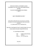
River in Nha Trang city in the east and the lower section of the Srepok river basin in
Cambodia in the west (Figure 1.2).
h
Figure 1.2: The Srepok river basin
(Source: DWRPIS, 2015)
b) Topographic characteristics
12
The Srepok river basin is generally flat in the lowlands, with some small
mountains north of Lumphat running from the east to the border with Viet Nam. There
are several mountains in the southern region of the Srepok basin, to the west of Dak
Mil. The topography of the Srepok river basin is more mountainous than the upper
reaches, especially in the southwest of Buon Ma Thuot. However, most of the area of
the Srepok river basin in Viet Nam is at quite a pretty low altitude (525 m on average).
About half of the Srepok river basin has a slope of less than 1o, although some very
steep spots can be seen in the upper catchment.
c) Climate characteristics
The Srepok river basin has a tropical monsoon climate.
Temperature: Average temperature at altitudes of 500–800m arranges from 22oC to
23oC. The average temperature in the areas at the height of below 500m ranges from
24oC to 25oC. In the rainy season, the average temperature in many months fluctuates
from 23oC to 24.7oC.
h
Evaporation: The highest evaporation in the 1980–2017 period is 1,464.8 mm at Buon
Ma Thuot stations. The evaporation changes are consistent with the temperature
variation distributed in the year. The smallest evaporation occurs in the rainy season of
the year, August and September. The average evaporation in these months is only
about 41mm.
Humidity: The annual average relative humidity in the basin ranges from 80 to 85%.
Relative humidity changes quite markedly during the year. The lowest monthly
average relative humidity occurs in February and March, and the highest in August,
September, and October.
1.9.2. River system
1.9.2.1. Overview
In Viet Nam, the Srepok river basin includes the main Srepok River and five major
tributaries: Ia Drang river, Ia Lop river, Ea H'Leo river, Ea Krong Ana river and the Ea
Krong No river (Figure 1.3 and Table 1.4).
13
.
Figure 1.3: The Srepok River system
(Source: DWRPIS, 2015)
Table 1.4: Characteristics of the main tributaries in the Srepok river basin in
Viet Nam
h
No.
River
Catchment area (km2)
Length (km)
1
Ia Drang
1,028
82
2
Ia Lop
1,755
120
3
EaH’leo
3,306
149
4
Ea KrongAna
4,013
215
5
Srepok
4,255
126
6
Ea KrongNo
3,833
156
(Source: DWRPIS, 2015)
1.9.2.2. Water resources feature
a) Water level
The flood season in the SrePok river basin starts from July to December. The flood
usually appears from August to November; some early floods can start from June.
14