Báo cáo lâm nghiệp: "The evolution of natural floodplain forests in South Moravia between 1973 and 2005" pptx
Bạn đang xem bản rút gọn của tài liệu. Xem và tải ngay bản đầy đủ của tài liệu tại đây (485.72 KB, 15 trang )
340 J. FOR. SCI., 54, 2008 (8): 340–354
JOURNAL OF FOREST SCIENCE, 54, 2008 (8): 340–354
Forest communities bound to broad shallow river
valleys are ecosystems under a long-term intensive
anthropic influence. The way they look today is
the result of centuries of cultivation and selection
of a combination of tree species, forest type, and
form of its regeneration in order to achieve the best
functional and economic yield. ese criteria were
continuously adjusted according to changing human
needs.
e history of Ranšpurk and Cahnov-Soutok Na-
tional Nature Reserves (hereinafter Ranšpurk and
Cahnov-Soutok) has been described in many texts
(e.g. V 1997, 1998; V et al. 2006). Historic
surveys have shown that in these cases the forests
were altered by people in the past. Intensive grazing
of domestic cattle in the forests was practised until
approximately the second half of the 19
th
century.
Once it ceased, the forests suffered from a strong
pressure from deer and other game kept in enclo-
sures. is game reserve was established between
the 1960’s and 1970’s. Although the forest stands
on both sites underwent logging in the past, it can
be assumed that the gene pool of woody species
was not substantially disrupted there. In 1949, the
Supported by the Ministry of Education, Youth and Sports of the Czech Republic, Projects No. VaV-SM/6/153/05 and MSM
6293359101.
e evolution of natural floodplain forests
in South Moravia between 1973 and 2005
P. U, P. Š
Department of Forest Ecology, Silva Tarouca Research Institute for Landscape
and Ornamental Gardening, Brno, Czech Republic
ABSTRACT: Since the mid-1970’s, the landscape around the confluence of the Morava and Dyje rivers has undergone
substantial changes related to the drop of water table caused by water management measures undertaken on both ri-
vers. Periodical spring floods are among the phenomena lost due to ameliorations. In this study, the reaction of forest
ecosystems to the decrease in soil moisture is assessed on the basis of changes in species composition of the herb layer
as well as of the known requirements of individual recorded taxa and the entire herb synusiae for the water content
of soils. e results confirm that the species with the greatest demand for water disappear over time. e tendency of
decreasing Ellenberg indicator values of the herb layers within the phytocoenological relevés is obvious also with the
consideration of the influence of different numbers of species recorded on the same plots in different years of the survey.
e changes are most visible in the dampest habitats, while elevated sites, so-called “hrudy”, tend to be most stable.
e intensity of vegetation changes increases in direct proportion to the altitude of the sites. e process of changes
in some habitats caused by the alteration of the water regime has to be separated from the changes in the vegetation
structure, which are easier to observe optically. e limiting factor of their development in the given conditions is the
forest wildlife. After the elimination of wildlife’s influence, the woody species synusia differentiates in height. A quali-
tative shift is represented by the recession of the formerly dominant Quercus robur on the main level, and its gradual
replacement by other species. e impact of changes going on in the woody synusia on selected characteristics of the
herb layer are included in the analyses.
Keywords: floodplain forest; phytocoenosis; woody synusia; herb synusia
J. FOR. SCI., 54, 2008 (8): 340–354 341
Ranšpurk and Cahnov-Soutok sites were declared
State Nature Reserves, which meant the forests were
left to develop without intervention. At the end of
the millennium, the protected areas were fenced off
to prevent further damage by game.
Many authors focused on the study of forest
ecosystems of the South-Moravian floodplains
(M 1956, 1958; V 1959; H 1969;
S, B 1989; M 2001; V
2002, and others). e published texts often issue
from repeated surveys carried out in one or both
these reserves. e authors usually concentrate on a
particular segment of the plant society. Dendromet-
ric surveys are accompanied by phytocoenological
relevés used to illustrate the complex conditions of
the sites. Assessment of phytocoenoses, on the other
hand, is based on the monitoring of the herb layer
with information about the species composition of
the shrub and tree layers. Certain separation of the
individual parts of the phytocoenose is necessary
for specialized studies, and from this point of view,
this text is no exception. However, by analyzing the
development of woody and herbaceous synusia in-
cluding the definition of their mutual interactions,
more complex information can be found about what
is going on within the present forest communities.
e aim of the work is to describe changes in the
composition and structure of the studied communi-
ties with reference to their likely causes, and also to
suggest the relations between the recorded phyto-
coenological features.
MATERIALS AND METHODS
Study area
Ranšpurk and Cahnov-Soutok forest reserves are
situated in the south-eastern corner of the Czech
Republic close to the border with Slovakia and
Austria, on the confluence of the Morava and Dyje
rivers. In geographic terms, the area belongs to the
Lower Moravian Lowland geomorphological unit
(Dolnomoravský úval) and sub-unit of the Dyje-
Morava floodplain (Dyjsko-moravská niva) (D
et al. 1987). e altitude of the studied sites ranges
between 151.4 and 152.2 m (Cahnov-Soutok) and
152.7–154.5 m (Ranšpurk). The soils are mostly
classified (A 1998; D et al. 2001;
M et al. 2006) as Gley-Eutric Fluvisols or
Eutric Fluvisols, less frequently as Eutric Gleysols
(lower parts) or Arenosols (elevated parts). From the
aspect of the phytocoenological zoning of the Czech
Republic (S in H, S 1997), the area
belongs to the Pannonian thermophytic district.
Table 1. Scores of relevés from the DCA of woody synusia were studied in relation to the cover of selected species, diversity index, cover of woody synusia level, average EIV of
woody synusia, diversity index of the herb layer and its mean EIV values
Veg layer Trees and shrubs Herb layer
Factor diversity and species structure abiotic factors diversity and abiotic factors
Score of
samples
Shannon
index
Acecam Querob Jugnig Cratmon Sambnig layer 1 layer 2 layer 3
layer
4 + 5
M L A N
Shannon
index
M L A
Axis 1 – – – –0.44*** 0.34*** –0.28** – – – – – – – –0.22* – 0.68*** 0.64*** 0.24*
Axis 2 0.29** – – 0.22* 0.22* 0.31** –0.41*** 0.28** 0.45*** 0.23* – – – – 0.46*** –0.42*** –0.37*** 0.24*
Axis 3 0.27** – 0.32** – – – – – 0.33** – 0.38*** 0.35*** – 0.28** – – – –
Axis 4 – 0.34*** –0.59*** – 0.25* – – 0.25* – – –0.28** 0.21* – – 0.26* 0.27** –
Acecam – Acer campestre, Querob – Quercus robur, Jugnig – Juglans nigra, Cratmon – Crataegus monogyna, Sambnig – Sambucus nigra, M – moisture, L – light, A – acidity, N
– nutrients. e studied relationship is expressed by the value of the correlation coefficient and the level of statistical significance (* 0.049 > P > 0.01, ** 0.009 > P > 0.001, *** P < 0.001).
Axes 1 and 4 explain the variability of woody plants according to the presence of individual species, while axis 3 classifies the relevés according to their habitats. Changes in the species
composition and vertical structure of woody synusia, including their projection onto the herb layer, are explained by axis 2
342 J. FOR. SCI., 54, 2008 (8): 340–354
Table 2. Synoptic table with percentage constancy and modified fidelity index phi coefficient (exponent). Vegetation
layers are described in the text (data capture)
Year (No. of relevés)
1973–74
(24)
1994
(24)
2000
(24)
2005
(24)
Synusia of woody species
Layer 1
Acer campestre 38
12.0
29
1.3
29
1.3
17
–––
Carpinus betulus 62
27.1
38
–––
46
7.4
12
–––
Fraxinus angustifolia subsp. danubialis 58
–––
54
–––
71
13.5
54
–––
Juglans nigra .
–––
4
3.5
4
3.5
4
3.5
Quercus robur 42
–––
50
7.3
54
12.1
29
–––
Tilia cordata 17
–––
21
–––
38
20.0
17
–––
Ulmus laevis 25
17.0
8
–––
12
–––
12
–––
Layer 2
Acer campestre 4
–––
46
8.6
54
18.5
50
13.6
Carpinus betulus 4
–––
38
2.5
50
17.6
50
17.6
Fraxinus angustifolia
subsp. danubialis .
–––
17
–––
29
17.3
25
11.0
Juglans nigra 4
8.4
.
–––
4
8.4
.
–––
Pyrus pyraster .
–––
.
–––
4
17.8
.
–––
Quercus robur .
–––
8
–––
12
6.2
17
14.4
Tilia cordata .
–––
12
1.9
17
9.4
17
9.4
Ulmus laevis 4
–––
12
3.9
12
3.9
12
3.9
Layer 3
Acer campestre 8
–––
29
–––
71
29.0
75
33.8
Carpinus betulus 12
–––
17
–––
67
29.3
71
34.2
Cornus sanguinea .
–––
.
–––
.
–––
4
17.8
Crataegus laevigata .
–––
8
–––
.
–––
29
39.2
Crataegus monogyna 12
–––
46
8.6
58
23.5
38
–––
Euonymus europaea .
–––
.
–––
8
2.3
21
30.1
Fraxinus angustifolia subsp. danubialis 4
–––
4
–––
54
33.4
50
28.1
Juglans nigra .
–––
4
–––
8
8.1
8
8.1
Malus sylvestris .
–––
.
–––
.
–––
4
17.8
Prunus spinosa .
–––
.
–––
.
–––
4
17.8
Pyrus pyraster .
–––
4
–––
8
2.3
17
20.8
Quercus robur .
–––
.
–––
4
3.5
8
17.3
Rhamnus cathartica .
–––
.
–––
4
17.8
.
–––
Rosa canina .
–––
8
8.1
8
8.1
4
–––
Sambucus nigra .
–––
.
–––
17
20.8
12
11.6
Tilia cordata 4
–––
12
–––
54
28.5
54
28.5
Ulmus laevis 8
–––
8
–––
54
30.1
50
24.9
Layer 4
Acer campestre 29
–––
79
11.8
79
11.8
92
27.5
Aesculus hippocastanum .
–––
.
–––
.
–––
8
25.3
Alnus glutinosa .
–––
4
17.8
.
–––
.
–––
Carpinus betulus 17
–––
58
3.6
71
18.1
75
23.0
Cornus sanguinea .
–––
.
–––
.
–––
4
17.8
Crataegus laevigata 4
–––
17
17.4
.
–––
12
8.7
Crataegus monogyna 12
–––
50
–––
58
8.4
83
37.3
J. FOR. SCI., 54, 2008 (8): 340–354 343
Year (No. of relevés)
1973–74
(24)
1994
(24)
2000
(24)
2005
(24)
Euonymus europaea .
–––
8
–––
21
1.5
50
43.8
Fraxinus angustifolia subsp. danubialis 50
–––
88
13.1
83
7.3
92
18.9
Juglans nigra .
–––
12
3.9
8
–––
21
19.7
Parthenocissus quinquefolia .
–––
.
–––
.
–––
4
17.8
Prunus spinosa .
–––
.
–––
8
8.1
12
18.9
Pyrus pyraster .
–––
4
–––
29
26.4
21
12.3
Quercus robur .
–––
8
–––
25
21.8
17
7.3
Rhamnus cathartica .
–––
.
–––
8
12.0
8
12.0
Rosa canina .
–––
17
–––
42
29.6
25
5.9
Sambucus nigra .
–––
25
27.6
8
–––
8
–––
Tilia cordata 38
–––
46
2.4
46
2.4
46
2.4
Ulmus laevis 8
–––
12
–––
58
33.7
46
18.2
Ulmus minor 12
1.9
25
24.5
.
–––
8
–––
Viburnum opulus .
–––
.
–––
4
8.4
4
8.4
Layer 5
Acer campestre .
–––
92
32.7
92
32.7
75
12.6
Aesculus hippocastanum .
–––
.
–––
.
–––
8
25.3
Carpinus betulus .
–––
71
29.0
58
14.5
54
9.7
Crataegus laevigata .
–––
4
17.8
.
–––
.
–––
Crataegus monogyna .
–––
33
11.1
29
5.6
38
16.7
Euonymus europaea 8
–––
8
–––
.
–––
21
22.7
Fraxinus angustifolia subsp. danubialis .
–––
67
13.3
83
32.7
71
18.1
Juglans nigra .
–––
.
–––
4
17.8
.
–––
Parthenocissus quinquefolia .
–––
.
–––
4
17.8
.
–––
Quercus robur .
–––
12
–––
50
43.8
17
–––
Rhamnus cathartica .
–––
4
17.8
.
–––
.
–––
Rosa canina .
–––
4
–––
8
2.3
17
20.8
Sambucus nigra .
–––
17
36.1
.
–––
.
–––
Tilia cordata 4
–––
50
21.9
29
–––
46
16.7
Ulmus laevis .
–––
.
–––
25
19.3
29
26.4
Ulmus minor .
–––
4
17.8
.
–––
.
–––
Layer 6
Acer campestre .
–––
8
–––
29
26.4
17
5.3
Carpinus betulus .
–––
67
53.4
8
–––
29
4.1
Crataegus monogyna .
–––
.
–––
4
17.8
.
–––
Fraxinus angustifolia subsp. danubialis .
–––
8
–––
17
17.4
8
–––
Quercus robur .
–––
.
–––
4
17.8
.
–––
Tilia cordata .
–––
33
9.6
21
–––
50
31.5
Synusia of herbal species
Layer 7
Aegopodium podagraria 12
–––
21
3.1
21
3.1
21
3.1
Agrostis stolonifera 8
5.0
4
–––
8
5.0
4
–––
Ajuga reptans 46
18.2
29
–––
17
–––
33
2.6
Alliaria petiolata 21
–––
38
21.8
.
–––
29
10.2
Table 2 to be continued
344 J. FOR. SCI., 54, 2008 (8): 340–354
Year (No. of relevés)
1973–74
(24)
1994
(24)
2000
(24)
2005
(24)
Allium ursinum 8
25.3
.
–––
.
–––
.
–––
Anemone ranunculoides 4
17.8
.
–––
.
–––
.
–––
Arctium minus .
–––
21
22.7
.
–––
17
14.4
Aristolochia clematitis 12
–––
17
–––
21
3.1
25
9.2
Aster lanceolatus 4
–––
12
–––
29
13.6
33
19.6
Astragalus glycyphyllos .
–––
8
17.3
.
–––
4
3.5
Atriplex patula .
–––
4
8.4
4
8.4
.
–––
Bidens frondosa 4
–––
12
–––
21
10.2
21
10.2
Brachypodium sylvaticum 46
–––
88
23.4
67
–––
75
7.8
Calamagrostis epigejos .
–––
4
3.5
.
–––
8
17.3
Caltha palustris 8
12.0
4
–––
.
–––
4
–––
Campanula trachelium .
–––
21
26.1
.
–––
12
8.7
Cardamine impatiens 8
–––
54
21.2
8
–––
75
46.2
Cardamine pratensis 50
8.5
54
13.4
21
–––
46
3.6
Carex acuta 25
44.7
.
–––
.
–––
.
–––
Carex acutiformis 4
17.8
.
–––
.
–––
.
–––
Carex divulsa .
–––
8
25.3
.
–––
.
–––
Carex montana 4
17.8
.
–––
.
–––
.
–––
Carex muricata agg. .
–––
17
–––
17
–––
42
33.9
Carex remota 54
–––
38
–––
75
20.7
62
6.1
Carex riparia .
–––
8
–––
17
9.4
21
17.0
Carex sylvatica 29
2.7
.
–––
21
–––
58
40.6
Carex vulpina agg. .
–––
4
17.8
.
–––
.
–––
Cerastium holosteoides subsp. triviale .
–––
29
19.4
12
–––
25
12.9
Chaerophyllum aromaticum .
–––
12
31.1
.
–––
.
–––
Chaerophyllum temulum 8
–––
58
23.5
25
–––
62
28.4
Chelidonium majus 4
–––
12
8.7
4
–––
12
8.7
Circaea lutetiana 50
–––
75
–––
83
11.1
92
22.2
Cirsium arvense .
–––
.
–––
.
–––
4
17.8
Cirsium palustre .
–––
4
17.8
.
–––
.
–––
Convallaria majalis 4
–––
4
–––
12
11.6
8
2.3
Cuscuta europaea .
–––
8
17.3
4
3.5
.
–––
Dactylis polygama 21
–––
75
26.5
54
2.4
58
7.2
Deschampsia cespitosa 83
3.1
75
–––
79
–––
88
9.2
Dryopteris carthusiana .
–––
4
–––
8
5.0
12
14.9
Elymus caninus .
–––
.
–––
8
17.3
4
3.5
Epilobium collinum .
–––
4
17.8
.
–––
.
–––
Epilobium montanum .
–––
4
17.8
.
–––
.
–––
Epilobium roseum
–––
4
17.8
.
–––
.
–––
Fallopia dumetorum .
–––
.
–––
4
–––
21
34.8
Festuca gigantea 42
–––
46
3.6
33
–––
50
8.5
Ficaria verna subsp. bulbifera 4
–––
8
8.1
4
–––
4
–––
Galeopsis pubescens 17
3.4
4
–––
12
–––
25
17.0
Galium album .
–––
.
–––
.
–––
8
25.3
Table 2 to be continued
J. FOR. SCI., 54, 2008 (8): 340–354 345
Year (No. of relevés)
1973–74
(24)
1994
(24)
2000
(24)
2005
(24)
Galium aparine 58
22.1
29
–––
.
–––
71
36.9
Galium odoratum 12
–––
25
11.0
12
–––
21
4.7
Galium palustre 33
11.1
25
–––
21
–––
21
–––
Geranium robertianum 21
–––
42
2.5
50
12.3
46
7.4
Geum urbanum 42
–––
92
20.0
79
2.9
96
25.8
Glechoma hederacea 83
8.6
42
–––
96
25.8
88
14.3
Glechoma hirsuta .
–––
.
–––
.
–––
4
17.8
Hedera helix 4
–––
8
2.3
8
2.3
8
2.3
Heracleum sphondylium .
–––
.
–––
4
8.4
4
8.4
Hypericum hirsutum .
–––
.
–––
.
–––
4
17.8
Impatiens parviflora .
–––
71
25.3
58
10.8
67
20.5
Iris pseudacorus 29
23.9
4
–––
8
–––
17
3.4
Lactuca serriola .
–––
.
–––
.
–––
4
17.8
Lamium maculatum 21
–––
58
9.6
54
4.8
67
19.2
Lapsana communis 17
–––
75
43.2
21
–––
42
3.7
Lathyrus vernus 17
–––
17
–––
17
–––
29
13.6
Leonurus marrubiastrum .
–––
.
–––
.
–––
8
25.3
Leucojum aestivum 4
17.8
.
–––
.
–––
.
–––
Lychnis flos-cuculi .
–––
.
–––
8
8.1
12
18.9
Lycopus europaeus 12
6.2
4
–––
8
–––
12
6.2
Lysimachia nummularia 33
–––
67
19.2
50
–––
50
–––
Lysimachia vulgaris 8
–––
4
–––
8
–––
12
8.7
Lythrum salicaria 4
8.4
.
–––
.
–––
4
8.4
Maianthemum bifolium 25
–––
12
–––
29
5.6
33
11.1
Mentha aquatica 4
17.8
.
–––
.
–––
.
–––
Mentha arvensis .
–––
.
–––
4
–––
17
29.8
Milium effusum 38
3.8
25
–––
29
–––
46
13.9
Moehringia trinervia 12
–––
8
–––
21
–––
42
29.6
Myosotis palustris agg. 17
24.8
.
–––
8
5.0
.
–––
Myosotis palustris subsp. laxiflora .
–––
4
17.8
.
–––
.
–––
Myosoton aquaticum .
–––
25
17.0
12
–––
21
10.2
Oenanthe aquatica .
–––
.
–––
.
–––
4
17.8
Paris quadrifolia .
–––
4
–––
8
–––
21
26.1
Persicaria hydropiper 42
44.3
.
–––
4
–––
12
–––
Persicaria mitis
–––
21
22.7
17
14.4
.
–––
Phalaris arundinacea 29
13.6
17
–––
8
–––
25
7.5
Plantago major .
–––
8
–––
17
11.8
17
11.8
Poa annua 4
17.8
.
–––
.
–––
.
–––
Poa nemoralis .
–––
.
–––
.
–––
12
31.1
Poa palustris .
–––
8
–––
12
6.2
17
14.4
Poa trivialis 12
31.1
.
–––
.
–––
.
–––
Polygonatum multiflorum .
–––
.
–––
4
3.5
8
17.3
Potentilla reptans .
–––
4
17.8
.
–––
.
–––
Prunella vulgaris .
–––
33
16.0
21
–––
33
16.0
Table 2 to be continued
346 J. FOR. SCI., 54, 2008 (8): 340–354
Year (No. of relevés)
1973–74
(24)
1994
(24)
2000
(24)
2005
(24)
Pulmonaria officinalis 25
–––
29
–––
46
8.6
54
18.5
Ranunculus acris 12
31.1
.
–––
.
–––
.
–––
Ranunculus repens 58
58.6
.
–––
4
–––
12
–––
Rubus caesius 67
–––
92
8.8
88
1.8
100
22.8
Rumex conglomeratus 92
77.3
12
–––
8
–––
8
–––
Rumex sanguineus .
–––
67
22.9
62
18.1
58
13.3
Scrophularia nodosa 4
–––
17
24.8
.
–––
4
–––
Scutellaria galericulata 17
7.3
.
–––
12
–––
21
14.5
Senecio erraticus .
–––
.
–––
4
–––
17
29.8
Silene vulgaris .
–––
4
17.8
.
–––
.
–––
Solidago canadensis 4
17.8
.
–––
.
–––
.
–––
Solidago gigantea .
–––
.
–––
8
25.3
.
–––
Stachys palustris 12
–––
21
6.5
17
–––
17
–––
Stachys sylvatica 33
–––
46
6.1
42
1.2
42
1.2
Stellaria holostea 4
17.8
.
–––
.
–––
.
–––
Stellaria media .
–––
4
–––
8
–––
29
35.4
Stellaria nemorum .
–––
4
3.5
8
17.3
.
–––
Symphytum officinale 42
11.6
29
–––
29
–––
29
–––
Taraxacum sect. Ruderalia .
–––
8
–––
4
–––
25
30.9
Torilis japonica .
–––
38
12.0
42
17.4
33
6.7
Triticum aestivum .
–––
.
–––
.
–––
4
17.8
Urtica dioica 92
–––
92
–––
88
–––
96
8.7
Veronica chamaedrys 25
–––
58
32.2
29
–––
17
–––
Vicia species .
–––
.
–––
.
–––
4
17.8
Viola reichenbachiana 38
–––
62
–––
83
21.5
79
16.5
Table 2 to be continued
In terms of phytocoenological classification the
plant communities mostly belong to the drier type
of association Fraxino pannonicae-Ulmetum Soó in
Aszód 1936 corr. Soó 1963 described as the sub-asso-
ciation Fraxino pannonicae-Ulmetum carpinetosum
(Simon 1957) Džatko 1972. Only in damp hollows,
the plant communities incline to the sub-association
Fraxineto pannonicae-Ulmetum caricetosum Soó
in Aszód 1963 corr. Soó 1964. At the elevated and
only exceptionally flooded sites (hrudy), diagnostic
species of the Carpinion Issler 1931 association can
be found.
e general overview of the studied species is listed
in a phytocoenological table (Table 2). e table does
not list any species of the vernal aspect. However, the
surveys carried out in 1994–2005 included their inven-
tory as well. Vernal plants characteristic for this area
are for instance Ficaria verna subsp. bulbifera, Anemo-
ne ranunculoides, Gagea lutea, Pulmonaria officinalis,
Allium ursinum as well as Isopyrum thalictroides.
Data acquisition
e primary phytocoenological surveys were car-
ried out by P in 1973 (Cahnov-Soutok) and
1974 (Ranšpurk) (P 1985). Permanent research
plots (PRP) were subjectively located in order to
cover the site variability of the forest reserves. A
total of 15 PRP were located in Ranšpurk and 9 in
Cahnov-Soutok. eir position was fixed by draw-
ing in the tree situation map, which enables their
identification with approximately 2 m accuracy. e
plots are circular, 25 m in diameter. In 1994, 2000,
and 2005, phytocoenological relevés were repeatedly
carried out for these plots.
In the 1970’s, vegetation records were made using
the Braun-Blanquet 7-point scale (B-B-
1964) of abundance and dominance, later
followed by the 11-point Zlatník scale (adjusted
Braun-Blanquet scale) (Z 1953). e vertical
structure of phytocoenoses was classified as follows
J. FOR. SCI., 54, 2008 (8): 340–354 347
(R et al. 1986; H, S
2001): (1) Tree layer – high (dominant and co-domi-
nant trees); (2) Tree layer – middle (sub-dominant
trees, higher than a half-height of the trees in the
main level); (3) Tree layer – low (tree height ranging
from 1.30 m to a half-height of co-dominant trees);
(4) Shrub layer – high (woody species from 0.20 to
1.30 m in height); (5) Shrub layer – low (woody
species up to a height of 0.20 m, individual conifers
with at least one lateral shoot, individual broadleaves
without cotyledons); (6) Seedling layer; (7) Herb
layer. is numerical marking of vegetation layers is
used below in this paper. Mosses and lichens were
not included.
Data analysis
e changes in phytocoenoses are described at two
levels. e first level represents changes in the verti-
cal structure and presence of species from the woody
synusia including their projection onto the herb layer.
e evolution of the forest structure was described
by quantification of the cover of the individual woody
levels. e cover of the herb layer and total cover of
the woody species were estimated on the site when
making the records. e cover ratios of other woody
levels were determined by adding up the cover ra-
tios of the species present in relation to the total
woody synusia cover. at means d
1
+ d
2
+ d
n
< C.
e d
1–n
variables represent the percentage cover of
species recorded at the given level, and “C” stands for
the overall cover of the trees. Programme Juice 6.4
(T 2002), which enables the merging of species
within levels with calculated algorithm assessing the
degree of mutual overlap, was not used in this case.
e reason is the necessity of converting the cover
data into the seven-point Braun-Blanquet scale.
While working at the site, the cover ratios of the in-
dividual species in the woody levels were estimated
with approximately 1% accuracy. Especially on the
coarser abundance and dominance scale, the dispro-
portion of species and level coverage is often lost; in
the original records, it yields as a result though with a
certain inaccuracy due to the estimate. Although the
summation of the woody species cover expressed in
percentage is rather non-standard, it enables a more
detailed recording of the variance of the given level’s
cover in the given year of survey. To record the onset
or decline of the individual woody species within the
defined levels, the CCA (canonical correspondence
analysis) direct ordinance method was used with
the time factor ordinate as a continuous environ-
mental variable. e time determinant was the year
in which the given relevé was recorded, and the plot
mark served as a covariant variable. is setting of
the ordination analysis removed variability between
the plots while preserving only variability within the
individual plots in time.
e projection of variability in the woody synu-
sia onto the herb synusia was done through relevé
scores on 4 ordination axes of DCA (detrended
correspondence analysis). For this analysis, woody
synusiae of all relevés were used as species data. e
woody synusiae were analyzed in the complex level
structure of the synusia. e co-ordinate values of
relevés on the respective axes were studied relative
100
80
60
40
20
0
1970 1975 1990 1995 2000 2005
Year
Cover (%)
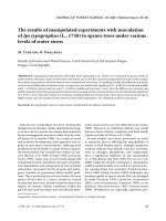
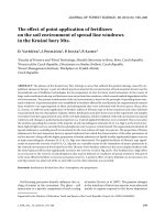
Fig. 1. Percentage values of the
herb synusia cover and levels of
the woody synusia in the years
of repeated surveys. Each survey
year is represented by six boxes.
Horizontal lining – the extent
of recorded covers of the herb
layer, vertical lining – the extent
of total cover of woody plants,
diagonal lining – cover of level
1, grid – cover of level 2, dots
– cover of level 3, zip – cover of
levels 4 and 5
348 J. FOR. SCI., 54, 2008 (8): 340–354
to the abundance of selected woody species, cover
of the individual woody synusia levels, average EIV,
and Shannon-Wiener index separately for woody
and herb synusiae. For this purpose, the unweighted
mean of Ellenberg indicator values (EIV) calculated
by Juice 6.5 was used. e comparison of relevé
scores with the characteristics of the woody synu-
siae suggested which part of the relevé variability
is explained by which ordination axis. e values
of correlation coefficients of relevé scores on the
ordination axes versus herb synusiae characteristics
indicate the impact of the given fact on this part of
phytocoenosis. e degree of statistical significance
was determined by means of F-statistics.
e second level represents changes in the herb
synusia. e shift of the herb synusia composition
over time was studied by CCA in the same way as
described above. To determine the potential vegeta-
tion change relative to soil water content, the co-
ordinates of individual species on the canonical axis
were set out against the respective EIV for moisture.
By fitting the trend curve, the vegetation shift in time
was recorded relative to soil moisture. e mutual
dependence of the Ellenberg indicator value of the
species and the scores of the given species on the
first canonical axis is expressed by the correlation
coefficient. e statistical significance was assessed
using the F-statistics.
A certain complication in the relationship studied
in this way is a difference in the quantity of recorded
species on the same plots in different years of the
survey (Fig. 6), which is sometimes rather large.
Generally, it can be stated that most species are
characterized by a sensitivity value to the given
abiotic factor that is close to the middle of the set
scale. With an increasing number of the species,
the probability of higher occurrence of EIV values
signalling minimal or no relation to the given factor
is also therefore increasing. at means the study
of the phytocoenosis development trends can be
influenced by the changing number of species. e
unweighted arithmetical mean of EIV of the species
in the phytocoenological relevé may also, under
the given circumstances, suppress the information
borne by several more sensitive species. For this
reason, the following method was used for the calcu-
lation of relevé EIV. It counts with the frequency of
occurrence of the indicator value as the valuing fac-
tor for the calculation of the weighted arithmetical
mean of the indicator values of species recorded in
the phytocoenological relevé (S, S
2000). e EIV of relevé herb layers obtained in this
way were used for the comparison of values reached
in the survey years (Fig. 5). e dependence of the
altitude of PRP centres and moisture expressed
through the herb synusia EIV (Figs. 7 and 8) is also
based on the given conversion.
a
j
∑
F
j
I
j
EIV
F
= ––––––––––––––
∑
a
j
F
j
e Ellenberg indicator value of the given relevé
EIV
F
depends on the value of abundance of each
species a
j
, its indicator value I
j
and frequency of the
respective indicator value of the species in the set of
all species recorded within the survey F
j
.
Although the observed floodplain forest commu-
nities grow in the flat broad plain at the confluence of
rivers, they differ especially in the composition of the
herb layers, according to the degree of their being in-
fluenced by the water table height and length of time
when water stagnates once the floods drop. e full-
area surveys including the updating of maps where
the position of standing and fallen trees is indicated
(P 1985; V et al. 2006), which was carried
out using Field Map Technology (www.fieldmap.cz),
enabled to create digital terrain models of the stud-
ied areas. e accurate data of the measured points
(standing tree, ends of fallen trunk, etc.) using stakes
of stable height create a network of points (Ranšpurk
7,294 points, Cahnov-Soutok 4,832 points), which
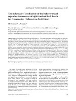
–1.5 1.0
0.3
–0.2
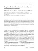
Fig. 2. CCA of woody synusia with the time factor ordinated as a continuous explanatory variable of the environment. Statisti-
cal significance of the canonical axis was verified (P = 0.0002). e presence of trees in lower levels increases over time. e
continuous main level of the forest, characteristic of the primary survey, gradually disintegrates. e number following the
species name stands for the woody synusia layer
1
J. FOR. SCI., 54, 2008 (8): 340–354 349
copy the terrain in a 3D image. e altitude of PRP
centres was read off from terrain models produced
in this way. Mean EIV for relevé herb layers were
projected against them, separately for each year of
the survey. e trend of herb synusia evolution rela-
tive to increasing altitude and time was studied for
both areas separately due to a substantial difference
in the altitudes of the studied reserves. e statistical
significance of differences between the sets of EIV
values for moisture in survey years was analyzed by
one-factor analysis of variance ANOVA.
For the work with phytocoenological data, the
software Turboveg for Windows 2.0 (H,
S 2001) and Juice 6.4 (T 2002)
was used. Ordination analyses were carried out in
Canoco for Windows 4.5 ( B, Š
2002; L, Š 2003) and statistical cal-
culations and their graphical interpretation were
done using specialized software Statistica (StatSoft
2004).
RESULTS
Synusia of woody plants and vertical
structure of the forest over time
In the 1970’s, the woody synusia consisted only
of the highest tree level. e other levels usually
reached less than 10% cover. Since 1994, the onset
of the lowest woody level can be observed, and later
surveys show a gradual filling of the vertical struc-
ture of the forest (Fig. 1). While the presence of tree
species in levels 2–5 increases over time, the pres-
ence and woody cover of level 1 drop. e presence
of most shrub species does not change significantly
over time (Fig. 2). is development is reflected also
in the herb layer. e herb cover is initially on the
same level of total cover as woody plants. Later on,
herbs cover a higher percentage of the forest floor in
the PRP than the disintegrating main tree level, as
well as the entire woody synusia. e herb synusia
reacts to the development of the upper forest levels
with a decrease in its cover (Fig. 1).
e woody synusia in the full structure of the par-
tial levels suggests the scores of the individual relevés
indicated on the DCA axes. ese co-ordinates were
studied in relation to selected characteristics of the
woody synusia and the herb layer (Table 1). e
first axis is characterized by the presence of Juglans
nigra – it was planted only on a small plot within
Ranšpurk. e fourth axis can be characterized in
a similar way; it explains the variability of relevés
from the perspective of Quercus robur presence. Its
decreasing distribution is accompanied by a higher
share of level 3. e third axis creates a boundary
between the two sites. With the increasing share
of Quercus robur in Cahnov-Soutok compared to
Ranšpurk, the share of EIV for the moisture and light
of woody synusia increases. e reaction of the herb
layer to the development of the third ordination axis
is statistically insignificant.
From the viewpoint of changes in phytocoenoses
over the repeated surveys, the second axis is crucial.
It is characterized by increasing diversity in both the
woody and the herb synusia. In relation to the struc-
ture of the forest, it suggests the recession of layer 1
and a significant increase in the lower levels. When
projected onto the herb synusia, the increase in spe-
cies diversity is clear, as well as the decrease in mean
EIV relevés in relation to moisture and light.
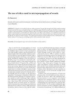
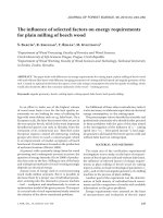
Fig. 3. CCA of herb synusia with the time factor ordinated as a continuous explanatory variable of the environment. Statistical
significance of the canonical axis was verified P = 0.0002. In the diagram, species with higher demands for water content in soil
are usually situated against the direction of time
0.1
–0.2
–1.5 1.0
350 J. FOR. SCI., 54, 2008 (8): 340–354
Changes in the herb synusia
The significant factors influencing the species
composition of the herb layer include the height of
water table, duration of floods, and length of time
when water stagnates at the site after floods recede.
e ordination analysis (Fig. 3) suggests the reces-
sion of water-demanding species in time, and on the
other hand, also an increase in the wood flora species
on sites not influenced by water. e drop in soil
moisture and its reflection in the species composi-
tion of the herb layer are illustrated in Fig. 4.
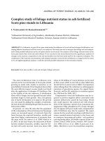
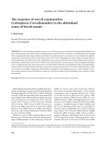
e relation of EIV to the moisture of herbaceous
species and their position within the ordination dia-
gram (Fig. 4) is statistically significant (correlation
coefficient = 0.3; P = 0.003). A decreasing trend is
also visible in the EIV of herb layers of relevés taken
in the sequence of individual survey years (Fig. 5).
e degree of their variance decreases in relation
to higher EIV values. e bottom threshold of the
reached EIV, however, changes only very slightly. e
EIVs of phytocoenological relevés were calculated
for this purpose in order to eliminate the influence of
the varying number of recorded species in the herb
layer in different years of the survey (Fig. 6).
e evolution of the herb layer at the sites shows
internal differences. It depends on the altitude of the
sites and the altitude difference of PRP within the
sites. ese variables have a significant influence on
the water regime at the given micro-site. In Cahnov-
Soutok, the converted EIV values for moisture in
relation to PRP altitude show a similar development
in the individual surveys (Fig. 7). In the given respect,
none of the input EIV value sets represents a statisti-
cally significant deviation.
In Ranšpurk, on the other hand, a decrease of the
EIV values for moisture over time is clearly visible.
e most significant is the difference between the
values from 1974 and 2005 on sites influenced by
water to the greatest extent (Fig. 8). e statistical
–1.0 –0.5 0.0 0.5 1.0 1.5 2.0
10
9
8
7
6
5
4
3
2
EIV – moisture
Species scores on canonical axis
Time
8.0
7.5
7.0
6.5
6.0
5.5
5.0
EIV – moisture
Year
1970 1975 1990 1995 2000 2005
Fig. 5. EIV for the moisture of phy-
tocoenological relevés in the survey
years. e method used to compose
them counted on the frequency of
occurrence of the indicator value as
a weighting factor for the calcula-
tion of weighted arithmetical mean
of the indicator values of species
recorded in the relevé (S,
S 2000)
Fig. 4. e co-ordinates of recorded herb species on the ca-
nonical axis (time) projected against EIV for the moisture of
the given species. e fitting of the resulting field of points
shows a shift in the species composition of the herb layer. e
relation of the species position on the x axis and its EIV for
moisture is statistically significant (correlation coefficient 0.3;
P = 0.002). An increase in the species number recorded over
time is substantial. e more frequent occurrence of species
with the value of EIV for moisture close to the middle of the
assessment scale may significantly influence the development
of the represented trend
J. FOR. SCI., 54, 2008 (8): 340–354 351
significance of the difference in input data was veri-
fied (P = 0.01). Only the surveys carried out in the
years 1994 and 2000 are homogeneous.
DISCUSSION
From the perspective of the studied forests, the
period between 1973 and 2005 can be described as
the time of differentiation of the woody synusia. Its
spontaneous onset can be optically visible already
during the first years after game was fenced out. e
frequently discussed question is the absence of Quer-
cus robur regenerating in a natural way. is fact was
also highlighted by previous research (P 1974;
S, B 1989). Some authors explain this
fact by frequent floods, coming especially in summer
(V 1959; P 1974). Surveys carried out
20 and more years after the regular floods ceased,
however, have never recorded any growing seed-
lings of Quercus robur. e presence of this tree in
lower woody levels therefore remains close to zero.
e presence of Quercus robur in layer 1 could be
explained by its preference by animals grazing in
the forest in the past. e speculations whether and
to what extent the present view of the natural spe-
cies composition of the hardwood floodplain forest
32
30
28
26
24
22
20
18
16
14
12
10
8
Number of species
Year
1970 1975 1990 1995 2000 2005
8.0
7.8
7.6
7.4
7.2
7.0
6.8
6.6
6.4
6.2
6.0
5.8
5.6
5.4
5.2
EIV – moisture
Altitude (m)
151.4 151.5 151.6 151.7 151.8 151.9 152.0 152.1 152.2
Fig. 7. EIV for the moisture of
phytocoenological relevés from
the Cahnov-Soutok site projected
against the altitude of the respec-
tive PRP’s centres. The curves
represent the polynomial fitting of
values from the studied years. Full
line – 1973, dashed line – 1994,
dotted line – 2000, and dash-and-
dot line – 2005. To determine
EIV, the method counted with the
frequency of the indicator value
occurrence as a weighting factor
for the calculation of weighted
arithmetical mean of the indica-
tor values of species recorded in
the relevé (S, S
2000)
Fig. 6. e difference in the number
of recorded species of the herb
layer within PRP in the individual
survey years exceeds the value of
statistical significance (P < 0.001)
352 J. FOR. SCI., 54, 2008 (8): 340–354
should be reviewed or not are still premature. e
species composition of tree regeneration in the stud-
ied plots, however, suggests a substantial reduction
in the share of Quercus robur, at least in the new gen-
eration of the main tree level. On the other hand, the
presence of other species – Acer campestre, Carpinus
betulus, Fraxinus angustifolia subsp. danubialis, and
Tilia cordata in levels 3–5 increases over time. ese
levels nowadays cover most of the forest floor within
the study plots.
The herb synusia, although it lost some of its
total cover, shows an increase in the number of
recorded species. This could be caused by the
climatic development in the respective vegeta-
tion seasons as well as mistakes made by those
who processed the relevés. The increasing trend
in the number of recorded species may, however,
also mean the movement of some of the ecologi-
cal factors. In the case of floodplain forests, one
of the most important factors is the height of the
water table. The changing character of some of the
sites due to its fluctuation may result in increasing
space available for the species of a wider range of
environmental conditions.
Despite the recorded changes in the species com-
position of the aestival aspect, there remains a rela-
tively stable vernal aspect. Species such as Anemone
nemorosa, Corydalis cava, Ficaria calthifolia, or
even Primula veris, Scilla drunensis, and Galanthus
nivalis, which are crucial for the determination of the
association Fraxino-pannonicae-Carpinetum Soó et
Borhidi in Soó 1962, were not recorded during the
survey. e presence of the given phytocoenological
unit in Ranšpurk (V et al. 2000) therefore
cannot be proved.
The assessment of changes in environmental
conditions influencing the given forest communi-
ties is based on the indicator values of the recorded
species relative to the given ecological factors. e
results show that the altitude differences between
PRP are limiting for the differentiation of the sites
within study plots. On the other hand, the speed and
intensity with which the phytocoenosis responds to
the hydrological conditions of the area depend on
the altitude of the locality (Figs. 7 and 8).
Some relations and processes inside the ecosys-
tem were identified through phytoindication (Ta-
ble 1). e geographically non-fitting Juglans nigra
was planted only on one of the “hrudy” hillocks in
Ranšpurk. With its decreasing presence, EIV for
moisture and light in the herb synusia increase. e
reason is the scarce presence of Juglans nigra outside
the area of concentrated plantings in Ranšpurk and
its total absence in damper and lighter Cahnov-Sou-
tok. A decrease in the presence of Quercus robur is
accompanied by massive regeneration of Acer cam-
pestre. e loosening of the canopy due to dying and
fall of some of the large oaks is a condition crucial
for the development of level 3. e increasing EIV
for the light and moisture of the herb layer are prob-
ably caused by the absence of Quercus robur in the
open parts of the dampest segments of the studied
areas. Changes in the forest structure represented
by the second DCA axis are reflected in the herb
synusia through the more intensive shading of the
forest floor. In reaction to this, species requiring
7.8
7.6
7.4
7.2
7.0
6.8
6.6
6.4
6.2
6.0
5.8
5.6
5.4
5.2
EIV – moisture
Altitude (m)
152.6 153.0 153.4 153.8 154.2 154.6
Fig. 8. EIV for the moisture of phy-
tocoenological relevés from the
Ranšpurk site projected against
the altitude of the respective PRPs’
centres. e curves represent the
polynomial fitting of values from
the studied years. Full line – 1973,
dashed line – 1994, dotted line
– 2000, and dash-and-dot line
– 2005. To determine EIV, the
method counted with the fre-
quency of the indicator value oc-
currence as a weighting factor for
the calculation of weighted arith-
metic mean of the indicator values
of species recorded in the relevé
(S, S 2000)
J. FOR. SCI., 54, 2008 (8): 340–354 353
more light tend to recess. e drop in the presence
of species bound to damp areas and increase in the
species diversity correspond with the results of the
other analyses that were carried out.
Referen c e s
ANONYMOUS, 1998. World Reference Base for Soil Re-
sources. ISSS-ISRIC-FAO. World Soil Resources Reports,
84: 1–92.
BRAUN-BLANQUET J., 1964. Pflanzensoziologie. Wien, New
York, Springer Verlag.
DEMEK J. et al., 1987. Zeměpisný lexikon ČSR, Hory a nížiny.
Praha, Academia.
DRIESSEN P., DECKERS J., SPAARGAREN O., NACHTER-
GAELE F., 2001. Lecture notes on the major soils of the
world. World Soil Resources Reports, 94: 1–334.
HEJNÝ S., SLAVÍK B. (eds) et al., 1997. Květena České repub-
liky 1. Praha, Academia.
HENNEKENS S.M., SCHAMINÉE J.H.J., 2001. TURBOVEG,
a comprehensive data base management system for vegeta-
tion data. Journal of Vegetation Science, 12: 589–591.
HORÁK J., 1969. Rezervace lužního lesa na soutoku Moravy
a Dyje. Příloha časopisu Ochrana přírody.
MADĚRA P., 2001. Response of the floodplain forest commu-
nities’ herb layer to changes in the water regime. Biologia
(Bratislava), 56: 63–72.
MEZERA A., 1956. Středoevropské nížinné luhy I. Praha,
ČSAZV, SZN.
MEZERA A., 1958. Středoevropské nížinné luhy II. Praha,
ČSAZV, SZN.
MICHÉLI E., SCHAD P. et al., 2006. World reference base
for soil resources 2006. World Soil Resources Reports,
103: 128.
LEPŠ J., ŠMILAUER P., 2003. Multivariate analysis of ecologi-
cal data using CANOCO. Cambridge, University Press.
PRŮŠA E., 1974. Prales Cahnov. Lesnictví, 20: 731–756.
PRŮŠA E., 1985. Die böhmischen und mährischen Urwälder.
Praha, Academia.
RANDUŠKA D., VOREL J., PLÍVA K., 1986. Fytocenológia
a lesnícka typológia. Bratislava, Príroda.
SCHAFFERS A.P., SÝKORA K.V., 2000. Reliability of Ellenberg
indicator values for moisture, nitrogen and soil reaction: a
comparison with field measurements. Journal of Vegetation
Science, 11: 225–244.
STANĚK T., BARTÁK M., 1989. Strukturální analýza pralesa
Cahnov v ekosystému jihomoravského lužního lesa. Les-
nictví, 35: 507–520.
TER BRAAK C.J.F, ŠMILAUER P., 2002. CANOCO Reference
manual and CanoDraw for Windows Users guide: Software
for Canonical Community Ordination (version 4.5). Ithaca,
Microcomputer Power.
TICHÝ L., 2002. JUICE, software for vegetation classification.
Journal of Vegetation Science, 13: 451–453.
VIEWEGH J., 2002. South-Moravian floodplain forest herb
vegetation in the period 1978–1997. Journal of Forest Sci-
ence, 48: 88–92.
VICHEREK J. et al., 2000. Flóra a vegetace na soutoku Moravy
a Dyje. Brno, Masarykova univerzita.
VRŠKA T., 1997. Prales Cahnov po 21 letech (1973–1994).
Lesnictví-Forestry, 43: 155–180.
VRŠKA T., 1998. Prales Ranšpurk po 21 letech (1973–1994).
Lesnictví-Forestry, 44: 440–453.
VRŠKA T., ADAM D., HORT L., ODEHNALOVÁ P., HO-
RAL D., KRÁL K., 2006. Dynamika vývoje pralesovitých
rezervací v ČR II. Praha, Academia.
VYSKOT M., 1959. Druhová a prostorová skladba Lanž-
hotského pralesa a poměry přirozené obnovy. Lesnictví,
5: 157–174.
ZLATNÍK A., 1953. Fytocenologie lesa. Praha, SPN.
Received for publication February 26, 2008
Accepted after corrections June 3, 2008
Vývoj přirozených lužních lesů na jižní Moravě v období let 1973–2005
ABSTRAKT: Krajina soutoku řek Moravy a Dyje prochází od poloviny 70. let minulého století výraznými změnami
spojenými s poklesem hladiny podzemní vody v důsledku vodohospodářských úprav na obou tocích. I fenomén
periodických jarních záplav patří od ukončení melioračních prací minulosti. Reakce lesních ekosystémů na úbytek
půdní vlhkosti je v práci hodnocena prostřednictvím změn v druhovém složení bylinného patra a známých nároků
jednotlivých zaznamenaných taxonů i celé synuzie bylin na obsah vody v půdě. Výsledky potvrzují, že v čase dochází
k úbytku druhů, které jsou na vodu nejnáročnější. Tendence poklesu Ellenbergových indikačních hodnot bylinného
patra fytocenologických snímků je pozorovatelná i při zohlednění vlivu rozdílného počtu druhů zaznamenaných na
stejných plochách v různých letech šetření. Nejvýraznější změny vykazují nejvlhčí stanoviště, naopak nejstabilnější
jsou vyvýšené polohy, tzv. hrúdy. Intenzita změn vegetace roste přímo úměrně s nadmořskou výškou lokalit. Proces
proměny některých stanovišť vyvolaný změnou vodního režimu je třeba oddělit od opticky snáze pozorovatelných
354 J. FOR. SCI., 54, 2008 (8): 340–354
Corresponding author:
Ing. P U, Výzkumný ústav Silva Taroucy pro krajinu a okrasné zahradnictví, v.v.i., Lidická 25/27,
602 00 Brno, Česká republika
tel.: + 420 541 126 262, fax: + 420 541 246 001, e-mail:
změn porostní struktury. Limitním faktorem jejího rozvoje je v daných podmínkách lesní zvěř. Po vyloučení jejího
vlivu dochází k výškové diferenciaci synuzie dřevin. Kvalitativní posun představuje ústup dříve dominantního
Quercus
robur v hlavní etáži a jeho postupné nahrazování ostatními druhy. Dopady změn probíhajících v synuzii dřevin na
vybrané charakteristiky bylinného patra jsou součástí provedených analýz.
Klíčová slova: lužní les; fytocenóza; synuzie dřevin; synuzie bylin