- Trang chủ >>
- Khoa Học Tự Nhiên >>
- Vật lý
The Earth’s Atmosphere Contents Part 7 doc
Bạn đang xem bản rút gọn của tài liệu. Xem và tải ngay bản đầy đủ của tài liệu tại đây (1.41 MB, 47 trang )
Severe Weather and Doppler Radar
Most of our knowledge about what goes on inside a tor-
nado-generating thunderstorm has been gathered through
the use of Doppler radar. Remember from Chapter 5 that a
radar transmitter sends out microwave pulses and that,
when this energy strikes an object, a small fraction is scat-
tered back to the antenna. Precipitation particles are large
enough to bounce microwaves back to the antenna. As a
consequence, the colorful area on the radar screen in
Fig. 10.35 represents precipitation inside a severe thunder-
storm, as viewed by the older, conventional-type radar.
Notice that the pattern on the left side of the screen is in the
shape of a hook. A hook echo such as this indicates the pos-
sible presence of a tornado. When tornadoes form, they do
so near the tip of the hook. However, there is a problem
here in that many severe thunderstorms (as well as smaller
ones) do not show a hook echo, but still spawn tornadoes.
Sometimes, when the hook echo does appear, the tornado
is already touching the ground. Therefore, a better tech-
282 Chapter 10 Thunderstorms and Tornadoes
Rotating clouds at the base of a
severe thunderstorm often indicate
that the storm is about to give birth
to a tornado. But how do the clouds
develop rotation?
Figure 3 illustrates how rotating
vortices can develop near the
surface. Notice that there is wind
direction shear as surface winds are
southeasterly; aloft they are westerly.
There is also wind speed shear as
the wind speed increases with
increasing height. This wind shear
causes the air near the surface to
rotate about a horizontal axis,
producing narrow tubes of spiraling
air called vortex tubes. A strong
updraft of a thunderstorm may then
tilt a rotating tube and draw it into
the storm as depicted in Fig. 4. This
situation sets up two spinning
vertical columns of air—one rotating
clockwise and the other counter-
clockwise. As air is drawn more
quickly into the storm, the spiraling
columns spin faster.
If the thunderstorm has a more
complicated structure (as most do),
additional rotating air columns may
form. This phenomenon normally
induces the southern flank of the
storm to rotate in one direction, usu-
ally counterclockwise (when viewed
from above) and the northern flank
in the other direction, usually
clockwise. Hence, the thunderstorm
rotates.
FIGURE 3
Spinning vortex tubes created by wind shear.
FIGURE 4
The strong updraft in the thunderstorm carries the vortex tube into the thunderstorm,
producing two rotating air columns that are oriented in the vertical plane.
THUNDERSTORM ROTATION
Focus on an Observation
N
E
S
W
Southeasterly
surface winds
Strong westerly
flow aloft
N
E
S
W
Rotation
clockwise
Updraft
Rotation
counter-
clockwise
nique was needed in detecting tornado-producing storms.
To address this need, Doppler radar was developed.
Doppler radar is like a conventional radar in that it
can detect areas of precipitation and measure rainfall
intensity. But a Doppler radar can do more—it can actu-
ally measure the speed at which precipitation is moving
horizontally toward or away from the radar antenna.
Because precipitation particles are carried by the wind,
Doppler radar can peer into a severe storm and unveil its
winds.
Doppler radar works on the principle that, as pre-
cipitation moves toward or away from the antenna, the
returning radar pulse will change in frequency. A simi-
lar change occurs when the high-pitched sound (high
frequency) of an approaching noise source, such as a
siren or train whistle, becomes lower in pitch (lower fre-
quency) after it passes by the person hearing it. This
change in frequency is called the Doppler shift and this,
of course, is where the Doppler radar gets its name.
A single Doppler radar cannot detect winds that
blow parallel to the antenna. Consequently, two or more
units probing the same thunderstorm are needed to give a
complete three-dimensional picture of the winds within
the storm. To help distinguish the storm’s air motions,
wind velocities can be displayed in color. Color contour-
ing the wind field gives a good picture of the storm.
Even a single Doppler radar can uncover many of the
features of a severe thunderstorm. For example, studies
conducted in the 1970s revealed, for the first time, the
existence of the swirling winds of the mesocyclone inside
tornado-producing thunderstorms. Mesocyclones have a
distinct image (signature) on the radar display. Studies
show that about 30 percent of all mesocyclones produce
tornadoes and about 95 percent produce severe weather.
The time between mesocyclone identification and the tor-
nado actually touching the ground is about 20 minutes.
Tornadoes also have a distinct signature, known as
the tornado vortex signature (TVS), which shows up as a
region of rapidly changing wind directions within the
mesocyclone (see Fig. 10.36). Unfortunately, the resolu-
tion of the Doppler radar is not high enough to measure
actual wind speeds of most tornadoes, whose diameters
Severe Weather and Doppler Radar 283
FIGURE 10.35
A tornado-spawning thunderstorm shows a hook echo in its
rainfall pattern on a conventional radar screen.
FIGURE 10.36
Doppler radar display showing a large supercell thunderstorm
that is spawning an F4 tornado (circled area) near Lula,
Oklahoma. The close packing of the winds indicates strong
cyclonic rotation and the signature of a tornado. (Red and
orange indicate winds blowing away from the radar. Green and
blue indicate winds blowing toward the radar.)
are only a few hundred meters or less. However, a new
and experimental Doppler system—called Doppler
lidar—uses a light beam (instead of microwaves) to
measure the change in frequency of falling precipita-
tion, cloud particles, and dust. Because it uses a shorter
wavelength of radiation, it has a narrower beam and
a higher resolution than does Doppler radar. In an
attempt to obtain tornado wind information at fairly
close range (less than 10 km), smaller portable Doppler
radar units (Doppler on wheels) are peering into tor-
nado-generating storms (see Fig. 10.37).
The new network of 135 Doppler radar units de-
ployed at selected weather stations within the continental
United States is referred to as NEXRAD (an acronym for
NEXt Generation Weather RADar). The NEXRAD system
consists of the WSR-88D* Doppler radar and a set of
computers that perform a variety of functions.
The computers take in data, display it on a moni-
tor, and run computer programs called algorithms,
which, in conjunction with other meteorological data,
detect severe weather phenomena, such as storm cells,
hail, mesocyclones, and tornadoes. Algorithms provide
a great deal of information to the forecasters that allows
them to make better decisions as to which thunder-
storms are most likely to produce severe weather and
possible flash flooding. In addition, they give advanced
and improved warning of an approaching tornado.
More reliable warnings, of course, will cut down on the
number of false alarms.
Because the Doppler radar shows air motions
within a storm, it can help to identify the magnitude of
other severe weather phenomena, such as gust fronts,
microbursts, and wind shears that are dangerous to air-
craft. Certainly, as more and more information from
Doppler radar becomes available, our understanding of
the processes that generate severe thunderstorms and
tornadoes will be enhanced, and hopefully there will be
an even better tornado and severe storm warning sys-
tem, resulting in fewer deaths and injuries.
Waterspouts
A waterspout is a rotating column of air over a large
body of water. The waterspout may be a tornado that
formed over land and then traveled over water. In such a
case, the waterspout is sometimes referred to as a tornadic
waterspout. Waterspouts that form over water, especially
above the warm, shallow coastal waters of the Florida
Keys, where almost 100 occur each month during the
summer, are referred to as “fair weather” waterspouts.†
These waterspouts are generally much smaller than an
average tornado, as they have diameters usually between
3 and 100 meters. Fair weather waterspouts are also less
intense, as their rotating winds are typically less than
45 knots. In addition, they tend to move more slowly
284 Chapter 10 Thunderstorms and Tornadoes
FIGURE 10.37
Graduate students from the University of Oklahoma use a
portable Doppler radar to probe a tornado near Hodges,
Oklahoma.
†“Fair weather” waterspouts may form over any large body of warm water.
Hence, they occur frequently over the Great Lakes in summer.
Storm-chasing scientists on May 3, 1999, using two
Doppler radars mounted on separate vehicles, measured
a record wind speed of 318 mi/hr inside a violent tor-
nado that ultimately ravaged sections of Oklahoma City.
*The name WSR-88D stands for Weather Surveillance Radar, 1988 Doppler.
than tornadoes and they only last for about 10 to 15 min-
utes, although some have existed for up to one hour.
Fair weather waterspouts tend to form when the air
is conditionally unstable and clouds are developing.
Unlike the tornado, they do not need a thunderstorm to
generate them. Some form with small thunderstorms,
but most form with developing cumulus congestus
clouds whose tops are frequently no higher than 3600 m
(12,000 ft) and do not extend to the freezing level.
Apparently, the warm, humid air near the water helps to
create atmospheric instability, and the updraft beneath
the resulting cloud helps initiate uplift of the surface air.
Studies even suggest that gust fronts and converging sea
breezes may play a role in the formation of some of the
waterspouts that form over the Florida Keys.
The waterspout funnel is similar to the tornado
funnel in that both are clouds of condensed water
vapor with converging winds that rise about a central
core. Contrary to popular belief, the waterspout does
not draw water up into its core; however, swirling spray
may be lifted several meters when the waterspout fun-
nel touches the water. Apparently, the most destructive
waterspouts are those that begin as tornadoes over
land, then move over water. A photograph of a particu-
larly well-developed and intense waterspout is shown
in Fig. 10.38.
Summary
In this chapter, we examined thunderstorms and the
atmospheric conditions that produce them. The ingredi-
ents for an isolated ordinary (air-mass) thunderstorm
are humid surface air, plenty of sunlight to heat the
ground, and a conditionally unstable atmosphere. When
these conditions prevail, small cumulus clouds may
grow into towering clouds and thunderstorms within
20 minutes.
When conditions are ripe for thunderstorm devel-
opment and a strong vertical wind shear exists, the stage
is set for the generation of severe thunderstorms. Super-
cell thunderstorms may exist for many hours, as their
updrafts and downdrafts are nearly in balance. Thun-
derstorms that form in a line, along or ahead of an
advancing cold front, are called a squall line.
Lightning is a discharge of electricity that occurs in
mature thunderstorms. The lightning stroke momentar-
ily heats the air to an incredibly high temperature. The
rapidly expanding air produces a sound called thunder.
Along with lightning and thunder, severe thunderstorms
produce violent weather, such as destructive hail, strong
downdrafts, and the most feared of all atmospheric
storms—the tornado.
Tornadoes are rapidly rotating columns of air that
extend downward from the base of a thunderstorm.
Most tornadoes are less than a few hundred meters
wide with wind speeds less than 100 knots, although
violent tornadoes may have wind speeds that exceed
250 knots. A violent tornado may actually have smaller
whirls (suction vortices) rotating within it. With the
aid of Doppler radar, scientists are probing tornado-
spawning thunderstorms, hoping to better predict tor-
nadoes and to better understand where, when, and how
they form.
A normally small and less destructive cousin of the
tornado is the “fair weather” waterspout that com-
monly forms above the warm waters of the Florida Keys
and the Great Lakes in summer.
Summary 285
FIGURE 10.38
A powerful waterspout moves across Lake Tahoe, California.
Key Terms
The following terms are listed in the order they appear in
the text. Define each. Doing so will aid you in reviewing
the material covered in this chapter.
Questions for Review
1. What is a thunderstorm?
2. Describe the stages of development of an ordinary
(air-mass) thunderstorm.
3. How do downdrafts form in thunderstorms?
4. Why do ordinary thunderstorms most frequently
form in the afternoon?
5. What atmospheric conditions are necessary for the
development of an ordinary thunderstorm?
6. (a) What are gust fronts and how do they form?
(b) If a gust front passes, what kind of weather will
you experience?
7. (a) Describe how a microburst forms.
(b) Why is the term wind shear often used in
conjunction with a microburst?
8. Why are severe thunderstorms not very common in
polar latitudes?
9. Give a possible explanation for the generation of pre-
frontal squall-line thunderstorms.
10. What do thunderstorms tend to do when they pro-
duce devastating flash floods?
11. What is a Mesoscale Convective Complex (MCC)?
12. Where does the highest frequency of thunderstorms
occur in the United States? Why there?
13. Why is large hail more common in Kansas than in
Florida?
14. Explain how a cloud-to-ground lightning stroke de-
velops.
15. How is thunder produced?
16. If you see lightning and ten seconds later you hear
thunder, how far away is the lightning stroke?
17. Why is it unwise to seek shelter under a tree during a
thunderstorm?
18. What is a tornado?
19. List the major characteristics of tornadoes, including
their size, wind speed, and direction of movement.
20. How does a tornado watch differ from a tornado
warning?
21. Why is it suggested that one not open windows when
a tornado is approaching?
22. Explain why the central part of the United States is
more susceptible to tornadoes than any other region
of the world.
23. Describe the atmospheric conditions at the surface
and aloft that are necessary for the development of
the majority of tornado-spawning thunderstorms.
24. Describe how Doppler radar measures the winds
inside a severe thunderstorm.
25. Explain both how and why there is a shift in tornado
activity from winter to summer within the continen-
tal United States.
26. What atmospheric conditions lead to the formation
of “fair weather” waterspouts?
Questions for Thought
and Exploration
1. Why does the bottom half of a dissipating thunder-
storm usually “disappear” before the top?
2. Sinking air warms, yet thunderstorm downdrafts are
cold. Why?
3. If you are confronted by a large tornado in an open field
and there is no way that you can outrun it, your only
recourse might be to run and lie down in a depression.
If given the choice, when facing the tornado, would you
run toward your left or toward your right as the tor-
nado approaches? Explain your reasoning.
286 Chapter 10 Thunderstorms and Tornadoes
ordinary (air-mass)
thunderstorms
cumulus stage
mature thunderstorm
dissipating stage
multicell storms
severe thunderstorm
gust front
shelf cloud
roll cloud
downburst
microburst
derecho
supercell storm
squall line
dryline
Mesoscale Convective
Complexes (MCCs)
flash flood
lightning
thunder
sonic boom
stepped leader
return stroke
dart leader
heat lightning
St. Elmo’s Fire
tornadoes
funnel cloud
tornado outbreak
suction vortice
Fujita scale
mesocyclone
gustnado
wall cloud
tornado watch
tornado warning
Doppler radar
NEXRAD
waterspout
4. Use the Severe Weather/Lightning section of the
Blue
Skies CD-ROM
to examine the anatomy of a light-
ning stroke.
5. Using the Severe Weather/Microburst section of the
Blue Skies CD-ROM, try to land a plane while flying
through a microburst.
6. Lightning, sprites, and jets (l
.gov/) Compare photographs of lightning, red sprites,
and blue jets. What similarities can you observe among
these three electrical phenomena? In your own words,
describe the physical mechanism behind sprites and jets.
For additional readings, go to InfoTrac College
Edition, your online library, at:
Questions for Thought and Exploration 287
Tropical Weather
Anatomy of a Hurricane
Hurricane Formation and Dissipation
Hurricane Stages of Development
Hurricane Movement
Focus on a Special Topic:
How Do Hurricanes Compare
with Middle-Latitude Storms?
Destruction and Warning
Focus on a Special Topic:
Modifying Hurricanes
Naming Hurricanes
Summary
Key Terms
Questions for Review
Questions for Thought and Exploration
Contents
O
n September 18, 1926, as a hurricane approached
Miami, Florida, everyone braced themselves for the
devastating high winds and storm surge. Just before dawn the
hurricane struck with full force—torrential rains, flooding, and
easterly winds that gusted to over 100 miles per hour. Then, all
of a sudden, it grew calm and a beautiful sunrise appeared.
People wandered outside to inspect their property for damage.
Some headed for work, and scores of adventurous young people
crossed the long causeway to Miami Beach for the thrill of
swimming in the huge surf. But the lull lasted for less than an
hour. And from the south, ominous black clouds quickly moved
overhead. In what seemed like an instant, hurricane force winds
from the west were pounding the area and pushing water from
Biscayne Bay over the causeway. Many astonished bathers,
unable to swim against the great surge of water, were swept to
their deaths. Hundreds more drowned as Miami Beach virtually
disappeared under the rising wind-driven tide.
Hurricanes
289
B
orn over warm tropical waters and nurtured by a
rich supply of water vapor, the hurricane can
indeed grow into a ferocious storm that generates enor-
mous waves, heavy rains, and winds that may exceed
150 knots. What exactly are hurricanes? How do they
form? And why do they strike the east coast of the United
States more frequently than the west coast? These are
some of the questions we will consider in this chapter.
Tropical Weather
In the broad belt around the earth known as the trop-
ics—the region 23
1
⁄
2
° north and south of the equator—
the weather is much different from that of the middle
latitudes. In the tropics, the noon sun is always high in
the sky, and so diurnal and seasonal changes in tem-
perature are small. The daily heating of the surface
and high humidity favor the development of cumulus
clouds and afternoon thunderstorms. Most of these are
individual thunderstorms that are not severe. Some-
times, however, the storms will align into a narrow band
called a nonsquall cluster. On other occasions, the thun-
derstorms will align into a row of vigorous convective
cells or squall line. The passage of a squall line is usually
noted by a sudden wind gust followed immediately by
a heavy downpour. This deluge is then followed by sev-
eral hours of relatively steady rainfall. Many of these
tropical squall lines are similar to the middle-latitude
squall lines described in Chapter 10.
As it is warm all year long in the tropics, the weather
is not characterized by four seasons which, for the most
part, are determined by temperature variations. Rather,
most of the tropics are marked by seasonal differences in
precipitation. The greatest cloudiness and precipitation
occur during the high-sun period, when the intertropical
convergence zone moves into the region. Even during
the dry season, precipitation can be irregular, as periods
of heavy rain, lasting for several days, may follow an
extremely dry spell.
The winds in the tropics generally blow from the
east, northeast, or southeast—the trade winds. Because
the variation of sea-level pressure is normally quite
small, drawing isobars on a weather map provides little
useful information. Instead of isobars, streamlines that
depict wind flow are drawn. Streamlines are useful
because they show where surface air converges and
diverges. Occasionally, the streamlines will be disturbed
by a weak trough of low pressure called a tropical wave,
or easterly wave (see Fig. 11.1).
Tropical waves have wavelengths on the order of
2500 km (1550 mi) and travel from east to west at
speeds between 10 and 20 knots. Look at Fig. 11.1 and
observe that, on the western side of the trough (heavy
dashed line), where easterly and northeasterly surface
winds diverge, sinking air produces generally fair
weather. On its eastern side, where the southeasterly
winds converge, rising air generates showers and thun-
derstorms. Consequently, the main area of showers
forms behind the trough. Occasionally, a tropical wave
will intensify and grow into a hurricane.
Anatomy of a Hurricane
A hurricane is an intense storm of tropical origin, with
sustained winds exceeding 64 knots (74 mi/hr), which
forms over the warm northern Atlantic and eastern
North Pacific oceans. This same type of storm is given
different names in different regions of the world. In the
western North Pacific, it is called a typhoon, in the
Philippines a baguio (or a typhoon), and in India and
Australia a cyclone. By international agreement, tropical
290 Chapter 11 Hurricanes
10°
20°
30°
°
N
D
iv
e
r
g
e
n
c
e
C
o
n
v
e
r
g
e
n
c
e
Latitude, °N
FIGURE 11.1
A tropical wave (also called an easterly wave) as shown by the
bending of streamlines—lines that show wind flow patterns.
(The heavy dashed line is the axis of the trough.) The wave
moves slowly westward, bringing fair weather on its western
side and showers on its eastern side.
The word hurricane derives from the Taino language of
Central America. The literal translation of the Taino word
hurucan is “god of evil.” The word typhoon comes from
the Chinese word taifung, meaning “big wind.”
cyclone is the general term for all hurricane-type storms
that originate over tropical waters. For simplicity, we
will refer to all of these storms as hurricanes.
Figure 11.2 is a photo of Hurricane Elena situated
over the Gulf of Mexico. The storm is approximately 500
km (310 mi) in diameter, which is about average for hur-
ricanes. The area of broken clouds at the center is its eye.
Elena’s eye is almost 40 km (25 mi) wide. Within the eye,
winds are light and clouds are mainly broken. The sur-
face air pressure is very low, nearly 955 mb (28.20 in.).*
Notice that the clouds align themselves into spiraling
bands (called spiral rain bands) that swirl in toward the
storm’s center, where they wrap themselves around the
eye. Surface winds increase in speed as they blow coun-
terclockwise and inward toward this center. (In the
Anatomy of a Hurricane 291
Rain free area
Eye
Eye wall
Spiral rain band
FIGURE 11.2
Hurricane Elena over the Gulf of Mexico, about 130 km (80 mi) southwest of Apalachicola,
Florida, as photographed from the space shuttle Discovery during September, 1985. Because
this storm is situated north of the equator, surface winds are blowing counterclockwise about
its center (eye). The central pressure of the storm is 955 mb, with sustained winds of 105
knots near its eye.
*An extreme low pressure of 870 mb (25.70 in.) was recorded in Typhoon
Tip during October, 1979, and Hurricane Gilbert had a pressure reading of
888 mb (26.22 in.) during September, 1988.
Southern Hemisphere, the winds blow clockwise around
the center.) Adjacent to the eye is the eye wall, a ring of
intense thunderstorms that whirl around the storm’s
center and extend upward to almost 15 km (49,000 ft)
above sea level. Within the eye wall, we find the heaviest
precipitation and the strongest winds, which, in this
storm, are 105 knots, with peak gusts of 120 knots.
If we were to venture from west to east (left to
right) through the storm in Fig. 11.2, what might we
experience? As we approach the hurricane, the sky
becomes overcast with cirrostratus clouds; barometric
pressure drops slowly at first, then more rapidly as we
move closer to the center. Winds blow from the north
and northwest with ever-increasing speed as we near the
eye. The high winds, which generate huge waves over
10 m (33 ft) high, are accompanied by heavy rain show-
ers. As we move into the eye, the air temperature rises,
winds slacken, rainfall ceases, and the sky brightens, as
middle and high clouds appear overhead. The barome-
ter is now at its lowest point (955 mb), some 50 mb
lower than the pressure measured on the outskirts of the
storm. The brief respite ends as we enter the eastern
region of the eye wall. Here, we are greeted by heavy
rain and strong southerly winds. As we move away from
the eye wall, the pressure rises, the winds diminish, the
heavy rain lets up, and eventually the sky begins to clear.
This brief, imaginary venture raises many unan-
swered questions. Why, for example, is the surface pres-
sure lowest at the center of the storm? And why is the
weather clear almost immediately outside the storm
area? To help us answer such questions, we need to look
at a vertical view, a profile of the hurricane along a slice
that runs directly through its center. A model that
describes such a profile is given in Fig. 11.3.
The model shows that the hurricane is composed
of an organized mass of thunderstorms that are an inte-
gral part of the storm’s circulation. Near the surface,
moist tropical air flows in toward the hurricane’s center.
Adjacent to the eye, this air rises and condenses into
huge thunderstorms that produce heavy rainfall, as
much as 25 cm (10 in.) per hour. Near the top of the
thunderstorms, the relatively dry air, having lost much
of its moisture, begins to flow outward away from the
center. This diverging air aloft actually produces a clock-
wise (anticyclonic) flow of air several hundred kilome-
ters from the eye. As this outflow reaches the storm’s
periphery, it begins to sink and warm, inducing clear
skies. In the vigorous thunderstorms of the eye wall, the
air warms due to the release of large quantities of latent
heat. This warming produces slightly higher pressures
aloft, which initiate downward air motion within the
eye. As the air subsides, it warms by compression. This
process helps to account for the warm air and the
absence of thunderstorms in the center of the storm.
As surface air rushes in toward the region of much
lower surface pressure, it should expand and cool, and
we might expect to observe cooler air around the eye,
with warmer air further away. But, apparently, so much
heat is added to the air from the warm ocean surface
that the surface air temperature remains fairly uniform
throughout the hurricane.
Figure 11.4 is a three-dimensional radar composite
of Hurricane Danny as it sits near the mouth of the
Mississippi River on July 18, 1997. Although Danny is a
weak hurricane, compare its features with those of typical
hurricanes illustrated in Fig. 11.2 and Fig. 11.3. Notice
that the strongest radar echoes (heaviest rain) near the
surface are located in the eye wall, adjacent to the eye.
292 Chapter 11 Hurricanes
500 km
Eye
Outflow
Outflow
15
10
5
0
Altitude (km)
FIGURE 11.3
A model that shows a verti-
cal view of air motions,
clouds, and precipitation in
a typical hurricane.
We are now left with an important question:
Where and how do hurricanes form? Although not
everything is known about their formation, it is known
that certain necessary ingredients are required before a
weak tropical disturbance will develop into a full-
fledged hurricane.
Hurricane Formation and Dissipation
Hurricanes form over tropical waters where the winds are
light, the humidity is high in a deep layer, and the surface
water temperature is warm, typically 26.5°C (80°F) or
greater, over a vast area (see Fig. 11.5). Moreover, the
warm surface water must extend downward to a depth of
about 200 m (600 ft) before hurricane formation is pos-
sible. These conditions usually prevail over the tropical
and subtropical North Atlantic and North Pacific oceans
during the summer and early fall; hence, the hurricane
season normally runs from June through November.
For a mass of unorganized thunderstorms to de-
velop into a hurricane, the surface winds must con-
verge. In the Northern Hemisphere, converging air
spins counterclockwise about an area of surface low
pressure. Because this type of rotation will not develop
on the equator where the Coriolis force is zero (see
Chapter 6), hurricanes form in tropical regions, usually
between 5° and 20° latitude. (In fact, about two-thirds
of all tropical cyclones form between 10° and 20° of the
equator.) Convergence may occur along a preexisting
atmospheric disturbance such as a front that has moved
into the tropics from middle latitudes. Although the
temperature contrast between the air on both sides of
the front is gone, developing thunderstorms and con-
verging surface winds may form, especially when the
front is accompanied by a cold upper-level trough.
Hurricane Formation and Dissipation 293
FIGURE 11.4
A radar composite of Hurricane Danny
showing several features associated with
the storm. The echoes in the composite
are radar echoes that illustrate, in red
and yellow, where the heaviest rain is
falling.
FIGURE 11.5
Hurricanes form over warm tropical waters, where the winds
are light and the humidity, in a deep layer, is high.
We know from Chapter 7 that the surface winds
converge along the intertropical convergence zone
(ITCZ). Occasionally, when a wave forms along the
ITCZ, an area of low pressure develops, convection
becomes organized, and the system grows into a hurri-
cane. Weak convergence also occurs on the eastern side
of a tropical wave, where hurricanes have been known
to form. In fact, many, if not most, Atlantic hurricanes
can be traced to tropical waves that form over Africa.
However, only a small fraction of all of the tropical dis-
turbances that form over the course of a year ever grow
into hurricanes. Studies suggest that major Atlantic
hurricanes are more numerous when the western part
of Africa is relatively wet. Apparently, during the wet
years, tropical waves are stronger, better organized, and
more likely to develop into strong Atlantic hurricanes.
Even when all of the surface conditions appear
near perfect for the formation of a hurricane (e.g.,
warm water, humid air, converging winds, and so
forth), the storm may not develop if the weather condi-
tions aloft are not just right. For example, in the region
of the trade winds and especially near latitude 20°, the
air is often sinking due to the subtropical high. The
sinking air warms and creates an inversion known as
the trade wind inversion. When the inversion is strong
it can inhibit the formation of intense thunderstorms
and hurricanes. Also, hurricanes do not form where the
upper-level winds are strong. Strong winds tend to dis-
rupt the organized pattern of convection and disperse
the heat, which is necessary for the growth of the storm.
This situation of strong winds aloft typically occurs
over the tropical Atlantic during a major El Niño event
(see Chapter 7). As a consequence, during El Niño there
are usually fewer Atlantic hurricanes than normal.
However, the warmer water of El Niño in the northern
tropical Pacific favors the development of hurricanes in
that region. During the cold water episode in the tropi-
cal Pacific (known as La Niña), winds aloft over the
tropical Atlantic usually weaken and become easterly—
a condition that favors hurricane development. At this
point, it is important to note that hurricanes tend to
form where the upper-level winds are diverging (the air
is spreading out) and, at the same time, the air aloft is
leaving a vertical column of air more quickly than the
air at the surface is entering.
The energy for a hurricane comes from the direct
transfer of sensible heat from the warm water into the
atmosphere and from the transfer of latent heat from the
ocean surface. One idea (known as the organized convec-
tion theory) proposes that for hurricanes to form, the
thunderstorms must become organized so that the latent
heat that drives the system can be confined to a limited
area. If thunderstorms start to organize along the ITCZ
or along a tropical wave, and if the trade wind inversion
is weak, the stage may be set for the birth of a hurricane.
The likelihood of hurricane development is enhanced if
the air aloft is unstable. Such instability can be brought
on when a cold upper-level trough from middle latitudes
moves over the storm area. When this situation occurs,
the cumulonimbus clouds are able to build rapidly and
grow into enormous thunderstorms (see Fig. 11.6).
Although the upper air is initially cold, it warms
rapidly due to the huge amount of latent heat released
294 Chapter 11 Hurricanes
Warm, humid air
(a)
Warm
Cold, unstable air
L
H
L
(b)
FIGURE 11.6
Development of a hurricane by the organized convection
theory. (a) Cold air above an organized mass of tropical
thunderstorms generates unstable air and large cumulonimbus
clouds. (b) The release of latent heat warms the upper
troposphere, creating an area of high pressure. Upper-level
winds move outward away from the high. This movement, cou-
pled with the warming of the air layer, causes surface pressures
to drop. As air near the surface moves toward the lower
pressure, it converges, rises, and fuels more thunderstorms.
Soon a chain reaction develops, and a hurricane forms.
The amount of energy released in a hurricane is awe-
some. For example, the latent heat released in a mature
hurricane in one day, if converted to electricity, would be
enough to supply the electrical needs of the United
States for half a year.
during condensation. As this cold air is transformed into
much warmer air, the air pressure in the upper tropo-
sphere above the developing storm rises, producing an
area of high pressure (see Chapter 6, p. 140). Now the air
aloft begins to move outward, away from the region of
developing thunderstorms. This diverging air aloft, cou-
pled with warming of the air layer, causes the surface
pressure to drop, and a small area of surface low pressure
forms. The surface air begins to spin counterclockwise
and in toward the region of low pressure. As it moves
inward, its speed increases, just as ice skaters spin faster as
their arms are brought in close to their bodies. The winds
then generate rough seas, which increase the friction on
the moving air. This increased friction causes the winds
to converge and ascend about the center of the storm.
We now have a chain reaction in progress, or what
meteorologists call a feedback mechanism. The rising air,
having picked up added moisture and warmth from the
choppy sea, fuels more thunderstorms and releases more
heat, which causes the surface pressure to lower even
more. The lower pressure near the center creates a greater
friction, more convergence, more rising air, more thun-
derstorms, more heat, lower surface pressure, stronger
winds, and so on until a full-blown hurricane is born.
As long as the upper-level outflow of air is greater
than the surface inflow, the storm will intensify and the
surface pressure will drop. Because the air pressure within
the system is controlled to a large extent by the warmth of
the air, the storm will intensify only up to a point. The
controlling factors are the temperature of the water and
the release of latent heat. Consequently, when the storm is
literally full of thunderstorms, it will use up just about all
of the available energy, so that air temperature will no
longer rise and pressure will level off. Because there is a
limit to how intense the storm can become, peak wind
gusts seldom exceed 200 knots. When the converging sur-
face air near the center exceeds the outflow at the top, sur-
face pressure begins to increase, and the storm dies out.
An alternative to the organized convection theory
proposes that a hurricane is like a heat engine. In a heat
engine, heat is taken in at a high temperature, converted
into work, then ejected at a low temperature. In a hurri-
cane, small swirling eddies transfer sensible and latent
heat from the ocean surface into the overlying air. The
warmer the water and the greater the wind speed, the
greater the transfer of sensible and latent heat. As the air
sweeps in toward the center of the storm, the rate of
heat transfer increases because the wind speed increases
toward the eye wall. Similarly, the higher wind speeds
cause greater evaporation rates, and the overlying air
becomes nearly saturated.
Near the eye wall, turbulent eddies transfer the
warm moist air upward, where the water vapor con-
denses to form clouds. The release of latent heat inside
the clouds causes the air temperature in the region of
the eye wall to be much higher than the air temperature
at the same altitude further out, away from the storm
center. This situation causes a horizontal pressure gra-
dient aloft that induces the air to move outward, away
from the storm center in the anvils of the cumulonim-
bus clouds. At the top of the storm, heat is lost by clouds
radiating infrared energy to space. Hence, in a hurri-
cane, heat is taken in near the ocean surface, converted
to kinetic energy (energy of motion) or wind, and lost
at its top through radiational cooling.
The maximum strength a hurricane can achieve is
determined by the difference in temperature between the
ocean surface and the top of its clouds. As a consequence,
the warmer the ocean surface, the lower the minimum
pressure of the storm, and the higher its winds. Presently,
there is much debate whether hurricanes are driven by
the organized convection process, by the heat engine
process, or by a combination of the two processes.
If the hurricane remains over warm water, it may
survive for several weeks. However, most hurricanes last
for less than a week; they weaken rapidly when they travel
over colder water and lose their heat source. They also
dissipate rapidly over land. Here, not only is their energy
source removed, but their winds decrease in strength
(due to the added friction) and blow more directly into
the center, causing the central pressure to rise.
As a hurricane approaches land, will it intensify,
maintain its strength, or weaken? This question has
plagued meteorologists for some time. To help with the
answer, forecasters have been using a statistical model
that compares the behavior of the present storm with
that of similar tropical storms in the past. However, the
Hurricane Formation and Dissipation 295
Under the direction of Professor William Gray, scientists
at Colorado State University issue hurricane forecasts.
Their forecasts include the number and intensity of tropi-
cal storms and hurricanes that will develop each hurri-
cane season. Their predictions are based upon such
factors as seasonal rainfall in Africa, upper-level winds,
and sea-level pressure over the tropical Atlantic and the
Caribbean Sea. During the 1990s, they predicted a total
of 104 tropical storms, 63 hurricanes, and 22 intense
hurricanes. The actual numbers were: 108, 64, and 25.
results using this model have not been encouraging.
Another more recent model uses the depth of warm
ocean water in front of the storm’s path to predict the
storm’s behavior. If the reservoir of warm water ahead
of the storm is relatively shallow, ocean waves generated
by the hurricane’s wind turbulently bring deeper, cooler
water to the surface. Studies show that if the water
beneath the eye wall (the region of thunderstorms adja-
cent to the eye) cools by 2.5°C (4.5°F), the storm’s
energy source is cut off, and the hurricane tends to dis-
sipate. Whereas, if a deep layer of warm ocean water
exists, the storm tends to maintain its strength or inten-
sify, as long as other factors remain the same. So, know-
ing the depth of warm surface water is important in pre-
dicting whether a hurricane will intensify or weaken.
Moreover, as new hurricane-prediction models are
implemented, and as our understanding of the nature
of hurricanes increases, improved forecasts of hurricane
movement and intensification should become available.
HURRICANE STAGES OF DEVELOPMENT Hurricanes
go through a set of stages from birth to death. Ini-
tially, the mass of thunderstorms with only a slight
wind circulation is known as a tropical disturbance,
or tropical wave. The tropical disturbance becomes a
tropical depression when the winds increase to
between 20 and 34 knots and several closed isobars
appear about its center on a surface weather map.
When the isobars are packed together and the winds
are between 35 and 64 knots, the tropical depression
becomes a tropical storm. The tropical storm is clas-
sified as a hurricane only when its winds exceed
64 knots (74 miles per hour).
Figure 11.7 shows four tropical systems in various
stages of development. Moving from east to west, we see
a weak tropical disturbance (a tropical wave) crossing
over Panama. Further west, a tropical depression is
organizing around a developing center with winds less
than 25 knots. In a few days, this system will develop
into Hurricane Gilma. Further west is a full-fledged
hurricane with peak winds in excess of 110 knots. The
swirling band of clouds to the northwest is Emilia; once
a hurricane (but now with winds less than 40 knots), it
is rapidly weakening over colder water.
296 Chapter 11 Hurricanes
Tropical storm
Emilia
Hurricane
Tropical
depression
Tropical
disturbance
FIGURE 11.7
Visible satellite
image showing
four tropical
systems, each in a
different stage of
its life cycle.
Brief Review
Before reading the next several sections, here is a review
of some of the important points about hurricanes.
■ Hurricanes are tropical cyclones, comprised of an
organized mass of thunderstorms.
■ Hurricanes have peak winds about a central core
(eye) that exceed 64 knots (74 mi/hr).
■ Hurricanes form over warm tropical waters, where
light surface winds converge, the humidity is high in
a deep layer, and the winds aloft are weak.
■ Hurricanes derive their energy from the warm tropi-
cal water and from the latent heat released as water
vapor condenses into clouds.
■ Hurricanes grow stronger as long as the air aloft moves
outward, away from the storm center more quickly
than the surface air moves in toward the center.
■ Hurricanes dissipate rapidly when they move over
colder water or over a large landmass.
Up to this point, it is probably apparent that trop-
ical cyclones called hurricanes are similar to middle-
latitude cyclones in that, at the surface, both have
central cores of low pressure and winds that spiral
counterclockwise about their respective centers (North-
ern Hemisphere). However, there are many differences
between the two systems, which are described in the
Focus section on p. 298.
HURRICANE MOVEMENT Figure 11.8 shows where
most hurricanes are born and the general direction in
which they move. Notice that they form over tropical
oceans, except in the South Atlantic and in the eastern
South Pacific. The surface water temperatures are too
cold in these areas for their development. It is also pos-
sible that the unfavorable location of the ITCZ during
the Southern Hemisphere’s warm season discourages
their development.
Hurricanes that form over the North Pacific and
North Atlantic are steered by easterly winds and move
west or northwestward at about 10 knots for a week or
so. Gradually, they swing poleward around the subtrop-
ical high, and when they move far enough north, they
become caught in the westerly flow, which curves them
to the north or northeast. In the middle latitudes, the
hurricane’s forward speed normally increases, some-
times to more than 50 knots. The actual path of a hurri-
cane (which appears to be determined by the structure
Hurricane Formation and Dissipation 297
90 180 90 0
Lon
g
itude
60
30
0
30
60
Latitude
60
30
0
30
90
180 90 0
90
90
60
Hurricane
Hurricane
Typhoon
Cyclone
Cyclone
Bangladesh
FIGURE 11.8
Regions where tropical
storms form, the
names given to
storms, and the typical
paths they take.
298 Chapter 11 Hurricanes
By now, it should be apparent that a
hurricane is much different from the
mid-latitude cyclone that we dis-
cussed in Chapter 8. A hurricane
derives its energy from the warm
water and the latent heat of conden-
sation, whereas the mid-latitude
storm derives its energy from hori-
zontal temperature contrasts. The
vertical structure of a hurricane is
such that its central column of air is
warm from the surface upward; con-
sequently, hurricanes are called
warm-core lows. A hurricane weak-
ens with height, and the area of low
pressure at the surface may actually
become an area of high pressure
above 12 km (40,000 ft). Mid-
latitude cyclones, on the other hand,
usually intensify with increasing
height, and a cold upper-level low
or trough exists to the west of the
surface system. A hurricane usually
contains an eye where the air is
sinking, while mid-latitude cyclones
are characterized by centers of
rising air. Hurricane winds are
strongest near the surface, whereas
the strongest winds of the mid-
latitude storm are found aloft in the
jet stream.
Further contrasts can be seen on
a surface weather map. Figure 1
shows Hurricane Allen over the Gulf
of Mexico and a mid-latitude storm
north of New England. Around the
hurricane, the isobars are more
circular, the pressure gradient is
much steeper, and the winds are
stronger. The hurricane has no fronts
and is smaller (although Allen is
larger than most hurricanes). There
are similarities between the two sys-
tems: Both are areas of surface low
pressure, with winds moving
counterclockwise about their respec-
tive centers.
It is interesting to note that some
northeasters (winter storms that move
northeastward along the coastline of
North America, bringing with them
heavy precipitation, high surf, and
strong winds) may actually possess
some of the characteristics of a hurri-
cane. For example, a particularly
powerful northeaster during January,
1989, was observed to have a
cloud-free eye, with surface winds in
excess of 85 knots spinning about a
warm inner core. Moreover, some
polar lows—lows that develop over
polar waters during winter—may
exhibit many of the observed
characteristics of a hurricane, such
as a symmetric band of thunder-
storms spiraling inward around a
cloud-free eye, a warm-core area
of low pressure, and strong winds
near the storm’s center. In fact, when
surface winds within these polar
storms reach 58 knots, they are
sometimes referred to as Arctic
hurricanes.
Even though hurricanes weaken
rapidly as they move inland, their
counterclockwise circulation may
draw in air with contrasting
properties. If the hurricane links with
an upper-level trough, it may
actually become a mid-latitude
cyclone.
HOW DO HURRICANES COMPARE WITH MIDDLE-LATITUDE STORMS?
Focus on a Special Topic
1
0
0
4
1008
1012
1008
1012
1016
1016
1012
1008
1004
1000
1004
1008
1012
L
996
FIGURE 1
Surface weather map for the morning of August 9, 1980, showing Hurricane Allen
over the Gulf of Mexico and a middle-latitude storm system north of New England.
of the storm and the storm’s interaction with the envi-
ronment) may vary considerably. Some take erratic
paths and make odd turns that occasionally catch
weather forecasters by surprise (see Fig. 11.9). There
have been many instances where a storm heading
directly for land suddenly veered away and spared the
region from almost certain disaster. As an example,
Hurricane Elena, with peak winds of 90 knots, moved
northwestward into the Gulf of Mexico on August 29,
1985. It then veered eastward toward the west coast of
Florida. After stalling offshore, it headed northwest.
After weakening, it then moved onshore near Biloxi,
Mississippi, on the morning of September 2.
As we saw in an earlier section, many hurricanes
form off the coast of Mexico over the North Pacific. In
fact, this area usually spawns about eight hurricanes
each year, which is slightly more than the yearly average
of six storms born over the tropical North Atlantic.
Eastern North Pacific hurricanes normally move west-
ward, away from the coast, hence, little is heard about
them. When one does move northwestward, it normally
weakens rapidly over the cool water of the North Pacific.
Occasionally, however, one will curve northward or
even northeastward and slam into Mexico, causing
destructive flooding. Hurricane Tico left 25,000 people
homeless and caused an estimated $66 million in prop-
erty damage after passing over Mazatlán, Mexico, in
October, 1983. The remains of Tico even produced
record rains and flooding in Texas and Oklahoma. Even
less frequently, a hurricane will stray far enough north
to bring summer rains to southern California and Ari-
zona, as did the remains of Hurricane Lester during
August, 1992, and Hurricane Nora during September,
1997. (Nora’s path is shown in Fig. 11.9.)
The Hawaiian Islands, which are situated in the cen-
tral North Pacific between about 20° and 23°N, appear to
be in the direct path of many eastern Pacific hurricanes
and tropical storms. By the time most of these storms
have reached the islands, however, they have weakened
considerably, and pass harmlessly to the south or north-
east. The exceptions were Hurricane Iwa during Novem-
ber, 1982, and Hurricane Iniki during September, 1992.
Iwa lashed part of Hawaii with 100-knot winds and huge
surf, causing an estimated $312 million in damages. Iniki,
the worst hurricane to hit Hawaii in the twentieth cen-
tury, battered the island of Kauai with torrential rain, sus-
tained winds of 114 knots that gusted to 140 knots, and
Hurricane Formation and Dissipation 299
Mitch
1998
Elena
1985
Gordon
1994
Nora
1997
Rosa
1994
Isis
1998
Pauline
1997
FIGURE 11.9
Some erratic paths taken by hurricanes.
Hurricane Tina in 1992 traveled for thousands of miles
over warm, tropical waters and maintained hurricane
force winds for 24 days, making it one of the longest-
lasting North Pacific hurricanes on record.
20-foot waves that crashed over coastal highways. Major
damage was sustained by most of the hotels and about 50
percent of the homes on the island. Iniki (the costliest
hurricane in Hawaiian history with damage estimates of
$1.8 billion) flattened sugar cane fields, destroyed the
macadamia nut crop, injured about 100 people, and
caused at least 7 deaths.
Hurricanes that form over the tropical North
Atlantic also move westward or northwestward on a col-
lision course with Central or North America. Most hur-
ricanes, however, swing away from land and move
northward, parallel to the coastline of the United States.
A few storms, perhaps three per year, move inland,
bringing with them high winds, huge waves, and tor-
rential rain that may last for days. Figure 11.10 is a col-
lection of infrared satellite images of Hurricane
Georges, showing its path from September 18 to Sep-
tember 28, 1998. As Georges moved westward it ravaged
the large Caribbean Islands, causing extensive damage
and taking the lives of more than 350 people. After rak-
ing the Florida Keys with high winds and heavy rain, its
path curved toward the northwest, where it eventually
slammed into Mississippi with torrential rains and
winds exceeding 100 knots. Four people in the United
States died due to Hurricane Georges.
A hurricane moving northward over the Atlantic will
normally survive as a hurricane for a longer time than will
its counterpart at the same latitude over the eastern
Pacific. The reason is, of course, that the surface water of
the Atlantic is much warmer.
DESTRUCTION AND WARNING When a hurricane is
approaching from the east, its highest winds are usually
on its north (poleward) side. The reason for this phe-
nomenon is that the winds that push the storm along
add to the winds on the north side and subtract from
the winds on the south (equator) side. Hence, a hurri-
cane with 110-knot winds moving westward at 10 knots
will have 120-knot winds on its north side and 100-knot
winds on its south side.
The same type of reasoning can be applied to a
northward-moving hurricane. For example, as Hurri-
cane Gloria moved northward along the coast of Vir-
ginia on the morning of September 27, 1985 (see Fig.
11.11), winds of 75 knots were swirling counterclock-
wise about its center. Because the storm was moving
northward at about 25 knots, sustained winds on its
eastern (right) side were about 100 knots, while on its
western (left) side—on the coast—the winds were only
about 50 knots. Even so, these winds were strong
enough to cause significant beach erosion along the
coasts of Maryland, Delaware, and New Jersey.
Even though Hurricane Gloria is moving north-
ward in Fig. 11.11, there is a net transport of water
directed eastward toward the coast. To understand this
behavior, recall from Chapter 7 that as the wind blows
over open water, the water beneath is set in motion. If we
imagine the top layer of water to be broken into a series
of layers, then we find each layer moving to the right
of the layer above. This type of movement (bending) of
water with depth (called the Ekman Spiral) causes a net
300 Chapter 11 Hurricanes
FIGURE 11.10
A composite of infrared satellite images of
Hurricane Georges from September 18 to
September 28, 1998, that shows its
westward trek across the Caribbean, then
northward into the United States.
transport of water (known as Ekman transport) to the
right of the surface wind. Hence, the north wind on
Hurricane Gloria’s left (western) side causes a net trans-
port of water toward the shore. Here, the water piles up
and rapidly inundates the region.
The high winds of a hurricane also generate large
waves, sometimes 10 to 15 m (33 to 49 ft) high. These
waves move outward, away from the storm, in the form
of swells that carry the storm’s energy to distant beaches.
Consequently, the effects of the storm may be felt days
before the hurricane arrives.
Although the hurricane’s high winds inflict a great
deal of damage, it is the huge waves, high seas, and
flooding* that normally cause most of the destruction.
The flooding is due, in part, to winds pushing water
onto the shore and to the heavy rains, which may exceed
25 inches in 24 hours. Flooding is also aided by the low
pressure of the storm. The region of low pressure allows
the ocean level to rise (perhaps half a meter), much like
a soft drink rises up a straw as air is withdrawn. (A drop
of one millibar in air pressure produces a rise of one
centimeter in ocean level.) The combined effect of high
water (which is usually well above the high-tide level),
high winds, and the net transport of water toward the
coast, produces the storm surge—an abnormal rise of
several meters in the ocean level—which inundates low-
lying areas and turns beachfront homes into piles of
splinters (see Fig. 11.12). The storm surge is particularly
damaging when it coincides with normal high tides.
Considerable damage may also occur from hurri-
cane-spawned tornadoes. About one-fourth of the hur-
ricanes that strike the United States produce tornadoes.
The exact mechanism by which these tornadoes form is
not yet known; however, studies suggest that surface
topography may play a role by initiating the conver-
Hurricane Formation and Dissipation 301
N
SC
NC
VA
Max winds:
50 knots
MD
PA
WV
DE
NJ
NY
MA
RI
CT
25 knots
Max winds:
100 knots
FIGURE 11.11
Hurricane Gloria on the morning of September 27, 1985. Mov-
ing northward at 25 knots, Gloria has sustained winds of 100
knots on its right side and 50 knots on its left side. The central
pressure of the storm is about 945 mb (27.91 in.)
FIGURE 11.12
When a storm surge moves in at high tide it can inundate and destroy a wide swath of coastal lowlands.
*Hurricanes may sometimes have a beneficial aspect, in the sense that they
can provide much needed rainfall in drought-stricken areas.
gence (and, hence, rising) of surface air. Moreover, tor-
nadoes tend to form in the right front quadrant of an
advancing hurricane, where vertical wind speed shear is
greatest. Studies also suggest that swathlike areas of
extreme damage once attributed to tornadoes may actu-
ally be due to downbursts associated with the large
thunderstorms around the eye wall. (Because of the
potential destruction and loss of lives that hurricanes
can inflict, attempts have been made to reduce their
winds by seeding them. More on this topic is given in
the Focus section above.)
In examining the extensive damage wrought by
Hurricane Andrew during August, 1992, researchers
theorized that the areas of most severe damage might
have been caused by spin-up vortices (mini-swirls)—
small whirling eddies perhaps 30 to 100 meters in diam-
eter that occur in narrow bands. Lasting for about
10 seconds, the vortices appear to form in a region of
strong wind speed shear in the hurricane’s eye wall,
where the air is rapidly rising. As intense updrafts
stretch the vortices vertically, they shrink horizontally,
which induces them to spin faster (perhaps as fast as
70 knots), much like skaters spin faster as their arms are
pulled inward. When the rotational winds of a vortice
are added to the hurricane’s steady wind, the total wind
speed over a relatively small area may increase substan-
tially. In the case of Hurricane Andrew, isolated wind
speeds may have reached 174 knots (200 mi/hr) over
narrow stretches of south Florida.
With the aid of ship reports, satellites, radar, buoys,
and reconnaissance aircraft, the location and intensity
of hurricanes are pinpointed and their movements care-
fully monitored. When a hurricane poses a direct threat
to an area, a hurricane watch is issued, typically 24 to
48 hours before the storm arrives, by the National Hur-
ricane Center in Miami, Florida, or by the Pacific Hur-
ricane Center in Honolulu, Hawaii. When it appears
that the storm will strike an area within 24 hours, a hur-
ricane warning is issued. Along the east coast of North
America, the warning is accompanied by a probability.
The probability gives the percent chance of the hurri-
cane’s center passing within 105 km (65 mi) of a partic-
ular community. The warning is designed to give resi-
dents ample time to secure property and, if necessary, to
evacuate the area.
A hurricane warning is issued for a rather large
coastal area, usually about 550 km (342 mi) in length.
Since the average swath of hurricane damage is nor-
mally about one-third this length, much of the area is
“overwarned.” As a consequence, many people in a
warning area feel that they are needlessly forced to evac-
uate. The evacuation order is given by local authorities*
and typically only for those low-lying coastal areas
directly affected by the storm surge. People at higher
elevations or further from the coast are not usually
requested to leave, in part because of the added traffic
302 Chapter 11 Hurricanes
Attempts have been made to reduce
a hurricane’s winds by seeding them
with silver iodide. The idea is to
seed the clouds just outside the eye
wall with just enough artificial ice
nuclei so that the latent heat given
off will stimulate cloud growth in this
area of the storm. These clouds,
which grow at the expense of the
eye wall thunderstorms, actually
form a new eye wall farther away
from the hurricane’s center. As the
storm center widens, its pressure
gradient should weaken, which
may cause its spiraling winds to
decrease in speed. During project
STORMFURY, a joint effort of the
National Oceanic and Atmospheric
Administration (NOAA) and the
U.S. Navy, several hurricanes were
seeded by aircraft. In 1963, shortly
after Hurricane Beulah was seeded
with silver iodide, surface pressure
in the eye began to rise and the
region of maximum winds moved
away from the storm’s center. Even
more encouraging results were
obtained from the multiple seeding
of Hurricane Debbie in 1969. After
one day of seeding, Debbie showed
a 30 percent reduction in maximum
winds. However, the question
remains: Would the winds have low-
ered naturally had the storm not
been seeded? One study even casts
doubts upon the theoretical basis for
this kind of hurricane modification
because hurricanes appear to
contain too little supercooled water
and too much natural ice. Conse-
quently, there are many uncertainties
about the effectiveness of seeding
hurricanes in an attempt to reduce
their winds, and all endeavors to
modify hurricanes have been discon-
tinued since the 1970s.
MODIFYING HURRICANES
Focus on a Special Topic
*In the state of New Jersey, the Board of Casinos and the Governor must be
consulted before an evacuation can be ordered.
problems this would create. This issue has engendered
some controversy in the wake of Hurricane Andrew,
since its winds were so devastating over inland south
Florida during August, 1992. The time it takes to com-
plete an evacuation puts a special emphasis on the tim-
ing and accuracy of the warning.
Ample warning by the National Weather Service
probably saved the lives of many people as Hurricane
Allen moved onshore along the south Texas coast during
the morning of August 10, 1980. The storm formed over
the warm tropical Atlantic and moved westward on a
rampage through the Caribbean, where it killed almost
300 people and caused extensive damage. After raking
the Yucatán Peninsula with 150-knot winds, Allen
howled into the warm Gulf of Mexico. It reintensified
and its winds increased to 160 knots. Gale-force winds
reached outward for 320 km (200 mi) north of its center.
As it approached the south Texas coast, it was one of the
greatest storms to ever enter that area. The central pres-
sure of the storm dropped to a low of 899 mb (26.55 in.).
Up until this time, only the 1935 Labor Day storm that
hit the Florida Keys with a pressure of 892 mb (26.35 in.)
was stronger. But Allen’s path became wobbly and it
stalled offshore just long enough to lose much of its
intensity. It moved sluggishly inland on the morning of
August 10. Once it made landfall,
*
it quickly became a
tropical storm with peak winds of less than 50 knots.
In recent years, the annual hurricane death toll in
the United States has averaged between 50 and 100 per-
sons, although over 200 people died in Mexico when
Hurricane Gilbert slammed the Gulf Coast of Mexico
during September, 1988. This relatively low total is
partly due to the advance warning provided by the
National Weather Service and to the fact that only a few
really intense storms have reached land during the past
30 years. However, there is concern that as the popula-
tion density continues to increase in vulnerable coastal
areas, the potential for a hurricane-caused disaster con-
tinues to increase also.
Hurricane Camille (1969) stands out as one of the
most intense hurricanes to reach the coastline of the
United States in recent decades. With a central pressure
of 909 mb, tempestuous winds reaching 160 knots (184
mi/hr), and a storm surge more than 7 m (23 ft) above
the normal high-tide level, Camille unleashed its fury
on Mississippi, destroying thousands of buildings. Dur-
ing its rampage, it caused an estimated $1.5 billion in
property damage and took more than 200 lives.
During September, 1989, Hurricane Hugo was
born as a cluster of thunderstorms became a tropical
depression off the coast of Africa, southeast of the Cape
Verde Islands. The storm grew in intensity, tracked west-
ward for several days, then turned northwestward, strik-
ing the island of St. Croix with sustained winds of
125 knots. After passing over the eastern tip of Puerto
Rico, this large, powerful hurricane took aim at the
coastline of South Carolina. With maximum winds esti-
mated at 120 knots (138 mi/hr), and a central pressure
near 934 mb, Hugo made landfall near Charleston,
South Carolina, about midnight on September 21 (see
Fig. 11.13). The high winds and storm surge, which
ranged between 2.5 and 6 m (8 and 20 ft), hurled a thun-
dering wall of water against the shore. This knocked out
power, flooded streets, and, as can be seen in Fig. 11.14,
caused widespread destruction to coastal communities.
The total damage in the United States attributed to Hugo
was over $7 billion, with a death toll of 21 in the United
States and 49 overall. But Hugo does not even come
close to the costliest hurricane on record —that dubious
distinction goes to Hurricane Andrew.
On August 21, 1992, as tropical storm Andrew
churned westward across the Atlantic it began to
weaken, prompting some forecasters to surmise that
this tropical storm would never grow to hurricane
strength. But Andrew moved into a region favorable for
hurricane development. Even though it was outside the
tropics near latitude 25°N, warm surface water and
weak winds aloft allowed Andrew to intensify rapidly.
And in just two days Andrew’s winds increased from
45 knots to 122 knots, turning an average tropical storm
into one of the most intense hurricanes to strike Florida
this century (see Table 11.1).
With steady winds of 126 knots (145 mi/hr) and a
powerful storm surge, Andrew made landfall south of
Miami on the morning of August 24 (see Fig. 11.15).
The eye of the storm moved over Homestead, Florida.
Andrew’s fierce winds completely devastated the area
(see Fig. 11.16), as 50,000 homes were destroyed, trees
were leveled, and steel-reinforced tie beams weighing
tons were torn free of townhouses and hurled as far as
Hurricane Formation and Dissipation 303
The huge storm surge and high winds of Hurricane
Camille carried several ocean-going ships over 11 km
(7 mi) inland near Pass Christian, Mississippi.
*Landfall is the position along a coast where the center of a hurricane passes
from ocean to land.
several blocks. Swaths of severe damage led scientists to
postulate that peak winds may have approached 174
knots (200 mi/hr). Such winds may have occurred with
spin-up vortices (swirling eddies of air) that added sub-
stantially to the storm’s wind speed. In an instant, a
wind gust of 142 knots (164 mi/hr) blew down a radar
dome and inactivated several satellite dishes on the roof
of the National Hurricane Center in Coral Gables.
Observations reveal that some of Andrew’s destruction
may have been caused by microbursts in the severe
thunderstorms of the eyewall. The hurricane roared
westward across Southern Florida, weakened slightly,
then regained strength over the warm Gulf of Mexico.
Surging northwestward, Andrew slammed into Louis-
iana with 120-knot winds on the evening of August 25.
All told, Hurricane Andrew was the costliest nat-
ural disaster ever to hit the United States. It destroyed or
damaged over 200,000 homes and businesses, left more
than 160,000 people homeless, caused over $30 billion
in damages, and took 53 lives, including 41 in Florida.
Although Andrew may well be the most expensive hur-
ricane on record, it is far from the deadliest.
Before the era of satellites and radar, catastrophic
losses of life had occurred. In 1900, more than 6000
304 Chapter 11 Hurricanes
FIGURE 11.13
A color-enhanced infrared satellite
image of Hurricane Hugo with its
eye over the coast near Charleston,
South Carolina.
FIGURE 11.14
Beach homes at Folly Beach, South Carolina, (a) before and (b) after Hurricane Hugo.
(a) (b)
people lost their lives when a hurricane slammed into
Galveston, Texas, with a huge storm surge (see Table
11.1, below). Most of the deaths occurred in the low-
lying coastal regions as flood waters pushed inland. In
October, 1893, nearly 2000 people perished on the Gulf
Coast of Louisiana as a giant storm surge swept that
region. Spectacular losses are not confined to the Gulf
Coast. Nearly 1000 people lost their lives in Charleston,
Hurricane Formation and Dissipation 305
FIGURE 11.15
A color-enhanced infrared satellite
image shows Hurricane Andrew
moving across south Florida on
the morning of August 24, 1992.
The storm had a central pressure
of 932 mb (27.52 in.) and
sustained winds of 126 knots
(145 mi/hr).
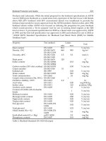
1 Florida (Keys) 1935 892/26.35 5 408
2 Camille 1969 909/26.85 5 256
3 Andrew 1992 922/27.23 4 53
4 Florida (Keys)/South Texas 1919 927/27.37 4 >600*
5 Florida (Lake Okeechobee) 1928 929/27.43 4 1836
6 Donna 1960 930/27.46 4 50
7 Texas (Galveston) 1900 931/27.49 4 >6000
8 Louisiana (Grand Isle) 1909 931/27.49 4 350
9 Louisiana (New Orleans) 1915 931/27.49 4 275
10 Carla 1961 931/27.49 4 46
11 Hugo 1989 934/27.58 4 49
12 Florida (Miami) 1926 935/27.61 4 243
*More than 500 of this total were lost at sea on ships. (The > symbol means “greater than.”)
TABLE 11.1
The Twelve Most Intense Hurricanes (at Landfall) to Strike the United States from 1900 to 1999
Rank Hurricane Year Central Pressure (mb/in.) Category Death Toll
South Carolina, during August of the same year. But
these statistics are small compared to the more than
300,000 lives taken as a killer cyclone and storm surge
ravaged the coast of Bangladesh with flood waters in
1970. Again in April, 1991, a similar cyclone devastated
the area with reported winds of 127 knots and a storm
surge of 7 m (23 ft). In all, the storm destroyed 1.4 mil-
lion houses and killed 140,000 people and 1 million cat-
tle. Unfortunately, the potential for a repeat of this type
of disaster remains high in Bangladesh, as many people
live along the relatively low, wide flood plain that slopes
outward to the bay. And, historically, this region is in a
path frequently taken by tropical cyclones (look back at
Fig. 11.8, p. 297).
Even with modern satellite observation techniques,
hurricane disasters can reach epic proportions. For
example, Hurricane Mitch during late October, 1998,
became the most deadly hurricane to strike the Western
Hemisphere since the Great Hurricane of 1780, which
claimed approximately 22,000 lives in the eastern
Caribbean. Mitch’s high winds, huge waves (estimated
maximum height 44 ft), and torrential rains destroyed
vast regions of coastal Central America (for Mitch’s
path, see Fig. 11.9, p. 299). In the mountainous regions
of Honduras and Nicaragua, rainfall totals from the
storm may have reached 190 cm (75 in.). The heavy
rains produced floods and deep mudslides that swept
away entire villages, including the inhabitants. Mitch
caused over $5 billion in damages, destroyed hundreds
of thousands of homes, and killed over 11,000 people.
More than 3 million people were left homeless or were
otherwise severely affected by this deadly storm.
In an effort to estimate the possible damage a hur-
ricane’s sustained winds and storm surge could do to a
coastal area, the Saffir-Simpson scale was developed
(see Table 11.2). The scale numbers (which range from
1 to 5) are based on actual conditions at some time dur-
306 Chapter 11 Hurricanes
FIGURE 11.16
A community in Homestead, Florida, devastated by Hurricane Andrew on August 26, 1992.
Hurricane Mitch brought an end to the Ghost. On
October 24, 1998, high winds and huge seas gener-
ated by Mitch pounded the majestic 234-foot sailing
vessel Fantome, which in French means “Ghost.” The
captain and a crew of 31 tried in vain to outmaneuver
the monstrous storm, but all were tragically lost as the
$50 million ship sank in a maelstrom of winds and
waves off the coast of Honduras.