GIS Based Studies in the Humanities and Social Sciences - Chpater 7 pptx
Bạn đang xem bản rút gọn của tài liệu. Xem và tải ngay bản đầy đủ của tài liệu tại đây (719.16 KB, 14 trang )
99
7
Data Modeling
of Archaeological Sites Using a
Unified Modeling
Language
Teruko Usui, Susumu Morimoto,
Yoshiyuki Murao and Keiji Shimizu
CONTENTS
7.1 Introduction 99
7.2 Characteristics of Archaeological Information and a Site Survey 100
7.3 Differences between Japanese and European Techniques in Data
Recording and Organizing Archaeological Survey Data 101
7.4 Object-Oriented GIS and an Archaeological-Information
Database 103
7.4.1 Two Kinds of GIS Data Models 103
7.4.2 Standardization of Geographic Information and UML 104
7.4.3 Data Modeling of Archaeological Information and the
General-Feature Model 105
7.5 European Stratigraphic-Sequence Diagrams Using the Harris
Matrix and UML Modeling on Japanese Drawings of
Archaeological Features 108
7.5.1 Class Representing the Archaeological Site
(
Archaeological Site
Class) 108
7.5.2 Drawing of Archaeological Features and
Stratigraphic-Sequence Diagram 109
7.6 Conclusion 111
References 112
7.1 Introduction
This chapter illustrates a data model for archaeological sites that enables
exchange of data among archaeological communities around the world. The
first section describes the nature of archaeological site data. The second
2713_C007.fm Page 99 Thursday, September 15, 2005 6:25 AM
Copyright © 2006 Taylor & Francis Group, LLC
100
GIS-based Studies in the Humanities and Social Sciences
section shows the difference between the Japanese data model and the West-
ern data model (i.e., the Harris Matrix model). The third section discusses
an object-oriented model for recording archaeological site data in compari-
son with the traditional layer-based model. This section also explains the
procedure for this modeling
and a method of implementing it with the
Unified Modeling
Language (UML). The fourth section applies the UML to
both the Japanese data model and the Harris Matrix model. The sixth section
concludes the chapter with remarks on the common data model that can be
shared with researchers throughout the world.
7.2 Characteristics of Archaeological Information and a
Site Survey
Archaeological sites represent evidence of human activities in the past. This
evidence can be classified roughly into two categories: namely,
archaeological
features
and
artifacts
. Postholes and moats are examples of
archaeological fea-
tures
, which exist in a certain location or as a part of the ground, and which
are basically not transferable. Stone tools and earthenware come into the
category of
artifacts,
which are transferable. The place in which artifacts and
remains are excavated is called an
archaeological site
. For archaeologists, it is
the collected information provided by artifacts and remains at archaeological
sites that is the most essential resource to investigate human activities in the
past.
In archaeology, there are various kinds of surveys, such as distribution
surveys, site surveys, trench surveys, and excavation, and the results of those
surveys are finalized in reports. During excavation, it is important to record
precise positional relationships, configuration and position of remains, and
location and direction of artifacts
.
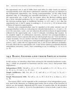
The drawing of archaeological features,
as shown in Figure 7.1, provides spatial information and positional relation-
ship of remains and artifacts in a survey report.
Thus, Geographic Information Systems (GIS) play a significant role in the
management and analysis of archaeological information that contains geo-
graphical information (Wheatley and Gillings, 2002).
However, there is no standardized procedure by which information is
collected, as collection procedures depend on the decisions made by the
excavating archaeologists. Whether to interpret an excavated hole as a pillar
hole or not is dependent on the knowledge of excavation teams. Further-
more, after excavation, the sites are most commonly covered with soil or
building constructions, and the information becomes available only in a
report, with drawings of archaeological features and photos taken. Informa-
tion sharing requires the establishment of standardized recording methods
and a database structure reflecting the least subjective interpretation. Stan-
dardization is required because of the differences in the approach taken by
2713_C007.fm Page 100 Thursday, September 15, 2005 6:25 AM
Copyright © 2006 Taylor & Francis Group, LLC
Data Modeling of Archaeological Sites Using a Unified Modeling Language
101
archaeologists in Japan and Europe in the preservation and recording of
archaeological information.
7.3 Differences between Japanese and European Techniques
in Data Recording and Organizing Archaeological
Survey Data
Survey systems and data-recording techniques are significantly different in
Japan and Europe. In Europe, the differences of stratification are classified
into units of stratification based upon stratigraphy, and each unit of strati-
fication is precisely surveyed with repeated observations of stratigraphic
sequences. Then, the remains are objectively reported in a stratigraphic
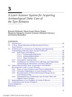
sequence diagram, generally called a Harris Matrix
(Harris, 1989).
Figure 7.2 shows a Harris Matrix diagram. From the aspect of information
recording, it has superiority in the adoption of the minimum unit based on
types of soil, which is least influenced by arbitrary decisions of excavation
teams. The numbering 115 to 153 in Figure 7.2 indicates the relationship of
stratigraphic sequences during excavation. The recording method enables
archaeologists to reproduce excavation processes with possible interpreta-
tions. In contrast, repeat processes are unobtainable after excavation by the
Japanese recording methods shown in Figure 7.1.
FIGURE 7.1
Drawing of archaeological features.
Different drawing
Different drawing
Pileup feature
Plane feature
Cut features
Intrusion
Hachure
Position of finds
Section of excavation area
Relation point between drawings (implicit)
3.5m
X
–
–157050
Y
–
–47505
563
587
589
592
595
590
591
575
594
599
607
610
567
569
586
566
593
597
606
577
3.5m
2713_C007.fm Page 101 Thursday, September 15, 2005 6:25 AM
Copyright © 2006 Taylor & Francis Group, LLC
102
GIS-based Studies in the Humanities and Social Sciences
On the other hand, Japanese archaeologists first identify a feature surface,
which becomes the basis of the survey, and each piece of the remains is
examined based upon geological transitions relative to the feature surface.
The result is reported in the drawing of archaeological features. Compared
to the European stratigraphic technique, objective reporting on remains in
the upper layers is basically left out of the Japanese surveys, because infor-
mation recording is determined on site. In Japan, extensive surveys mostly
take place in a relatively hot and humid environment, and such techniques
enable archaeologists to retain efficiency of surveys and maintain quality.
The boundary of stratification has significant meaning in archaeology, and
its two-dimensional diagram is considered a plainer
representation of
remains. The clarification of the relationship between stratigraphic sequence
diagrams and drawings of archaeological features enables database devel-
opment and integration of archaeological information collected in both Japan
and Europe. Consequently, archaeological information sharing could become
feasible, allowing for the shared use of archaeological information to proceed
worldwide.
For that purpose, we propose that it is critical to articulate the relationship
between the Harris Matrix stratigraphic-sequence diagram and the Japanese
drawing of archaeological features, and to define a schema for an archaeo-
logical-information database to identify the context and structure of archae-
ological information. However, the layer structure in the existing GIS model
has no flexibility to fully incorporate association and definition of archaeo-
logical information. Given that fact, we consider that instead of the layer-
based model, it is beneficial to adapt the feature-based GIS data model to
object-oriented GIS technology — a rapidly advancing technology.
FIGURE 7.2
Harris Matrix’s stratigraphic structure and sequence diagram.
131
141
153
115
115
Boundary surface of stratum
Harris matrix’s stratigraphic sequence diagram
132
Cut feature
Solid of stratum
115 153 Unit of stratification
153
131
132
141
~
2713_C007.fm Page 102 Thursday, September 15, 2005 6:25 AM
Copyright © 2006 Taylor & Francis Group, LLC
Data Modeling of Archaeological Sites Using a Unified Modeling Language
103
7.4 Object-Oriented GIS and an Archaeological-Information
Database
7.4.1 Two Kinds of GIS Data Models
Existing GIS has a database structure derived from paper maps, which
require overlaying of several outlines, showing such features as buildings,
roads, and administrative boundaries. In a similar way, GIS adopts the
same layer structure, and geographic spaces are represented with the over-
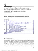
lay technique. As shown in Figure 7.3, general database structure supports
layers consisting of geometric and attribute databases, ensuring the col-
lated data is merged and combined in a spatial index. The layer-based data
model has an interlayering relationship problem, which can be significant.
For instance, in the electricity-management system, electric line (line),
power pole (point), and power plant (polygon) layers are created and
manipulated in electricity flow and facilities. In this layer-based data
model, realistic situations often occur. For example, the electricity line
remains even if a particular pole in the layer is erased. Since the mid-1980s,
a more robust, feature-based data model has been operational, superseding
the layer-based data model (Tang et al., 1996). This development has been
accelerated by the object-oriented, technological advance leading to the
standardization of geographical information by the International Organi-
zation for Standardization (ISO) Technical Committee (TC 211, Geographic
FIGURE 7.3
The structure of a layer-based data model.
Attribute table
ID
ID = 1
Telegraph pole
(point)
Power line
(line)
Power station
(polygon)
ID = 1
ID = 1
1
ID
1
ID
1
2713_C007.fm Page 103 Thursday, September 15, 2005 6:25 AM
Copyright © 2006 Taylor & Francis Group, LLC
104
GIS-based Studies in the Humanities and Social Sciences
information/Geomatics). The feature-based data model has been influ-
enced by the object-oriented GIS technology.
Figure 7.4 shows the differences between feature-based and layer-based
models in the process of defining database structure or schema. The layer-
based model generates layers consisting of geometric database and attribute
database. On the other hand, the development of the database structure or
schema of the feature-based model involves defining the feature type fol-
lowed by the relationships between each type. For example, in the electricity-
management system, the features of power pole, electric line, and power
plant are identified, followed by the relationships between the features.
Eventually, a database schema is defined by itself with the definitions. It is
the geographic information standards that set such feature definitions and
the rules of relationships between features. This is the first step in defining
archaeological features based on geographic-information standards to
develop a database structure of archaeological information.
7.4.2 Standardization of Geographic Information and UML
The purpose of standardizing geographic information is the implementation
of information sharing and its interoperability. In the area of object-based GIS,
standardization does not simply imply integration of data formats. Specifically,
FIGURE 7.4
The application schema of a feature-based data model.
Power supply
Name: String
Network facility
ID: Integer
Telegraph pole
ID: Integer
Shape: GM_Point
Power line
ID: Integer
Shape: GM line
Power station
ID: Integer
Name: String
2713_C007.fm Page 104 Thursday, September 15, 2005 6:25 AM
Copyright © 2006 Taylor & Francis Group, LLC
Data Modeling of Archaeological Sites Using a Unified Modeling Language
105
it defines the attributes, operations, and associations of physical features, such
as roads, buildings, and archaeological sites. Their semantic attributes and
operations are encapsulated into feature classes, such as roads, and the imple-
mentation of common rules that enable the sharing and mutual utilization of
the information. The technique of defining feature classes and class relation-
ships in geographic information is called
data modeling
. In the standardization
of geographic information, common rules for data modeling
are specified with
a special language called
Unified Modeling
Language
(UML).
Following ISO/TC211, UML, a language for object-based technique, is rec-
ognized as the conceptual schema language for standardizing geographic
information. UML was originally developed by Grady Booch, Ivar Jacobson,
and James Rumbaugh of the Rational Software Corp. in the United States and
introduced as
Object-Modeling Technique
(OMT), a technique that uses diagram
representations. Version 1.1 was certified as a standard language of the Object
Management Group (OMG) in November 1997. Unlike other object-oriented
languages, such as C
++
and Java, the UML is a visual-modeling
language
depicting a diagram to define objects and identify any relationships among
them. At the same time, it enables the creation of a metamodel integrating
notations and semantics (Worboys, 1994). This chapter introduces the research
findings in the data modeling
of archaeological information with the aim of
effective information sharing and utilization in the field of archaeology. The
modeling
was conducted based upon the geographic-information standards
defined by ISO/TC211.
The organizational head office of ISO/TC211 (www.isotc211/) is currently
located in Norway, and its Japanese contact for the standardization of geo-
graphic information is at the Geographical Survey Institute (GSI). In 1999,
the GSI produced the Japanese Standards for Geographical Information 1.0
(JSGI 1.0), which was the result of a public–private, collaborative research
partnership that began in 1996. In 2002, the GSI released the second version
of the JSGI on the Internet.
7.4.3 Data Modeling
of Archaeological Information and the General-
Feature Model
Geographic-information standards have a characteristic in defining the struc-
ture of the GIS database with a conceptual model generating real-world
abstraction. This conceptual model is the
General-Feature Model
(GFM). Figure
7.5 provides a clear picture of the Domain Reference Model, consisting of
four levels, including the GFM. Ancient remains are classified into features,
and a
Feature Catalogue
, called the “Feature Dictionary,” is created to clearly
define the features. An application schema is developed using the UML for
digitization of the features. A diagram is represented in UML as a schema,
which provides the framework and content of archaeological information to
be stored in a computer.
2713_C007.fm Page 105 Thursday, September 15, 2005 6:25 AM
Copyright © 2006 Taylor & Francis Group, LLC
106
GIS-based Studies in the Humanities and Social Sciences
In cognitive linguistics,
discourse
means language communication. In fact,
the world in which human beings are engaged in language communication is
considered the universe of discourse. In short, the universe of discourse means
the real world in which entities and phenomena are understood and explained
by language. The objects derived from the processes of abstraction and clas-
sification of entities and phenomena are called
features
. The world in which
we communicate about ancient remains represents the universe of discourse
on ancient remains. Such communication is established by use of universal
meanings; in this case, technical terms in archaeology. We human beings
understand ancient remains in dictionary form, and for information sharing
in GIS, it is essential to generate the feature catalogue of archaeological infor-
mation and have the meanings and structure understood through the dictio-
nary. The key point is that the dictionary should be usable on a computer. To
that end, archaeological features are defined by the UML so that an application
schema, the structure of the database, is consequently determined (Peckham
and Lloyd, 2003).
FIGURE 7.5
Domain reference model in a general feature model.
General feature model
Perception
cognition
Real world
phenomena
Universe of
discourse
Feature catalogue
UML
application schema
Data level
2713_C007.fm Page 106 Thursday, September 15, 2005 6:25 AM
Copyright © 2006 Taylor & Francis Group, LLC
Data Modeling of Archaeological Sites Using a Unified Modeling Language
107
The Domain Reference Model (DRM), shown in Figure 7.5, indicates the
basis of archaeological data modeling. The DRM consists of four distinct
levels.
1. The first level is the conceptual model, which extracts the universe
of discourse on ancient remains from the real world.
2. The second level is the GFM, which abstracts the archaeological
features and then creates a catalogue of archaeological information.
3. The third level is the application schema, which depicts the content
and framework of archaeological information using the UML.
4. Finally, the data level implements geometric and topological spatial
objects as specific spatial datasets. In this level, the data are encoded
using XML (Usui, 2003).
In Japanese archaeological surveys, once a survey is completed, the
remains are returned to their original state. Meanwhile, excavated artifacts
are removed and kept in a separate place. Since the information on positional
relationships of artifacts and remains are lost after the survey, a report
becomes invaluable as the only information for archaeologists. Moreover,
given that the survey involves excavating multiple soil layers, the remains
in the upper soil layers need to be removed to reach those in the lower layers.
Thus, the downward excavating process suggests that the remains found in
the upper soil layers could not be restored to their original form. For this
reason, a survey report and drawing of archaeological features must contain
all the necessary information, especially the drawing of archaeological infor-
mation, which would be required to define the archaeological features.
The geographic-information standards of ISO 19109, Rules for Application
Schema, specify the way to define objects and the spatial relationship
between features. This gives the impression that the standards provide spe-
cific methods for defining objects, but this is not so. In fact, the ISO 19109
Rules for Application Schema employs the UML to define objects, thus
enabling the integration of general-information systems and GIS. Moreover,
with the application of geographic-information standards, the defining pro-
cesses of archaeological feature shapes and time attributes become simple.
Both the Spatial Schema — defined by ISO 19107 — and the Temporal
Schema — defined by ISO 19108 — form shape and time components or
classes in the model, respectively.
Time is a critical element in archaeological information. The data may give
a clue to a specific calendar year or a certain era; or, in some cases, no
identifiable information at all. By applying these standards to archaeological
information, it became feasible to make use of time-defining methods in
addition to spatial information. Table 7.1 introduces object data types defined
in ISO 19107 Spatial Schema and ISO 19108 Temporal Schema.
2713_C007.fm Page 107 Thursday, September 15, 2005 6:25 AM
Copyright © 2006 Taylor & Francis Group, LLC
108
GIS-based Studies in the Humanities and Social Sciences
7.5 European Stratigraphic-Sequence Diagrams Using the
Harris Matrix and UML Modeling
on Japanese Drawings
of Archaeological Features
7.5.1 Class Representing the Archaeological Site (
Archaeological Site
Class)
The core pieces of information from archaeological sites are archaeological
features and finds that are collected during a survey and recorded in a survey
report. The report contains drawings of archaeological features, and maps
indicating the most critical findings, such as shape, location, direction, and
relative position of archaeological features. All the spatial attributes are
provided in the drawings of archaeological features. Thus, in Japan, to com-
pile a database, modeling
becomes critical to accomplishing information
sharing.
Figure 7.6 shows the definitions of an archaeological site class in a UML
diagram. The class representing archaeological sites is the most significant
in explaining the whole archaeological site. There are seven archaeological
class attributes: identification number (identifierOfSite), name (nameOfSite),
address (addressOfSite), duration (periodOfSite), area (archaeologicalArea),
descriptions, and other information (additionalAttribute). In addition, there
is a site-owner class (LandOwner), administrator class (AdministratorOf-
Site), survey-finding class (ResultOfInvestigation), and structure class (Strati-
graphicStructure). The archaeological site class and those four classes are
parts of the whole. The relationship between these classes is considered
“composition,” since the components are all deleted in the case of taking out
the whole archaeological site. In the figure, the class relations are drawn in
filled rhombus.
In Japanese archaeological surveys, research findings (ResultOfInvestiga-
tion class) are completed with drawings of archaeological features; on the
other hand, in the case of overseas surveys, stratigraphic-sequence diagrams
TABLE 7.1
Major Data Types of the Geographic Information Standards
Data Type Representation
GM_Point Spatial location (point)
GM_Curve Spatial curve line
GM_Surface Spatial curved surface
TM_Instant Temporal position (time)
TM_Period Temporal line (period)
Character String Nearly identical to string type and character set addressable
2713_C007.fm Page 108 Thursday, September 15, 2005 6:25 AM
Copyright © 2006 Taylor & Francis Group, LLC
Data Modeling of Archaeological Sites Using a Unified Modeling Language
109
are produced. The diagrams depict the lowest-level configuration of strati-
graphic structure (StratigraphicStructure class). The data types of the geo-
graphic-information standards, shown in Table 7.1, are applied to the
archaeological-site properties. The data type of duration (periodOfSite) is
the same as TM_Period. The duration of archaeological sites can be identified
in a calendar year in some cases; in other cases, only its period can be
estimated. The data types enable us to suggest the Jurassic and Cretaceous
periods, which provide uncertain time periods, with no specific beginning
and end years, in addition to the Gregorian and Japanese calendars. The
archaeological sites certainly have addresses (addressOfSite), and basic infor-
mation is recorded in the section. To provide precise location information of
archaeological sites, GM_Surface, a data type of the geographic-information
standards, is used.
7.5.2 Drawing of Archaeological Features and Stratigraphic-Sequence
Diagram
Figure 7.7 explains the relationship between the drawings of archaeological
features developed in Japanese archaeological surveys and the stratigraphic-
sequence diagram, or Harris Matrix, of the European surveys. The archaeo-
logical-site class is made of aggregation of multiple soil stratifications. As a
result, an attribute StratigraphicStructure class is used to describe the strati-
graphical structures. This class also has components of SolidOfStratum class,
indicating configuration of each stratigraphy, and BoundarySurfaceOfStra-
tum, expressing the boundary surface of the stratum. UnitOfStratification
class, a component of the Harris Matrix stratigraphic sequence diagram class,
FIGURE 7.6
UML diagram of an archaeological site.
2713_C007.fm Page 109 Thursday, September 15, 2005 6:25 AM
Copyright © 2006 Taylor & Francis Group, LLC
110
GIS-based Studies in the Humanities and Social Sciences
has association with SolidOfStratum class and BoundarySurfaceOfStratum
class. On the contrary, the drawing of archaeological features is a projection
of the boundary surface of the stratum. The class of BoundarySurfaceOfStra-
tum can define the relationship between two systems: the drawing of archae-
ological features and the stratigraphic-sequence diagram.
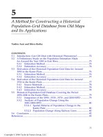
The drawing of archaeological features plays a critical role in archaeolog-
ical surveys. The representation of the drawings is the DrawingOfArchaeo-
logicalFeatures class, which is defined in Figure 7.8. The class represents the
entire survey findings, which consist of ground plan, cross-section, and side
view. As introduced in Figure 7.1, the contents of the drawing of archaeo-
logical features are categorized into the figures of archaeological feature,
excavation area, intrusion, declaration, and reference point, and they have
the relationship of aggregation. The most significant element in the drawing
of archaeological features is an ArchaeologicalFeature class. This class
enables us to classify whether it has a dent, swell, or plane surface relative
to the boundary surface of the stratum. Each condition is named as an
archaeological cut feature, archaeological pile-up feature, and archaeological
plane feature.
FIGURE 7.7
Relationships between Japanese drawings of archaeological features and the European Harris
Matrix stratigraphic Sequence diagram.
Drawing of archaeological features
Results of investigation
Archaeological site
Stratigraphic structure
Boundary surface of stratum
Solid of stratum
Stratigraphic sequence diagram
Unit of stratification
2713_C007.fm Page 110 Thursday, September 15, 2005 6:25 AM
Copyright © 2006 Taylor & Francis Group, LLC
Data Modeling of Archaeological Sites Using a Unified Modeling Language
111
7.6 Conclusion
For the worldwide implementation of archaeological information sharing, it
is necessary to compare various information contexts and structures by
countries and organize them based on specific rules. The object-oriented GIS
have the rules of the geographic-information standards. Features can be
defined by the UML so that the definitions of database schema become
attainable. Unlike existing GIS, the object-oriented GIS provides the feature
objects in geographic information, which are the smallest units consisting of
geographic spaces, and treat them as if they are components of engineering
products. The geographic-information standards can be considered as rules
defining feature standards. This chapter has described the database-produc-
tion process of archaeological information that meets the geographic-infor-
mation standards. The features consisting of archaeological information are
classified into two major classes: ArchaeologicalSite class, which is at the
upper level; and ArchaeologicalFeature class, which can be subclassified into
archaeological cut, archaeological pile-up, archaeological plane, and soil-
layer classes, as shown in Figure 7.1. The ArchaeologicalFeature class corre-
sponds to the boundary surface of the stratum in the Harris Matrix, and it
FIGURE 7.8
UML diagram of Archaeological Feature class.
<< abstract >>
+description[0 1] : CharacterStrin
g
+additionalAttribute[0 *] : AdditionalAttributeValue
Archaeological feature
1 *
Drawing of archaeological features
+dateOfContent[0 1] : TM_Instant
0 * + fi
g
ure of archaeolo
g
ical feature
+element feature
Fi
g
ure of archaeolo
g
ical feature
Position of finds
Position of specimen
Additional line in drawing of features
Group of archaeological features
2713_C007.fm Page 111 Thursday, September 15, 2005 6:25 AM
Copyright © 2006 Taylor & Francis Group, LLC
112
GIS-based Studies in the Humanities and Social Sciences
enables the management and searching of a single database containing
archaeological information collected in Japan, Britain, and the U.S.A. The
object-oriented GIS assume features as the component units in geographic
spaces and achieve data sharing by creating a feature catalogue based on
the rules. In fact, the recognition process adapted to GIS in this chapter is
similar to that used by human beings to understand the meanings of phe-
nomena through dictionaries.
References
Wheatley, D. and Gillings, M.,
Spatial Technology and Archaeology: The Archaeological
Applications of GIS
, Taylor & Francis, London, 2002.
Harris, E.C.,
Principles of Archaeological Stratigraphy
, 2nd ed., Academic Press, London,
1989.
Tang, A.Y., Adams, T.M., and Usery, E.L., A spatial data model design for feature-
based geographical information systems,
Int. J. Geogr. Info. Syst.,
10(5), 643–659,
1996.
Worboys, M.F., Object-oriented approaches to geo-referenced information.
Int. J.
Geogr. Info. Syst
, 8(4), 385–399, 1994.
Peckham, J. and Lloyd, S.J., Eds.,
Practicing Software Engineering in the 21st Century
,
IRM Press, Hershey, 2003.
Usui, T., GIS revolution and geography — object oriented GIS and the methodology
of chorography,
Geogr. Rev. Jpn.,
76(10), 687–702, 2003.
2713_C007.fm Page 112 Thursday, September 15, 2005 6:25 AM
Copyright © 2006 Taylor & Francis Group, LLC