GIS for SUSTAINABLE DEVELOPMENT - PART 2 docx
Bạn đang xem bản rút gọn của tài liệu. Xem và tải ngay bản đầy đủ của tài liệu tại đây (11.63 MB, 201 trang )
Part II
GIS Research Perspectives
for Sustainable
Development Planning
© 2006 by Taylor & Francis Group, LLC
107
7
Advanced Remote
Sensing Techniques
for Ecosystem Data
Collection
Alexandr A. Napryushkin and Eugenia V.
Vertinskaya
CONTENTS
7.1 Introduction 107
7.2 RS-Based Thematic Mapping Methodology 109
7.2.1 General Concept 109
7.2.2 Imagery Interpretation Approach 111
7.3 Thematic Mapping Methodology Implementation 114
7.3.1 The RS Imagery Processing and Interpretation System
“LandMapper” 114
7.3.2 Application of “LandMapper” for Anthropogenic
Ecosystems Research 116
7.3.2.1 Mapping Hydro Network and Urban Areas
of Tomsk City 116
7.3.2.2 Landscape-Ecological Research of Pervomayskoe
Oil Field 118
7.4 Conclusion 121
Acknowledgments 122
References 122
7.1 INTRODUCTION
The problems of monitoring and ecological control of ecosystems of different natures
are becoming more and more urgent. Monitoring of the Earth’s surface has a mul-
tidisciplinary character and allows a wide spectrum of issues to be solved. The
ecosystem components involved in monitoring are manifold and include, among others,
surface waters, soils, vegetation canopy, and anthropogenic landscape components. The
latter represent the man-made and man-changed ecosystems and are of primary interest
© 2006 by Taylor & Francis Group, LLC
108 GIS for Sustainable Development
in the context of monitoring and management problems due to degradation of recent
ecological conditions [1].
One of the most important issues solved in the monitoring process is represen-
tation of its results as a series of thematic maps indicating the spatial structure of
complex ecosystem components [2]. The basic concern of thematic mapping is
graphical modeling of ecosystems and providing the information on their conditions
for efficient natural resources management. The geoinformation provided by the
thematic maps is used for analysis and assessment of natural resource conditions,
recording and accounting destructive natural phenomena, studying natural and man-
made ecosystems interaction, revealing anthropogenic impact to environment, and
assessing its consequences [1,3].
Initial information used for ecosystems thematic mapping is acquired by means
of terrestrial and remote monitoring techniques. The former characterize only 1 to
5% of surface and are not efficient to provide sufficient information on large eco-
systems. Moreover, when detailed research is conducted, personnel, equipment, and
time costs increase dramatically. Remote monitoring techniques provide a number
of advantages over the terrestrial techniques, allowing the limitations of the latter
to be overcome. In the literature, the concept of remote monitoring or surveying is
referred to as remote sensing (RS) [4]. The RS techniques involve detecting and
measuring electromagnetic radiation or force fields associated with terrestrial objects
located beyond the immediate vicinity of recording instruments, such as radiometers
or radar systems mounted on an aircraft or satellite. Remote monitoring, unlike the
terrestrial one, allows a large-scale ecosystem to be surveyed with a short repeat
cycle. The latter in most cases is a crucial criterion for ecosystem-change research.
Generally, RS data represent images much like photos of the sensed surfaces of the
objects under surveillance, and in the literature, RS images are often referred to as
aerospace imagery [5].
Recently, thematic mapping of ecosystems has been widely implemented
through employing geographic information systems (GIS) characterized by advanced
capabilities for spatial information storing, manipulating, and processing [6]. Modern
GIS provide wide capabilities for both computer-aided thematic mapping and spatial
analysis of mapped features and phenomena, allowing derivation of complex quan-
titative characteristics indispensable for ecosystem conditions modeling and fore-
casting. Commonly, GIS facilities are oriented mainly for vector data handling, while
RS-based thematic mapping methodology requires supporting functions of raster
image processing. This fact makes urgent the problem of developing efficient and
highly integrated software means enabling GIS to implement aerospace imagery
processing and facilitate the thematic mapping technologies with use of RS data.
In this chapter, the methodology of RS-based thematic mapping is introduced.
The implementation of the methodology is based on application of a vector GIS and
original image processing and interpretation system “LandMapper” [7], developed
at Tomsk Polytechnic University (TPU). The main distinction of the system from
its counterparts is adaptive classification procedure (ACP), making the process of
image interpretation more flexible and efficient in comparison with existing recog-
nition techniques. The chapter considers the basic methodology of image processing
and interpretation adopted in the “LandMapper” system and gives the results of its
© 2006 by Taylor & Francis Group, LLC
Advanced Remote Sensing Techniques for Ecosystem Data Collection 109
application for solving problems of mapping two anthropogenic ecosystems with
the use of multispectral imagery acquired from the Russian satellite RESURS-O1.
7.2 RS-BASED THEMATIC MAPPING METHODOLOGY
7.2.1 G
ENERAL
C
ONCEPT
Today, thematic mapping technologies making use of RS monitoring data and mod-
ern GIS-based tools are of great value, especially when significant interest is taken
in research of various aspects of anthropogenic ecosystems. The wide range of
anthropogenic issues that can be solved by means of RS-based thematic mapping
involve urban areas monitoring [2], land use mapping, anthropogenic load of petro-
leum-production territories assessment, snow cover surveying, and flood forecasting.
Recently joint use of GIS and thematic maps designed with aerospace imagery
proved to be an efficient approach to creating and employing comprehensive models
of anthropogenic ecosystems that were indispensable for decision-making.
Designing thematic maps with the use of RS imagery consists of a number of
steps, including complicated processing of initial imagery, and is, as a rule, a
nontrivial task to accomplish. Figure 7.1 illustrates the general scheme of thematic
mapping of landscape ecosystems with use of remotely sensed images. According
to Figure 7.1, in the methodology of RS-based thematic mapping, the stages of
preliminary and thematic processing of imagery may be distinguished.
FIGURE 7.1 Thematic mapping with use of remotely sensed imagery.
Imagery preliminary processing
Receiving ground station
(imagery archive)
Orbital segment
Imagery thematic processing
GIS analysis
Radiometric and geometric
corrections
Rectification and georeferencing
Interpretation
Conversion of raster thematic
classes into vector features
Spatial analysis and
quantitative estimation
Forecasting and decision makingGIS modeling
Radiochannel
Imagery
Rectified and
georeferenced
imagery
Thematic maps
Ancillary geoinformation
Sample data
© 2006 by Taylor & Francis Group, LLC
110 GIS for Sustainable Development
Initially, imagery acquired from a satellite or aircraft is exposed to multilevel
preliminary processing in order to make it usable for comprehensive analysis and
facilitate transition from a simple raster image to a complex thematic map model.
The preliminary processing involves solving the tasks of geometric and radiometric
error correction. The tasks include compensation of radiometric distortion caused
by atmospheric effect and instrumentation errors, correction of geometric distortion
due to the earth curvature, rotation, and panoramic effect, noise reduction, image
registration in a geographical coordinate system (georeferencing) through its recti-
fication, and visual properties enhancement by histogram transformation [8].
The thematic and geometric information defining the application domain of the
final thematic map is extracted at the stage of imagery thematic processing [5]. In
thematic processing, very significant attention is paid to the image interpretation
issue. Image interpretation provides revealing thematic knowledge about a studied
ecosystem component and its spatial relationships by identifying image features and
assigning them appropriate semantic information such as, for instance, landscape
cover type.
Commonly, two main approaches can be adopted for image interpretation. One
is referred to as photointerpretation and involves a human analyst/interpreter extract-
ing information by visual inspection of an RS image [5]. In practice, photointerpre-
tation is a very laborious and time-consuming process, and its success depends
mainly upon the analyst effectively exploiting the spatial and spectral elements
present in the image product. Another approach involves the use of a computer to
assign each pixel in the image semantic information (land cover type, vegetation,
or soil class) based upon pixel attributes. This approach deals with the concept of
automated image interpretation–classification. Commonly, the approach appears to
be most efficient when applied to multispectral imagery [4] having several bands of
data acquired in different not overlapped spectral ranges.
In practice, classification is often carried out in so-called supervising mode,
requiring the classification procedure to be trained beforehand. Training of the
classification procedure relies upon selecting a set of representative elements (pixels)
in the image for each informational class (land cover type) and forming training sets
to be used further by the procedure as prototypes of extracted classes. Forming
training data for supervised classification is one of the important issues in imagery
thematic processing. This is carried out by gathering ancillary sample data that helps
obtain a prior knowledge of the properties of ecosystem components present in RS
imagery. Practically, sample data is acquired from different sources of information
about the studied ecosystem — site visit data, topographic maps, air photographs,
or even results of initial imagery photointerpretation.
The final product of the thematic processing stage is a raster map, each pixel of
which is labeled with an appropriate code (label) corresponding to a landscape thematic
class. Thus, different groups of equally labeled pixels in a thematic map represent
thematically uniform objects recognized in imagery by the classification procedure.
Imagery thematic processing is followed by transferring the resultant thematic
map into GIS, where it can be integrated with other data acquired from various
informational sources, and comprehensive spatial analysis of the data can be con-
ducted. Since many GIS software packages basically manipulate vector information,
© 2006 by Taylor & Francis Group, LLC
Advanced Remote Sensing Techniques for Ecosystem Data Collection 111
the stage of transferring a thematic map into GIS is performed through conversion
of the raster map into a set of vector features thematically grouped in layers, each
representing a specific class of ecosystem components — water surfaces, vegetation
canopy, urban areas. The automated raster–vector conversion is not a straightforward
procedure and is implemented by means of applying complex algorithms using
“running window” and “tracing contour” principles as well as line generalization
techniques [7].
In GIS the extracted vector features are assigned the additional attributive infor-
mation. At that stage, the resultant vector thematic map is becoming a valuable
informational model of the ecosystem. Such a model can be used efficiently for
visualizing, measuring, and analyzing various characteristics of ecosystem compo-
nents imaged in initial imagery. In cases when time-series RS imagery has been
used for ecosystem thematic mapping, the resultant informational model allows
acquiring knowledge for revealing trends of ecosystem change and forecasting its
behavior.
The RS-based thematic mapping methodology described above is quite common
and may be readily adopted in anthropogenic ecosystem research. However, the
methodology of RS imagery processing and further thematic analysis can be very
specific and can differ considerably in various case studies. In the remainder of this
discussion, the imagery thematic processing approach elaborated in the GIS labo-
ratory of TPU is considered.
7.2.2 I
MAGERY
I
NTERPRETATION
A
PPROACH
The problem of automated imagery interpretation is still one of the most complicated
among those of RS data processing. Among the general problems of automated RS
data interpretation, that of efficient image classification techniques synthesis should
be addressed. Classification efficiency is commonly defined by the accuracy and
computational complexity of the recognition procedures that allow image objects to
be categorized and depends on two main factors — conformity of classification
decision rule and optimality of feature space.
The statistical classification decision rule (CDR) may be represented as function
m(X) allowing unambiguous assigning image pixels defined in P-dimensional feature
space by respective feature vectors to one of M nonoverlapped classes
.
Commonly, m(X) returns the index of the class for which X member-
ship was proved through finding the largest discriminate function φ
i
(X) defined for
each class [9]. The overall efficiency of a statistical decision rule is
determined by a priori knowledge of the imagery classes, classification optimality
criterion R(m(X)), and type of discriminate functions adopted.
For decision rule synthesis, it is common to employ a Bayesian approach to
determining the discriminate functions calculated as a product of the class condi-
tional probability density function (PDF) p(X|ω
i
) and its a priori probability p(ω
i
),
with which class ω
i
membership of X can be guessed before classification [5]. The
crucial parameter p(X|ω
i
) used in the Bayesian rule may be estimated in different
ways, allowing a few CDRs to be derived. The applicability of the derived CDRs
Xxj P
j
==
{}
,,1
ω
i
iM,,=
(
)
1
ω
i
iM,,=
()
1
© 2006 by Taylor & Francis Group, LLC
112 GIS for Sustainable Development
may differ, depending on feature vectors X distribution low, as well as the amount
and quality of training data used for PDF estimations. The relatively fast parametric
Bayesian CDR, making use of the Gaussian (normal) distribution hypothesis, pro-
duces good results with only unimodal distributions, whereas nonparametric CDRs,
being free of normality constraints, can be efficient with distributions of any form,
but at the expense of great computational complexity. In other words, finding a
universal CDR effective by accuracy and performance for an arbitrary RS imagery
is a big concern.
Endeavoring to solve the problem, an idea of adaptive classification approach
has been proposed [7]. The approach is based upon employing a few CDRs in the
classification procedure and an adaptive decision rule allowing an optimal CDR, in
terms of accuracy and performance, to be chosen for classification. In the ACP,
synthesis of m(X) rests upon adopting a Bayesian rule that makes use of an empirical
risk minimization criterion, R(m(X)), showing the probability of wrong pixel clas-
sification.
In practice, a common approach for probabilistic description of RS image classes
is making an assumption of normal form of PDF p(X|ω
i
) for each of M classes and
using Gaussian parametrical PDF estimate in the Bayesian decision rule given by:
(7.1)
in which is sample vector of means, and is sample covariance matrix of class ω
i
.
The approach making use of the parametric estimate (1) is effective when
probability distributions are unimodal and/or close to those of normal form that is
usually achieved with large training sets. Practically, these constraints may not
always be overcome due to lack of prior information and non-normal form of a class
features distribution. In such cases, more accurate classification may be obtained
with use of a nonparametric approach to multivariate conditional PDF p(X|ω
i
)
approximation. As a nonparametric estimate, the ACP employs the multivariate
analog of Parzen function [10] given by:
(7.2)
in which n is the number of training samples, P is the number of features, c
v
is a
smoothing parameter; and Φ(u) is a kernel function.
It should be noted that the efficiency of the Bayesian approach depends on PDF
estimation techniques requiring large training sets to be available. Practically, when
the training set size is too small for PDF function to be estimated properly, a simpler
decision rule of minimum distance is used by the ACP that does not utilize proba-
bilistic description of the RS image classes.
pX X X
i
P
ii
t
i
ωπ µ
()
=
()
−−
()
−
−
−
−
2
1
2
2
12
1
ΣΣexp µµ
i
iM
()
=,,1
µ
i
Σ
i
pX n c
xx
c
iiv
i
v
P
vv
s
v
i
ω
()
=
−
=
−
∏
1
1
Φ
=
=
=
∏
∑
v
P
s
n
i
iM
1
1
1,,
© 2006 by Taylor & Francis Group, LLC
Advanced Remote Sensing Techniques for Ecosystem Data Collection 113
The adaptive decision rule includes a set of discriminate functions
corresponding to Bayesian CDR with Gaussian PDF estimate (1),
CDR with Parzen PDF estimate (2), and CDR adopting minimum distance principle,
respectively. Assuming that φ*(X) is the most effective CDR, the adaptive decision
rule m(φ*(X)) can be expressed as follows:
(7.3)
The adaptive decision rule (3) allows the ACP to choose the most accurate CDR
φ*(X) of three functions φ
1
(X), φ
2
(X), φ
3
(X), using minimum empirical risk criterion.
Ambiguity between those CDRs having relatively equal values of the
parameter (different by any accepted measure of inaccuracy) is resolved through
choosing the fastest one. Thus in the classification stage, the ACP reveals the most
effective CDR by accuracy and performance for an imagery with arbitrary charac-
teristics independently of training set size, and so doing the ACP adapts to the data
to be classified, in order to obtain the most accurate results in the shortest time.
Unfortunately, the adaptability principle employed in the ACP cannot predefine
the overall efficiency of the procedure, since classification success also depends to
a large extent upon optimality of the feature space used. Commonly, feature space
of an RS imagery is formed by considering the intensity (brightness) values of its
pixels in different bands of electromagnetic spectrum (in the case of multispectral
imagery) as the components of a multidimensional feature vector. It has been shown
that feature space formed by only spectral features allows obtaining accurate clas-
sification results for the image areas with relatively uniform intensity distribution
[11]; otherwise, the produced classification contains high-frequency noise caused
by misclassified pixels. In some works [12] it has been proved that in a RS image
the neighbor pixels are spatially correlated, which makes reasonable the idea of
using information about pixel context for its classification. So self-descriptiveness
of the spectral feature vectors can be improved through extending them with com-
plementary components representing the image texture descriptors calculated within
the context of the classified pixels.
In order to account for image textural information, the ACP utilizes an extended
feature space (EFS) when performing classification. The EFS is formed through
calculating a textural component of initial image by means of Haralick’s textural
analysis approach [12]. The initial image is sequentially scanned by running windows
of odd size and textural feature sets are
generated. The elements of each textural feature set
are computed as the first and second statistical moments of intensity
function of initial image pixels falling into current running window of odd size b
× b.
Since the textural feature sets computed with windows of different size do not
contribute equally to discriminating the RS image classes, the ACP performs the
feature selection procedure, improving computational efficiency of the EFS classi-
fication. The procedure selects the features that are more significant (informative)
φφ=
()
{
1
X ,
φφ
23
XX
() ()
}
,
mX X RX
i
i
φφ φ*:* arg min
,
()
()
()
=
()
()
{}
=13
RXφ
()
()
bbb Z×=…,( , , )35
XXXX
TX TX TX
ZZ
TX
=
{}
×× ×33 55
,,
X
TT T
bb
TX
bb bb bb
S
××× ×
=…
{}
12
,,, ,
(,,
)
bZ=…35
© 2006 by Taylor & Francis Group, LLC
114 GIS for Sustainable Development
for classification and excludes the rest, using the image classes pairwise separability
criterion of Jeffries-Matusita [11].
An original particularity of the ACP is that, once the EFS is built, the further
classification of its textural and spectral components is performed separately in an
iterative manner. Classification starts from processing textural component of
the EFS, in the course of which the different scale textural feature sets
are classified sequentially in iterative manner, going from
coarser feature sets (calculated in bigger running window) to finer ones. At every
iteration, the classification results represent posterior probability maps [5] computed
for current textural feature set . The probability maps acquired for feature set
are transferred to the next iteration, to be used as prior probabilities for clas-
sifying finer scale feature set . The iterations are repeated until the finest
feature set is classified. The completion phase of the classification is processing of
the spectral feature component of the EFS with use of posterior probability maps
calculated at the stage of textural component processing. At each iteration while
classifying the image, the ACP employs an adaptive decision rule, finding the best
CDR for the data currently processed in order to obtain the most accurate classifi-
cation in the fastest way.
The principle of the EFS iterative processing adopted in the ACP allows the
procedure to overcome the shortcomings of the traditional stacked vector approach
for employing textural features for image classification, in which the extended feature
vectors are formed by stacking textural and spectral features together [5]. Adopting
this approach faces the problem of losing fine spatial details in the resultant thematic
map, which makes the approach not very practical, whereas the EFS iterative pro-
cessing preserves the finest details in the resultant thematic map.
Thus, by employing extended feature space processed in an iterative manner
and an adaptive decision rule, the ACP produces better classification results com-
pared to traditional image interpretation techniques, as is shown in the following
application examples.
7.3 THEMATIC MAPPING METHODOLOGY IMPLEMENTATION
7.3.1 T
HE
RS I
MAGERY
P
ROCESSING
AND
I
NTERPRETATION
S
YSTEM
“L
AND
M
APPER
”
The thematic mapping methodology based on improved imagery interpretation
approach has been implemented in the framework of the “LandMapper” system of
imagery processing and interpretation developed in the GIS laboratory of TPU. The
“LandMapper” system is a software package, which is launched as an additional
unit for a vector GIS (MapInfo Professional®, MapInfo Corporation, Troy, New
York) providing it with image processing functionality. The general structure of the
As can be seen from Figure 7.2, “LandMapper” is based upon vector-raster
architecture comprised of two components, Raster (RC) and Vector (VC), respec-
tively. The RC provides means for raster data visualization in a GIS environment
and implements functions of RS imagery preliminary and thematic processing. The
XXXX
TX TX TX
ZZ
TX
=
{}
×× ×33 55
,,
X
bb
TX
×
X
bb
TX
×
X
bb
TX
()(
)
− × −22
© 2006 by Taylor & Francis Group, LLC
“LandMapper” system is given in Figure 7.2.
Advanced Remote Sensing Techniques for Ecosystem Data Collection 115
FIGURE 7.2 General structure of the “LandMapper” system.
Subsystem of preliminary
processing
Subsystem of thematic
processing
User interface
Subsystem of spatial
analysis
Subsystem of raster data
visualizing
Subsystem of data
exchange
Raster component
Vector component
GIS MapInfo
Professional 5.0
Subsystem of raster –
vector conversion
Subsystem of vector data
visualizing and editing
© 2006 by Taylor & Francis Group, LLC
116 GIS for Sustainable Development
supported functions solve the problems of image spectral and geometric correction,
visual enhancement, georeferencing, and projection transformation, as well as com-
prehensive imagery interpretation. The spatial analysis subsystem, which allows
complex quantitative estimations, and the vector data visualization and editing sub-
system are implemented by means of a vector GIS, which together with a raster-
vector conversion unit form the VC. The subsystems of “LandMapper” developed
as original software in the GIS laboratory of TPU are shadowed with light gray in
The “LandMapper” system can be applied to solving different problems of RS-
based thematic mapping and can be an essential tool in GIS research. In the following
section, two examples of “LandMapper” applications are given, which consider the
issues of anthropogenic ecosystems mapping with use of remote sensing imagery.
7.3.2 APPLICATION OF “LANDMAPPER” FOR ANTHROPOGENIC
E
COSYSTEMS RESEARCH
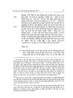
7.3.2.1 Mapping Hydro Network and Urban Areas of Tomsk City
Tomsk City is the capital of the Tomsk region situated in the southeastern part of
Western Siberia. The residential and industrial areas of the city, together with natural
landscape components such as the Tom River and surrounding forestry, form a typical
anthropogenic ecosystem. Thematic mapping was implemented with the purpose of
updating topographical information on urban areas and the hydro network as well
as assessing the ecological condition of water bodies. In the research, the imagery
acquired in July 2000 by a domestic RESURS-O1 satellite (sensor MSU-E, resolu-
tion 30 × 45 m, three spectral bands) was used, allowing the thematic map of
1:50,000 scale to be produced.
Georeferencing of the initial imagery was carried out by means of the “Land-
Mapper” imagery preliminary processing subsystem, making use of an obsolete
vector map (1994) of the Tomsk area hydro network. On the base of the 30 ground
control points clearly distinguished both in the map and in initial imagery, a trian-
gulation network was designed linking map and imagery coordinate systems to each
other. The triangulation network was used for performing imagery linear rectifica-
then the resultant georeferenced imagery was assigned the Gauss-Kruger projection.
Imagery rectification was followed by the thematic processing stage. First, the set
of training samples was formed, relying upon the reference data acquired from the
site visit information as well as from topographic and landscape maps of the Tomsk
area.
Imagery interpretation was performed by means of the ACP, which computed a
few different scale textural sets (with various running window sizes) for every
spectral band of the initial imagery and selected the most informative textural sets
in each scale by the Jeffries–Matusita separability criterion.
The generated textural component of the EFS comprising informative textural
feature sets was classified by the ACP in iterative manner, and the resultant posterior
probability maps were then used for classifying spectral components of imagery
© 2006 by Taylor & Francis Group, LLC
Figure 7.2.
tion, allowing imagery local geometric errors to be compensated (Figure 7.3), and
Advanced Remote Sensing Techniques for Ecosystem Data Collection 117
FIGURE 7.3 Forming a triangulation network linking Tomsk imagery and map with use of ground control points.
© 2006 by Taylor & Francis Group, LLC
118 GIS for Sustainable Development
involving three initial spectral features. The iterative classification details, such as
number of textural or spectral features used, type of PDF estimate chosen by the
ACP in Bayesian rule, as well as thematic map overall classification accuracy
acquired at each iteration, are given in Table 7.1.
produced by the ACP implemented in the “LandMapper” thematic processing sub-
system. In Figure 7.4a and 7.4b the initial multispectral imagery of the Tomsk City
area as well as the obsolete topographic map of the area (1994) superimposed by
updated thematic data are shown. The highlighted thematic layers (Figure 7.4b)
correspond to water bodies and urban constructions (scale 1:50,000). Comparative
GIS analysis of the obsolete map and the updated thematic layers revealed that
boundaries of the urban areas and water objects have changed considerably in the
course of time. A good example of hydro network change detection is given in Figure
7.4c, 7.4d, and 7.4e, depicting the Um river bed area. In addition to change detection
outcomes, the resultant thematic map showed clearly the contaminated conditions
of the Tom River in the northern part of Tomsk City caused by power station.
Together with on-ground measurements data, this map is a valuable information
source for making a decision on ecological conditions improvement.
7.3.2.2 Landscape-Ecological Research of Pervomayskoe Oil Field
Pervomayskoe oil field is situated 180 km southwest from Strezhevoy City and
belongs to the Vasyugan oil-producing area of the Tomsk region. The “LandMapper”
system was applied for landscape-ecological mapping of the oil field with use of
the multispectral imagery acquired in July 1998 by a RESURS-O1 satellite (sensor
MSU-E, resolution 30 × 45 m, three spectral bands). The purpose of landscape-
ecological mapping was to reveal various environmental changes caused by petro-
leum production in the field area.
The preliminary processing stage involved imagery georeferencing and its visual
properties enhancement to enable effective visual inspection. To perform thematic
processing, a number of training sets was selected making use of reference data
acquired from photointerpretation results, aerial photographs (1997 and 2001), and
topographic maps of Pervomayskoe oil field describing its geomorphological struc-
ture and degree of anthropogenic influence. The training sets cover all general
landscape types and consist of anthropogenic objects (roads system, well clusters,
and settlements), old deforested areas and quarry, and natural objects (lakes, swamp,
TABLE 7.1
Tomsk City Imagery Classification Details
Iteration
Window
Size
Features
Selected
PDF Estimate Adopted
in Bayesian Rule
Accuracy,
%
17 × 75 Parzen 85.3
25 × 55 Parzen 92.4
3—3 Gaussian 94.5
© 2006 by Taylor & Francis Group, LLC
Figure 7.4 illustrates some thematic mapping results for the Tomsk City area
Advanced Remote Sensing Techniques for Ecosystem Data Collection 119
FIGURE 7.4 (a) Initial Tomsk City area imagery; (b) topographic map superimposed by refined h
ydro network and urban
area layers; (c) enlarged fragment of Um river bed imagery; (d) obsolete Um river bed map; (e) updated Um river bed map.
© 2006 by Taylor & Francis Group, LLC
120 GIS for Sustainable Development
and forest). The class representing forest area was split up into four subclasses: pine
sphagnous forest, mixed cedar sphagnous forest, coniferous sphagnous forest, and
mixed mossy forest. The class representing swamp was set to subclasses representing
upper sphagnous swamps and marsh areas.
The imagery interpretation stage was implemented by means of the ACP. First,
the informative EFS was generated in the manner described in Section 7.2.2. Feature
selection was performed among textural feature sets generated with running windows
of 11 × 11, 7 × 7, and 5 × 5 pixels size. Then classification was conducted involving
four iterations. Table 7.2 gives the information on classification details in a similar
way to the example described in Section 7.3.2.1. Overall classification accuracy
reached with use of the ACP is about 90% which is almost 15% higher than accuracy
given by the traditional maximum likelihood classification (MLC) technique.
Figure 7.5a shows the fragment of initial imagery of Pervomayskoe oil field,
and Figure 7.5b and 7.5c illustrate the resultant landscape-ecological thematic map
fragments produced with use of the MLC technique and the ACP, respectively. The
comparison of the two classification fragments demonstrates the advantage of
TABLE 7.2
Pervomayskoe Oil Field Imagery Classification Details
Iteration
Window
Size
Features
Selected
PDF Estimate Adopted
in Bayesian Rule
Accuracy,
%
1 11 × 11 7 Gaussian 77.2
27 × 74 Parzen 79.1
35 × 55 Parzen 84.3
4—3 Gaussian 89.5
FIGURE 7.5 (a) Initial imagery of Pervomayskoe oil field; (b) classification using maximum
likelihood technique; (c) classification using the ACP.
© 2006 by Taylor & Francis Group, LLC
employing the ACP for RS-based thematic mapping. As it can be seen from Figure
Advanced Remote Sensing Techniques for Ecosystem Data Collection 121
quite fuzzy boundaries. This effect is due to strong similarity and, as a result, mixing
of some landscape cover types in the spectral feature space of the initial multispectral
imagery (marsh areas and upper swamps; coniferous sphagnous forest, mixed mossy
any noise, and all classes have clear boundaries thanks to incorporation of textural
information within the EFS and using an adaptive decision rule in the ACP.
The acquired raster thematic map produced with the ACP was converted into
vector features, and the feature layers corresponding to different landscape types
were designed. After assigning appropriate attribute information to the mapped
features, the resultant vector landscape-ecological map was applied, together with
vector GIS analysis tools, for computing areas of marshes that appeared close to
industrial objects and for defining the areas of forest devastation. The quantitative
estimations obtained in the GIS analysis allowed the overall anthropogenic load
within the oil field to be assessed.
The designed landscape-ecological map is an essential means for both qualitative
and quantitative statistical analysis of anthropogenic ecosystem structures of the
Pervomayskoe oil field, which is of great importance for supporting management
decision-making on the oil field environment enhancement and ecological situation
forecasting.
7.4 CONCLUSION
The chapter has introduced a methodology of RS-based thematic mapping, based
on an advanced approach to image classification. The approach makes use of image
extended feature space and an adaptive decision rule selecting an optimal (in terms
of accuracy and performance) classification algorithm during the interpretation pro-
cess and allows the quality of the data extracted from a RS image to be improved.
The proposed methodology has been implemented on the base of original image
processing and the “LandMapper” interpretation system functioning in the frame-
work of a vector GIS. Two sample applications have demonstrated the efficiency of
using the “LandMapper” system while solving problems of collecting data on two
anthropogenic ecosystems (Tomsk City and Pervomayskoe oil field) with images
acquired from a domestic RESURS-O1 satellite. The average accuracy of the the-
matic maps produced in the applications with use of “LandMapper” adaptive clas-
sification procedure is about 90%, which is almost 15% higher than that reached by
traditional MLC technique with the same training sets. Along with the accuracy
improvement, the adaptive classification procedure is more time consuming than
traditional MLC technique, due to involving new textural components in the image
feature space and an iterative manner of classification. However in practice, the
computational efficiency factor, as a rule, is considered as less important than
classification accuracy and thus can often be sacrificed to obtain more accurate
thematic maps.
In conclusion, it should be noted that later investigations of the work considered
in the chapter will focus on research on applicability limits of the adaptive classifi-
cation procedure for solving issues of anthropogenic ecosystems data collection and
© 2006 by Taylor & Francis Group, LLC
7.5b, the map produced with MLC is heavily noised, and the mapped classes have
forest, and deforested areas). By contrast, the map in Figure 7.5c does not contain
122 GIS for Sustainable Development
thematic mapping with use of space imagery from SPOT, LANDSAT, and QUICK-
BIRD satellites.
ACKNOWLEDGMENTS
The authors would like to thank Novosibirsk Regional Center of Data Acquisition
and Processing for providing medium-resolution multispectral RESURS-O1 imagery
of the Tomsk region. The work described in the publication has been carried out
with financial support of the Russian Foundation of Basic Research (grant number
03-07-90124).
REFERENCES
1. Vinogradov, B., Foundations of Landscape Ecology, Geos, Moscow, 1998, 418 (in
Russian).
2. Markov, N. and Napryushkin, A., Use of remote sensing data at thematic mapping
in GIS, in Procceedings of the 3rd AGILE Conference on Geographic Information
Science, AGILE, Helsinki, 2000, 51.
3. Vinogradov, B., Aerospace monitoring of ecosystems, Science, Moscow, 1984, 320
(in Russian).
4.
5. Richards, J. and Xiuping, J., Remote Sensing Digital Image Analysis: An Introduction,
Springer, Berlin, 1999, 400.
6. Star, J. and Estes, J., Geographic Information Systems: An Introduction, Prentice-
Hall, Englewood Cliffs, N.J., 1990.
7. Markov, N. and Napryushkin, A., Self-organizing GIS for solving problems of ecol-
ogy and landscape studying, in Proceedings of the 4th AGILE conference on Geo-
graphic Science, AGILE, Brno, 2001, 462.
8. Moik, T., Digital Processing of Remotely Sensed Images, NASA, Washington, D.C.,
1980.
9. Duda, R. and Hart, P., Pattern Classification and Scene Analysis, Wiley, New York,
1973.
10. Lapko, A. and Chenzov, S., Nonparametric systems for information processing,
Science, Moscow, 2000, 350.
11. Markov, N. et al., Adaptive procedure for RS images classification with extended
feature space, in Proceedings of the 9th International SPIE Symposium on Remote
Sensing, Vol.4885, SPIE, Bellingham, 2002, 489.
12. Haralick, R. and Joo, H., A Context Classifier, in IEEE Trans. Geoscience Remote
Sensing, N24, 1986, 997.
© 2006 by Taylor & Francis Group, LLC
NASA’s RS tutorial, The Concept of Remote Sensing, 2003, />Intro/Part2_1.html.
123
8
Spatiotemporal Data
Modeling for “4D”
Databases
Alexander Zipf
CONTENTS
8.1 Introduction 123
8.2 Spatiotemporal Data Modeling 124
8.3 Topological Modeling of Three-Dimensional Geo-Objects 124
8.4 Modeling of Thematic Data: The Example of the History of a City 126
8.5 An Object-Oriented Model for Temporal Data 128
8.5.1 Temporal Structure 129
8.5.2 Temporal Representation 130
8.5.3 Temporal Order 130
8.5.4 Temporal History Type 131
8.6 Putting the Components Together 131
8.7 Integrating Geometry, Thematic and Temporal Model 132
8.8 Object- versus Attribute-Time-Stamping 134
8.9 Dynamical Extensions of Spatial Class Hierarchies with “Aspects” 135
8.10 Conclusions 138
Acknowledgments 140
References 140
8.1 INTRODUCTION
Conventional GIS are usually quite static, as they do not cover dynamic aspects of
geo-objects in their data model. The information on the modeled domain is usually
separated into models of geometric space (2D/3D) and thematic aspects (attributes).
But if someone wants to develop a system that is capable of modeling objects of
the environment including their history, presence, and future, most available systems
lack expressive power. It has been demanded that a temporal GIS (TGIS) needs to
provide functionality for spatiotemporal data storage, data handling, and analysis as
well as visualization. These functions are usually more complex than in conventional
GIS and are still an area of active research.
© 2006 by Taylor & Francis Group, LLC
124 GIS for Sustainable Development
Within the Deep Map/GIS project a flexible and extensive temporal object-
oriented model had been developed [1–3]. The aim was to allow the management
of 3D geo-objects of urban areas over historic epochs and act as a basis for the data
management components of temporal 3D-GIS (“3D-TGIS” or more colloquial “4D-
GIS”) to be developed in the future. Since the temporal part of this model is a self-
consistent OO-model for temporal structures, it can also be used with 2D geodata.
The proposed framework is a contribution toward the development of a temporal
3D-GIS by offering guidelines on how to model the time in a sophisticated way. It
also shows how to integrate these temporal aspects of geo-objects along with their
3D spatial (topological) and thematic aspects. Working prototypes have been realized
that implement these models in an object-oriented and an object-relational database
management system (DBMS), showing the applicability of the proposed concepts.
The model has been demonstrated within the domain of 3D historic city models for
an urban information system.
8.2 SPATIOTEMPORAL DATA MODELING
A geo-object or feature in general consists of the aspects theme, geometry, topology,
and time [4,5]. Still, today’s GIS don’t handle all aspects equally well. The temporal
dimension is an important aspect of most real-world phenomena. Nevertheless,
databases or GIS delivered only a snapshot of the real world. Therefore there was
a need for new data models that allow the handling of temporal data [6,7]. In recent
years, a range of temporal models was also developed in the field of object-oriented
databases [8–10], presenting possibilities for an object-oriented integration of tem-
poral models into 2D-GIS [11–14].
To represent the basic elements of the temporal framework, some important
concepts are defined briefly. The period of the physical process used to measure
time is called “chronon,” while the duration of the period is described as a “granu-
larity.” A temporal framework should provide means for representing arbitrary cal-
endars. Further aspects of time are explained in more detail by Krüger [15].
8.3 TOPOLOGICAL MODELING OF THREE-DIMENSIONAL
GEO-OBJECTS
The development of the data model for 3D geometry is largely influenced by the
model of Molenaar. It combines the geometry and topology of 3D geodata and
allows retrieval of multiple topological properties directly from the model.
The basic concepts include the primitives node (point), arc (line), and face (area).
Thematic attribute data are attached using feature identifiers. Molenaar extended
earlier models by the new primitives edge and body to model the third dimension
The topology of the 3D primitives has been modeled through several 1:n rela-
tionships between the five primitives:
•For every arc there exists exactly one start- and endpoint (node).
•A node can belong to several arcs.
© 2006 by Taylor & Francis Group, LLC
(Figure 8.1, [16]).
Spatiotemporal Data Modeling for “4D” Databases 125
•A face can only margin two bodies, while one body can have several faces.
• There are links between arcs and nodes to the face they belong to or the
body they are part of.
•Face and body both consist of several nodes or arcs.
A unified modeling language (UML) class diagram that models the geometry
model of the framework is depicted in Figure 8.2.
The data model introduced so far describes the topology of up to three-dimen-
sional objects. The actual geometrical data is integrated by relating multiple versions
FIGURE 8.1 Topological relationships between the 3D primitives (after [16]).
FIGURE 8.2 Class diagram for 3D topological geometry information.
node arc edge
face
body
Start
End
forward
backwards
delimits
rightleft
is in
is in
is on
is on
1: n
cell0
(geometry)
cell0_view
(geometry)
cell1_view
(geometry)
cell2_view
(geometry)
combCell
(geometry)
cell1
(geometry)
cell2
(geometry)
cell3
(geometry)
1 *
0 *
0 *
1 *
0 1
0 1
0 *
1 *
1 *
1 *
1 *
1 *
0 *
0 *
0 *
1 1
1 1
0 *
1 *
© 2006 by Taylor & Francis Group, LLC
126 GIS for Sustainable Development
of geometry to the primitives. In the case of nodes these are the actual coordinates;
for an arc these are the coordinates of the vertices (points in between nodes,
representing geometry).
The body primitive does not need further geometric information, because it is
described by the constituting faces. The classes for the geometry were realized
similarly according to the 3D model using the primitives Point, Face, and Body.
They shall be called 0-Cell (cell0), 1-Cell (cell1), 2-Cell (cell2), and 3-Cell (cell3)
according to their dimensionality (see Figure 8.3).
Within the spatiotemporal model, only the primitives 2-Cell or 3-Cell have been
used.
The realization of the relationships between the spatial and temporal parts of
the model has been achieved using coupling classes. This class is called combCell.
Both primitives 2-Cell and 3-Cell inherit properties from that. Modeling these
relationships using coupling classes offers the following benefits: first, redundancy
is minimized, and secondly, the geometrical components can be coupled in a more
flexible way with temporal aspects, as the individual parts of the model can be
exchanged or altered freely. If another class also inherits from combCell, it can
replace the spatial model we used with a different one easily.
8.4 MODELING OF THEMATIC DATA: THE EXAMPLE
OF THE HISTORY OF A CITY
The structures describing the thematic aspects of the features (geo-objects) are also
realized using an object-oriented model. The thematic model cannot be generic but
is oriented toward the application domain. In the case of the Deep Map project, this
was a city information system, where individual buildings with their visible parts
(from outside) and other man-made structures within a city are modeled. Other
geographic domains can also be applied by extending or exchanging the thematic
model.
The most important three-dimensional real-world objects are in our case build-
ings, monuments, bridges, fountains, gates, and roads. Parts of such 3D objects may
belong to the classes body (of a building), stair, tower, roof, wall, or yard. But as it
is likely that more complex 3D objects need to be represented, it seems sensible to
This is realized through the relationships between the class threeD_Obj and
part_threeD_Obj. This allows assembling several parts of a 3D object together within
the thematic model. An example is the definition of an object “southern wing” (e.g.,
FIGURE 8.3 Graphical representation of the primitives 0-Cell, 1-Cell, 2-Cell and 3-Cell.
AA
A
A
B
B
B
C
C
D
D
E
F
G
H
© 2006 by Taylor & Francis Group, LLC
be able to aggregate such objects to a more complicated semantic unit (Figure 8.4).
Spatiotemporal Data Modeling for “4D” Databases 127
of the building “Villa Bosch”) by combining the objects “body” (of south wing),
roof (of south wing), and further parts of the south wing. These objects can also be
used in queries to the database.
A further requirement on the data model was that it should allow queries to
details of a facade of a building, like “Which parts belong to the northern facade of
an object?” or “What are the properties of the window next to the entrance door?”
In order to allow this, the main elements of a facade are modeled explicitly. This
includes classes for balcony, door, molding, painting, window, or ornament, which
all can be attached to a part of the facade. So just as there are 3D objects and their
parts, there are surfaces that can be separated in several parts of a surface that can
be addressed independently.
A part of the thematic model for buildings is depicted in Figure 8.4: The classes
threeD_Obj, part_threeD_Obj, surface, and part_surface are used for realizing the
corresponding main aspects of a threeD_Object, part_threeD_Object, surface
(facade), and part_surface. Using these classes the properties of the corresponding
subtypes are modeled.
As already explained, generalization allows not only minimizing redundancy
when defining subtypes, but also results in a well extensible structure. The integration
FIGURE 8.4 Class diagram for thematic information.
wall
(thematic)
tower
(thematic)
yard
(thematic)
monument
(thematic)
tower
(thematic)
threeD_Obj
(thematic)
body
(thematic)
surface
(thematic)
part_surface
(thematic)
part_threeD_Obj
(thematic)
yard
(thematic)
well
(thematic)
balcony
(thematic)
door
(thematic)
molding
(thematic)
painting
(thematic)
window
(thematic)
ornament
(thematic)
gate
(thematic)
bridge
(thematic)
building
(thematic)
road
(thematic)
well
(thematic)
roof
(thematic)
staircase
(thematic)
summary
(thematic)
themGeo
(thematic)
0 *
parts
belongs_t
o
0 *
belong
s_to
1 1
belongs_to
parts
0 *
0 *
parts
1 1
1 1
parts
© 2006 by Taylor & Francis Group, LLC
128 GIS for Sustainable Development
of new subtypes can be achieved by defining inheritance relationships to the corre-
sponding main class (Figure 8.5).
In order to model the relationships between 3D objects and their parts, base
bodies, and their facades as well as between facades and the objects belonging to a
facade, bidirectional 1:n relationships are being used.
In the realized prototype, only parts of 3D objects, facades, and parts of facades
are linked to spatiotemporal data structures. This is very application specific. In
order to change this relation easily, these kinds of relations are modeled using an
extra class, which is called “themGeo.” This improves flexibility, for example, to
exchange the geometry model with a different description (e.g., GML, [17]).
Figure 8.5 shows the realized relationships between thematic and geometric data
within the “4D” model explained. The geometric description for the thematic classes
part_threeD_Obj and part_surface is realized using the class cell3 (body), while for
the thematic class surface the class cell2 (face) is used. When there is only 3D
information available for a part of a 3D object or for parts of a facade, this can be
expressed by the modeler through the usage of the hierarchical structure of the spatial
model by using 3-Cells that only use a 2-Cell (face). The geometry of a 3D object
is represented through the geometries (3-cells) of the parts of the 3D object.
8.5 AN OBJECT-ORIENTED MODEL FOR TEMPORAL DATA
The object-oriented paradigm has also been used for the modeling of a general time
framework. The range of possible different applications puts quite complex requirements
FIGURE 8.5 Class diagram for the relationship between thematic aspects and geometry.
threeD_Obj
(thematic)
part_threeD_Obj
(thematic)
body
(thematic)
surface
(thematic)
part_surface
(thematic)
cell3
(geometry)
cell2
(geometry)
1 1
1 1
1 1
belongs_to
belongs_to
belongs_to
parts
parts
parts
0 *
0 *
0 *
© 2006 by Taylor & Francis Group, LLC
Spatiotemporal Data Modeling for “4D” Databases 129
on temporal support. First it is necessary to identify the dimensions limiting the
modeling space of a general temporal model. Further, the components and properties
have to be determined in order to be able to define an adaptable structure that fulfils
the various requirements. From these a framework for building temporal models was
developed using the identified components. It supports design alternatives by the
provision of a range of classes and accompanying properties. These temporal classes
can be integrated with the models for the geometry and for the thematic aspects
already introduced to a composite model for temporal 3D geo-objects.
Regarding time, one can distinguish the following general aspects:
• Temporal Structure defines a structure using temporal primitives, domains,
and structures concerning temporal determination (certain or uncertain
representations).
• Temporal Order describes the possible types of orders of temporal struc-
tures.
• Temporal History describes the semantic meaning of the different states
of the object.
• Temporal Representation describes how to represent calendars and gran-
ularities.
8.5.1 T
EMPORAL
S
TRUCTURE
The temporal structure defines, through its parts, a base for the temporal model
1. Temporal primitives are represented either as absolutes (anchored, “date”
[e.g., 5-9-1999] or relative (unanchored, “period of time” [e.g., 30 days]).
2. Temporal domain: It is possible to distinguish discrete and continuous
domains. In the field of temporal databases a discrete time domain is
usually used.
3. Temporal determination: In the deterministic case complete and exact
knowledge is available for temporal primitives. On the other hand, these
are not determined exactly in indeterministic cases [18] (e.g., fuzzy tem-
poral borders).
The topmost level of the temporal structure-model consists of absolute
(anchored) and relative (unanchored) temporal primitives. The next hierarchical level
supplements the structure with domains, being either discrete or continuous. The
deterministic and nondeterministic primitives form the last component. A temporal
structure consists of a combination of all of the represented temporal primitives.
Through the combination of the different properties offered within the three levels
of the hierarchy to model temporal aspects of the world, it is possible to distinguish
eleven temporal types as “temporal primitives” (the twelfth one is only a theoretical
combination, because “nondeterministic continuous time points [instants]” are not
possible because of contradicting properties). The temporal primitives represent the
© 2006 by Taylor & Francis Group, LLC
(Figure 8.6). This temporal “structure” can have the following properties [18]:
130 GIS for Sustainable Development
fundament for representing temporal data. Further, it is necessary to distinguish
between the logical and physical representation of a time value. If the time value is
described by means of a calendar, it is a logical representation.
One can define a broad range of operations for the suggested data types. Langran
[12] defines a range of categories for the operations according to their purpose and
the types of arguments and results, as stated below. Krüger [15] explains the realized
operators within our model in more detail:
• Build-in-functions allow the type conversion between temporal data types
as well as combination or comparison functions.
• Arithmetical Operators offer the corresponding adaptation of the basic
arithmetic functions.
• Comparison operations give back a Boolean value (they are used for
checking the correctness of selection criteria).
• Aggregation functions: The well-known aggregation functions from SQL
like COUNT, SUM, AVG, MAX, and MIN can also be adapted for
temporal data types.
8.5.2 T
EMPORAL
R
EPRESENTATION
The proposed temporal primitive data types offer a basis for the representation of
temporal data. For a temporal value that is represented by an instance of such a
temporal data type, it is necessary to distinguish between logical and physical
representations of this value. If the value is represented using a calendar, it is a
logical representation. While supporting multiple logical calendars, the value of
temporal data types is stored independent from a calendar within the implemented
framework. This means that the point of time is stored as a chronon of the base
watch. But within the framework, there are classes for different calendars available,
which define the logical representation through the definition of usable granularities,
referencing the chronons of the base watch. They also offer functions for converting
between the physical and logical representations of the temporal objects.
8.5.3 T
EMPORAL
O
RDER
The course of the time can be classified as linear, sub linear or branching. In both
cases time is generally regarded as running linearly from past to future. They only
differ regarding the handling of subordinate spatial basic types (primitives). In the
linear case overlapping borders of temporal primitives are forbidden, while they are
possible in the sub-linear case. A sub-linear order can also be used for managing
indeterministic temporal phenomena. This can for example be used for the temporal
description of the changes of an object that are only known roughly.
The concept of branching order time allows time to be to regarded as linear only
up to a certain point of time. A typical example would be town planning, where
different planning alternatives can be managed in different branches of the resulting
temporal tree. In each of the branches of that tree a partial order of time is defined.
© 2006 by Taylor & Francis Group, LLC