Introduction to GPS The Global Positioning System - Part 11 ppt
Bạn đang xem bản rút gọn của tài liệu. Xem và tải ngay bản đầy đủ của tài liệu tại đây (118.81 KB, 5 trang )
11
Other Satellite Navigation Systems
11.1 GLONASS satellite system
GLONASS is an all-weather global navigation satellite system developed by
Russia. The GLONASS satellite system has much in common with the GPS
system. The nominal constellation of the GLONASS system consists of 21
operational satellites plus three spares at a nominal altitude of 19,100 km.
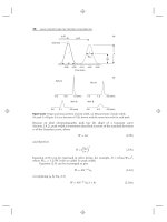
Eight GLONASS satellites are arranged in each of three orbital planes (see
Figure 11.1). GLONASS orbits are approximately circular, with an orbital
period of 11 hours and 15 minutes and an inclination of 64.8° [1, 2].
Similar to GPS, each GLONASS satellite transmits a signal that has a
number of components: two L-band carriers, C/A-code on L1, P-code on
both L1 and L2, and a navigation message. However, unlike GPS, each
GLONASS satellite transmits its own carrier frequencies in the bands
1,6021,615.5 MHz for L1 and 1,2461,256.5 MHz for L2, depending on
the channel number. These two bands are on their way to being shifted to
1,598.06251,604.25 MHz and 1,242.93751,247.75 MHz, respectively, to
avoid interference with radio astronomers and operators of low-Earth-
orbiting satellites. With this shift, each pair of GLONASS satellites will be
assigned the same L1 and L2 frequencies. The satellite pairs, however, will
155
be placed on the opposite sides of the Earth (antipodal), which means that
a user cannot see them simultaneously. GLONASS codes are the same for
all the satellites. As such, GLONASS receivers use the frequency channel
rather than the code to distinguish the satellites. The chipping rates for the
P-code and the C/A-code are 5.11 and 0.511 Mbps, respectively. The
GLONASS navigation message is a 50-bps data stream, which provides,
among other things, the satellite ephemeris and the channel allocation [2].
The signal of GLONASS system is not affected by either SA or antispoofing.
The GLONASS system completed 24 working satellites in January 1996.
Unfortunately, however, the number of GLONASS satellites had dropped
to only seven satellites by May 2001 [3]. It is expected that a new genera-m
tion GLONASS satellites, GLONASS-M, will be launched in the near
future. GLONASS-M has a lifetime of 5 years, improved onboard atomic
clocks, and the facility to transmit the C/A code on both L1 and L2 carrier
frequencies [4].
GPS and GLONASS systems may be integrated to improve geometry
and positioning accuracy, particularly under poor satellite visibility, such
as in urban areas. There are, however, two problems with GPS/GLONASS
integration. The first one is that both GPS and GLONASS systems use dif-
ferent coordinate frames to express the position of their satellites. GPS uses
the WGS 84 system, while GLONASS uses the Earth Parameter System
1990 (PZ-90) system. The two systems differ by as much as 20m on the
Earths surface. The transformation parameters between the two systems
may be obtained by simultaneously observing reference points in both
systems. Various research groups have developed various sets of trans-
formation parameters [2, 5]. However, accurate determination of the
156 Introduction to GPS
Figure 11.1 GLONASS system. (Satellite image courtesy of Magellan
Corporation.)
transformation parameters is still unavailable. The second problem with
the GPS/GLONASS integration is that both systems use different reference
times. The offset between the two time systems changes slowly and reaches
several tens of microseconds. One way of determining the time offset is by
treating it as an additional variable in the receiver solution.
11.2 Chinese regional satellite navigation system
(Beidou system)
China has recently launched two domestically built navigation satellites,
which form the first generation of a satellite-based navigation system
[68]. It is an all-weather regional navigation system, which is known as
the Beidou Navigation System. The satellites are placed in geostationary
orbits at an altitude of approximately 36,000 km above the Earths surface.
The primary use of the system is in land and marine transportation. China
is also planning to build its second-generation satellite positioning and
navigation system, which will have more satellites and more coverage area.
11.3 Regional augmentations
The current satellite-based global navigation systems, GPS and GLONASS,
do not meet all of the civil aviation requirements. To overcome these limi-
tations, regional augmentation systems are currently being developed. A
regional augmentation system typically combines one or more satellite
constellations such as GPS and GLONASS, geostationary satellites
equipped with navigation transponders and a number of ground reference
stations [9]. Merging the various interoperable regional systems leads to a
Global Navigation Satellite System (commonly known as GNSS-1) that
meets the civil aviation requirements. In fact, the International Civil Avia-
tion Organization (ICAO) has endorsed the GNSS as the core system for
international aviation use [9].
Various regional augmentation systems are currently being developed
as part of the worldwide GNSS. The United States is developing a GPS-
based regional system called the Wide Area Augmentation System
(WAAS), which covers North America with the possibility of extending to
include South America. Europe is developing a similar regional system
called European Geostationary Navigation Overlay System (EGNOS),
Other Satellite Navigation Systems 157
which is based on both GPS and GLONASS. It covers Europe and North
Africa with the possibility of extending to include all of Africa and the Mid-
dle East. A third regional GPS-based system, called Multi-function Trans-
port Satellite (MTSAT), is being developed in Japan, and covers parts of
Asia and the Pacific region. Australia is also in the process of developing its
own regional system. The regional systems are expected to merge and be
interoperable [9].
11.4 Future European global satellite navigation system
(Galileo system)
Galileo is a satellite-based global-navigation system proposed by Europe.
Galileo is a civil-controlled satellite system to be delivered through a
public-private partnership [10]. Three different constellation types were
investigated to ensure the optimum selection of the Galileo architecture,
namely low Earth orbits (LEO), medium Earth orbits (MEO), and inclined
geosynchronous orbits (IGSO). Combinations of various constellation
types were also studied. Following this study, the Galileo decision mak-
ers adopted a constellation of 30 MEO satellites. The satellites will be
evenly distributed over three orbital planes at an altitude of about 23,000
km. This selection ensures that more uniform performance is obtained
for all regions (i.e., independent of the regions latitude). The signal char-
acteristics of the Galileo system were to be determined sometime in
2001 [10].
Galileo will be compatible at the user level with the existing GPS and
GLONASS systems. However, unlike GPS and GLONASS, Galileo will pro-
vide two levels of services: a basic, free-of-direct-charge service and a
chargeable service that offers additional features. Some security measures,
such as withholding of the service, have been studied to ensure that the sys-
tem is properly used. A European political body, independent of Galileo
management, will have the authority to take the proper measures in the
event of a crisis.
The Galileo development plan will be divided into three different
phases.
1. The definition phase was concluded at the end of 2000.
2. The development and validation phase began in 2001 and has been
extended for a period of 4 years. This phase comprises a more
158 Introduction to GPS
detailed definition of the Galileo system (e.g., frequency alloca-
tion). As well, it includes the construction of the various segments
of the system (space, ground, and receiver). Some prototype satel-
lites will be launched in 2004, along with the establishment of a
minimal ground infrastructure, to validate the system.
3. The constellation deployment phase is scheduled to begin in 2006
and extend until 2007. With the experience gained during the
system validation phase, operational satellites will be gradually
launched during this phase. In addition, ground infrastructure will
be completed.The target date for the gradual introduction of Gali-
leo operational service is 2008 or shortly thereafter. At that time,
EGNOS service will be provided in parallel until it is phased out in
2015 [10].
References
[1] Kleusberg, A., Comparing GPS and GLONASS, GPS World,Vol.1,
No. 6, November/December 1990, pp. 5254.
[2] Langley, R. B., GLONASS: Review and Update, GPS World,Vol.8,
No. 7, July 1997, pp. 4651.
[3] Navtech Seminars and GPS Supply, GPS/GNSS newsletter, May 17, 2001.
[4] Johnson, N. L., GLONASS Spacecraft, GPS World, Vol. 5, No. 11,
November 1994, pp. 5158.
[5] Bazlof, Y. A., et al., GLONASS to GPS: A New Coordinate
Transformation, GPS World, Vol. 10, No. 1, January 1999, pp. 5458.
[6] CANSPACE, China Puts Second Navigation Positioning Satellite into
Orbit, Canadian Space Geodesy Forum, December 21, 2000.
[7] CANSPACE, Chinese Launch Navigation Satellite, Canadian Space
Geodesy Forum, October 31, 2000.
[8] CANSPACE, Chinese Satellite Navigation System Update, Canadian
Space Geodesy Forum, January 9, 2001.
[9] Kayton, M., and W. R. Fried, Avionics Navigation Systems, 2nd ed., New
York: Wiley, 1997.
[10] Commission of the European Communities, Commission
Communication to the European Parliament and the Council on
GALILEO, Brussels, Belgium, November 22, 2000.
Other Satellite Navigation Systems 159