amazing world geography a book of answers for kids
Bạn đang xem bản rút gọn của tài liệu. Xem và tải ngay bản đầy đủ của tài liệu tại đây (8.33 MB, 180 trang )
THE NEW YORK
PUBLIC LIBRARY
AMAZING
WORLD GEOGRAPHY
A Book of Answers for Kids
Andrea Sutcliffe
A Stonesong Press Book
John Wiley & Sons, Inc.
THE NEW YORK
PUBLIC LIBRARY
AMAZING
WORLD GEOGRAPHY
A Book of Answers for Kids
Andrea Sutcliffe
A Stonesong Press Book
John Wiley & Sons, Inc.
This book is printed on acid-free paper.
Copyright ©2002 by The New York Public Library and The Stonesong Press, Inc. All
rights reserved
Published by John Wiley & Sons, Inc., Hoboken, New Jersey
Published simultaneously in Canada
All maps prepared by Netmaps, S.A.
Photo p. 66, Charles & Josette Lenars, CORBIS; p. 78, General Research Division,
Humanities and Social Sciences Library, The New York Public Library, Astor, Lenox and
Tilden Foundations; p. 92, Photography Collection, Humanities and Social Sciences
Library, The New York Public Library, Astor, Lenox and Tilden Foundations; p. 102, Asian
and Middle Eastern Division, Humanities and Social Sciences Library, The New York
Public Library, Astor, Lenox and Tilden Foundations; p. 114, General Research Division,
Humanities and Social Sciences Library, The New York Public Library, Astor, Lenox and
Tilden Foundations
The name “The New York Public Library” and the representation of the lion appearing in
this work are trademarks and the property of The New York Public Library, Astor, Lenox,
and Tilden Foundations.
No part of this publication may be reproduced, stored in a retrieval system, or trans-
mitted in any form or by any means, electronic, mechanical, photocopying, recording,
scanning, or otherwise, except as permitted under Section 107 or 108 of the 1976
United States Copyright Act, without either the prior written permission of the Publisher,
or authorization through payment of the appropriate per-copy fee to the Copyright
Clearance Center, 222 Rosewood Drive, Danvers, MA 01923, (978) 750-8400, fax
(978) 750-4470, or on the web at www.copyright.com. Requests to the Publisher for
permission should be addressed to the Permissions Department, John Wiley & Sons,
Inc., 111 River Street, Hoboken, NJ 07030, (201) 748-6011, fax (201) 748-6008, email:
Limit of Liability/Disclaimer of Warranty: While the publisher and author have used their
best efforts in preparing this book, they make no representations or warranties with
respect to the accuracy or completeness of the contents of this book and specifically dis-
claim any implied warranties of merchantability or fitness for a particular purpose. No
warranty may be created or extended by sales representatives or written sales materials.
The advice and strategies contained herein may not be suitable for your situation. You
should consult with a professional where appropriate. Neither the publisher nor author
shall be liable for any loss of profit or any other commercial damages, including but not
limited to special, incidental, consequential, or other damages.
For general information about our other products and services, please contact our
Customer Care Department within the United States at (800) 762-2974, outside the United
States at (317) 572-3993 or fax (317) 572-4002.
Wiley also publishes its books in a variety of electronic formats. Some content that
appears in print may not be available in electronic books.
ISBN 0-471-39296-0
Printed in the United States of America
10987654321
Introduction . . . . . . . . . . . . . . . . . . . . . . . . . . . . . . . . . . . . 1
1T
HE WORLD ASAWHOLE . . . . . . . . . . . . . . . . . . . . . 3
2N
ORTH AND
CENTRAL AMERICA . . . . . . . . . . . . . . . . . 35
3S
OUTH AMERICA . . . . . . . . . . . . . . . . . . . . . . . 57
4E
UROPE . . . . . . . . . . . . . . . . . . . . . . . . . . . . 67
5A
SIA
. . . . . . . . . . . . . . . . . . . . . . . . . . . . . . 83
6A
FRICA . . . . . . . . . . . . . . . . . . . . . . . . . . . . . 107
7O
CEANIA AND ANTARCTICA . . . . . . . . . . . . . . . . 123
World Countries and Territories Listed Alphabetically . . . . . . . . . 134
Glossary . . . . . . . . . . . . . . . . . . . . . . . . . . . . . . . . . . . . . . . 158
Selected Bibliography . . . . . . . . . . . . . . . . . . . . . . . . . . . . . . 161
The New York Public Library’s Recommended Reading List . . . . . . . 163
Internet Resources . . . . . . . . . . . . . . . . . . . . . . . . . . . . . . . . 164
Index . . . . . . . . . . . . . . . . . . . . . . . . . . . . . . . . . . . . . . . . 165
CONTENTS
Why is geography important? For one thing, geography helps us to better
understand the world we live in. It takes us out of our own neighborhoods and
shows us where and how the world’s other people live. Geography shows us
the connections between people and places. Geography also describes how
places on the earth change over time and how humans contribute to those
changes. With this knowledge, geography lets us peer into the earth’s future.
This book begins by giving you a geographic snapshot of the world as a
whole, often using the United States as a point of comparison. It then takes you
on a tour of the earth’s seven continents and 191 countries. You’ll learn about
places and people, landscapes and languages. You’ll learn about the largest
and smallest, the highest and lowest, and the hottest and coldest. You’ll learn
which countries are growing, and which are shrinking, and why. You’ll see
how we depend on other parts of the world for so many of the products we
use in our part of the world.
The questions here are just a start—the earth is way too big and interest-
ing to be covered in one small book. We hope you’ll soon be asking questions
of your own. For answers, and to learn more about geography in general, we
encourage you to visit the New York Public Library or your local library, and
perhaps check out the geography resources listed at the back of this book.
INTRODUCTION
Does the earth have six or seven continents? ◆ What is a
tectonic plate?
◆ Have the continents always looked the
they do today?
◆ Where is zero degrees latitude and zero
degrees longitude?
◆ Why do maps always show the North
Pole at the top?
◆ How old is the earth? ◆ How far is it to
the center of the earth?
◆ Who owns the oceans? ◆ Which
is the largest ocean in the world?
◆ What is the world’s
largest island?
◆ Is the pull of gravity the same all over the
earth?
◆ How much of the earth is covered with water? ◆
How much of all the water on the earth is in the oceans? ◆
Where is most of the earth’s freshwater found? ◆ Where is
the world’s wettest place?
◆ Where do most earthquakes h
Does the earth have six or seven continents?
Traditionally, there are seven continents: North
America, South America, Europe, Asia, Africa, Australia,
and Antarctica. But there are just six distinct land masses
because Europe and Asia lie on top of a single tectonic
plate, called Eurasia.
The dividing line between the continents of Europe
and Asia is usually the Ural Mountains in western Russia.
What is a tectonic plate?
The earth’s crust is not one continuous shell, but
instead is broken up into many pieces, which scientists
call tectonic plates. No one is sure how many plates there
are, but the number is probably between 20 and 40. The
continents rest on top of these plates, and over millions of
years the plates bearing the continents have been moving
relative to one another.
When these plates bump into each other, earthquakes
and volcanoes can occur and mountains may form. When
the plates pull apart from each other, continents may
break apart and oceans may form.
The
World
As a Whole
Chapter 1
4
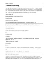
The seven continents are actually six separate land
masses; Europe and Asia share the Eurasian tectonic plate.
T HE W ORLD A SAW HOLE 5
Have the continents always looked the way they do
today?
No, not according to the theory of continental drift.
Scientists believe that early in the earth’s history, there
was just a single landmass, or continent, which they call
Pangaea. About 200 million years ago, Pangaea broke up
and the pieces began to drift.
Today’s continent of Africa was at the center of
Pangaea. South America broke off from southwestern
Africa and drifted west, Antarctica broke away from
Africa’s southern tip and drifted south, and Australia
broke off from Antarctica and headed east. North America
split off from Africa’s northwest coast and shifted west,
and Eurasia broke off the top and moved north.
At one point, India split off from Africa’s east coast
and was an island for a long time, until it moved north
into Asia, pushing against it so hard that the movement
created the Himalayas. If you study the shapes of the con-
tinents on a map, you can see how their general outlines
match up with one another.
The continents are still moving today.
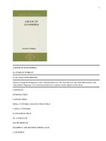
The division of the
supercontinent of
Pangaea began
roughly 200 to 225
million years ago.
The continents as we
know them today
began forming then,
and the tectonic
plates that carry
them continue to
move.
6AMAZING W ORLD G EOGRAPHY
Where is zero degrees latitude and zero degrees
longitude?
It’s a point in the Atlantic Ocean, south of the African
country of Ghana and west of another African country,
Gabon. This is where the prime meridian and the Equator
intersect.
Why do maps always show the North Pole at the
top?
Not for any good reason. It’s just been the way most
map makers through time, most of whom have lived in the
Northern Hemisphere, have shown the world on paper.
Northern Hemisphere: The half of the
earth that lies north of the Equator,
between 0° (the Equator) and 90°
north latitude (the North Pole).
Southern Hemisphere: The half of the
earth that lies south of the Equator,
between 0° (the Equator) and 90°
south latitude (the South Pole).
Equator: The imaginary line of 0° lat-
itude that lies midway between the
North and South poles.
Prime meridian: The imaginary line
denoting 0° longitude that passes
through the Royal Observatory in
Greenwich, England.
Longitude: The distance east or west
of the prime meridian, from 0° to
180° east or west. Lines of longi-
tude run north–south.
Latitude: The distance north or south
of the Equator, from 0° to 90° north
or south. Lines of latitude run
east–west and are parallel to each
other. Together, lines of latitude and
longitude form a grid that lets us
pinpoint exact locations on the
earth’s surface.
North Pole: The northern extremity
of the earth’s axis (the invisible line
about which a body spins or
rotates), and the northern point
from which all meridians of longi-
tude begin. The north polar region
is made up of ice-covered ocean.
South Pole: The southern extremity
of the earth’s axis, and the southern
center from which all meridians of
longitude begin. The south polar
region is made up of land.
Arctic Circle: The parallel of latitude
that is about 66.5° north of the
Equator that surrounds the north
frigid zone.
Antarctic Circle: The parallel of lati-
tude that is about 66.5° south of
the Equator that surrounds the
south frigid zone.
Geographic Terms to Know
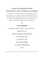
7
Lines of latitude and longitude don’t physically exist; they are
concepts created by geographers and cartographers that
make it easier for humans to describe locations on Earth.
8AMAZING W ORLD G EOGRAPHY
How old is the earth?
Geologists estimate that the earth is about 4.6 billion
years old. One way to tell the age of the earth is to figure
out the age of the oldest rocks. In the very early days of
our planet, molten rock, or magma, spread over the
earth’s surface and eventually cooled, forming the crust.
Much of this rock has been buried or re-formed since that
time, but some very old rocks can still be found.
The oldest known rocks are about 4 billion years old.
These rocks, called tonalite gneiss, were found in 1999
north of Yellowknife in Canada’s Northwest Territories.
Other very old igneous rocks have been found in
Greenland and Australia. Igneous rocks are those that
formed from the hot molten material found deep below
the earth’s surface.
Common geo-
graphic terms are
illustrated above.
Many are derived
from ancient Greek
words. For example,
the word hemisphere
means half a globe;
thus the Northern
Hemisphere refers to
the northern half of
the earth, the
Southern Hemi-
sphere means the
southern half, and
the Eastern and
Western Hemi-
spheres refer to the
eastern and western
halves of the globe.
T HE W ORLD A SAW HOLE 9
How far is it to the center of the earth?
It’s about 3,700 miles (5,957 km).
Who owns the oceans?
Countries don’t actually own the waters that surround
them, but for centuries countries have claimed that certain
distances off their shores belong to them. The usual dis-
tance was about 3 nautical miles. (A nautical mile is
equivalent to about 1.15 land miles, or 1,852 meters.) The
waters off a country’s coastline are important not only
because of fishing rights, but also because of the mineral
and oil resources that may lie beneath the ocean floor.
In 1945, the United States began to claim its entire
continental shelf—about 200 nautical miles off the Atlantic
coast—as its territory. (A continental shelf is the under-
water land that borders a continent.) Soon after, several
South American countries claimed the same distances off
their shores.
The United Nations has decided that all countries
should have uniform limits on sea territories. No law has
been passed yet, but most countries now agree on two
limits: a 12-mile nautical sea zone, in which the country
can enforce laws and exploit natural resources; and a 200-
mile economic exploitation zone, in which the country
can exploit, develop, manage, and conserve all the
resources in the water, on the ocean floor, and in the sub-
soil. That covers everything from fish to oil and gas.
Which is the largest ocean in the world?
The Pacific Ocean is the largest by far. It’s twice the
size of the Atlantic Ocean, covering 64 million square
miles (165.7 million sq km). It’s also the deepest ocean. At
the Mariana Trench, the deepest area of the Pacific, the
seafloor is 36,198 feet (11,033 m)—almost 7 miles—below
the surface.
The Pacific Ocean is so large that all the earth’s conti-
nents could fit within its area with plenty of room left over.
The Pacific Ocean holds almost half the world’s water.
What is the world’s largest island?
Greenland has 840,000 square miles (2,184,000 sq
km), making it the largest island in the world. According
More than one-
third of the
world’s people
live within 60
miles of a coast-
line.
The Indian
Ocean is almost
as large as the
Atlantic Ocean.
10 A MAZING W ORLD G EOGRAPHY
to legend, it was named Greenland by its Norwegian dis-
coverer, Erik the Red, in A.D. 985 because he wanted to
encourage people to settle there. In truth, most of
Greenland lies within the Arctic Circle and is partially
green only for a short time in the summer.
Most of Greenland—nearly 85 percent—is covered
with a huge ice sheet that averages about 5,000 feet (1,524
m) thick. From the island’s northernmost point, the North
Pole is only 500 miles (805 km) away.
A map of the earth
showing the Pacific
Ocean at its center
reveals just how
much of the earth’s
surface the Pacific
covers.
T HE W ORLD A SAW HOLE 11
Is the pull of gravity the same all over the earth?
Not quite. Although gravity is relatively the same
everywhere, there are small variations. These are due to
differences in density in the earth’s mass. Scientists have
recently discovered, with the help of two earth-orbiting
satellites, that the pull of gravity is slightly less off the
coast of India. They think this may be because of tectonic
material left behind after the Indian subcontinent collided
into the Eurasian tectonic plate millions of years ago. If
you weigh 100 pounds in the United States, these scien-
tists think you’d weigh about 1 percent, or about 1 pound,
less in India.
How much of the earth is covered with water?
About 70 percent.
How much of all the water on the earth is in the
oceans?
More than 97 percent of the earth’s water is salty sea
water. All of the earth’s freshwater—water found in ice
caps, lakes, rivers, and as groundwater (which is water
found close to the surface, in wells and aquifers)—
accounts for the remaining 3 percent.
Where is most of the earth’s freshwater found?
Almost 70 percent of the all the freshwater in the
world is frozen in Antarctica’s and Greenland’s ice caps.
The other 30 percent is found in the atmosphere, streams,
lakes, and groundwater.
The Great Lakes, in the United States and Canada,
hold 6 quadrillion gallons of water and make up about
one-fifth of the world’s freshwater supply. Lake Baikal in
Russia holds another one-fifth of the world’s freshwater.
Where is the world’s wettest place?
Lloro, Colombia, in South America receives the high-
est average annual precipitation in the world—an esti-
mated 523.6 inches (1,330 cm) of rain a year, according to
the U.S. National Oceanographic and Atmospheric
Administration.
People in North
America use eight
times as much
freshwater as
people in Africa.
12 A MAZING W ORLD G EOGRAPHY
Where do most earthquakes happen?
Most earthquakes and volcanoes take place along
plate boundaries—places where tectonic plates meet.
One of the most active areas is around the Pacific Plate,
known as the Ring of Fire.
Where did the most deadly earthquake in the world
occur?
A terrible earthquake struck central China in 1557,
killing about 830,000 people. Most died because they
were living in caves made of soft rock, which collapsed
during the quake. In more recent times, a 1976 earth-
quake in Tangshan, China, killed more than 250,000 peo-
ple. It had a magnitude of 8.2.
What was the most powerful earthquake in the
twentieth century?
A 1960 earthquake in southern Chile, along the coast
of South America, had a magnitude of 9.5. The earthquake
caused a tsunami, or huge wave, which destroyed several
fishing villages on Chile’s coastline and then raced across
T
he Ring of Fire is home to more
than half the world’s 1,500 active
volcanoes. Geologists use the term
“active” to mean that a volcano may
erupt again someday. Earthquakes are
also common in the Ring of Fire.
Encircling most of the Pacific
Ocean, the Ring of Fire extends from
New Zealand in the South Pacific,
north to Asia and Japan, across the
northern Pacific to Alaska, and then
south along the west coasts of North,
Central, and South America.
Volcanoes are more likely to occur
in these areas because the edges of
the tectonic plates on which the
Pacific Ocean sits are slowly pushing
under other ocean plates or the
plates of the surrounding continents.
Geologists call this action subduction.
Subduction creates heat that
melts materials inside the earth, cre-
ating magma. The magma weighs
less than the rock that surrounds it,
so eventually it rises and comes out
of the earth in the form of lava—the
hot molten rock that is spewed from
volcanoes.
The Ring of Fire
13
The Ring of Fire surrounds the Pacific Ocean, and more than
half of the world’s 1,500 active volcanoes are found there.
14 A MAZING W ORLD G EOGRAPHY
the Pacific Ocean. It struck Hilo, Hawaii, 14 hours later
and continued on to the Philippines and Japan, causing
more death and destruction. As many as 2,200 people
may have died as a result of the earthquake and the
tsunami. The earthquake also triggered the eruption of six
volcanoes in Chile.
The next strongest earthquake of the twentieth cen-
tury hit Alaska in 1964 with a magnitude of 9.2, killing 114
people.
How many earthquakes occur in the world each
year?
Geologists estimate that about 500,000 earthquakes
occur each year. Of these, about 100,000 are strong
enough to be felt by people, and about 100 cause damage.
Can volcanoes form underwater?
Yes, and in fact most volcanoes are on the ocean
floors, not on land. A chain of volcanoes below the sea
circles the earth for more than 30,000 miles (48,300 km),
standing, on average, about 18,000 feet (5,486 m) above
the seafloor. This chain is called the Mid-Ocean Ridge.
Here, tectonic plates are spreading apart and volcanoes
are forming new crust.
How many volcanoes erupt each year all over the
world?
About 60 volcanoes erupt somewhere on land every
year. Many others erupt on the ocean floor.
About 50 volcanoes have been recorded as erupting
in the United States (mainly in Oregon, Washington,
Alaska, and Hawaii) since people started keeping track of
such things. That makes the United States third in the
world in volcanic activity, behind Indonesia and Japan.
Where is the world’s largest volcano?
The largest volcano in the world is Mauna Loa in
Hawaii. It rises about 56,000 feet (171 km) from its base,
which is almost 5 miles (8 km) below the ocean floor, and
covers almost half the island of Hawaii.
T HE W ORLD A SAW HOLE 15
What was the deadliest volcano ever?
The Tambora volcano in Indonesia killed about
90,000 people in 1815. Most died of starvation and disease
after the eruption. Crops and livestock were destroyed
and the water became contaminated, leading to disease.
How many people have died from volcanoes during
the past 500 years?
At least 300,000 people worldwide have died as result
of volcanic activity since 1500, and many more lost their
homes. Scientists estimate that volcanoes pose a risk to
about 500 million people today.
Where is the largest mountain range in the world?
The world’s greatest mountain range lies under the
oceans. It’s called the Mid-Ocean Ridge, and it runs for
nearly 40,000 miles (64,374 km) from the Arctic to the
Atlantic Oceans, around the continents of Africa, Asia, and
Australia, then under the Pacific Ocean to the west coast
of North America. Its tallest peak is 13,800 feet (4,200 m)
above the ocean floor.
The largest mountain range on land is the Himalaya-
Karakoram, which extends across India, Nepal, Sikkim,
Bhutan, and Tibet in southern Asia. Of the world’s high-
est 109 mountains, 96 are
located there.
What’s the tallest
mountain in the world?
Mount Everest, on the
border of Nepal and Tibet in
the Himalayan mountains, is
tallest at 29,035 feet (8,850 m)
above sea level. It was named
for Sir George Everest, a
British mountain climber. Its
local name is Chomolungma,
meaning “Goddess Mother of
the World.” The table on the
right lists the five tallest
mountains in the world.
If measured from
the seafloor, not
from sea level,
the tallest moun-
tain in the world
is Mauna Kea in
Hawaii. It’s
32,000 feet
(9,754 m) high,
measured from its
base on the
ocean floor to its
peak.
Mountain Range/ Height in
peak location feet (m)
Everest Himalayas/ 29,035 (8,850)
Nepal, Tibet
K2 (Godwin Karakoram/ 28,250 (8,611)
Austen) Pakistan, China
Kanchenjunga Himalayas/ 28,169 (8,586)
India, Nepal
Lhotse I Himalayas/ 27,940 (8,516)
Nepal, Tibet
Makalu Himalayas/ 27,766 (8,463)
Nepal, Tibet
16 A MAZING W ORLD G EOGRAPHY
What’s the longest river in the world?
Africa’s Nile River, which is 4,160 miles (6,693 km)
long, is the longest. It flows through the countries of
Uganda, Sudan, and Egypt.
The next longest is the Amazon River in South
America, at 4,000 miles (6,436 km) long. It runs through
the countries of Brazil, Peru, Colombia, Ecuador, Bolivia,
and Venezuela. The Amazon carries more water than the
Nile.
The third longest river is the Yangtze, or Chang, River
in China, at 3,434 miles (5,525 km).
Where is the world’s deepest lake?
The deepest lake in the world is Lake Baikal, in
Russia’s Siberia region. It is 5,369 feet (1,637 m) deep—
more than 1 mile—and holds one-fifth of the world’s
freshwater. Scientists think that the lake is the oldest on
the planet, at more than 25 million years old. It sits above
a rift in the earth where three tectonic plates meet.
Lake Baikal is home to a large number of plants and
animals, including 250 species of freshwater shrimp. One
species of shrimp keeps the lake incredibly clear because
it devours bacteria and algae. In recent years, the purity of
the lake has been threatened by pollution from industrial
plants on its shores.
Where is the world’s largest lake?
The Caspian Sea, which is a saltwater lake that bor-
ders Russia, Kazakhstan, Turkmenistan, Azerbaijan, and
Iran, covers 143,244 square miles (371,000 sq km). (See
page 69 for more about the Caspian Sea.)
Where is the world’s largest freshwater lake?
Lake Superior, one of the Great Lakes on the U.S
Canadian border, covers 31,700 square miles (82,100 sq
km).
Where is the world’s highest waterfall?
Angel Falls in eastern Venezuela is the highest, with a
drop of 3,212 feet (979 m) from Devil Mountain. That dis-
tance is more than twice the height of the Sears Tower in
T HE W ORLD A SAW HOLE 17
Chicago, which is 1,450 feet (442 m) high. A U.S. pilot
named Jimmy Angel discovered the falls by accident while
searching for gold in 1935.
How much of the earth is covered by desert?
About one-third of all land surface is desert.
Where is the world’s largest desert?
A desert is defined as a place that has little or no veg-
etation and receives less than 10 inches of precipitation a
year. By that definition, the world’s largest desert is most
of Antarctica, about 5 million square miles (13 million sq
km). Next is the Sahara Desert in northern Africa, which
covers 3.5 million square miles (9 million sq km). The
Sahara is 23 times larger than the Mojave Desert in
California.
How many times does lightning strike around the
world each day?
More than 86 million times a day, or about 100 light-
ning strikes every second.
Why are the seasons different in the Northern and
Southern hemispheres?
Seasons differ because the earth is not upright on its
axis in relation to the sun. Instead, it is tilted at about
23.5° from the vertical position relative to the sun. The
earth revolves around the sun over the course of a year.
When the earth’s Southern Hemisphere is tilted toward
the sun, the rays of the sun hit that part of the earth more
The highest tem-
perature ever
recorded on Earth
was 136°F (58°C)
at El Azizia,
Libya, in Africa,
in September
1922.
M
ore than half the forests that
covered the earth 8,000 years
ago are gone today. They’ve disap-
peared mostly because of human
activities. For many hundreds of
years, people have used wood for
fuel and for building material.
Millions of trees were also cut down
and cleared away to create farmland.
Some scientists estimate that the
planet is losing forests at the rate of
146 square miles (375 sq km) a day.
That equals an area the size of Florida
each year.
Disappearing Forests
18 A MAZING W ORLD G EOGRAPHY
directly and cause warmer temperatures, resulting in sum-
mer weather. At the same time, the Northern Hemisphere
is tilted away from the sun, so it receives fewer direct rays
of the sun and experiences winter weather.
Why is it colder at the poles than at the equator?
As the earth orbits the sun, the sun’s rays strike the
areas near the Equator at a more direct angle—delivering
more energy—than they do at the poles.
What’s the world’s largest country in land area?
Russia is the largest country, with 6.59 million square
miles (17 million sq km). The next largest countries, in
order, are Canada (3.83 million square miles), China (3.69
Because the earth
tilts on its axis as it
travels around the
sun, only half the
planet faces the sun
directly at any one
time. Thus, in July,
when the Northern
Hemisphere faces
the sun, North
America has sum-
mer weather, while
South America is
experiencing
winter.