BÀI GIẢNG KHÍ TƯỢNG LÝ THUYẾT CHƯƠNG10
Bạn đang xem bản rút gọn của tài liệu. Xem và tải ngay bản đầy đủ của tài liệu tại đây (1.19 MB, 21 trang )
Chapter TEN
CHAPTER TEN
Waves, Sea & Swell
INTRODUCTION
Whenever the wind blows over the surface of the water the friction or tractive force
of the wind creates waves in the water. Up to a limit, the stronger the wind the
higher will be the waves. In the open ocean the size of the waves depends also
upon the depth of the water, the length of time the wind has been blowing and the
"fetch" which is the distance to windward of the observer over which the wind has
blown. All this happens to be rather a convenient arrangement for the mariner
because, as described later in this chapter, it enables him to estimate the force of
the wind without the aid of instruments.
SEA WAVES AND SWELL
Waves caused directly by the wind blowing at the time of observation are known
as sea waves. By contrast, swell waves will have been created some time
beforehand by winds blowing in an area some considerable distance away. In the
vicinity of the observer both the current wind and sea surface may be calm but
there may be experienced a distinct wave motion, often with a long wave length in
proportion to its height. These waves are known as swell waves, or simply swell.
They often have an oily appearance and may have originated thousands of miles
away.
CHARACTERISTICS OF WAVES
The overall characteristics of sea waves are quite complex but the simple wave is
described in these terms:
(a) Length, L, the horizontal distance in metres between successive crests or
troughs.
(b) Period,T, the time in seconds between two successive crests or troughs past a
fixed point.
(c) Speed, C, the rate in knots at which an individual crest advances.
(d) Height, H, is the vertical distance in metres from crest to trough. For any
individual wave it can be shown that
Length L in metres = 1.56 x Period T2
76
Chapter TEN
Speed C in knots = 3.1 x Period T
For example, given a period of 10 seconds, the length of wave will be 156
metres and its speed will be 31.0 knots.
The steepness of a wave is described by the ratio of Height to Length (HIL). The
height is not specifically related to the other factors because when the
steepness exceeds about 1 in 13 the wave will break.
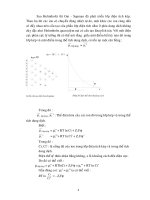
WAVE TROCHOIDS
Although each wave has a forward motion, each particle of water at a wave's
surface moves in a circular orbit of which the diameter is equal to a wave
height (see Figures 10.1 (a) and (b)) The result is that at the crest the motion of
each particle is forward and at the trough it is backward relative to the waves
motion. Below the surface the water particles take up similar orbits
diminishing in size with the depth until. at a depth equal to the wavelength,
there is practically no motion due to the waves. The shape of this wave is
described as a trochoid. Quite simply, a trochoid is the pattern which would be
traced out if some kind of marker were to be fastened to the spoke of a wheel;
if the wheel was then rolled along a flat surface next to a wall, a pattern as
illustrated in Fig 10.1 (a) would be produced.
This shows in elevation a cross section through a simple wave. The
numbered arrows indicate the motion of a particle of water, or cork floating on
the surface, as the wave form progresses in the direction indicated. Figure 10.
1 (b) shows that the cork describes a circle, but does not in fact move away
from its mean position at the centre of the circle. The circular motion
decreases rapidly with depth.
WAVE COMPLICATIONS
In the open ocean, except perhaps in the case of a directional swell with no
wind. the waves in any particular system are almost never uniform in their
characteristics although their motion is always to leeward. When a wind starts
to blow, trains of waves are created and move to leeward but, due to the wind
turbulence and other factors, each wave train usually contains waves of
differing length, period and height, the result being an irregular mixture in
which only a few well-formed waves stand out. Another complication arises
when sea waves and swell waves are present together, sometimes from the
same direction. at other times from totally different directions. In such cases it
may be difficult to establish sea and swell and synchronism may cause some
of the waves to be very large.
77
Chapter TEN
WAVE GROUPS
Wind-generated waves travel in groups, where large waves are continually
overtaking smaller waves. This fact is important in handling a ship in heavy
seas. The behaviour of a vessel depends to a great extent on her period of roll
and pitch.
When the period of roll is less than the period of the wave the ship will tend
to align her decks with the slope of the wave. A violent motion may result but
little water will be shipped.
If the period of roll is greater than the period of wave, the ship tends to dip
her deck edge into the wave and to ship water whilst rolling more easily.
A dangerous condition can arise with the waves abeam when the period
of roll is the same as the period of the wave. Synchronisation may result
in the ship being rolled over.
In large merchant ships the period of roll is greatly in excess of the longest
wave periods. On very small craft, however, with much shorter periods,
synchronisation is a definite possibility. Since waves travel in groups,
however, a series of individual waves all having the same period is an unlikely
occurrence.
78
Chapter TEN
WAVE DIMENSIONS
A wave of a period of 2 seconds would have a length of about 6 metres and if
the period were 10 seconds the length would be about 155 metres. These
waves could be expected to have maximum heights of about 0.6 metres and 12
metres respectively. A long swell, however, with no wind present might have a
period of 15 seconds and length of about 335 metres but a height of only 0.3 metres
or so. The maximum wave height recorded to date is 25 metres.
The size of waves depends also on the duration of blow. Initially the waves are
short and steep but if the wind continues to blow from the same direction they
gradually become longer, and their heights increase. The high seas of the Roaring
Forties for example are generated by fairly consistent strong winds of virtually
unlimited fetch.
OCEAN WAVES IN SHOALING WATER
When an ocean wave comes into shallow water. beginning at a depth of half the
wavelength. its speed and length is reduced though its height stays the same. but
the wave breaks when the depth is about 11/2 times its height. When approaching a
beach at an oblique angle a wave tends to change its direction so that the advancing
edge or front becomes parallel to the beach. It is important to remember that in
relatively shallow and enclosed areas such as the North Sea and the Baltic.
although the waves are unlikely to obtain oceanic dimensions, they are at times
steep and short and therefore dangerous.
Certain waves such as the semidiurnal tidal waves, seismic waves (termed
Tsunami in X Pacific) caused by submarine earthquakes or eruptions, as well as
some of the so-called "tidal waves" moving ahead of or behind tropical storms,
have such long periods that they are unnoticed in mid-ocean and the effect, which
is sometimes disastrous, is only felt when they get into shallow water.
TIDAL STREAMS
A tide flowing against the wind (weather tide) will often cause waves to heap up
and break at the crest. A lee tide tends to flatten the sea.
Tidal races can be hazardous as the seas produced tend to be confused.
Such areas are indicated on charts and in sailing directions. The waves in a race
often arrive from several directions with little warning. The very strong currents
experienced in some tidal races (e.g., the Portland Race and the Race of Alderney)
can make it very difficult to con low powered craft.
79
Chapter TEN
FREAK WAVES
When swell and waves are moving in different directions, the crest of several
waves may arrive simultaneously at one point. This can produce a wave of unusual
height in an otherwise moderate sea. Troughs synchronising in a similar manner
will produce what has been described as a "hole in the ocean".
Very steep and dangerous waves are sometimes experienced with southwesterly
winds off the east coast of South Africa south of Durban, in the vicinity of the
Aghulas Current and its inshore counter-current. Investigations are still
continuing into the apparent complete disappearance of a number of ships,
including large bulk carriers. which it is believed may be attributed to this
cause.
PRACTICAL VALUE OF WAVE DATA
Information about wave performance in the oceans is needed for the following
purposes:
1. To assist in the preparation and issue of information of weather routeing for
ships (see Chapter 24).
2. For research into the behaviour of ships in a seaway and into ship designs
generally.
3. For the design and orientation of harbours and breakwaters and design of oil
platforms at sea.
4. To assist in the forecast of wave conditions on exposed coasts (e.g. exposed
anchorages) .
5. For meteorological and oceanographical research generally.
OBSERVING THE WAVES
In the deck log aboard a ship it is customary to record wave conditions
descriptively. e.g., "Slight Sea", "Heavy Swell", etc. Similar phrases are
customarily used in weather bulletins for shipping to describe actual and
forecast waves. A more exact method of describing waves when coding
weather reports for sending to Meteorological Services is to-report their
estimated height and period. Such observations are admittedly difficult to make
with any accuracy from the high bridge of a fast-moving ship, but instructions
are given to the observers by Port Meteorological Officers and some
proficiency can be attained with practice. The synoptic maps, broadcast to
shipping by facsimile, concerning actual and forecast wave conditions. give
height in metres but rarely include period.
80
Chapter TEN
The following tables giving descriptions and approximate equivalent heights
of sea and swell waves ha'-e been agreed by the WMO for international use.
(These tables are not used for coded weather reports and are only intended for
guidance.)
THE BEAUFORT SCALE
This was first produced by Admiral Beaufort in 1808, subsequently he was a
distinguished and long-serving Hydrographer of the Navy. The scale provides a
practical means of estimating the force of the wind from the appearance of the
sea. Originally the categories were related to characteristics of manoeuvring
various categories of sailing ships of the period e.g. 'Force 6 - That in which a
well conditioned man-of-war could just carry single-reefed top sails and topgallant sails'. Although these criteria no longer appear, the 'Sea Criterion' as
defmed by Beaufort for the same wind strength - 'Large waves begin to form;
the white foam crests are more extensive everywhere. Probably some spray' are
unaltered.
Watchkeepers should thoroughly familiarise themselves with the scale.
Wind speeds are stated for a height of 10 metres above sea level.
81
Chapter TEN
82
Chapter TEN
STATE OF SEA PHOTOGRAPHS FOR ESTIMATING WIND SPEEDS
The following photographs illustrate the appearance of the sea corresponding
to the Beaufort wind scale. Their purpose is to assist observers in estimating the
wind speed when making weather reports. The description of the sea is
according to the SEA CRITERION laid down by the World Meteorological
Organisation.
The appearance of the sea may be affected also by fetch (see Appendix 1),
depth of water. swell. heavy rain, tidal streams and the lag effect between the
wind getting up and the sea increasing.
Probable wave heights and probable maximum wave heights have been
added only as a rough guide to show what may be expected in sea areas remote
from land. In enclosed waters, or when near land with an off-shore wind, wave
heights will be smaller and the waves steeper.
Very few ships carry an anemometer, and this would only indicate the
relative wind aboard a moving ship. What is needed is the true wind force and
direction and the Beaufort Scale provides the best method of making this
important observation.
The line of sight at right angles to the wave's line of advance indicates the
true direction of the wind.
Both these observations are relatively easy to make in daylight but dift1cult
on a dark night. especially with light winds. particularly in a fast ship; care and
experience and common sense are needed. using the feel of the wind on the
face or wetted finger, first of all to determine the force and direction of the
relative wind. If the ship's speed is (say) 15 knots and the relative wind is nil
there is a 15 knot wind from right aft. If the relative wind seems to be about 15
knots from abeam, then the true wind is on the quarter. about 20 knots (fresh
breeze). This can be solved fairly simply from a vector triangle, one side being
the ship's course and speed. another side the direction and speed of the relative
wind, the third side will be the direction and speed of the true wind. (See
Marine Observer's Handbook, supplied free by the Meteorological Office to all
British Selected ships and containing a Table for converting relative to true
wind by inspection.)
83
Chapter TEN
QUESTIONS:
1. Define each of the following terms in relation to ocean waves: Length.
Period, Height, Speed.
2 If the wave period (an average of several observations) was found to be 5. 4
seconds, find its approximate speed and length. (Ans. Speed C = 17 knots.
Length L = 44 metres.)
3. Describe the effects of fetch, duration of blow tidal streams and shoaling
water on: (a) Sea waves. (b) Swell.
4. List some of the practical uses to which wave data is put by meteorological
and other authorities ashore.
5. Ship handling in heavy seas: (a) Describe how different wave periods can
affect a ship's behaviour. (b) What action can be taken to avoid or modify
dangerous rolling?
84
Chapter TEN
85
Chapter TEN
86
Chapter TEN
87
Chapter TEN
88
Chapter TEN
89
Chapter TEN
90
Chapter TEN
91
Chapter TEN
92
Chapter TEN
93
Chapter TEN
94
Chapter TEN
95
Chapter TEN
96