ddc sd sitedesignmanual
Bạn đang xem bản rút gọn của tài liệu. Xem và tải ngay bản đầy đủ của tài liệu tại đây (23.61 MB, 134 trang )
SUSTAINABLE URBAN
SITE DESIGN
MANUAL
Prepared for:
NYC Department of Design & Construction Office
of Sustainable Design by
Gruzen Samton Architects LLP with
Mathews Nielsen Landscape Architects PC
June 2008
photo: Mathews Nielsen Landscape Architects
The Sustainable Urban Site Design Manual offers an introduction
to more environmentally, economically, and socially responsible
urban site design practices for New York City capital projects. It is
conceived as a resource handbook, featuring chapters that marry
the unique site conditions encountered on many City projects with
appropriate sustainable site design strategies. The contents are
addressed to the whole rainbow of NYC DDC project participants,
from City administrators to architects and their consultants, to
construction managers, contractors, and facility personnel.
EXECUTIVE ACKNOWLEDGEMENTS
Honorable
Michael R. Bloomberg
Mayor, City of New York
David Burney, FAIA
Commissioner, NYC Department of Design and Construction
DDC Architecture and Engineering Division:
David Resnick, AIA, Deputy Commissioner, Structures Division
Margot A. Woolley, AIA, Assistant Commissioner
John Krieble, RA, Director, Office of Sustainable Design
Bruce Hendler, RLA Chief of Landscape Architecture
Kerry Carnahan, Office of Sustainable Design
sustainable urban site design manual
table of contents
1. Overview
Introduction
NYC Environmental Challenges
Climate Change and the Future
page
1
2
4
2. Sustainable Sites for DDC
Relevance to NYC Department of Design and Construction
DDC Site Design Types
This is What I Have, so Now What?
Sustainable Urban Site Planning
How to Use This Manual
9
10
12
14
18
3. Maximize Vegetation
Issues and Benefits
Laws, Rules and Regulations
LEED™ and Vegetation
Key Issues of Planting in NYC
Techniques for Maximizing Plant Benefits
Resources
19
21
22
22
29
42
4. Minimize Site Disturbance
Issues and Benefits
Laws, Rules and Regulations
LEED™ and Site Disturbance
Key Issues in Minimizing Site Disturbance
Techniques for Minimizing Site Disturbance
Resources
Understanding Soils
47
48
51
51
55
67
68
5. Water Management on Urban Sites
Issues and Benefits
Laws, Rules and Regulations
LEED™ and Water Management
Stormwater Management – Key Issues
Techniques for Stormwater Management
Water Efficient Landscaping – Key Issues
Techniques for Water Efficient Landscaping
Resources
75
76
78
78
81
97
97
100
6. Materials in Site & Landscape Design
Issues and Benefits
Laws, Rules and Regulations
LEED™ and Site Materials
Light-colored Paving and Hardscape
Strategies for Incorporating Recycled Materials
Specific Techniques and Recycled Materials
Resources
Planted Roofs: See Separate Document
Please see DDC Cool & Green Roofing Manual
available on DDC’s Sustainable Design website
105
107
109
109
111
113
124
photo: Mathews Nielsen Landscape Architects
overview
OVERVIEW
In recent years, New York City’s population and need for public facilities has grown considerably, and is
expected to continue to grow. NYC Department of City Planning projects New York City will grow by more
than 200,000 by 2010, and the City’s population will surge past nine million by 2030. Though the City
and its population will continue to grow, its land mass will not – meaning building sites will increasingly
be at a premium, and the need to design them intelligently will become paramount.
Additionally, with increasing frequency, the City will need to use less desirable sites – some with significant
environmental constraints - or re-use available sites.
On behalf of nearly all other New York City agencies, the Department of Design and Construction (DDC)
serves as de facto Project Design and Construction Manager. In this capacity, DDC works with a portfolio
of publicly-owned property. In this densely populated urban area, each acre of this property is a public
treasure. When buildings are constructed, DDC strives to manage their sites to meet functional needs,
make the most of their unique environmental features and protect them for the benefit of New Yorkers.
With an average annual building construction/renovation budget of approximately $500 million, DDC’s
goal is to approach each project as an opportunity to demonstrate sustainable practices, and to address
the myriad environmental challenges of building in the city.
This manual addresses landscape opportunities associated with building projects. It was developed
for the Structures division of DDC, the group that manages the design and construction of City
buildings. The document highlights sustainable site design practices for their Project Managers and
Consultants – and it does so by focusing on practical recommendations for site land uses, controlling
site disturbances, managing stormwater and other hydrological resources, and landscape planting. In
turn, these recommendations are linked to site typologies common to DDC building sites – and possibly
to a broader City audience, as NYC modifies its practices in line with the goals of PlaNYC 2030.
It is important to note that there is a companion manual developed for the Infrastructure division of
DDC, a separate group that manages design and construction of streetscape and public right of way
projects. High Performance Infrastructure Guidelines was prepared in 2005 with the Design Trust for
Public Space. This handbook presents Best Management Practices, practical strategies and technical
resources for sidewalks, roadways, utility projects – and their adjacent landscaped areas. The scope is
different and the site issues broader, but the goal of both handbooks is to help project teams achieve
greener results. High Performance Infrastructure Guidelines is available on-line at />
d dc sus ta inable urba n sit e s | OV ERV IEW
photo: Mathews Nielsen Landscape Architects
ddc/html/ddcgreen/documents/hpig.pdf
1
nyc environmental challenges
Good site design in New York City requires an understanding of the City’s unique conditions and
environmental challenges. The same factors that make NY energy-efficient – e.g. density, public
transportation, extensive infrastructure – make it unsuitable for many typical site planning and landscaping
strategies. Strategies must be tailored the City’s climate conditions, such as cold winters and intense
rainfall events. Often it is not environmental criteria that determine a building’s orientation and placement
on a site, but the street grid, site shape and zoning. Access options are frequently limited. Open areas,
otherwise suitable for planting, may be shaded by neighboring buildings.
However, with ingenuity and careful planning, site design can be instrumental in improving the
comprehensive environmental performance of projects, as well as enhancing and restoring urban
ecological systems. DDC strives to encourage site design strategies that not only create beautiful, healthful
properties, but also help to address citywide environmental issues. A summary of these key challenges
follows.
Climate Change: The New York area has already experienced warmer, more unpredictable weather
and rising sea levels. Anticipated impacts from natural forces affected by climate change include
longer periods of heat, drought, more frequent and severe storms, loss of coastal wetlands, beach and
soil erosion, increased localized flooding and water quality degradation. Without action, impacts will
continue to intensify. This manual explores site-related strategies that can help mitigate some of these
conditions.
d dc sus ta inable urba n sit e s | OV ERV IEW
as 5 to 10 degrees hotter than the surrounding
countryside. This phenomenon, known as
the Urban Heat Island effect, results from
several factors, including the relative dearth
of vegetation in cities, the preponderance
of heat-absorbing dark roofs and paving
materials on roads and parking areas, and
the accumulation of hot exhaust gases and
engine heat from cars, trucks and buses.
These dark surfaces and lack of vegetation
work together to compound the problem: the
dark surfaces absorb the heat, and the lack of
vegetation limits the natural cooling that the
shade of living plants provide.
2
photo: NASA
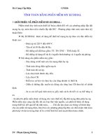
Urban Heat Island (UHI): Cities are as much
Areas devoid of vegetation (map right) indicate the areas of warmer
temperatures (map on the left)
The UHI effect damages the environment in a number of ways. Higher urban temperatures increase the
demand for air conditioning, resulting in higher energy consumption and power plant emissions. When
it is hottest, air conditioners consume much more energy, causing a corresponding increase in the heat
they discharge (rejected heat), which further raises urban temperatures. A hotter City means more air
pollution, because older, less efficient power plants are needed for energy production at peak times, and
ground level ozone is more easily produced at higher temperatures. More heat also means more water use
for infrastructure, landscaping and personal use.
Combined Sanitary / Stormwater Sewer System: New York City is surrounded by water, and its
adjacent rivers and water bodies are particularly vulnerable to both local and regional pollution. Despite
major gains in its water quality over the past few decades, New York City still faces a critical hurdle;
approximately 70% of the City’s 6,300 mile sewer system consists of combined sanitary and stormwater
sewers. These combined sewers become overwhelmed during intense rainfalls, and 27 billion gallons
of “combined sewer overflows” (CSOs) are discharged into the City’s receiving waters each year. The
strategies contained within this document can help reduce, control, and treat stormwater runoff as close
to its source as possible so that CSO events and their polluting effects are minimized.
Water Supply: Conserving water within open spaces and planted areas is as important as controlling flow
off-site. New York City relies on over 1.1 billion gallons of water per day supplied from upstate reservoirs;
water conservation is a crucial objective to ensure the long-term viability and supply of our high-quality
water.
courtesy: Metropolitan Waterfront Alliance
Density and Limited Land: New York City is the densest
U.S. city, averaging approximately 27,000 people per
square mile. Consequently, buildable land often comes in
small parcels, on which the building occupies most of the
site. While there is City-owned land in parks and open
areas, most of the projects DDC develops and manages
on behalf of other City agencies are located in urban
neighborhoods. In these circumstances, environmental
site planning requires a neighborhood approach. When
every property has a little bit of open land, significant
benefits are gained when those little bits are linked
together to create one continuous, usable open space.
Continuity and connectivity form natural networks that
support biodiversity, wildlife habitats, soil remediation and Combined sanitary/stormwater sewer outfall
provide hydrologic benefits. Even on the most developed
site, where every trace of nature seems to have been obliterated, fragments of land can be joined so that
natural systems can be re-introduced and encouraged. This manual suggests some techniques useful
for small, limited parcels. (Another DDC document, Cool and Green Roofing Manual, discusses rooftops as
potential urban open spaces.)
Inadequate space for root development
d dc sus ta inable urba n sit e s | OV ERV IEW
Less than Optimal Soils: Getting trees and plants to
grow in New York City is a challenge. Two of the most
significant obstacles to plant growth are small soil volume
and compaction caused by competition for root space
with utilities and other subsurface appurtenances, and
the weight of pavement and constant traffic, which lead to
poor soil aeration and drainage. Under these conditions,
trees and plants simply stop growing and become
more susceptible to drought, pests and diseases. Soil
compaction leads to stunted, drought-stressed plants due
to low oxygen concentration, decreased rooting volume,
and moisture irregularity. Compacted soils have lower
infiltration rates than undisturbed soils and are more prone
to erosion and sedimentation. On some sites the soil is
further compromised by contaminants, such as acids
and lime, resulting from poor construction and building
maintenance practices, and in some cases the illegal
dumping of hazardous chemicals.
photo: Mathews Nielsen Landscape Architects
Hostile Plant Environment: The urban environment is stressful for trees and plants. Air pollution,
limited space for root development, poor and compacted soils, physical hazards from people, vehicles,
dogs and bikes, physiological threats from pests, and limited sunlight and water contribute to the
difficult environment in which urban plants try to thrive. Identifying strategies that optimize the viability
and survival of plants and trees is critical to our City’s future. This manual offers sustainable planting
techniques to maximize all types of vegetation including recommendations for soil testing, soil types, root
space requirements, spacing and suggested plant lists for different conditions.
3
within the bounds of our limited space, we also build “down.”
Subways, tunnels, utilities, communications cables, and water pipes,
all exist below street level in a complicated, dynamic network. Despite
the myriad advantages to building underground, a complex subsurface
condition can create significant site planning and design constraints
for architects and landscape architects developing projects on the
surface. Given the age and vulnerability of NYC’s sewer and water lines
to vibrations and tree roots, and the potential for construction-related
damage, it is imperative to know what’s under the surface of your site
(and adjacent) in order to avoid damaging critical infrastructure. For
this reason, projects are subject to regulations and review by many City
agencies, particularly the Department of Environmental Protection.
photo: Mathews Nielsen Landscape Architects
An Underground City: In New York City, just as we build “up”
Subsurface utilities limit tree planting
climate change and the future
The following text is quoted from Inventory of New York City Greenhouse Gas Emissions, April 2007:
The term “global climate change” refers to the destabilizing impact on climate and weather patterns that result
from continuous addition of greenhouse gases, the resultant increase in heat energy in the earth’s atmosphere,
and the associated changes that follow. Even small changes in the average temperatures can be accompanied
by an increase in severe weather events such as storms and droughts, ecosystem change, loss of animal and
plant species, stresses to human health, and alterations in regional agricultural productivity.
Although climate change is a global issue, the effects of rapidly rising temperatures will be felt in every local
community. Average temperatures in New York State are projected to increase between 2°F and 8°F by 2100,
with the largest increases in coastal regions such as New York City. Average precipitation is also expected to
rise by 10 to 20 percent, with extreme wet and snowy days becoming more frequent. Intense weather trends will
be felt on the opposite end of the temperature spectrum, as the occurrence of summer days with temperatures
above 90° are expected to multiply from 14 days in 1997-1998 to 40-89 days by the 2080s.
d dc sus ta inable urba n sit e s | OV ERV IEW
The list of threats associated with global climate change is alarmingly long, and encompasses effects
on air, water, and vegetation. Certainly not all of them can be addressed within the context of individual
projects, but site designers should recognize potential impacts and design to help mitigate them. The
site strategies offered in this manual take into account pertinent considerations for ecosystem health,
water supply and quality, and the Urban Heat Island effect.
4
PlaNYC 2030, the City’s strategy for making our city better, more green and more livable, attempts
to reduce NYC’s global warming emissions by 30% with city-wide initiatives that address policy and
infrastructure, and encourage individual building projects to do their part.
climate change and ecosystems
The effects of climate change on biodiversity and ecosystems are impossible to separate from the
effects of other stresses, such as pollution, atmospheric levels of carbon dioxide, land management
and use trends. To date there is no conclusive evidence that climate change alone will have an adverse
impact on the survival of plant and animal habitats. There are examples that many scientists attribute
to global warming, such as the fact that flowering plants are blooming about 5 days earlier per decade,
birds are laying eggs sooner, and maple syrup production from sugar maples has shifted from northern
New England to Canada.
In general, global warming has caused the slowly creeping polar migration (northerly for the U.S.)
of a plant or animal’s habitat. Thus climate change could benefit certain plant or insect species by
increasing their ranges. The resulting impacts, however, could be positive or negative depending on
whether these species are invasive. For example, climate change could have potentially devastating
impacts on agriculture and forests if pest species are decoupled from their controlling prey, or if the
ranges of animals responsible for seed dispersal become disjointed.
Climate change will affect individual wetland ecosystems largely through changes in precipitation,
erosion, rising sea level, and temperature fluctuations. Wetland plants and fauna are extremely sensitive,
such that even minor variability of moisture storage can adversely affect plant and animal diversity and
microbial activity.
In New York, as well as in other parts of the country, the Climate Zone classification for plant hardiness
has shifted, increasing in NYC from 6A (minimum temperature -10° F) to 6B (minimum temperature
-5° F). This is good news from the standpoint of broadening the range of plant material that can survive
NYC winters. However, plants like poison ivy become more toxic, ragweed produces more pollen,
and Northeastern urban forests may soon have to contend with Kudzu, which has swallowed whole
woodlands in the South.
climate change and water
As a coastal city, New York is particularly susceptible to the effects of global climate change. Rising
sea levels and higher risk of severe floods and storms pose a potentially devastating threat to sites
located within floodplains and sites with deteriorated shorelines. Sea levels along much of the New
York coast have been rising at an average of ¼ inch per year. If this trend continues, within the next 75
years sea levels surrounding New York will have risen more than 18 inches. Such a rise would result in
complete inundation of areas currently mapped within the 100-year floodplain. Other serious degradation would occur in coastal wetlands, beaches, fresh water lakes and rivers. The statistical probability
of a “100-year storm” has already become a once in 80 year event and may progress to a once-in-43 year
event by 2020 and by 2050, a once-in-19 year event. Looking ahead, DDC will be taking a more critical
look at sites and building locations near the water and flood plain, recognizing that the effective limits
of the 100-year flood plain are likely to expand. For updated maps of flood-prone areas in New York City,
see the NYC Department of Buildings (DOB) Flood Insurance Rate Maps 2007 on the DOB website.
DEP’s Climate Change Program published its Assessment and Action Plan in May 2008. In this report,
NYCDEP Commissioner Emily Lloyd states: “The impacts of climate change will be pervasive and profound. Most natural and man-made systems will be affected, and the City of New York’s water supply,
drainage, and wastewater management systems are no exception . . . the time to take action is now.”
More severe and frequent rainfalls will exacerbate
combined sewer overflows (CSOs), causing greater
pollution of surrounding rivers and estuaries. In New
York City, the prevention of combined sewer overflows
is already a priority, and there are detention regulations that cover all areas with constrained sewer capacity. Site and landscape strategies include increasing permeable surfaces, employing bio-retention, and
capturing rainwater for reuse. Specific planning and
design techniques are discussed in the Stormwater
Management chapter, with diagrams and details of
practices.
d dc sus ta inable urba n sit e s | OV ERV IEW
The City’s water system could be affected by increased evaporation of water due to warmer temperatures, which would reduce river flows and lower lake and reservoir levels, particularly in summer when
demand for water is at its highest. Higher temperatures and more violent storms could lead to increased
turbidity of reservoirs thereby decreasing water quality.
5
new york as an urban heat island
As global and local temperatures rise, mitigation of the Urban Heat Island (UHI) effect will become critical
in NYC, as an increase of air temperature of only 6° to 8° F can trigger a range of public health problems,
particularly for children, the elderly and people with respiratory ailments. Also, since NYC chronically faces
shortfalls of electrical capacity at peak demand, the UHI effect encrease the risk of brown-outs or blackouts.
More vegetation, especially trees, is a key remedial approach for site and landscape architects seeking to
minimize the UHI effect. Plants provide natural cooling in several ways –by providing shade, by utilizing the sun’s energy in photosynthesis, and, most importantly, by evapotranspiration, which is similar to
perspiration. When plants transpire, they turn water into vapor, dissipating the latent heat of vaporization
and providing cooling.
Though studies (see below) have shown vegetation plays a more important role in UHI mitigation than
light colored surfaces and other physical factors (height, orientation to prevailing winds etc.), these strategies are synergistic when combined with planting. Planting – along streets, in open areas and on rooftops
– combined with other strategies, such as replacing dark surfaces with lighter colored ones, offers more
potential cooling than any other individual site design measure.
NYSERDA, with Columbia University Center for Climate Systems Research & NASA Goddard Institute
for Space Studies, Hunter College Department of Geography, and the Science Applications International
Corp., sponsored a study in October 2006 of NYC’s heat island and ways to mitigate it, entitled Mitigating
New York City’s Heat Island with Urban Forestry, Living Roofs, and Light Surfaces.
Effective city-wide mitigation strategies – identified by NYSERDA in descending order of individual effectiveness as street trees, living roofs, light-colored surfaces and open space planting – can and should
be used together when possible for DDC projects. Site design and construction strategies that work to
maximize cooling are given special attention in this manual.
Wind
Convective
Heat Transfer
Solar Radiation
Thermal
Radiation
(Infrared)
Reflected Radiation
d dc sus ta inable urba n sit e s | OV ERV IEW
Pavement Surface
6
Heat Conduction
Between Layers
Heat Conduction
Between Layers
Heat Conduction
Between Layers
Pavement Base
Pavement Subbase
Subgrade (Ground)
Demonstration of reflectivity, conductivity, and emissivity
that can contribute to the urban heat island effect
urban heat island strategies for ddc
Mitigation Scenario
Reference
Use light colored
surfaces
· Use light colored pavement
· Use light roof surfaces
Maximize vegetation Landscape
· Plant street trees
· Plant trees in open spaces and sidewalks
· Maximize other planting and minimize
hardscape
· Use open-grid paving techniques
· See Maximize Vegetation
chapter
Maximize vegetation Living Roof
· Use green roof technology
· See DDC document Cool &
Green Roofs
Provide Shade
· Plant trees
· Use green screens, other plantings
· Locate paved areas in building shadow,
under overhangs etc.
· See Maximize Vegetation
chapter
Use porous pavement
· Minimize heat storage through use of
porous pavements
· See Stormwater
Management chapter
(high albedo)
· See DDC Cool & Green
Roofing Manual
· See Light Colored Paving in
Materials chapter
d dc sus ta inable urba n sit e s | OV ERV IEW
Strategy
7
resources
climate change
·
PlaNYC 2030 A Greener, Greater New York, Mayor’s Office of Long Term Planning and
Sustainability, May 2007 />
·
Inventory of New York City Greenhouse Gas Emissions, Mayor’s Office of Long-term Planning
and Sustainability, April 2007
HotNY.pdf
· Climate Change Program Assessment and Action Plan, NYC Department of Environmental
Protection, May 2008 />
·
·
·
·
·
Global Warming & Rising Oceans: www.actionbioscience.org
Climate Change 2001: Impacts, Adaptation and Vulnerability www.grida.no
Ecosystems and Biodiversity />Effects of Global Warming />“A Wetlands Climate Change Impact Assessment for the Metropolitan East Coast Region”:
www.metroeast_climate.ciesin.columbia.edu/reports/wetlands.pdf
·
“Impacts of sea level rise in the New York City metropolitan area” by Vivien Gornitz, Stephen
Couch and Ellen Hartig, Global and Planetary Changes, Vol. 32, 2002
urban heat island effect
·
Mitigating New York City’s Heat Island with Urban Forestry, Living Roofs, and Light Surfaces,
NYSERDA, October 2006
·
“Cooling the Blacktop” by Meg Calkins. Landscape Architecture Magazine, pp 53- 61. February
2007.
·
·
·
US EPA Heat Island Reduction Initiative: www.EPA.gov/heat island/strategies/index.html
“Features Favored by Mother Nature”: www.concreteparking.org/environmental.htm
“Heat Island Effect”:
ActionsLocalHeatIslandEffect.html
·
“Air Pollution Prevention Through Urban Heat Island Mitigation”: www.ghcc.msfc.nasa.gov/
uhipp/epa_doc.pdf
·
·
“Sustainable Site Design Philosophy”: www.nps.gov/dsc/dsgncnstr/gpsd/ch5.html
“Sustainable Sites: The Case for a Site-Only LEED” by Mike Abbate, The American Society of
d dc sus ta inable urba n sit e s | OV ERV IEW
Landscape Architects and the Ladybird Johnson Wildflower Center, August 2005.
8
·
Cool and Green Roofing Manual, NYC Department of Design and Construction, June 2007:
/>
© Jeff Goldberg/Esto
sustainable sites
for ddc
SUSTAINABLE SITES FOR DDC
In New York City, population growth and proliferation of new buildings have increased the need for
ingenuity in site planning and design to maximize the human and environmental benefits. The Department
of Design and Construction and other City agencies are taking a leadership role in encouraging and
supporting sustainable site design and landscaping.
All City projects are informed by PlaNYC 2030, the Mayor’s April 2007
comprehensive sustainability plan for a greener, greater New York.
PlaNYC targets five key dimensions of the City’s environment – land, air,
water, energy and transportation. The intent of this integrated approach
is to help ensure a higher quality of life for future generations, and help
reduce NYC’s global warming emissions. Site and landscape design are
an integral part of the approach and proposed initiatives - specifically
those for land and open space, water quality and air quality.
With the enactment of Local Law 86 of 2005, the City now requires
most of its projects to meet the Silver level of the LEED™ certification
process of the U.S. Green Building Council (USGBC), as well as specific
energy and water efficiency requirements. Site planning, landscaping
and related material choices can contribute to possible LEED-NC
credits in Sustainable Sites, Water Efficiency, Energy & Atmosphere,
and Materials & Resources. Each section of this manual highlights
applicable LEED™ strategies. DDC’s Project Timeline for LEED/Local
Law 86 of 2005 and related documents are available on the DDC’s
Sustainable Design website.
·
·
·
·
·
Wide range of sites / wide range of facility types. DDC’s projects range from buildings on
parkland, to police stations on tight urban lots, to childcare centers with play yards. And as
the City grows, DDC is often forced to build on more problematic properties. No universal
approaches will work, so this manual is organized to address the basic issues, and suggest a
menu of appropriate solutions for different types of sites;
Agency regulations and laws. City, State and Federal agencies hold jurisdiction over specific
aspects of site design, with a complex network of regulations and laws. Applicable laws are
noted in each section, with reference to more information;
Inexperienced consultants. Some consultant teams are unfamiliar with sustainable site
approaches. This is due either to inexperience with site/landscape technologies, and/or to the
lack of a professional landscape architect on the Consultant Team. We recommend that each
project have a landscape architect on the design team, and this manual is meant to augment
the broader team’s knowledge with specific sustainable approaches;
Bad timing. Often landscape design services lag behind the building concept, whether
because survey information is not available or the landscape architect does not participate
in the early stages of planning and design. A sustainable site approach requires early input
by the landscape architect. It is very important to note that topographic surveys and soil
profile studies are available through DDC at no cost to the project, however, if they’re going to
help guide site design and gain approvals, they must be requested as soon as a client Agency
circulates its scope;
Lack of coordination. Opportunities are lost, and mistakes made when project team
members do not understand the considerations of each participating discipline.
d dc sus ta inable urba n sit e s | DD C SI TES
Because DDC’s client base and project portfolio present an array of unique site conditions, it is impossible
to offer prescriptive site design solutions here in this manual. Rather, the document is written to provide
a framework for DDC project personnel to discuss and promote sustainable site design principles within
their own projects, and to specifically address challenges and obstacles commonly encountered on DDC
projects, such as:
9
ddc site design types
The City agencies DDC serves perform a wide variety of functions in all five boroughs; accordingly, landscape design opportunities range from open, vegetated sites to very tight urban sites. DDC is responsible for built projects in the many parks and the botanical gardens, as well as for civic buildings located
within varied NYC neighborhoods, including police stations, daycare centers, courthouses and others.
Most DDC projects can be characterized into one of the following typical design types:
·
·
·
·
·
·
d dc sus ta inable urba n sit e s | DD C SI TES
·
10
·
·
·
·
·
Building on a Campus
Characterized by a campus site several buildings on one property, connected by
driveways, walkways, utility services and landscapes;
NYC Examples: Crossroads Congregate Care Facility, Snug Harbor Cultural
Center, Lion House at the Bronx Zoo, Gateway Estates;
Opportunities for sustainable site design include stormwater management
techniques that require large sites such as wetpools and wetlands, berms and
slope reduction benches, large infiltration areas; maximize vegetation including
habitat restoration, shelterbelts, and meadows; use materials that incorporate
recycled content, particularly for roads, paths and parking; site protection
techniques that limit construction vehicle access and staging and protect zones
of existing vegetation.
Congregate Care Facility
Building in a Park
Characterized by a campus site in which landscape and parkland are a priority
feature. Utilities may not be readily available;
NYC Examples: Queens Botanic Garden, NY Hall of Science, Central Park
Precinct, Queens Museum, Hunts Point Community Center, Rose Center
Planetarium;
Opportunities for sustainable site design include stormwater management
strategies suitable to medium scale sites, such as storage and infiltration beds
integrated with parking lots, bioretention areas and pervious paving; maximize
vegetation by expanding contiguous landscaped areas and creating buffers of
planting to mitigate harsh climate conditions; incorporate recycled content in
products such as perimeter fencing, wheel stops, pavements and pavement
subbases; use site protection techniques that limit disturbance in areas to be
planted, amend rather than import new planting soil, and protect soil from
erosion.
Queens Museum
Lot line Building
Characterized by extremely constrained open space, frequently not more than
perimeter sidewalks, a small entry plaza and perhaps a rear yard;
NYC Examples: Bridges Juvenile Center, Pike Street DEP facility, Remsen Avenue
DEP facility, Engine Co. 277, Lenox Hill Senior Center, 9th Precinct;
Opportunities for sustainable site design include stormwater management using
pervious pavements, structural soil, planters, catch basin inserts and vegetated
roofs; maximize vegetation by planting street trees and planters adjacent to entry,
using vine screens on appropriate walls; use materials that incorporate recycled
content particularly for pavements, furnishings and green roof systems; minimize
site disturbance by protecting existing street trees.
Pike Street
DEP Facility
Building with a Plaza
Characterized by a paved open space accessible to the public;
NYC Examples: OEM Headquarters, Aaron Davis Hall at CCNY, Brooklyn Central
Library, Glen Oaks Branch Library, Bronx County Hall of Justice;
Opportunities for sustainable site design include stormwater detention tanks,
permeable pavement, trees to maximize shading of plaza, light-colored pavement,
grey water capture and reuse for irrigation.
OEM Headquarters
·
·
·
·
·
·
Courtyard Building
Characterized by a protected outdoor area, enclosed or semi-enclosed
by the building. Many serve as recreation areas for the facility’s users.
NYC Examples: Williamsburg Community Center, Williamsburg Day
Care, El Museo del Barrio, PS 1 Museum, Richmond Hill Group Home;
Opportunities for sustainable site design include small scale
stormwater filtration devices, using native and drought tolerant
plants, use of trees to shade public plaza and west walls; use of high
albedo pavements and those that contain recycled content.
El Museo del Barrio
Building Surrounded by Parking
Characterized by surface parking requirements that leave little site area
for landscaping or outdoor functions;
NYC Examples: Metropolitan Transportation Authority Corona
Maintenance Facility, 120th and 121st Police Precincts, Queens Hospital
EMS Station, Randall’s Island Fire Training Facility, Rockaway Fire and
EMS Station;
Opportunities for sustainable site design include deploying stormwater
management strategies requiring minimal site area such as rain
gardens, planters catch basin inserts and infiltration swales; maximize
vegetation by planting street trees, adding trees to plazas and other
paved surfaces to create shade; using permeable and light-colored
paving, incorporating materials that contain recycled content particularly
for paving systems and site furnishings; minimize site disturbance by
protecting existing trees, staging construction away from future planted
areas and preventing contamination to existing soil areas.
121st Precinct
Building on an Irregularly-Shaped Site
·
Sunrise Yard
Building Adjacent to Water
·
·
Characterized by low-lying land, typically comprised of landfill and
sloping topography or constructed edge adjacent to a river or estuary;
NYC Examples: Harper Street Yard on Flushing Bay;
Opportunities for sustainable site design include maximizing
vegetation as a strategy for shoreline restoration, wetland and filtration
techniques to filter and slow stormwater runoff, various construction
impact mitigation techniques, as well as others that are required by
regulatory agencies.
Harper Street Yard
Native plants can be used in all design types, for lower maintenance and more ecological value.
d dc sus ta inable urba n sit e s | DD C SI TES
·
Characterized by areas of “leftover” property, and/or awkward circulation
patterns;
NYC Examples: Sunrise Yard Maintenance Yard, George Vierno
Dormitory, Park Slope Branch Library, Ft. Hamilton Branch Library;
Opportunities for sustainable site design include saving and maximizing
areas of vegetation; introduce pockets of vegetation & trees; employ
various stormwater management techniques; and use of materials
containing recycled content. The opportunities need to be carefully
evaluated based on site shape and the amount of undeveloped land
after the building and site program are defined. Location of the building
on site is key.
11
this is what i have, now what?
So, how does this apply to my project? Below are diagrams of the typical site types that DDC encounters,
highlighting conditions common to them. Because all sites are different, review these samples to identify
the site conditions that apply to your project. Relevant site and landscape strategies are listed in the chart
below, showing where more information can be found in this manual.
#1
#7
#1
#2
EL MUSEO DEL BARRIO
EL REMSEN AVE. DEP FACILITY
Courtyard Building
#6
#7
#5
#1
KINGS BRIDGE BRANCH LIBRARY
Lot Line Building
Lot Line Building
#7
#3
#2
#7
#4
#3
#1
#7
#4
#2
#7
#7
#4
#2
SUNRISE YARDS
Buildings on an Irregular
Shaped Site
#2
121ST PRECINT
OEM HEADQUARTERS
Buildings Surrounded by Parking
Building with a Plaza
#1
#6
#9
#3
#9
#2
BRIDGES JUVENILE JUSTICE CENTER
d dc sus ta inable urba n sit e s | DD C SI TES
Lot Line Building
#5
#1
#3
#10
#9
PIKE STREET DEP FACILITY
Courtyard Building
Buildings on an Irregular
Shaped Site
12
#9
#1
FT. HAMILTON BRANCH LIBRARY
#4
#1
#9
#5
#3
#3
#5
#4
#4 #1
#12
#3
#4
#2
#8
#5
#5
#12
#12
HARPER STREET YARD
QUEENS MUSEUM
Buildings Adjacent to
Water
Buildings in a Park
CONGREGATE CARE FACILITY
Buildings on a Campus
#8
#1
#3
#2
#6
#4
#5
#2
#6
#6
#1
#2
120th STREET PRECINT
BROOKLYN CHILDREN’S MUSEUM
PARK SLOPE BRANCH LIBRARY
Buildings Surrounded by
Parking
Buildings on an Irregular Shaped
Site
Buildings on an Irregular Shaped
Site
this is what i have: typical ddc site conditions
Numbers on the drawings reference numbers on the Site Conditions in the following chart.
Refer To
Pages
Site Condition
Particularly Useful Strategies
1
Sidewalk
Tree pit enhancement; structural soil trenches, recycled
content in concrete
29-33,
43-45,114
2
Entry plaza
Rain gardens, trees for shade; recycled content in pavers;
structural soil, planters
29-32, 87,
88, 91-92,
114, 117
3
Loading dock
Catch basin inserts, water quality inserts; recycled content in
asphalt and base aggregates
86, 119, 122,
123
4
Parking and service area
Trees for shade, bark beds, infiltration areas, recycled
content in asphalt, wheel stops, and base aggregates;
pervious pavement
31, 83-84,
86, 89, 116,
119
5
Front yard
Rain gardens,vegetated buffer, shade trees, infiltration
area, biofiltration techniques,recycled content in mulch/soil
amendments,habitat enhancement, native plants
34, 40,
85-86, 89,
116, 119
6
Narrow side or rear yard
Infiltration swales, vegetated buffers; vine screens and
planted walls, recycled content in fencing
34, 38, 90,
120
7
Land-locked, irregular,
“left-over” area
Amended soils, turf alternatives, native plants; retain
existing vegetation; biofiltration techniques
34, 36, 61,
62, 85-89
8
Steep terrain
Slope reduction bench, turf alternatives, habitat planting;
minimize site disturbance, erosion and sediment control
40, 58-59,
93
9
Courtyard
High-albedo paving; infiltration areas; recycled content in
pavers and furnishings; pervious pavement
83-84,
89,109-110,
111
10
Shoreline edge
Minimize site disturbance; vegetated filter strip, native
plants, habitat enhancement
40, 55, 85,
86
11
Wetland proximity
Minimize site disturbance; native plants, habitat
enhancement; protect existing soils and vegetation,
stormwater filtration techniques
40, 55,
60-63,
87-94
12
Campus condition
Amended soils, turf alternatives, native plants; retain
existing vegetation; biofiltration techniques
34, 36,
61-62, 85,
86
V*
Previously paved
Recycled concrete aggregate or asphalt as base for new
pavement or backfill
V*
Shallow rock or
impermeable soil
Underdrained bioretention, detention structures; reuse of
rock or crushed rock aggregate in landscape and subbase
89-94, 123
V*
Elevation change at entry
Planters; recycled content in mulch and soil amendments
87, 88, 118,
121
V*
Perimeter enclosure
Vine screens, planted walls, windbreak/planted buffer
V* = Various sites
122, 123
37, 38-39
d dc sus ta inable urba n sit e s | DD C SI TES
#
13
sustainable urban site planning
What makes urban site planning “sustainable”? If basic site design already considers physical
characteristics and functional goals, then sustainable planning extends the thinking to incorporate
practices that are sensitive to the environment. A sustainable approach to urban site planning targets
the following:
· Maintain and protect valuable stands of vegetation
· Minimize impacts of run-off to adjacent water bodies
· Reduce contribution to the urban heat island effect by using appropriate landscape materials,
minimizing paved and impermeable surfaces, and reducing energy consumption
· Restore the health of degraded urban sites
· Reduce water consumption and protect water body quality
· Encourage access to public transportation and facilitate non-motorized commuting
Sustainable design also demands interdisciplinary design – a design process in which all professionals
work together from the inception of the project. One of the traditional practices that limits environmental
accomplishments is the separation of “landscape” design, and the landscape professional, from the initial
site planning typically done by the architect. When the landscape architect is brought in later in the design
process, many opportunities have already been lost.
Interdisciplinary design can maximize a project’s green potential if all consultants understand their roles
and start together at the beginning of the project. The whole design team and affected stakeholders
work together through all of the project phases and evaluate the design for cost, quality of life, future
flexibility, efficiency, environmental impact and creativity. It is not useful to bring the landscape architect
on board after the building is sited, just as it is not helpful to wait until major surface areas are identified
before evaluating drainage alternatives with the consultants. Working together also means staying
together for the duration of the project, including the construction and post-construction phases.
zoning and open space
14
In NYC, open space is a precious commodity, and the desire to keep it needs to be balanced with
programmatic demands as well as the bulk and coverage permitted by zoning. Within the LEED rating
system, creation and maintenance of open site areas, especially with native or adapted vegetation, is
encouraged and rewarded. There is a LEED credit for “extra” open space, above that required by local
zoning (NC Credit SS 5.2 ), as well as a credit for using native or adapted vegetation.
Zoning divides the City into three basic types of zoning districts:
Residential (R), Commercial (C) and Manufacturing (M). The maximum
size of a building on a lot in any district is determined by the maximum
permitted floor area ratio (FAR). However, FAR does not determine
where to put the footprint of the building. Each zoning district contains
requirements or yards, building height and setback, and parking. The
New York City Department of City Planning web site offers more detailed
information regarding bulk and other zoning regulations.
/>Many DDC projects are located within commercial and manufacturing
zones. Generally speaking (there are exceptions; zoning must be analyzed
for each site), sites in commercial or manufacturing zones may be built to
full lot coverage at the ground level. Front and side yards are generally not
photo: Mathews Nielsen Landscape Architects
d dc sus ta inable urba n sit e s | DD C SI TES
Zoning is a powerful force in NYC development and construction; it regulates the density, bulk, height
and minimum dimensions for yards and setbacks. These requirements help determine a building’s
location, orientation and shape, especially influential on a tight site If a proposed project is seeking LEED
certification, then open space parameters, density, height, setback, yards, parking and permitted uses
must be considered within the special context of LEED regulations.
required in these districts; a 20 foot rear yard is required above the ground floor. In many cases, buildings
do not use the entire potential “as of right” footprint space, but even at almost or full coverage there are
sustainable landscape techniques that can improve the overall environmental performance, such as street
trees, planters, vine screens, and planted roofs.
integration with the site planning process
DDC provides its consultants with the Design Consultant Guide
[ which is a checklist of services and deliverables, as
well as description of qualitative expectations for a project’s milestones. This Sustainable Urban Site
Design Manual is intended to follow those established tasks and milestones, but not to alter or modify
the contractual responsibilities described in the Design Consultant Guide. Outlined below are suggested
tasks, linked to DDC’s phases of the design process, that will facilitate sustainable site design.
inventory and analysis phase
·
·
·
·
·
The DDC Project Manager
should start the site survey
and subsoil investigation
while waiting for project to be
registered.
Testing. Before beginning the design process, the consultant must request and obtain test results
on the existing soil. By code, new building plans must include borings that quantify the site’s soils
profiles. However this information does not provide information on many other aspects of the
site’s underlying soil. Sustainable hydrologic and landscape planning also must be premised on
tests that evaluate and document the chemical, biological and hydrologic characteristics of the
site’s soils. These tests will aid in determining landscape/planting and stormwater management
and design strategies as well as the budgets for these components. See “Soil Tests” in the
Minimize Site Disturbance chapter for descriptions of suggested tests. Also refer to the USDA
Soil Classification System [http://soils/usda.gov/technical/classification/taxonomy]. DDC has
in-house groups that conduct subsurface investigations and provide topographic surveys at
no additional cost to the project. The agency’s Project Managers are asked to request an upto-date survey and geotechnical profiles immediately upon receipt of a project’s scope from a
client agency. If these investigations haven’t started by the time a project consultant has been
identified they should request them immediately. In this way, the studies can be done by DDC
while the consultant’s contract is being finalized and registered;
Topography. Understanding topography is essential not only for building placement, but also to
plan for drainage and minimize earthwork and disruption to existing site vegetation;
Existing Vegetation: Vegetation needs to be assessed for its quality and viability. Many sites
contain invasive species and monocultural stands of trees. Other sites have mature trees and
significant areas of healthy vegetation. Whatever the case, site vegetation needs to be identified
and mapped. Sustainable site planning techniques mandate the retention of as much existing
native vegetation as possible and the protection of these areas from construction impacts;
Microclimate. In order to help determine the best opportunities for passive solar design and
natural ventilation, diagrams of sun and wind patterns are important to generate before the
final building location is determined. Remember that the “north-south” orientation of the
Manhattan street grid is only a convenience, and the real orientation is shifted approximately
29° from true north toward the east;
Shorelines and Wetlands. Development near aquatic areas must be based on an extensive
understanding of sensitive resources and processes. Sites in close proximity to shorelines
or wetlands are tightly controlled by federal, state and local regulations. Consult these before
doing anything!
d dc sus ta inable urba n sit e s | DD C SI TES
The Site Inventory Phase of a building design project investigates,
quantifies, and documents the existing site characteristics and its
context. The architect, landscape architect and engineers can analyze
and use this data as the factual basis for land use and site design
decisions. For a sustainable approach to site planning and design, we
present these additional considerations:
15
pre-schematic design phase
During DDC’s Pre-Schematic Design Phase, the basic concept of the building is established, after
exploring alternatives and setting design goals. For a sustainable approach, we present these
additional considerations:
· Sustainable Design Workshop: When the results of the site inventory and analysis are available
·
·
·
·
·
and the design program has been established, this meeting should be the first work session –
and it must include all the consultants and the client group. Sharing site evaluation information
will inform the team, and reveal sustainable design opportunities. Some typical site-related
discussion items are below.
Use the Site Wisely: Review and organize site activities such as public spaces, utility corridors
and parking to reduce the building and paving footprints. Limit site disturbance to the minimum
area necessary and coordinate with available infrastructure (utilities and streets). Define utility
corridors early in the design process and coordinate these with any other program elements that
will result in site disturbance.
Drainage Patterns: In our highly urbanized environment it may not be immediately apparent
that there is a natural drainage pattern, other than what can be seen flowing into the nearest
storm drain. On every site there is room for improving the management of its stormwater,
whether by creating vegetated areas to capture, detain and filter runoff, by using permeable
pavement or green and blue roofs to slow runoff, or by using detention tanks.
Solar Orientation: In NYC’s climate, the shoulder seasons of early spring and late autumn
are times when we most enjoy the sunshine. However, in warmer seasons, the site-related
concerns are heat gain, re-radiation of heat into the atmosphere and the energy required to cool
interiors heated by the sun. Optimizing the building’s orientation and associated exterior public
spaces can take maximum advantage of solar orientation to provide shade over such surfaces as
parking and roads that contribute significant heat gain. Coordinate this site-related orientation
analysis with the study of building orientation as it relates to daylighting and interior glare.
Wind and Climate: Characteristics of the local microclimate need to be considered when
locating new structures and exterior public spaces. This will maximize human comfort and
reduce energy usage for heating and cooling. Prevailing winds should be used as natural “air
conditioning.” Assess the impacts of the new structure(s) on wind movement so as not to
create channels that accelerate the wind (Venturi effect).
Vegetation: Discussion of building location and footprint should consider the findings on
vegetation – those areas to be protected, shade and micro-climate, relationship to neighboring
open space (habitat linkage) and any areas of contamination to be mitigated.
16
The development of the site design and landscaping will vary greatly during the design development and
document phases, depending on the nature and scope of the project. For a sustainable approach on all
projects, we present these additional considerations:
· Drawing
Coordination: The site
survey and the project drawings should
be set up using a common coordinate
system before they are distributed as
base plans to the consultants. The
architect, civil engineer and landscape
architect should collaborate on this –
otherwise the project runs a high risk
of encountering progress-delaying
surprises. The architect should not
distribute floor plans that are not
referenced to the survey.
Rafael Vinoly Architects PC
d dc sus ta inable urba n sit e s | DD C SI TES
design and construction document phases
121 st Police Precinct, Staten Island, NY
· Utilities: Coordinate the placement of new utilities with areas of the site to be protected, e.g.
trees, vegetation, natural topography. This should be done during the design development
phase, when the engineers are beginning to lay out the utility lines across the site. Review the
sewer capacity and drainage plan with DEP requirements to ensure that stormwater conveyed to
the sewer system does not exceed the allowable flow and that the project will achieve required
connections.
· Site Access: Vehicular access into a site is a critical decision that needs to be made at the outset,
both to minimize paved areas and plan for drainage and plantings. Use the planned permanent
road as the construction access route.
· Vegetation: Choose plants that are suited to the site conditions and can better survive in them.
City agencies come to DDC for design and construction assistance, but they operate and maintain
their own buildings, so match the plant palette to the maintenance capabilities of the users.
·
Marble Fairbanks Architects and Scape
Plan for Construction: During Contract Document [CD]
production, prepare a site protection and site demolition plan
that specifies the protection of selected specimens or areas of
site vegetation, street trees, environmentally sensitive areas,
and areas susceptible to erosion. Require the contractor to
develop and implement a plan for the recycling of construction
waste. If the site is occupied by a structure or paving, specify
the reuse, salvage or recycling of materials. Prepare an erosion
and sediment control plan per the NY State Department of
Environmental Conservation (NYS DEC) and the requirements
of USGBC LEED™ system.
Glen Oaks Branch Library, Queens, NY
construction phase
The construction phase is a critical phase that requires vigilance on the part of the designer and the DDC
project manager. For a sustainable approach, we present these considerations:
·
·
·
·
·
Be vigilant in the enforcement of specified site protection techniques;
Keep an eye out for field changes to utilities that may alter excavation paths that could adversely
impact existing trees;
Maintain good lines of communication with the construction manager and/or construction
superintendent to protect existing and future planted areas from compaction and soil
contamination from construction activities;
Stay alert to the construction schedule to ensure soil tests are submitted and approved in a timely
manner, that plant material is tagged and ready for installation during the correct planting seasons
and that subsurface and adjacent construction is complete before installing plant material;
Don’t abandon the plants after the project is finished: work together with the client agency/
end user of the site to be sure there are procedures in place to allow the plants to become well
established, watered and replaced, if necessary, during the guarantee period.
d dc sus ta inable urba n sit e s | DD C SI TES
·
Materials for Landscaping and Construction: Specify
environmentally preferable products. The composition of materials used in site construction
is a major factor in their life-cycle environmental impact. During the design development and
construction document phases, research and specify products that maximize recycled content,
materials harvested on a sustained yield basis and assemblies that can be easily deconstructed
at the end of their useful lives. Give preference to locally produced products and other products
with low embodied energy content. Eliminate the use of materials that pollute or are toxic during
their manufacture, use or reuse. Consider trade-offs among life-cycle stages (i.e. raw materials
acquisition, manufacturing, transportation, etc) when determining environmental preferability.
Think about the big picture rather than simply shifting problems from one life-cycle stage to
another.
17
how to use this manual
This manual is intended for both project managers and design consultants who may not have extensive
experience with site design and landscape architecture, as well as landscape architects who may not
be wholly familiar with the unique conditions and challenges often encountered on NYC projects. The
Overview, Chapter 1, outlines the key issues inherent in urban sites and specifically addresses techniques
to mitigate the Urban Heat Island effect. This Chapter, Sustainable Sites for DDC, notes typical site design
types and lists useful landscaping strategies that are commonly encountered by the City agency. Chapter
3, Maximize Vegetation, offers an overview on the benefits of vegetation in the urban environment and
a variety of techniques to maximize vegetation. Chapter 4, Minimize Site Disturbance, discusses how
minimizing site disturbance can save time, money and valuable resources. Chapter 5, Water Management
on Urban Sites, explores issues and strategies related to stormwater management and water efficient
landscapes. Finally, Chapter 6, Materials in Site & Landscape Design, focuses on strategies for incorporating
recycled materials in site features and site construction.
Each chapter is organized in a similar manner, and contains diagrams, specifications, construction
details, lists of resources, plant lists, etc. as appropriate to the chapter’s content. Typical chapter
organization is the following:
· Topic overview and benefits of a sustainable approach
· Laws, rules and regulations
· LEED™ relevance
· Key issues
· Techniques for implementation
d dc sus ta inable urba n sit e s | DD C SI TES
This document is not meant to be a primer on site and landscape planning, but to highlight those
approaches, specific techniques and materials that will make your project more green.
18
photo: Mathews Nielsen Landscape Architects
maximize
vegetation
MAXIMIZE VEGETATION
Every DDC project offers the opportunity to plant trees and other vegetation and/or to protect those
already on the property. Among many other benefits, planting trees and other vegetation in the urban
landscape provides shade for cooling, cleans the air, and creates pleasant spaces. However, the urban
setting is stressful for trees and plants. Pollution, restricted planting areas, poor and compacted soils,
physical hazards, pests, limited sunlight/water and vandalism are some of the factors that can reduce the
success rate of vegetation in New York City. The planting strategies contained in this chapter can help
mitigate the stresses on vegetation and ensure their longevity and effectiveness.
Shade and Cooling: Shaded building surfaces may be 9 to 35° F cooler than the peak surface temperatures
photo: Mathews Nielsen Landscape Architects
Office of Emergency Management, NY
New York City is measurably hotter than the countryside because
the buildings, streets and sidewalks absorb and retain the heat,
a phenomenon known as the Urban Heat Island Effect (UHIE).
Approximately 5 to 10 percent of the current electric demand in
cities is spent to cool buildings, just to compensate for the heat
island effect.2 The City pays a steep price for this in terms of
physical discomfort, increased energy demand and usage, and a
variety of human health issues.
Stormwater Runoff Mitigation: Reducing stormwater run-off is a necessity in New York City, where
we have a combined storm/sewage system. New York’s waterways are often polluted after heavy storms
when the combined system is overwhelmed by the rainwater, and sewage is spilled into the rivers, carrying
with it chemicals and pollutants. Planted areas provide a natural
system for the water to be intercepted and absorbed, mitigating
the storm surge and keeping rain-swept debris from the sewer
system. Trees reduce stormwater flow by intercepting rain water
on leaves, branches and trunks, which then evaporates back into
the atmosphere. Plant roots hold soil to prevent it from being
washed away thereby reducing siltation. Deep rooted plants
help improve a soil’s porosity so that runoff can more easily
infiltrate the ground. The NYC Department of Environmental
Protection has found that wetland acquisition in the Staten
Island Bluebelt area is cheaper than constructing a conventional
storm sewer system.3 By slowing the overland flow, water is
allowed to percolate into the ground, traveling horizontally
Bioswale – Potsdam Park
below the ground before slowly seeping into wetlands, streams
and aquifers. For more information refer to the chapter: Water
Management on Urban Sites.
1
2
3
“What Can Be Done” Heat Island Effect U.S. EPA
<www.epa.gov/heatisland/strategies/vegetation.html>
Brabrec, E., 1992
“Conserving Land for People” <www.tpl.org>
d d c sus t ainable urban si t es | M AX IM IZ E V EG ETAT I O N
Swanke Hayden Connell Architects
of unshaded surfaces. These cooler walls decrease the quantity of heat transmitted to buildings, potentially
lowering air conditioning costs particularly during peaks of energy consumption.1 Deciduous trees are
particularly effective at modulating temperature as during the summer their foliage cools buildings by
blocking solar radiation, while In the winter, after the leaves have fallen, the sun’s energy passes through
the trees and helps warm buildings. Another way trees and vegetation cool the air is through their roots
and evaporating it through leaf pores. Evapotranspiration is the
process wherein plants convert air trapped in heated air into
water vapor. Evapotranspiration alone can result in reductions
to peak summer temperatures of 2 to 9° F, although not all plants
evapotranspire at the same rate.
19