VẬT lý địa CHẤN exploration geophysics
Bạn đang xem bản rút gọn của tài liệu. Xem và tải ngay bản đầy đủ của tài liệu tại đây (31.73 MB, 274 trang )
Exploration Geophysics
Mamdouh R. Gadallah · Ray Fisher
Exploration Geophysics
123
Mamdouh R. Gadallah
1120 Nantucket Drive
Houston, TX 77057
USA
ISBN: 978-3-540-85159-2
Ray Fisher
14203 Townshire Drive
Houston, TX 77088
USA
e-ISBN: 978-3-540-85160-8
DOI 10.1007/978-3-540-85160-8
Library of Congress Control Number: 2008934487
c Springer-Verlag Berlin Heidelberg 2009
This work is subject to copyright. All rights are reserved, whether the whole or part of the material is
concerned, specifically the rights of translation, reprinting, reuse of illustrations, recitation, broadcasting,
reproduction on microfilm or in any other way, and storage in data banks. Duplication of this publication
or parts thereof is permitted only under the provisions of the German Copyright Law of September 9,
1965, in its current version, and permission for use must always be obtained from Springer. Violations are
liable to prosecution under the German Copyright Law.
The use of general descriptive names, registered names, trademarks, etc. in this publication does not imply,
even in the absence of a specific statement, that such names are exempt from the relevant protective laws
and regulations and therefore free for general use.
Cover design: deblik, Berlin
Printed on acid-free paper
9 8 7 6 5 4 3 2 1
springer.com
Foreword
Today, we see that worldwide reserves are staying about the same, even increasing
in some areas, partly because of the increased use of advanced technology in the exploration and development methods. Much of the credit for maintaining worldwide
petroleum reserves must be credited to the 3-D seismic method. 3-D seismic surveys
have resulted in the discovery of new fields, their development and enhancement of
oil recovery projects. In addition, surface seismic surveys have been augmented by
downhole surveys (VSP) that are used for borehole measurements of rock parameters such as density, acoustic velocity, and other parameters.
Another development of note has been the integration of historically separate
personnel into teams of seismologists, geologists and engineers who are involved in
all stages of petroleum exploration and exploitation. This has led to a need for all
members of the team, their support staffs, and managers to better understand all of
the technologies involved. The objectives of this text are to help satisfy this need for
the non-professional members of these teams and those who support these teams in
various ways.
This text will acquaint the people mentioned above with the fundamentals of
the seismic techniques, their applications and limitations, with absolute minimal
use of mathematics. The material is organized so that basic principles are followed
by a flow of information paralleling that of applications. “Real-life” exercises are
included to assist the understanding. The text is written at a level that anyone can
understand without difficulty. At the end of each chapter you will find a list of key
words that will help the reader to better understand the chapter by looking them up
in the glossary at the end of the text. For those who are interested in more details,
there are appendixes for some chapters that include more detailed information and
a very complete bibliography of references for those who want to pursue the subject
further.
v
Preface
It seems like digging the past but I still remember the day when the second edition of Dobrin’s book “Introduction to Geophysical Prospecting” appeared. Even
in those days, presenting this subject in a single volume was no easy task. Since
then, our knowledge and capabilities for discovering oil and other natural resources
has undergone a sea change. The credit mostly goes to a large number of individuals
who used their highly specialized knowledge to analyze and solve a vast diversity of
problems. Their contributions are well documented and continue to appear in technical books and professional journals. However, most of them are primarily useful for
those engaged in research and development. Other professionals often find them too
specialized or highly mathematical in nature. “Exploration Geophysics” by Gadallah and Fisher is a timely product which will fill a much needed gap.
The authors endeavor to present a simplified version of the science of exploration geophysics. In line with their professional background, they have primarily
dealt with the various aspects of seismic prospecting. However, they cover almost
everything related to this subject. After a short description of nonseismic methods,
the reader is first introduced to an important but relatively less familiar subject of
seeking permit for the acquisition of field data. This follows a detailed discussion
on the acquisition and processing of data by using as little mathematics as possible.
Much of the remaining book deals with the migration and interpretation of seismic
data as well as the various tools needed to accomplish these tasks such as velocity
analysis and the use of borehole information. In order to present a complete picture, the authors do not hesitate to touch upon the most recent developments such as
cross-hole tomography and 4-D seismic.
The book provides a broad outline of seismic exploration without burdening the
reader with nitty-gritty details. On the other hand, the door is kept open for further
study by providing a comprehensive list of technical articles at the end of various
chapters. At the other end of the spectrum, those quite new to the subject will find
several lists of exercises valuable for self-learning. The book may also prove useful
to those who work closely with geophysicists such as geologists, petroleum engineers as well as exploration managers.
Houston, TX
Irshad Mufti
vii
Acknowledgement
We are grateful for all who so kindly allowed us to use some of their illustrations in
our book. Specifically, we thank:
Society of Exploration Geophysicists
WesternGeco
American Association of Petroleum Geologists (AAPG)
Seismograph Services Corporation
CGG of America
We also wish to thank professors, friends, and colleagues who, through the years,
have shared their knowledge and expertise with us. The contributions of these people made this book possible.
We also thank our wives, Jean Gadallah and Ileaine Fisher, for their patience, understanding, and encouragement.
ix
Contents
1
Introduction . . . . . . . . . . . . . . . . . . . . . . . . . . . . . . . . . . . . . . . . . . . . . . . . . . .
1
2
Overview of Geophysical Techniques . . . . . . . . . . . . . . . . . . . . . . . . . . . . . 7
Introduction . . . . . . . . . . . . . . . . . . . . . . . . . . . . . . . . . . . . . . . . . . . . . . . . . . . . 7
Summary and Discussion . . . . . . . . . . . . . . . . . . . . . . . . . . . . . . . . . . . . . . . . . 15
3
Seismic Fundamentals . . . . . . . . . . . . . . . . . . . . . . . . . . . . . . . . . . . . . . . . . .
Basic Concepts . . . . . . . . . . . . . . . . . . . . . . . . . . . . . . . . . . . . . . . . . . . . . . . . .
Summary and Discussion . . . . . . . . . . . . . . . . . . . . . . . . . . . . . . . . . . . . . . . . .
Exercises . . . . . . . . . . . . . . . . . . . . . . . . . . . . . . . . . . . . . . . . . . . . . . . . . . . . . .
Bibliography . . . . . . . . . . . . . . . . . . . . . . . . . . . . . . . . . . . . . . . . . . . . . . . . . . .
17
17
27
27
29
4
Data Acquisition . . . . . . . . . . . . . . . . . . . . . . . . . . . . . . . . . . . . . . . . . . . . . . .
Introduction . . . . . . . . . . . . . . . . . . . . . . . . . . . . . . . . . . . . . . . . . . . . . . . . . . . .
Permitting . . . . . . . . . . . . . . . . . . . . . . . . . . . . . . . . . . . . . . . . . . . . . . . . . . . . .
Acquisition Requirements . . . . . . . . . . . . . . . . . . . . . . . . . . . . . . . . . . . . . . . .
Acquisition Methodology . . . . . . . . . . . . . . . . . . . . . . . . . . . . . . . . . . . . . . . .
Summary and Discussion . . . . . . . . . . . . . . . . . . . . . . . . . . . . . . . . . . . . . . . . .
Exercises . . . . . . . . . . . . . . . . . . . . . . . . . . . . . . . . . . . . . . . . . . . . . . . . . . . . . .
Bibliography . . . . . . . . . . . . . . . . . . . . . . . . . . . . . . . . . . . . . . . . . . . . . . . . . . .
31
31
32
32
58
77
79
82
5
Seismic Data Processing . . . . . . . . . . . . . . . . . . . . . . . . . . . . . . . . . . . . . . . . 85
Introduction . . . . . . . . . . . . . . . . . . . . . . . . . . . . . . . . . . . . . . . . . . . . . . . . . . . . 85
Mathematical Theory and Concepts . . . . . . . . . . . . . . . . . . . . . . . . . . . . . . . . 85
Processing Data Flow . . . . . . . . . . . . . . . . . . . . . . . . . . . . . . . . . . . . . . . . . . . . 95
Processing 3-D Data . . . . . . . . . . . . . . . . . . . . . . . . . . . . . . . . . . . . . . . . . . . . . 139
Summary and Discussion . . . . . . . . . . . . . . . . . . . . . . . . . . . . . . . . . . . . . . . . . 143
Exercises . . . . . . . . . . . . . . . . . . . . . . . . . . . . . . . . . . . . . . . . . . . . . . . . . . . . . . 145
Bibliography . . . . . . . . . . . . . . . . . . . . . . . . . . . . . . . . . . . . . . . . . . . . . . . . . . . 147
xi
xii
Contents
6
Seismic Interpretation . . . . . . . . . . . . . . . . . . . . . . . . . . . . . . . . . . . . . . . . . . 149
Introduction . . . . . . . . . . . . . . . . . . . . . . . . . . . . . . . . . . . . . . . . . . . . . . . . . . . . 149
Modeling . . . . . . . . . . . . . . . . . . . . . . . . . . . . . . . . . . . . . . . . . . . . . . . . . . . . . . 149
Tomography . . . . . . . . . . . . . . . . . . . . . . . . . . . . . . . . . . . . . . . . . . . . . . . . . . . . 167
Amplitude Versus Offset Analysis . . . . . . . . . . . . . . . . . . . . . . . . . . . . . . . . . 183
VSP Data Interpretation . . . . . . . . . . . . . . . . . . . . . . . . . . . . . . . . . . . . . . . . . . 196
Exploration Applications . . . . . . . . . . . . . . . . . . . . . . . . . . . . . . . . . . . . . . . . . 196
Subsurface Maps . . . . . . . . . . . . . . . . . . . . . . . . . . . . . . . . . . . . . . . . . . . . . . . . 207
Summary and Discussion . . . . . . . . . . . . . . . . . . . . . . . . . . . . . . . . . . . . . . . . . 215
Bibliography . . . . . . . . . . . . . . . . . . . . . . . . . . . . . . . . . . . . . . . . . . . . . . . . . . . 218
7
4-D (Time Lapse 3-D) Seismic Surveys . . . . . . . . . . . . . . . . . . . . . . . . . . . . 223
Introduction . . . . . . . . . . . . . . . . . . . . . . . . . . . . . . . . . . . . . . . . . . . . . . . . . . . . 223
Enhanced Oil Recovery (EOR) . . . . . . . . . . . . . . . . . . . . . . . . . . . . . . . . . . . . 224
Bibliography . . . . . . . . . . . . . . . . . . . . . . . . . . . . . . . . . . . . . . . . . . . . . . . . . . . 226
8
Future Trends . . . . . . . . . . . . . . . . . . . . . . . . . . . . . . . . . . . . . . . . . . . . . . . . . 227
A
Appendix A . . . . . . . . . . . . . . . . . . . . . . . . . . . . . . . . . . . . . . . . . . . . . . . . . . . 229
Depth Domain Migration . . . . . . . . . . . . . . . . . . . . . . . . . . . . . . . . . . . . . . . . . 229
B
Appendix B . . . . . . . . . . . . . . . . . . . . . . . . . . . . . . . . . . . . . . . . . . . . . . . . . . . . 231
Design of Maximum Offset (Horizontal Reflector Case) . . . . . . . . . . . . . . . 231
Design of Maximum Offset (Dipping Reflector Case) . . . . . . . . . . . . . . . . . 232
C
Appendix C . . . . . . . . . . . . . . . . . . . . . . . . . . . . . . . . . . . . . . . . . . . . . . . . . . . 235
Answers to Odd-Numbered Exercises . . . . . . . . . . . . . . . . . . . . . . . . . . . . . . 235
Glossary . . . . . . . . . . . . . . . . . . . . . . . . . . . . . . . . . . . . . . . . . . . . . . . . . . . . . . . . . . 241
Bibliography . . . . . . . . . . . . . . . . . . . . . . . . . . . . . . . . . . . . . . . . . . . . . . . . . . . 256
Index . . . . . . . . . . . . . . . . . . . . . . . . . . . . . . . . . . . . . . . . . . . . . . . . . . . . . . . . . . . . . 257
List of Figures
1.1
1.2
1.3
Tectonic plates . . . . . . . . . . . . . . . . . . . . . . . . . . . . . . . . . . . . . . . . . . . . . .
Sea-floor spreading, the mechanism for tectonic plate motion . . . . . . .
Pangea . . . . . . . . . . . . . . . . . . . . . . . . . . . . . . . . . . . . . . . . . . . . . . . . . . . .
3
4
4
2.1
2.2
2.3
2.4
2.5
2.6
2.7
2.8
2.9
2.10
The gravity method . . . . . . . . . . . . . . . . . . . . . . . . . . . . . . . . . . . . . . . . . .
Gravity map example . . . . . . . . . . . . . . . . . . . . . . . . . . . . . . . . . . . . . . . .
Earth’s magnetic field . . . . . . . . . . . . . . . . . . . . . . . . . . . . . . . . . . . . . . . .
Magnetic map . . . . . . . . . . . . . . . . . . . . . . . . . . . . . . . . . . . . . . . . . . . . . .
Reflection and refraction . . . . . . . . . . . . . . . . . . . . . . . . . . . . . . . . . . . . .
Seismic reflection method . . . . . . . . . . . . . . . . . . . . . . . . . . . . . . . . . . . .
A simulated seismic reflection record, based on Fig. 2.6 . . . . . . . . . . .
A seismic section . . . . . . . . . . . . . . . . . . . . . . . . . . . . . . . . . . . . . . . . . . . .
Seismic refraction method . . . . . . . . . . . . . . . . . . . . . . . . . . . . . . . . . . . .
A simulated seismic refraction record, based on Fig. 2.9 . . . . . . . . . . .
8
9
10
11
12
13
13
14
14
15
Propagation of a P-wave pulse . . . . . . . . . . . . . . . . . . . . . . . . . . . . . . . . .
Propagation of an S-wave pulse . . . . . . . . . . . . . . . . . . . . . . . . . . . . . . . .
Rayleigh wave particle motion . . . . . . . . . . . . . . . . . . . . . . . . . . . . . . . .
Wave fronts and rays . . . . . . . . . . . . . . . . . . . . . . . . . . . . . . . . . . . . . . . . .
Normal reflection and transmission . . . . . . . . . . . . . . . . . . . . . . . . . . . . .
Reflection and refraction of an incident P-wave.
VP2 > VS2 > VP1 > VS1 . . . . . . . . . . . . . . . . . . . . . . . . . . . . . . . . . . . . . .
3.7 Critical refraction/head wave . . . . . . . . . . . . . . . . . . . . . . . . . . . . . . . . . .
3.8 On the left is a sketch of a deep syncline (buried focus) and
reflection ray paths. On the right is its appearance on a seismic
section (bowtie effect) . . . . . . . . . . . . . . . . . . . . . . . . . . . . . . . . . . . . . . . .
3.9 Huygen’s principle . . . . . . . . . . . . . . . . . . . . . . . . . . . . . . . . . . . . . . . . . .
3.10 Effect of balloon inflation . . . . . . . . . . . . . . . . . . . . . . . . . . . . . . . . . . . . .
3.11 Change in reflection amplitude with record time . . . . . . . . . . . . . . . . . .
3.12 Simple earth model . . . . . . . . . . . . . . . . . . . . . . . . . . . . . . . . . . . . . . . . . .
18
18
19
19
20
3.1
3.2
3.3
3.4
3.5
3.6
21
22
23
24
24
25
25
xiii
xiv
List of Figures
3.13 (a) Reflection path lengths from Fig. 3.12 and (b) corresponding
reflection times . . . . . . . . . . . . . . . . . . . . . . . . . . . . . . . . . . . . . . . . . . . . . 26
4.1
4.2
4.3
4.4
4.5
4.6
4.7
4.8
4.9
4.10
4.11
4.12
4.13
4.14
4.15
4.16
4.17
4.18
4.19
4.20
4.21
4.22
4.23
4.24
4.25
4.26
4.27
4.28
4.29
4.30
4.31
4.32
4.33
4.34
4.35
4.36
4.37
4.38
4.39
Explosive technique . . . . . . . . . . . . . . . . . . . . . . . . . . . . . . . . . . . . . . . . .
Explosive source operation . . . . . . . . . . . . . . . . . . . . . . . . . . . . . . . . . . .
Geoflex operation . . . . . . . . . . . . . . . . . . . . . . . . . . . . . . . . . . . . . . . . . . .
Vibrator pad during sweep . . . . . . . . . . . . . . . . . . . . . . . . . . . . . . . . . . . .
Vibroseis pilot sweep example . . . . . . . . . . . . . . . . . . . . . . . . . . . . . . . . .
Raw and correlated vibrator traces . . . . . . . . . . . . . . . . . . . . . . . . . . . . .
Airgun components . . . . . . . . . . . . . . . . . . . . . . . . . . . . . . . . . . . . . . . . . .
The bubble effect . . . . . . . . . . . . . . . . . . . . . . . . . . . . . . . . . . . . . . . . . . . .
Individual airgun and combined airgun array signatures . . . . . . . . . . . .
A family of sleeve guns . . . . . . . . . . . . . . . . . . . . . . . . . . . . . . . . . . . . . .
Geophone components . . . . . . . . . . . . . . . . . . . . . . . . . . . . . . . . . . . . . . .
Geophone responses . . . . . . . . . . . . . . . . . . . . . . . . . . . . . . . . . . . . . . . . .
Acceleration-canceling hydrophone . . . . . . . . . . . . . . . . . . . . . . . . . . . .
Array types . . . . . . . . . . . . . . . . . . . . . . . . . . . . . . . . . . . . . . . . . . . . . . . . .
Effect of arrays on signal and noise . . . . . . . . . . . . . . . . . . . . . . . . . . . . .
Effect of elevation differences on array response . . . . . . . . . . . . . . . . . .
Array responses for simple linear arrays . . . . . . . . . . . . . . . . . . . . . . . . .
Instrument function . . . . . . . . . . . . . . . . . . . . . . . . . . . . . . . . . . . . . . . . . .
Land ground system configuration . . . . . . . . . . . . . . . . . . . . . . . . . . . . .
Streamer configuration . . . . . . . . . . . . . . . . . . . . . . . . . . . . . . . . . . . . . . .
Typical 24-Bit recording system . . . . . . . . . . . . . . . . . . . . . . . . . . . . . . .
Preamplifier function . . . . . . . . . . . . . . . . . . . . . . . . . . . . . . . . . . . . . . . .
Low cut, high cut, and notch filters . . . . . . . . . . . . . . . . . . . . . . . . . . . . .
Sigma delta modulator functional representation . . . . . . . . . . . . . . . . . .
Finite impulse response (FIR) filter . . . . . . . . . . . . . . . . . . . . . . . . . . . . .
Resampling in the FIR . . . . . . . . . . . . . . . . . . . . . . . . . . . . . . . . . . . . . . .
Tape schematic . . . . . . . . . . . . . . . . . . . . . . . . . . . . . . . . . . . . . . . . . . . . .
Typical 2-D layout . . . . . . . . . . . . . . . . . . . . . . . . . . . . . . . . . . . . . . . . . . .
Off end spread . . . . . . . . . . . . . . . . . . . . . . . . . . . . . . . . . . . . . . . . . . . . . .
Symmetric split spread . . . . . . . . . . . . . . . . . . . . . . . . . . . . . . . . . . . . . . .
Asymmetric split spreads . . . . . . . . . . . . . . . . . . . . . . . . . . . . . . . . . . . . .
Up-dip versus Down-dip . . . . . . . . . . . . . . . . . . . . . . . . . . . . . . . . . . . . .
Streamer feathering . . . . . . . . . . . . . . . . . . . . . . . . . . . . . . . . . . . . . . . . . .
Ocean bottom cable (OBC) system . . . . . . . . . . . . . . . . . . . . . . . . . . . . .
Continuous subsurface coverage . . . . . . . . . . . . . . . . . . . . . . . . . . . . . . .
Four-fold shooting . . . . . . . . . . . . . . . . . . . . . . . . . . . . . . . . . . . . . . . . . . .
Common midpoint ray paths . . . . . . . . . . . . . . . . . . . . . . . . . . . . . . . . . .
Actual and assumed ray paths from a subsurface horizon – 2-D case .
Poor subsurface sampling from 2-D Data. (a) True depth structure.
(b) Interpretation based on points of equal depth . . . . . . . . . . . . . . . . .
4.40 3-D layout example . . . . . . . . . . . . . . . . . . . . . . . . . . . . . . . . . . . . . . . . . .
4.41 Patch, swath, source point, and reflection points for the first patch . . .
35
36
36
37
37
38
39
40
40
41
42
43
43
44
45
45
46
47
47
48
49
49
50
50
51
51
56
58
59
59
59
60
61
61
63
63
64
65
66
66
67
List of Figures
xv
4.42
4.43
4.44
4.45
4.46
4.47
4.48
4.49
4.50
4.51
4.52
4.53
4.54
Situation at the end of a swath . . . . . . . . . . . . . . . . . . . . . . . . . . . . . . . . .
One-line roll to patch 2 . . . . . . . . . . . . . . . . . . . . . . . . . . . . . . . . . . . . . . .
Marine 3-D situation . . . . . . . . . . . . . . . . . . . . . . . . . . . . . . . . . . . . . . . . .
Areas to consider in determining number and lengths of 3-D lines . . .
VSP concept . . . . . . . . . . . . . . . . . . . . . . . . . . . . . . . . . . . . . . . . . . . . . . .
VSP Energy source wavelet . . . . . . . . . . . . . . . . . . . . . . . . . . . . . . . . . . .
Airgun used as a stationary energy source in marine VSP surveys . . .
Using the air gun as an onshore VSP energy source . . . . . . . . . . . . . . .
Comparison between surface and borehole geophones . . . . . . . . . . . . .
VSP Geophone coupling . . . . . . . . . . . . . . . . . . . . . . . . . . . . . . . . . . . . .
Effect of cable slack on VSP signal . . . . . . . . . . . . . . . . . . . . . . . . . . . . .
Tube wave . . . . . . . . . . . . . . . . . . . . . . . . . . . . . . . . . . . . . . . . . . . . . . . . .
Vertical seismic profile . . . . . . . . . . . . . . . . . . . . . . . . . . . . . . . . . . . . . . .
67
68
68
70
70
73
74
74
74
75
76
76
78
5.1
5.2
5.3
Sampling and reconstruction of an analog signal . . . . . . . . . . . . . . . . . . 86
Effect of frequency on reconstruction fidelity . . . . . . . . . . . . . . . . . . . . 86
Definition of phase: top = zero-phase, middle = 60◦ phase lead,
bottom = 45◦ phase lag . . . . . . . . . . . . . . . . . . . . . . . . . . . . . . . . . . . . . . 88
Time and frequency domains; (a) time domain wavelet, (b)
amplitude spectrum, and (c) phase spectrum . . . . . . . . . . . . . . . . . . . . . 88
Time domain wavelet as the sum of single frequency sinusoids . . . . . 89
T-X and F-K domains . . . . . . . . . . . . . . . . . . . . . . . . . . . . . . . . . . . . . . . . 90
Filtering in the frequency domain, (a) Filter amplitude spectrum,
(b) input amplitude spectrum, and (c) output amplitude spectrum . . . 91
Convolution or time-domain filtering; (a) filter impulse response,
(b) input wavelet, (c) output wavelet . . . . . . . . . . . . . . . . . . . . . . . . . . . . 91
Earth impulse response . . . . . . . . . . . . . . . . . . . . . . . . . . . . . . . . . . . . . . . 92
Convolution – Series A ∗ Series B = Series C . . . . . . . . . . . . . . . . . . . . 92
Series A crosscorrelated with Series B = Series D . . . . . . . . . . . . . . . . 93
Series B crosscorrelated with Series A = Series E . . . . . . . . . . . . . . . . 94
Autocorrelations of Series A and Series B . . . . . . . . . . . . . . . . . . . . . . . 94
Marine field record (a) before and (b) after geometric spreading
correction . . . . . . . . . . . . . . . . . . . . . . . . . . . . . . . . . . . . . . . . . . . . . . . . . . 96
Programmed gain control . . . . . . . . . . . . . . . . . . . . . . . . . . . . . . . . . . . . . 97
Average absolute and RMS amplitudes in a single time gate . . . . . . . . 97
Pre-stack analysis . . . . . . . . . . . . . . . . . . . . . . . . . . . . . . . . . . . . . . . . . . . 98
Front-end mute. (a) raw record with mute defined. (b) record after
front-end mute . . . . . . . . . . . . . . . . . . . . . . . . . . . . . . . . . . . . . . . . . . . . . . 100
Surgical mutes. (a) record without surgical mute. (b) and (c) with
surgical mutes applied . . . . . . . . . . . . . . . . . . . . . . . . . . . . . . . . . . . . . . . 101
2-D fourier transform of a shot record . . . . . . . . . . . . . . . . . . . . . . . . . . 102
Filter scans . . . . . . . . . . . . . . . . . . . . . . . . . . . . . . . . . . . . . . . . . . . . . . . . . 102
Static corrections . . . . . . . . . . . . . . . . . . . . . . . . . . . . . . . . . . . . . . . . . . . . 103
Shot records with statics problems . . . . . . . . . . . . . . . . . . . . . . . . . . . . . 104
Deconvolution (DECON) objective . . . . . . . . . . . . . . . . . . . . . . . . . . . . . 105
5.4
5.5
5.6
5.7
5.8
5.9
5.10
5.11
5.12
5.13
5.14
5.15
5.16
5.17
5.18
5.19
5.20
5.21
5.22
5.23
5.24
xvi
List of Figures
5.25
5.26
5.27
5.28
5.29
5.30
5.31
5.32
5.33
5.34
5.35
5.36
5.37
5.38
5.39
5.40
5.41
5.42
5.43
5.44
5.45
5.46
5.47
5.48
5.49
5.50
5.51
5.52
5.53
5.54
5.55
5.56
Inverse filter definition . . . . . . . . . . . . . . . . . . . . . . . . . . . . . . . . . . . . . . . 105
Least square error approximate inverse filter . . . . . . . . . . . . . . . . . . . . . 105
Inverse filtering in the frequency domain . . . . . . . . . . . . . . . . . . . . . . . . 106
Whitening decon in the frequency domain . . . . . . . . . . . . . . . . . . . . . . . 106
Prediction error filter . . . . . . . . . . . . . . . . . . . . . . . . . . . . . . . . . . . . . . . . . 107
Trace autocorrelogram and information it contains . . . . . . . . . . . . . . . . 107
Deconvolution versus No deconvolution . . . . . . . . . . . . . . . . . . . . . . . . 108
Change in reflection wavelet shape with record time . . . . . . . . . . . . . . 108
Velocity types . . . . . . . . . . . . . . . . . . . . . . . . . . . . . . . . . . . . . . . . . . . . . . 110
T2 – X2 analysis . . . . . . . . . . . . . . . . . . . . . . . . . . . . . . . . . . . . . . . . . . . . . 112
Constant velocity stack display . . . . . . . . . . . . . . . . . . . . . . . . . . . . . . . . 112
Velocity function . . . . . . . . . . . . . . . . . . . . . . . . . . . . . . . . . . . . . . . . . . . . 114
Velocity spectrum statistical analysis . . . . . . . . . . . . . . . . . . . . . . . . . . . 114
Change in velocity spectra in space . . . . . . . . . . . . . . . . . . . . . . . . . . . . . 115
Construction of model trace for crosscorrelation . . . . . . . . . . . . . . . . . . 116
Determination of Δt, static time deviation from crosscorrelation
with model trace . . . . . . . . . . . . . . . . . . . . . . . . . . . . . . . . . . . . . . . . . . . . 117
Residual statics analysis windows . . . . . . . . . . . . . . . . . . . . . . . . . . . . . . 117
Propagation model for surface-consistent statics . . . . . . . . . . . . . . . . . . 118
Flow chart for surface-consistent statics analysis . . . . . . . . . . . . . . . . . 118
Effect of residual statics on velocity picks (Reprinted from O.
Yilmaz, Seismic Data Processing, 1987, Courtesy of Society of
Exploration Geophysicists.) . . . . . . . . . . . . . . . . . . . . . . . . . . . . . . . . . . . 119
NMO gathers before and after residual statics (Reprinted from O.
Yilmaz, 1987, Seismic Data Processing, Courtesy of Society of
Exploration Geophysicists.) . . . . . . . . . . . . . . . . . . . . . . . . . . . . . . . . . . . 120
CMP stacks before and after residual statics (Reprinted from O.
Yilmaz, 1987, Seismic Data Processing, Courtesy of Society of
Exploration Geophysicists.) . . . . . . . . . . . . . . . . . . . . . . . . . . . . . . . . . . . 121
(a) CMP stack with short period residual statics applied. (b )
same CMP stack with both short and long period residual statics
(Reprinted from O. Yilmaz, 1987, Seismic Data Processing,
Courtesy of Society of Exploration Geophysicists) . . . . . . . . . . . . . . . . 121
Refraction statics method (Reprinted from O. Yilmaz, 1987,
Seismic Data Processing, Courtesy of Society of Exploration
Geophysicists.) . . . . . . . . . . . . . . . . . . . . . . . . . . . . . . . . . . . . . . . . . . . . . 122
CMP stack principle . . . . . . . . . . . . . . . . . . . . . . . . . . . . . . . . . . . . . . . . . 123
Normal incidence ray paths . . . . . . . . . . . . . . . . . . . . . . . . . . . . . . . . . . . 124
Migration of a dipping reflection . . . . . . . . . . . . . . . . . . . . . . . . . . . . . . . 125
Migration of anticlines. (a) record section. (b) earth model . . . . . . . . . 125
Migration of synclines. (a) record section. (b) earth model . . . . . . . . . 126
Migration of buried focus (a) after migration. (b) record section . . . . 126
Point source. (a) record section. (b) point reflector at point Z . . . . . . . 127
Relationship between zero-offset point and midpoint for a dipping
reflector . . . . . . . . . . . . . . . . . . . . . . . . . . . . . . . . . . . . . . . . . . . . . . . . . . . 127
List of Figures
5.57
5.58
5.59
5.60
5.61
5.62
5.63
5.64
5.65
5.66
5.67
5.68
5.69
5.70
5.71
5.72
5.73
5.74
5.75
5.76
5.77
5.78
5.79
6.1
6.2
6.3
6.4
6.5
6.6
6.7
6.8
6.9
xvii
The conflicting dip problem . . . . . . . . . . . . . . . . . . . . . . . . . . . . . . . . . . . 128
The harbor setting . . . . . . . . . . . . . . . . . . . . . . . . . . . . . . . . . . . . . . . . . . . 129
Recording wavefronts produced by the storm barrier gap . . . . . . . . . . . 129
A Huygens secondary source (top) and the diffraction it produces
(bottom) . . . . . . . . . . . . . . . . . . . . . . . . . . . . . . . . . . . . . . . . . . . . . . . . . . . 130
The effect of placing Huygens secondary sources more closely
together . . . . . . . . . . . . . . . . . . . . . . . . . . . . . . . . . . . . . . . . . . . . . . . . . . . . 130
Multiple Huygens secondary sources (top) and the diffraction
pattern they produce . . . . . . . . . . . . . . . . . . . . . . . . . . . . . . . . . . . . . . . . . 131
Migration example. (a) zero-offset section. (b) migration . . . . . . . . . . 131
Downward continuation based on harbor model . . . . . . . . . . . . . . . . . . 132
“Bow-Tie” example. (a) Stack section and (b) migration of stack . . . . 133
Example of finite difference time migration. (a) time section.
(b) migration of time section . . . . . . . . . . . . . . . . . . . . . . . . . . . . . . . . . . 134
Example of F-K migration. (a) time section. (b) migration of time
section . . . . . . . . . . . . . . . . . . . . . . . . . . . . . . . . . . . . . . . . . . . . . . . . . . . . 135
Migrated and unmigrated 3-D data (Brown, 1991. Reprinted by
permission of the American Association of Petroleum Geologists.) . . 135
Pre-stack migration compared to post-stack migration.
(a) overthrust model. (b) post-stack migration of model, and (c)
pre-stack migration of model . . . . . . . . . . . . . . . . . . . . . . . . . . . . . . . . . . 136
Filter test to design time-variant filters (TVF) . . . . . . . . . . . . . . . . . . . . 136
Time-to-depth conversion . . . . . . . . . . . . . . . . . . . . . . . . . . . . . . . . . . . . . 137
Trace display modes. (a) wiggle trace. (b) variable area, and (c)
wiggle trace/variable area (Courtesy of WesternGeco) . . . . . . . . . . . . . 138
Color display from a Gulf of Mexico Line . . . . . . . . . . . . . . . . . . . . . . . 139
Horizontal section or time slice from the Gulf of Mexico . . . . . . . . . . 141
Structure map derived from sequence of time slices 4 ms apart
(Courtesy of Occidental Exploration and Production Company) . . . . . 141
Upgoing primaries and multiples . . . . . . . . . . . . . . . . . . . . . . . . . . . . . . . 142
Downgoing surface and intrabed multiples . . . . . . . . . . . . . . . . . . . . . . 142
Separating downgoing and upgoing events. Reflectors are
positioned at two-way times . . . . . . . . . . . . . . . . . . . . . . . . . . . . . . . . . . . 143
Velocity filtering . . . . . . . . . . . . . . . . . . . . . . . . . . . . . . . . . . . . . . . . . . . . 143
Enhanced imaging through modeling . . . . . . . . . . . . . . . . . . . . . . . . . . . 150
Focusing in anticlines and synclines. Courtesy WesternGeco . . . . . . . 152
Bow tie effect of buried focus . . . . . . . . . . . . . . . . . . . . . . . . . . . . . . . . . 152
Shadow zones . . . . . . . . . . . . . . . . . . . . . . . . . . . . . . . . . . . . . . . . . . . . . . 153
CMP stack section for a line across a block formed by reverse faulting153
Normal incidence ray path model of fault block shown in Fig. 6.5 . . . 154
Thin bed response . . . . . . . . . . . . . . . . . . . . . . . . . . . . . . . . . . . . . . . . . . . 154
Distortion in the seismic data because of lateral near surface
velocity variation . . . . . . . . . . . . . . . . . . . . . . . . . . . . . . . . . . . . . . . . . . . . 155
Velocity pull-up . . . . . . . . . . . . . . . . . . . . . . . . . . . . . . . . . . . . . . . . . . . . . 156
xviii
6.10
6.11
6.12
6.13
6.14
6.15
6.16
6.17
6.18
6.19
6.20
6.21
6.22
6.23
6.24
6.25
6.26
6.27
6.28
6.29
6.30
6.31
6.32
6.33
6.34
6.35
6.36
List of Figures
Subsurface section – basin-ward thinning . . . . . . . . . . . . . . . . . . . . . . . 157
Seismic model – basinward thinning . . . . . . . . . . . . . . . . . . . . . . . . . . . . 157
Subsurface pseudo fault model . . . . . . . . . . . . . . . . . . . . . . . . . . . . . . . . 158
Ray tracing for the subsurface model of Fig. 6.12 . . . . . . . . . . . . . . . . . 158
Over-pressured shale model . . . . . . . . . . . . . . . . . . . . . . . . . . . . . . . . . . . 159
Seismic model of over-pressured shale . . . . . . . . . . . . . . . . . . . . . . . . . . 159
Interval transit time log . . . . . . . . . . . . . . . . . . . . . . . . . . . . . . . . . . . . . . . 161
Primary reflection synthetic . . . . . . . . . . . . . . . . . . . . . . . . . . . . . . . . . . . 161
Primary reflection synthetic with velocity modified between 8700
and 9350 ft . . . . . . . . . . . . . . . . . . . . . . . . . . . . . . . . . . . . . . . . . . . . . . . . . 162
Primary reflections synthetic with depth modification At 8700 ft.
Bed thickness was reduced from 430 to 312 ft . . . . . . . . . . . . . . . . . . . . 163
Primary reflections synthetic with repeat section to simulate thrust
faulting. The section begins at 8700 ft (Fig. 6.20) was edited into
this log at depth beginning at 7850 ft . . . . . . . . . . . . . . . . . . . . . . . . . . . 163
Model cross section – interval velocity versus time . . . . . . . . . . . . . . . 164
Model cross section-primary reflection . . . . . . . . . . . . . . . . . . . . . . . . . . 164
Subsurface depth model . . . . . . . . . . . . . . . . . . . . . . . . . . . . . . . . . . . . . . 165
Ray tracing of the model . . . . . . . . . . . . . . . . . . . . . . . . . . . . . . . . . . . . . 165
(a) Spike seismogram from the model and (b) wavelet seismogram
from the model . . . . . . . . . . . . . . . . . . . . . . . . . . . . . . . . . . . . . . . . . . . . . 166
Random noise added to the wavelet seismogram . . . . . . . . . . . . . . . . . . 166
Raypaths between surface and subsurface source and receiver
positions . . . . . . . . . . . . . . . . . . . . . . . . . . . . . . . . . . . . . . . . . . . . . . . . . . . 169
Layered media model . . . . . . . . . . . . . . . . . . . . . . . . . . . . . . . . . . . . . . . . 170
Transmission tomography geometry . . . . . . . . . . . . . . . . . . . . . . . . . . . . 171
Reflection tomography geometry . . . . . . . . . . . . . . . . . . . . . . . . . . . . . . 171
Iterative reflection and migration tomography . . . . . . . . . . . . . . . . . . . . 172
(a) Geological model used in reflection tomography example with
layer velocities shown. (b) CMP stack using flat layer velocity model 173
Iterative tomographic migration (a) initial depth migration using
flat layer velocities. (b) finite difference common source gathers
for offsets of 9,500, 15,300, and 21,300 ft (Copyright c 1987,
Blackwell Scientific Publications, Ltd., from Bording et al.,
“Applications of seismic travel—time tomography,” Geophysics
Journal International, vol. 90, 1987) . . . . . . . . . . . . . . . . . . . . . . . . . . . 174
Ray paths traced to three reflectors based on model of Fig. 6.35(b) . . 175
CMP stack using tomographically derived velocities . . . . . . . . . . . . . . 176
Depth migration using tomographically derived velocities overlain
by computed tomogram of velocity range from 6000 ft/s to 16,000
ft/s, (after Bording et al., 1987) . . . . . . . . . . . . . . . . . . . . . . . . . . . . . . . . 176
List of Figures
xix
6.37 Residual statics tomography. (a) 12-fold stack of 48 trace records.
Elevation statics were applied. One cable length spans 4 intervals.
(b) same section as above after surface-consitent statics were
applied. Residual statics exceed 50 ms in some portions of the line.
(After WesternGeco) . . . . . . . . . . . . . . . . . . . . . . . . . . . . . . . . . . . . . . . . . 178
6.38 Seismograms for model Inversion, (courtesy of Society of
Exploration Geophysicists, adapted from Treitel, 1989) . . . . . . . . . . . . 179
6.39 Progress of velocity inversion – good initial guess of model (after
Treitel, 1989) . . . . . . . . . . . . . . . . . . . . . . . . . . . . . . . . . . . . . . . . . . . . . . . 179
6.40 Progress of velocity inversion – bad initial guess of model (after
Treitel, 1989) . . . . . . . . . . . . . . . . . . . . . . . . . . . . . . . . . . . . . . . . . . . . . . . 180
6.41 Effect of porosity and clay content on velocity. (a) clay content
versus porosity, (b) compressional velocities versus porosity, (c)
shear velocity versus porosity . . . . . . . . . . . . . . . . . . . . . . . . . . . . . . . . . 181
6.42 Effect of temperature on velocity (after Nur, 1989 courtesy SEG) . . . 182
6.43 Effect of saturation and pressure on boise sandstone group
velocities. (a) P-wave. (b) S-wave (after King, 1966 courtesy SEG) . . 182
6.44 Vp versus Vs. (a) some minerals. (b) mudrocks. (c) Vp /Vs computed
as a function of depth (after Castagna, 1984 courtesy SEG) . . . . . . . . 183
6.45 AVO classes (courtesy of WesternGeco) . . . . . . . . . . . . . . . . . . . . . . . . . 184
6.46 Reflection coefficient comparison – typical gulf coast sand . . . . . . . . . 185
6.47 Gas sand . . . . . . . . . . . . . . . . . . . . . . . . . . . . . . . . . . . . . . . . . . . . . . . . . . . 186
6.48 Carbonate dim spot . . . . . . . . . . . . . . . . . . . . . . . . . . . . . . . . . . . . . . . . . . 186
6.49 Variation of reflection angle with depth for a fixed offset . . . . . . . . . . . 188
6.50 Same reflection angle at different offsets . . . . . . . . . . . . . . . . . . . . . . . . 188
6.51 Angle stacks generated from three CMP gathers and amplitude
variation with angle . . . . . . . . . . . . . . . . . . . . . . . . . . . . . . . . . . . . . . . . . . 189
6.52 Near trace stack . . . . . . . . . . . . . . . . . . . . . . . . . . . . . . . . . . . . . . . . . . . . . 190
6.53 Far trace stack . . . . . . . . . . . . . . . . . . . . . . . . . . . . . . . . . . . . . . . . . . . . . . 190
6.54 Amplitude versus sin2 θ . . . . . . . . . . . . . . . . . . . . . . . . . . . . . . . . . . . . . . 190
6.55 AVO gradient stack . . . . . . . . . . . . . . . . . . . . . . . . . . . . . . . . . . . . . . . . . . 191
6.56 From top to bottom: part of a CMP stack section showing a bright
spot, P-wave reflection coefficient section, pseudo S-wave section,
and poisson’s ratio section . . . . . . . . . . . . . . . . . . . . . . . . . . . . . . . . . . . . 192
6.57 Data processing flow chart for AVO analysis . . . . . . . . . . . . . . . . . . . . . 193
6.58 Geophone array correction . . . . . . . . . . . . . . . . . . . . . . . . . . . . . . . . . . . . 193
6.59 Synthetic record for an array of 12 geophones . . . . . . . . . . . . . . . . . . . . 194
6.60 An example of the reliability with which VSP data can often
identify primary seismic reflectors. . . . . . . . . . . . . . . . . . . . . . . . . . . . . . 197
6.61 Comparison of seismic data with VSP . . . . . . . . . . . . . . . . . . . . . . . . . . 197
6.62 Comparison of surface seismic data crossing VSP study wells “P”
and “Z” with synthetic seismograms and VSP data recorded in the
wells. The lettered arrowheads show where the VSP data are a
better match to the surface data than are the synthetic seismogram
data . . . . . . . . . . . . . . . . . . . . . . . . . . . . . . . . . . . . . . . . . . . . . . . . . . . . . . . 198
xx
List of Figures
6.63 Acoustic impedance versus depth display . . . . . . . . . . . . . . . . . . . . . . . 199
6.64 Predicting depth of a seismic reflector (courtesy Geophysical
Press, from Hardage, B.A.: “Vertical Seismic Profiling, Part A:
Principles,” 1983) . . . . . . . . . . . . . . . . . . . . . . . . . . . . . . . . . . . . . . . . . . . 199
6.65 Looking ahead of the bit . . . . . . . . . . . . . . . . . . . . . . . . . . . . . . . . . . . . . . 200
6.66 Offset VSP . . . . . . . . . . . . . . . . . . . . . . . . . . . . . . . . . . . . . . . . . . . . . . . . 201
6.67 “D” Sand field and geologic cross-section (Copyright c
1988, Society of Petroleum Engineers, from Cramer, P.M.:
“Reservoir Development Using Offset VSP Techniques in the
Denver-Julesburg Basin,” Journal of Petroleum Technology
(February 1988)) . . . . . . . . . . . . . . . . . . . . . . . . . . . . . . . . . . . . . . . . . . . . 202
6.68 Survey modeling (Copyright c 1988, Society of Petroleum
Engineers, from Cramer, P.N.: “Reservoir Development Using
Offset VSP Techniques in the Denver-Julesburg Basin,” Journal of
Petroleum Technology (February 1988)) . . . . . . . . . . . . . . . . . . . . . . . . . 203
6.69 Multi-offset VSP field plan (Copyright c 1988, Society of
Petroleum Engineers, Cramer. P. M. “Reservoir Development
Using Offset VSP Techniques in the Denver-Julesburg Basin,”
Journal of Petroleum Technology) . . . . . . . . . . . . . . . . . . . . . . . . . . . . . . 205
6.70 Correlation between model data and zero-offset VSP (Copyright
c 1988, Society of Petroleum Engineers, Cramer. P. M.
“Reservoir Development Using Offset VSP Techniques in the
Denver-Julesburg Basin,” Journal of Petroleum Technology) . . . . . . . . 205
6.71 Final offset VSP data displays; (a) northwest profile, (b) north
profile, (c) northeast profile, (d) west profile, and (e) southwest
profile (Copyright c 1988, Society of Petroleum Engineers,
from Cramer, P.M.: “Reservoir Development Using Offset VSP
Techniques in the Denver-Julesburg Basin,” Journal of Petroleum
Technology (February 1988)) . . . . . . . . . . . . . . . . . . . . . . . . . . . . . . . . . . 206
6.72 Results of interpretation of the VSP data (Copyright c
1988, Society of Petroleum Engineers, from Cramer, P.M.:
“Reservoir Development Using Offset VSP Techniques in the
Denver-Julesburg Basin,” Journal of Petroleum Technology
(February 1988)) . . . . . . . . . . . . . . . . . . . . . . . . . . . . . . . . . . . . . . . . . . . . 207
6.73 Topographic mapping . . . . . . . . . . . . . . . . . . . . . . . . . . . . . . . . . . . . . . . . 208
6.74 Contouring techniques . . . . . . . . . . . . . . . . . . . . . . . . . . . . . . . . . . . . . . . 209
6.75 General contouring rules (numbers on map are two-way times in ms) 210
6.76 Contouring lows and highs . . . . . . . . . . . . . . . . . . . . . . . . . . . . . . . . . . . 211
6.77 Contouring steeply sloping surfaces . . . . . . . . . . . . . . . . . . . . . . . . . . . . 211
6.78 Contours in the presence of faults. Contour interval 10 ms . . . . . . . . . 212
6.79 Structure map derived from sequence of time slices 4 ms apart
(courtesy of Occidental Exploration and Production Company) . . . . . 212
6.80 A typical isochron or two-way time interval map. Contour interval
10 ms . . . . . . . . . . . . . . . . . . . . . . . . . . . . . . . . . . . . . . . . . . . . . . . . . . . . . 213
6.81 Average velocity map . . . . . . . . . . . . . . . . . . . . . . . . . . . . . . . . . . . . . . . . 214
List of Figures
7.1
7.2
7.3
xxi
Manually drawn structure map based on data from twenty 2-D
seismic lines . . . . . . . . . . . . . . . . . . . . . . . . . . . . . . . . . . . . . . . . . . . . . . . . 224
Structure map from 3-D data . . . . . . . . . . . . . . . . . . . . . . . . . . . . . . . . . . 225
3-D seismic mapping of steam flood – street ranch pilot test.
(Courtesy of society of petroleum engineers) . . . . . . . . . . . . . . . . . . . . . 226
A.1 90 degree reflector model . . . . . . . . . . . . . . . . . . . . . . . . . . . . . . . . . . . . . 229
A.2 Dipping reflector model . . . . . . . . . . . . . . . . . . . . . . . . . . . . . . . . . . . . . . 230
B.1
B.2
B.3
B.4
Maximum offset – horizontal reflector . . . . . . . . . . . . . . . . . . . . . . . . . . 231
Maximum offset – dipping reflector . . . . . . . . . . . . . . . . . . . . . . . . . . . . 232
Maximum offset – dipping reflector (2) . . . . . . . . . . . . . . . . . . . . . . . . . 232
Parameters needed to compute line spacing . . . . . . . . . . . . . . . . . . . . . . 233
Chapter 1
Introduction
The exact age of the earth is not known, but it is thought to be at least 4.5 billion
years old Rocks and fossils (the remains of plants and animals preserved in the
rocks) can be dated by measuring the decay rate of radioactive material that they
contain. The number of radioactive particles given off by a substance during a certain time period provides a surprisingly accurate estimate of the age of the substance.
The geologic past is measured by means of a geologic time chart. Each interval
of time has been given a name so that a particular time in the past can be referred
to more easily. Periods in history are referred to in terms such as “the ice age” “the
iron age” and “the atomic age”. These time periods are measured in centuries or
millennia at most. Intervals of geologic time, by contrast are measured in millions
of years. For example, the dinosaurs became extinct about 70 million years ago.
Another way to express it is “dinosaurs died at the end of the Cretaceous period.”
Over the nearly 5 billion years of earth’s (See Table 1.1) history mountains have
risen, been eroded away and extreme environmental changes have occurred. For
example:
• Palm tree fossils have been found near the north pole, indicating that a warm
climate prevailed there in the geologic past
• Shark teeth have been found hundreds of miles from the nearest modern sea
• Many places that are high and dry today were once covered by seas. In fact many
areas have been covered by seas, uplifted above sea level and submerged again
multiple times. Such areas are now called basins
When rivers flow into a large body of water, suspended and dissolved sediments
settle to the bottom. The coarsest sediments, such as sand, are deposited first and
nearest to the river’s mouth. Lighter sediments, such as mud and silt, are deposited
farther out and in deeper water. Lime (calcium carbonate), produced by tiny life
forms living in warm, shallow water, is deposited on the water bottom.
This deposition of sediments has occurred throughout geologic times that surface
water has been present. Deposited sand is compacted and cemented to form sandstone. Lime hardens into limestone. These two sedimentary rock types are the rocks
most important to petroleum accumulation and production.
Today, the oceans are teeming with life that ranges from giant whales and sharks
to microscopic and near-microscopic size. As is the case now, the oceans were
M.R. Gadallah, R. Fisher, Exploration Geophysics,
DOI 10.1007/978-3-540-85160-8 1, c Springer-Verlag Berlin Heidelberg 2009
1
2
1
Introduction
teeming with life millions of years ago. Many of these small life-forms, that were
able to avoid being eaten, died and sunk to the ocean bottom where they were buried
by mud and silt being deposited there. Immense quantities of organic material built
within thick layers of mud and silt over millions of years.
Parts of the earth are constantly rising (being uplifted) or falling (subsiding) because of forces acting within the earth’s upper layers. These are called tectonic
forces. The uplifted parts cause the ocean shore to extend farther out. Sand transported in rivers gets deposited farther out in the ocean and covers the organic-rich
layers of mud and silt. Later, the land subsides again and layers of mud and silt
rich in organic material are deposited on top of the sand. The sequence of uplift,
deposition, subsidence and more deposition has been repeated over and over again
throughout the earth’s history.
Since the organic material deposited on the ocean bottom is so quickly covered
a process called anaerobic decay (without oxygen) occurs. The end products of this
decay include the molecules of hydrogen and carbon (hydrocarbons) that make up
oil and gas. Over a period of about one million years, the organic material is converted to petroleum. According to experts in the field, it takes 2003 feet of dead
organisms to make one cubic inch of oil.
Many people think that oil and gas are found in huge, cave-like caverns beneath
the surface. This concept is completely wrong. In order to understand where oil and
gas came from, how it is accumulated in place, and how to look for it, it is important
to realize how very, very old the earth is and how many changes have taken place.
1 Introduction
3
Fig. 1.1 Tectonic plates
Many theories to account for geologic activity have been proposed. The most
satisfactory is one called plate tectonic theory. This was first proposed in 1967.
The main idea is that the lithosphere (the crust and uppermost part of the mantle,
averaging about 45 km thickness) is divided into large pieces, called plates that move
relative to one another. The theory has been modified over the years, primarily by
increasing the number of plates, now thought to number 28 (See Fig. 1.1).
New crust is formed at the crests of mid-ocean ridges and rises, resulting in what
is called sea floor spreading. Old crust is destroyed by being plunged into the mantle
beneath other plates along consuming plate boundaries. These plate boundaries are
where there are deep oceanic trenches alongside island arcs or near mountain ranges
along continental margins (See Fig. 1.2). Other plate boundaries are either extensional (plates are pulled apart as along the oceanic ridges) or transform (plates move
horizontaally past one another, e.g. – along the San Andreas Fault of California).
Convection currents within the upper mantle provide the forces that cause plate
motion. The asthenosphere, composed of a hot viscous liquid rock and is identified
by a low seismic velocity, allows the plates to move over it. Spreading rates of the
plates range from one to seven inches per year. Most earth scientists believe that at
one time there was only one continent, named Pangea (See Fig. 1.3). Around 200
million years ago Pangea began breaking up because of plate motion. The continents
we know today are composed of pieces of Pangea which have moved into their
current positions.
Oil was first found in oil seeps where it accumulates on the surface of streams and
lakes. Surface geology methods of petroleum were used for a while but it became
4
Fig. 1.2 Sea-floor spreading, the mechanism for tectonic plate motion
Fig. 1.3 Pangea
1
Introduction
1 Introduction
5
increasingly harder to find oil in these ways. More powerful and reliable techniques
employing gravity, magnetic and seismic measurements have replaced the older
methods, as well as the use of “water witches” to locate oil drilling sites.
Magnetic exploration for minerals, including, petroleum, is based on finding
anomalous measurements of the earth’s magnetic field. Similarly, measured anomalies in the earth’s gravity can indicate the presence of subsurface geologic situations
conducive to the accumulation of petroleum. More details of both methods and their
applications to petroleum exploration are provided in Chap. 2.
The most reliable and most used technique of petroleum exploration is the
seismic method. This involves recording “earthquake waves” produced artificially
by explosives or some other energy source. Downward-traveling energy produces
“echoes” at boundaries between rock layers. Determination of the times at which
these “echoes” return to the surface supplemented by other information such as
seismic propagation velocities allows an interpreter to develop a picture of the subsurface below the area investigated. More information about seismic waves and the
seismic method is provided in Chaps. 2 and 3.
Chapter 2
Overview of Geophysical Techniques
Introduction
Various geophysical surveying methods have been and are used on land and offshore. Each of these methods measures something that is related to subsurface rocks
and their geologic configurations. Rocks and minerals in the earth vary in several
ways. These include:
• Density – mass per unit volume. The gravity method detects lateral variations in
density. Both lateral and vertical density variations are important in the seismic
method.
• Magnetic susceptibility – the amount of magnetization in a substance exposed to
a magnetic field. The magnetic method detects horizontal variations in susceptibility.
• Propagation velocity – the rate at which sound or seismic waves are transmitted
in the earth. It is these variations, horizontal and vertical, that make the seismic
method applicable to petroleum exploration.
• Resistivity and induced polarization – Resitivity is a measure of the ability to
conduct electricity and induced polarization is frequency-dependent variation in
resistivity. Electrical methods detect variations of these over a surface area
• Self-potential - ability to generate an electrical voltage. Electrical methods also
measure this over a surface area.
• Electromagnetic wave reflectivity and transmissivity – reflection and transmission of electromagnetic radiation, such as radar, radio waves and infrared radiation, is the basis of electromagnetic methods.
The primary advantages of the gravity and magnetic methods are that they are
faster and cheaper than the seismic method. However, they do not provide the detailed information about the subsurface that the seismic method, particularly seismic
reflection, does. There may also be interpretational ambiguities present.
Electrical methods are well suited to tracking the subsurface water table and
locating water-bearing sands Seismic methods can also be used for this purpose.
Electromagnetic methods are useful in detecting near surface features such as
ancient rivers.
M.R. Gadallah, R. Fisher, Exploration Geophysics,
DOI 10.1007/978-3-540-85160-8 2, c Springer-Verlag Berlin Heidelberg 2009
7
8
2
Overview of Geophysical Techniques
There will be no further discussion of electrical or electromagnetic methods. The
following paragraphs provide brief introductions to the gravity, magnetic, and seismic methods. The discussions of the gravity and magnetic methods included in this
chapter serve to acquaint the reader with their general methods and applications. All
subsequent chapters will deal with the seismic method.
The Gravity Method
A 70-kg man weighs less than 70 kg in Denver, Colorado and more than 70 kg
pounds in Death Valley, California. This is because Denver is at a substantially
higher elevation than sea level while Death Valley is below sea level. So, the farther from the center of the earth the less one weighs. What one weighs depends on
the force of gravity at that spot and the force of gravity varies with elevation, rock
densities, latitude, and topography. Mass, however, does not depend on gravity but
is a fundamental quantity throughout the universe.
When a mass is suspended from a spring, the amount the spring stretches is
proportional to the force of gravity. This force, F, is given by F = mg, where g is the
acceleration of gravity. Since mass is a constant, variations in stretch of the spring
can be used to determine variations in the acceleration of gravity, g.
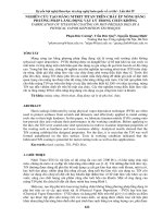
Figure 2.1 illustrates the principle of gravity exploration. On the left the surface
elevation is moderate but there is a thick sedimentary section overlaying the basement complex. At the center the surface elevation is near sea level and the subsurface
has a sedimentary section of normal thickness and density overlaying an “average”
basement complex. On the right the surface elevation is also moderate but there
is a thin sedimentary section resulting in the basement complex being close to the
surface.
The center part of Fig. 2.1 represents the “normal” earth situation and the suspended mass stretches the spring a “normal” amount here. On the left, the thick
Spring
Mass
Sedimentary Section
Basement Complex
Fig. 2.1 The gravity method