3 3 5 earth movement (earth science)
Bạn đang xem bản rút gọn của tài liệu. Xem và tải ngay bản đầy đủ của tài liệu tại đây (3.7 MB, 14 trang )
Suggested levels for Guided Reading, DRA,™
Lexile,® and Reading Recovery™ are provided
in the Pearson Scott Foresman Leveling Guide.
Genre
Expository
nonfiction
Comprehension
Skills and Strategy
• Compare and
Contrast
• Draw Conclusions
• Monitor and Fix Up
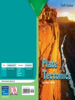
Earth Science
Earth
Mo vement
Text Features
•
•
•
•
Captions
Diagrams
Maps
Glossary
Scott Foresman Reading Street 3.3.5
ISBN 0-328-13366-3
ì<(sk$m)=bd g g< +^-Ä-U-Ä-U
by Carol Talley
Earth
Movement
Reader Response
1. Use a Venn diagram to compare and
contrast what you have learned about
predicting volcanic eruptions and
earthquakes.
volcanic
eruptions
earthquakes
2. Go back to page 9. Did you understand
what tiltmeters are and how they work?
Reread to clarify your understanding.
3. The word fault has other meanings
different from the one used in this book.
Use one other
in a complete
by meaning
Carol Talley
sentence.
4. Both page 16 and page 20 show images
of the San Andreas Fault. How did those
images help you understand the fault?
Editorial Offices: Glenview, Illinois • Parsippany, New Jersey • New York, New York
Sales Offices: Needham, Massachusetts • Duluth, Georgia • Glenview, Illinois
Coppell, Texas • Ontario, California • Mesa, Arizona
It is the day you have been waiting for, the
day of the canoe trip.The weather is going to
be perfect. Last night you heard the weather
forecaster on the radio say there would be clear
skies and plenty of sunshine. But now the sky is
getting dark.The air is getting cooler. Raindrops
are starting to fall.
It looks like the weather prediction was
wrong again!
Every effort has been made to secure permission and provide appropriate credit for
photographic material. The publisher deeply regrets any omission and pledges to
correct errors called to its attention in subsequent editions.
Unless otherwise acknowledged, all photographs are the property of Scott Foresman,
a division of Pearson Education.
Photo locators denoted as follows: Top (T), Center (C), Bottom (B), Left (L), Right (R),
Background (Bkgd)
Opener: ©DK Images; 1 ©DK Images; 3 Digital Vision; 5 ©DK Images; 7 ©DK Images;
8 ©DK Images; 11 ©DK Images; 13 Patricia Jordan/Peter Arnold, Inc.; 14 ©DK Images;
15 ©DK Images; 16 ©DK Images; 18 John K. Nakata/U.S. Geological Survey; 20 ©DK
Images; 21 ©DK Images; 22 ©DK Images
ISBN: 0-328-13366-3
Copyright © Pearson Education, Inc.
All Rights Reserved. Printed in the United States of America. This publication is
protected by Copyright, and permission should be obtained from the publisher
prior to any prohibited reproduction, storage in a retrieval system, or transmission
in any form by any means, electronic, mechanical, photocopying, recording, or
likewise. For information regarding permission(s), write to: Permissions Department,
Scott Foresman, 1900 East Lake Avenue, Glenview, Illinois 60025.
2 3 4 5 6 7 8 9 10 V0G1 14 13 12 11 10 09 08 07 06 05
eight-year old African-American
girl in pajamas is eagerly
listening to the radio.>
Same girl looking up into a
stormy sky.>
3
Predicting weather is not easy. After all,
nobody can really tell the future. Predictions
are smart guesses about what might happen.
They are built on things we have learned and
on our knowledge about how things work.
As difficult as it is to predict the weather,
scientists are discovering that it is even more
difficult to predict where and when volcanic
eruptions and earthquakes will happen. In fact,
sometimes it seems almost impossible! Still,
scientists keep working hard to learn more.
If scientists can discover warning signs that a
volcanic eruption or an earthquake is about to
happen, they can help protect our homes and
save our lives.
When will the volcano blow?
Volcanoes are erupting all the time. Some
scientists estimate that about ten of Earth’s
fifteen hundred volcanoes erupt every day!
Volcanologists have found many written
references to volcanic eruptions. Since the start
of recorded history people have written about
at least five hundred different
volcanic eruptions. Many
more volcanoes erupted
during prehistoric times,
before records were kept.
Scientists know that
some volcanoes that erupted
A loaf of bread
in the past are still active.
reduced to charcoal,
That means these volcanoes from the first century
A.D. eruption of
are likely to erupt again in
Mount Vesuvius
the future.
Mount Vesuvius today. The crater is evidence
of the mountain’s eruptions.
4
5
On land, volcanoes can often be seen from
miles away. When they erupt, some volcanoes
create enormous amounts of noise and can
damage everything around them.
A volcano may erupt and then sit quietly
for hundreds or thousands of years. Or it could
erupt twice or more in just a couple of years.
To learn how to spot the warning signs of an
eruption, scientists monitor many volcanoes.
Monitor means to keep a record, like a journal,
of all the changes that go on around a volcano,
day after day, year after year.
Volcano Monitoring
In 1847 the first volcano observatory was
created in Italy.The people who worked there
monitored Vesuvius, the volcano that destroyed
the city of Herculaneum in A.D. 79.
Modern volcano monitoring really began,
however, when scientists built the Hawaiian
Volcano Observatory on the rim of Kilauea.
Kilauea is one of the world’s most active
volcanoes.This observatory also sits near
the Mauna Loa volcano, which is almost as
active as Kilauea. Scientists at this observatory
have developed methods for monitoring
volcanoes that are now used
all over the world.
People watch smoke
and ash rise from the
crater of Mount Vesuvius
during an eruption in
the 1930s.
6
7
After many years of monitoring volcanoes,
scientists are becoming very skilled at spotting
the warning signs of an eruption.They have
learned that before an eruption, three things
usually happen.
By monitoring these events, scientists hope
to predict when a volcano eruption is coming.
Let’s look more closely at how this is done.
The three warning signs of a coming eruption
Certain kinds of gases are released.
Earthquakes
beneath
the volcano
increase.
8
Bulges and Tilts
When hot magma rises up inside a
volcano, the sides of the volcano may bulge, tilt,
or crack. Volcanologists use special instruments
that can measure and record these changes,
even if the changes are very small.
A tiltmeter is an instrument that measures
tiny changes in the slant of the ground.
Tiltmeters have been used to monitor the
shape of volcanoes for many years.Tiltmeters
are rather simple when compared to modern
equipment. But they are still very effective for
predicting eruptions. In 1980 a tiltmeter helped
scientists predict the eruption of Mount St.
Helens in Washington State.
The volcano
changes shape.
9
Today, instead of tiltmeters, volcanologists
rely mostly on satellites and the Global
Positioning System, or GPS, to measure
volcanoes.You might have ridden in a car with
a GPS system. GPS can be used to provide
directions for drivers. It can also be used to
monitor changes in a volcano’s shape.
Shakes and Quakes
An important part of monitoring a volcano
is to record the strength of these earthquakes
and where they happen inside the volcano.
To do this, volcanologists use seismometers.
Seismometers are instruments that measure
movements in the ground. Volcanologists
sometimes set up a network of seismometers
around a volcano.
It is common for small earthquakes to occur
beneath active volcanoes. Some volcanoes
send out weak vibrations all the
time. When magma and volcanic
gases force their way up inside a
volcano before an eruption, the
earthquakes usually increase in
strength and number.
Scientist inspecting seismometers
10
11
Escaping Gases
Progress Report
As magma rises inside a volcano, gases
escape from the top or from weak spots on the
sides. Scientists constantly check to see what
gases are released.They sometimes have to
go high up on the volcano to collect gases for
testing. While scientists are working on top of
a volcano, they are exposed to many dangers,
including poisonous fumes and the risk of a
sudden eruption.
Sometimes it is possible to put instruments
near the tops of volcanoes to collect and
measure gases automatically. Other times
volcanic gases can be measured from aboard
an aircraft or from a satellite.
There are now five volcano observatories
in the United States. Volcanoes are also being
monitored in Italy, Japan, New Zealand, and
Russia, as well as several other countries.
Scientists are not able to predict the exact time
and place of an eruption. Still, every year they
learn more about the warning signs that are
given off before an eruption.
Earthquakes seem to be even more difficult
to predict than volcanic eruptions. Some
scientists think it might be impossible for
humans to ever have success in predicting
earthquakes.
Kilauea Volcano, Hawaii
12
13
Predicting Unpredictable Earthquakes
The world has about eighteen major
earthquakes each year. Earthquakes can happen
anywhere. Most big earthquakes occur along
the edges of the Pacific Ocean, where several
of the huge plates that form Earth’s crust
meet.These plates are not like the ones you
eat dinner from! Instead, they contain mile
after mile of solid rock. When the plates rub
together, they can cause earthquakes.
As with volcanic eruptions, scientists know
a lot about where earthquakes are likely to
happen. So far scientists are not able to predict
when an actual earthquake is about to strike.
For many years,
earthquake scientists in
the United States studied
California’s San Andreas
Fault, which is formed
by the North American
and Pacific plates.The
scientists studying the San
Andreas Fault were hoping
A theodolite is used to detect to discover the signals that
changes in a volcano’s shape.
would warn when future
earthquakes were coming.
But earthquakes are not like volcanoes.
They do not seem to give off warning signals.
After many years of monitoring the San Andreas
Fault, scientists now know more about this
earthquake area than any other in the world.
But they have not successfully predicted the
exact time and place of a single earthquake.
Earthquakes usually happen along the plate
boundaries of Earth’s surface.
14
15
The Parkfield Earthquake Prediction
Experiment
Since 1857, six strong earthquakes have
struck the small town of Parkfield, California,
located on the San Andreas Fault. When the
next one strikes, scientists plan to be there!
Since 1985, the United States Geological Survey,
or USGS, has focused much of its earthquake
monitoring on this one location.
Monitoring an earthquake zone is a lot like
monitoring a volcano. Scientists at Parkfield
look for three of the same warning signals
that volcanologists monitor.They are watching
for changes in the shape of the land and the
release of certain gases.They also pay close
attention to earthquakes!
The San Andreas Fault, shown here in blue, runs
for hundreds of miles.
16
17
So, you might ask, how can an earthquake
serve as a warning that another earthquake
is on the way? The reason is that small
earthquakes, called foreshocks, sometimes
come before the main earthquake, called the
mainshock.There are seismometers in forty
places near Parkfield to measure every small
movement of the ground.
Scientists have also noticed that the
level of water in wells may change before
an earthquake. Wells are fed by groundwater.
Groundwater rises up from the spaces and
cracks in rocks deep in the ground. If there is
extra pressure on these rocks, the groundwater
might be pushed higher or deeper into the
rocks.This can cause the water level in wells
to go up or down. Scientists at Parkfield use
special instruments that measure any changes
in water level.
A geodimeter at the Parkfield
Earthquake Experiment emits
laser light while analyzing the
San Andreas Fault in California.
18
19
Still Waiting
In the 1980s, after studying the history of
earthquakes near Parkfield, scientists predicted
that a damaging earthquake would hit the
town between 1988 and 1992. Fortunately for
Parkfield, the prediction never came true. Still,
earthquake scientists in California continue
to monitor and collect important information
that may someday help them predict when an
earthquake will happen.
While they wait,
scientists and the
citizens of Parkfield are
also working together,
planning ways to keep
people safe when
an earthquake does
strike. Along with
town officials, disaster
assistance organizations,
and emergency service
workers, they are hoping
to save lives, homes,
and businesses by being
prepared.
The San Andreas Fault, the source
of past and future California earthquakes.
20
21
Now Try This
Earthquakes—Be Ready!
Millions of earthquakes happen around
the world every year. Earthquakes can
happen anywhere, at any time.
Earthquakes cannot be prevented, and
so far they cannot be reliably predicted.
The best thing to do is to be prepared. Help
your friends and family be prepared too!
Here is an activity for you to do with
your classmates that will help keep you
prepared for earthquakes.
A lightweight bag
of emergency items
for earthquake
survival
22
to Do It!
w
o
H
s
’
e
r
He
1. Gather information about how to
stay safe during an earthquake. Good
sources are the American Red Cross,
the Federal Emergency Management
Agency (FEMA), and the USGS.
2. Contact your local government.
Find out if your community has an
earthquake plan or advice about how
to be prepared.
3. Share your information with your
family. Have a family meeting and talk
about safe spots in each room of your
home. Practice what to do with your
family. Put together a home safety kit.
4. Help keep your friends at school safe
too. Make a poster about earthquake
safety for your school building. Share
the poster with your class. Explain what
an earthquake feels like and what to do
if an earthquake hits.
23
Glossary
fault n. a break in
Earth’s crust.
fumes n. unpleasant
or irritating,
sometimes
poisonous, gases.
instrument n. a
special tool.
magma n. melted
rock within Earth.
monitor v. to track
the changes or
developments of a
certain situation or
thing.
Reader Response
network n. a group
of connected things,
such as instruments,
machines, or
computers.
observatory n. a
place for watching
and studying
happenings in
nature.
1. Use a Venn diagram to compare and
contrast what you have learned about
predicting volcanic eruptions and
earthquakes.
volcanic
eruptions
earthquakes
prehistoric adj. from
the time before
written history.
volcanologists n.
scientists who study
volcanoes.
2. Go back to page 9. Did you understand
what tiltmeters are and how they work?
Reread to clarify your understanding.
3. The word fault has other meanings
different from the one used in this book.
Use one other meaning in a complete
sentence.
4. Both page 16 and page 20 show images
of the San Andreas Fault. How did those
images help you understand the fault?
24