Thermal imaging techniques to survey and monitor animals in the wild
Bạn đang xem bản rút gọn của tài liệu. Xem và tải ngay bản đầy đủ của tài liệu tại đây (14.25 MB, 361 trang )
Thermal Imaging
Techniques to Survey
and Monitor Animals
in the Wild
A Methodology
Kirk J Havens
Edward J Sharp
AMSTERDAM • BOSTON • HEIDELBERG • LONDON
NEW YORK • OXFORD • PARIS • SAN DIEGO
SAN FRANCISCO • SINGAPORE • SYDNEY • TOKYO
Academic Press is an imprint of Elsevier
Academic Press is an imprint of Elsevier
125, London Wall, EC2Y 5AS, UK
525 B Street, Suite 1800, San Diego, CA 92101-4495, USA
225 Wyman Street, Waltham, MA 02451, USA
The Boulevard, Langford Lane, Kidlington, Oxford OX5 1GB, UK
Copyright © 2016 Elsevier Inc. All rights reserved.
No part of this publication may be reproduced or transmitted in any form or by any means, electronic or mechanical, including photocopying, recording, or any information storage and retrieval
system, without permission in writing from the publisher. Details on how to seek permission, further
information about the Publisher’s permissions policies and our arrangements with organizations
such as the Copyright Clearance Center and the Copyright Licensing Agency, can be found at our
website: www.elsevier.com/permissions.
This book and the individual contributions contained in it are protected under copyright by the
Publisher (other than as may be noted herein).
Notices
Knowledge and best practice in this field are constantly changing. As new research and experience
broaden our understanding, changes in research methods, professional practices, or medical
treatment may become necessary.
Practitioners and researchers must always rely on their own experience and knowledge in evaluating
and using any information, methods, compounds, or experiments described herein. In using such
information or methods they should be mindful of their own safety and the safety of others, including
parties for whom they have a professional responsibility.
To the fullest extent of the law, neither the Publisher nor the authors, contributors, or editors, assume
any liability for any injury and/or damage to persons or property as a matter of products liability,
negligence or otherwise, or from any use or operation of any methods, products, instructions, or
ideas contained in the material herein.
ISBN: 978-0-12-803384-5
British Library Cataloguing-in-Publication Data
A catalogue record for this book is available from the British Library
Library of Congress Cataloging-in-Publication Data
A catalog record for this book is available from the Library of Congress
For information on all Academic Press publications
visit our website at />
Dedication
To my wife, Karla, who only occasionally raised an
eyebrow and rarely questioned the late night trips to “study
wildlife.” To my son, Kade, who understands the wisdom in
questioning everything and to my parents, Bill and Ginny,
who gave me the childhood freedom to explore.
Kirk J Havens
Preface
Over the past few decades there has been a marked increase in areas of remote
sensing, including thermal imaging, to study and count wildlife in their natural
surroundings. While much of the work with thermal imagers to date has been
devoted to testing equipment during surveys, little advancement has actually
been achieved. This is primarily due to three basic problems:
1. Early field studies were conducted with cryogenically cooled thermal imagers (photon detectors) with sensitivities an order of magnitude lower than
those available today. With few exceptions, the new and improved models
of thermal imagers with superior sensitivities and resolution have not been
used in the field because of the perceived difficulty in data acquisition and
to some extent limited availability and cost. The more recent fieldwork has
been for the most part confined to the use of uncooled bolometric cameras
that use thermal detectors as opposed to photon detectors.
2. A pervasive misunderstanding of what thermal imagers detect and record
and what ultimately constitutes ideal conditions for conducting thermal imaging observations.
3. The promulgation of results that have erroneously compared survey data
collected with thermal imaging equipment to that obtained with standard
techniques such as spotlighting or visual surveys.
In this volume, we spend considerable effort reviewing the literature and
pointing out fallacies that have been built upon as a result of these problems.
This book presents a methodology for maximizing the detectability of both vertebrates (homotherms and poikilotherms) and invertebrates during a census or
survey when using proper thermal imaging techniques. It also provides details
for optimizing the performance of thermal cameras under a wide variety of field
conditions. It is intended to guide field biologists in the creation of a window of
opportunity (a set of ideal conditions) for data gathering efforts. In fact, when
thermal imaging cameras are used properly, under ideal conditions, detectivity
approaching 100% can be achieved.
Recent attempts of researchers and field biologists to use thermal imagers
to survey, census, and monitor wildlife have in most cases met with limited
success and while there are a number of good books that treat the theory and
applications of remote sensing and thermal imaging in significant detail for
applications in land mapping, construction, manufacturing, building and vehicle inspections, surveillance, and medical procedures and analyses (Barrett
xi
xii Preface
and Curtis, 1992; Budzier and Gerlach, 2011; Burney et al., 1988; Holst, 2000;
Kaplan, 1999; Kozlowski and Kosonocky, 1995; Kruse et al., 1962; Vollmer
and Mollmann, 2010; Williams, 2009; Wolfe and Kruse, 1995), they contain
very little on how wildlife biologists should go about using this equipment in
the field to survey and monitor wildlife. This book provides detailed information on the theory and performance characteristics of thermal imaging cameras utilizing cooled quantum detectors as the sensitive element and also the
popular uncooled microbolometric imagers introduced into the camera market
in the past decades, which rely on thermal effects to generate an image. In
addition, there are numerous excellent texts devoted to survey design and statistical modeling to aid in the monitoring and determination of wildlife populations (Bookhout, 1996; Borchers et al., 2004; Buckland et al., 1993; Buckland
et al., 2001; Caughley, 1977; Conroy and Carroll, 2009; Garton et al., 2012;
Krebs, 1989; Pollock et al., 2004; Seber, 1982, 1986; Silvy, 2012; Thompson
et al., 1998; Thompson, 2004; Williams et al., 2001), but they do not include the
treatment of thermal imaging capabilities to help achieve these tasks. This book
is being offered as a bridge between the two technologies and the teachings
presented in these excellent volumes so that their combined strengths might be
united to improve upon past efforts to assess animal populations and to monitor
their behavior.
Even though there has been a technological disconnect since the earliest field
experiments, there has still been a considerable amount of work carried out by
biologists using thermal imagers to study and monitor wildlife. These studies began in the late 1960s and early 1970s when cryogenically cooled thermal imagers
using photon detectors were first used for surveys and field work (Croon et al.,
1968; Parker and Driscoll, 1972) and this phenomena continued to grow as thermal imagers became more readily available to field biologists. At the time, these
early cameras were acknowledged as being only marginally sensitive for the task
of aerial surveying. The more recent introduction of the low-cost uncooled bolometric cameras generated a new wave of experimentation with thermal imagers
in the field. The sensitivity and range of bolometric cameras are limited due to
the fact that they rely on a thermal process to generate an image. So we see at the
start that all thermal imagers are not the same and if they are used in the field they
must be used to exploit the strengths of the particular imaging camera so that
reliable data can be obtained. There are appropriate uses for imagers utilizing
photon detectors where high sensitivity and long ranges are characteristics making them suitable for surveying applications. There are also applications suitable
for imagers fitted with thermal detectors that have lower sensitivities and ranges.
Their advantages are their availability, cost, and that they are uncooled. Field
applications favoring bolometric cameras that do not require long ranges or high
sensitivity will also be addressed in this book.
The process of using thermal imagers as a tool to collect field data has been
compared with other data collection techniques; however, in nearly all cases the
thermal imager was not used correctly and perhaps was even inadequate for
Preface xiii
the task. This practice has led to a number of misconceptions about the basic use
of a thermal imager and the correct interpretation of the results. There is a big
distinction between thermal imagers that utilize quantum detectors as the sensitive element and detectors that rely on thermal effects to generate an image. The
differences are enormous as far as fieldwork goes for censusing and surveying,
particularly on a landscape scale. Unfortunately, a text describing the use of
3–5 and 8–12 mm photon detectors for animal surveys and field studies has
not emerged. This is probably due to the fact that 3–5 and 8–14 mm imagers
were not widely used since the first field experiments. These experiments used
cryogenically cooled units typically borrowed from military installations. These
robust units are now becoming available at a reasonable cost and should see increased use by field biologists. An excellent text describing the practical use of
pyroelectric and bolometric imagers for a wide range of applications has been
written (Vollmer and Mollmann, 2010) and a number of distinctions are pointed
out between these imagers and those using photon detectors as the focal plane.
Past work using thermal imagers in the field has mainly been carried out so
that comparisons could be made with other data gathering methods. From the
outset we see that comparing the results obtained with thermal imagers with that
of data collected with other methods such as spotlighting and visual surveys must
necessarily be skewed and these efforts, while commendable, do not allow for
a fair comparison of the data collection capability of the compared techniques.
Thermal cameras are suitable for surveys and counts throughout the 24-h diurnal
cycle while other methods are not. These studies by their nature and design mean
that the results of data collected with a thermal imager will be compared with
data collected using a method that was optimized for the conditions of the survey
at hand. For example, consider the comparison of data collected during a visual
survey and the data collected via thermal imagery using the same temporal and
spatial conditions. Note that the survey must be conducted during daylight hours
because the visual spotters need daylight to see the animals of interest. Thermal
cameras can also detect the animals of interest during daylight hours but there are
concomitant conditions required for the optimization of the thermal survey if it is
conducted during daylight hours. These conditions can be met in a relatively easy
manner but were not generally addressed during these past comparisons so the
results reported were skewed and in some cases grossly inaccurate. We review
many of these comparisons and offer alternatives. A variety of statistical methods, such as distance sampling and mark recapture, among others, were used for
estimating the abundance of animal populations in these comparisons and the
results of these studies were built upon by others. We do not treat these statistical methods here but point out that each of them has strengths and weaknesses
(Borchers et al., 2004), depending on the species of the animal being surveyed.
All will benefit from data collection methods that produce a detectability (see
Chapter 1) that approaches ∼100%.
The widespread dissemination of these results is the existing foundation that
later work has been built upon and it has led to a confusing and widespread
xiv Preface
misunderstanding of the capabilities of thermal imaging as a powerful survey
tool in these applications. This distribution of erroneous or badly skewed information regarding the performance of thermal imaging for these tasks needs
to be rectified and it is one of the major goals of this book to start that process.
The work of Romesburg (1981, p. 293) pointed out the fallacies of building
on unreliable knowledge: “Unreliable knowledge is the set of false ideas that are
mistaken for knowledge. If we let unreliable knowledge in, then others, accepting these false laws, will build new knowledge on a false foundation.” We still
overlook important aspects of the scientific inquiry to gain reliable scientific
knowledge. All the statistical methods applied to data gathered in the field are
better predictors when the count is completely random and the sample is large.
It is also known that the general methods used to count animals in the field during a survey are usually biased and yield animal counts less than what is actually
there; however, in some cases there will be more counted than are actually there.
These statistical losses or gains are presumably accounted for in the statistical formulation being used. The problems arise when the estimated parameters
to account for losses or gains in populations, along with other parameters to
account for such things as species mingling, group sizes, mortality rates, and
sometimes double counting, are folded into the calculations. Even though these
parameters are often very good guesses, they all come with systematic and
random errors attached and cannot predict valid outcomes except by chance
(Romesburg, 1981, p. 309). This is because the more parameters a model contains that are guesses the more they are amplified by their interaction with one
another through the calculations, such that the resulting errors can be quite large
at the output of the calculations.
It is essential for wildlife management and the preservation of healthy populations that we seek and promulgate reliable knowledge regarding the current
status of animals in the wild. Ratti and Garton (1996) advance the important realization put forth by Romesburg by showing that in order for wildlife research
to be useful to wildlife managers and their varied programs, it must be founded
on high-quality scientific investigations that are in turn based upon carefully
designed experiments and methodologies. Limitations to achieving the desired
high quality and reliable knowledge must be identified and rectified. We postulate that the single most important thing to do at the present time to mitigate the
unreliable knowledge stemming from skewed and distorted animal surveys and
counts is to look very carefully at the detectability possible by different counting methodologies.
The components of science required for meaningful and reliable outcomes
are mingled together in a relatively complex way. Wildlife managers and field
biologists must incorporate biology, chemistry, atmospheric science, physics,
and climatology, as well as the behavioral ecology and physiology of the animals
surveyed or studied. All must be considered when forming a research plan for a
species. The best window of opportunity for collecting data must be determined
based on the best science available. To this end, a detailed methodology for using
Preface xv
infrared thermal imaging to conduct animal surveys in the field and other studies requiring nondisruptive observation of wildlife in their natural surroundings
is developed in this book. We show that ∼100% detection can be achieved for
surveys if the methodology is formulated to take full advantage of the infrared
cameras used for observation and if it is coupled with the details of the behavioral ecology and physiology of the animals being surveyed or studied.
In this book we address the primary difficulty with surveying or censusing
animals and demonstrate that it is not the sampling methodology (i.e., distance
sampling, aerial transect sampling, quadrat sampling, etc.) or the statistical
model being used on the collected data, but rather lies with the detectability
that can be achieved with any particular sampling or data collecting technique.
This suggests that more work needs to be done on comparing factors that influence the detectability of a species of interest rather than the statistical methods
to compensate for the inadequacies of over or undercounting. There are many
other details of a research plan that could grossly skew or render the resulting
survey invalid (Thompson et al., 1998; Lancia et al., 1996; Krebs, 1989) but the
visual observation (or other counting methods) are well-known to be skewed
by a number of factors and limit data collection to daylight hours or when the
landscapes or transects are artificially illuminated. It is also known that artificial
illumination introduces behavioral modifications that can adversely influence
the detectability and introduce bias (Focardi et al., 2001). There are various
treatments proposed to deal with known biases. They are adjustments to the
calculations to deal with under- or overcounting animals during surveys resulting from biased detectability. In this work, we will concentrate on the task
of increasing detectability by eliminating bias in the data collection aspect of
wildlife monitoring.
Because thermal imaging can be conducted at any time during the diurnal
cycle and can be conducted from various aerial or ground-based viewing platforms, it offers a host of configurations to observe animals of interest while
using their preferred habitat. If performed correctly, the observations can be
conducted from a distance that precludes disturbances to the animals under
study, thus reducing the possibilities of skewing the counts or surveys caused
by anthropogenic-produced behavioral changes or double counting. Each variable introduced by some recognized uncertainty in the counting or observation
techniques used must be accounted for and if it is done statistically the results
become more and more questionable. If an uncertainty in the counting technique can be fixed at the field level, the resulting counts are closer in line with
the true situation because there is one less layer of data manipulation to perform
due to under- or overcounting.
As noted earlier, there is already a significant amount of up-to-date information available on methods for treating collections of field data with various
statistical formulations and appropriate assumptions. These mathematical tools
allow the evaluation of field data (if correctly collected) so that meaningful estimations of the abundance and/or the density of wildlife populations can be
xvi Preface
determined. As a result, we do not delve into these methods but rather focus on
the details of establishing a technique for correctly collecting data and achieving the highest detectability possible when conducting field work. Applications
other than those dealing with wildlife will not be treated here unless we need
to make a specific point about some aspect of the workings of a thermal imager
or if the application would clarify some aspect of the proposed methodology.
Applications such as military, surveillance, police work, fire detection, manufacturing, and building inspection have been well-treated by others and can be
found in the references mentioned earlier. The results of many studies of animal
behavior, thermoregulation, pathology, and physiology are also reviewed.
In order to appreciate the advantages that thermal imaging has to offer we
must recognize that our eyes are sensors that are limited in a number of ways
that limit their utility as effective detectors of wildlife in their preferred habitat.
Our eyes are confined to the visible region of the spectrum and at low-light levels they do not collect enough data so that our brain is able to form images that
are recognizable; however, there are a number of ways that we can easily extend
their functional range for our applications. For example, binoculars greatly enhance the probability of observing an object when faced with low-light levels
and long viewing ranges. If we can use various technologies and instrumentation to aid our vision by seeing in the dark and seeing at longer ranges, then we
need to add these things to our set of observational tools. In short we need to
detect objects in order to count them and we need to see them in some fashion
to detect them. The acquisition of images in the infrared region of the spectrum
can be provided by thermal imagers and as such serve as an aid to our overall visual capability. By utilizing thermal imagers we can create images of very high
contrast so that objects of interest are clear and distinct from their backgrounds,
allowing us to extend our visual capability into the dark portion of the diurnal
cycle. Once this is accomplished, the brain can process the images that the eyes
see. In fact, in recent work at Cal Tech and UCLA, researchers found that individual nerve cells fired when subjects were shown photos of well-known personalities. The same individual nerve cell would fire for many different photos
of the same personality and a different single nerve cell would fire for many different photos of another personality. Follow-up research suggests that relatively
few neurons are involved in representing any given person, place, or concept,
which makes the brain extremely efficient at storing and recalling information
after receiving visual stimulation.
Without going into a detailed mathematical description of thermal imaging
and the complex principles behind the operation of thermal imagers (thermal
cameras) we instead introduce basic laws and principles that allow us to set the
stage for data collection with thermal imagers. However, field biologists need
to have a basic understanding of the physics governing heat transfer processes
in the environment (Monteith and Unsworth, 2008) and the effects of local meteorological changes on the performance of a thermal imager. The proper use of
a thermal imager requires a basic knowledge of how an imager works, why we
Preface xvii
see what we see with a thermal imager, and how we can optimize those images
for the tasks at hand. Simple “point-and-shoot” infrared imagery for data collection will not work nor will using someone else’s “point-and-shoot” imagery
in sophisticated statistical calculations. What the imagery actually represents
and how it was acquired must be known for it to be useful. While the performance capability of uncooled thermal imagers has improved remarkably over
the last decade and the cost of these cameras has become reasonable for most
researchers, field biologists must understand how they work, how to use them,
and what they are actually recording as imagery. Unfortunately, for the most
part, the rapid technological advancement and availability of thermal imagers
has outpaced the knowledge and understanding required of the specialists using
them in the field (Vollmer and Mollmann, 2010, p. xv). This sad commentary
regarding the use of thermal imagers stems, for the most part, from applications
associated with monitoring inanimate objects in fixed backgrounds. Our applications, as we have already pointed out, are much more difficult and complex
so we need to be particularly careful and thorough in our understanding of a few
basic principles regarding thermal imaging and wildlife ecology.
This book is about formulating a methodology to optimize a window of
opportunity so that wildlife can be observed and studied in its natural habitat.
This requires that biologists and program managers get together and formulate
a sound survey design, which assumes that they know the ecology of the species of interest plus all mitigating factors that could possibly distort the outcome
of a thermal imaging survey. The methodology presented here is logical and
simple yet it demands a detailed understanding and incorporation of critically
interlinked disciplines arising from biology, physics, micrometeorology, animal physiology, and common sense. Thermal imaging is a technique that forms
images from heat radiating from objects and their backgrounds, so much of
the information contained in this book is devoted to managing the interplay
of the heat transfer processes of conduction, convection, and radiation between
the objects of interest (animals) and their backgrounds to obtain the best thermal
images. We will see that creating this window of opportunity is not as restrictive
as one might think. Data can be collected from ground- or aerial-based platforms at any time during the diurnal cycle without compromising detectivity,
disturbing the animals, or altering their behavior. Even though the methodology
used to obtain meaningful data brings together a wide range of criterion and requirements that must be met concomitantly, it boils down to creating a window
of opportunity that will allow researchers to conduct surveys with near 100%
detectability by properly using thermal imagers as a detection tool.
About the Authors
Kirk J. Havens was born in Vienna, Virginia and received his BS in Biology
(1981) and MS in Oceanography (1987) from Old Dominion University and a
PhD in Environmental Science and Public Policy (1996) from George Mason
University.
He is a Research Associate Professor, Director of the Coastal Watersheds
Program, and Asst. Director of the Center for Coastal Resources Management
at the Virginia Institute of Marine Science. He also serves as a collaborating
partner at the College of William & Mary School of Law, Virginia Coastal
Policy Clinic. His research has spanned topics as diverse as hormonal activity
in blue crabs to tracking black bears and panthers using helicopters and thermal imaging equipment. His present work involves coastal wetlands ecology,
microplastics, marine debris, derelict fishing gear, and adaptive management
processes. He hosts the VIMS event “A Healthy Bay for Healthy Kids: Cooking
with the First Lady” and the public service program “Chesapeake Bay Watch
with Dr Kirk Havens”.
He is Chair of the Chesapeake Bay Partnership’s Scientific and Technical
Advisory Committee. He was originally appointed to STAC by Gov. Warner
and was reappointed by Gov. Kaine, Gov. McDonnell, and Gov. McAuliffe.
He was also appointed by North Carolina Gov. Perdue to serve on the Executive Policy Board for the North Carolina Albemarle-Pamlico National Estuary
Partnership and is presently vice-chair. He serves on the Board of Directors
and is past Board Chair of the nonprofit American Canoe Association, the Nation’s largest and oldest (est. 1880) organization dedicated to paddlesports with
40,000 members in every state and 38 countries.
xix
xx About the Authors
Edward J. Sharp was born in Uniontown, Pennsylvania, attended Wheeling
College and John Carroll University and received PhD degree from Texas A&M
University in 1966. He conducted basic research in the area of applied nonlinear
optics at the US Army Night Vision & Electro-Optics Laboratory and the US
Army Research Laboratory. Presently, he is working as a consultant on the use
of infrared imaging equipment in novel application areas. His major areas of
interest include laser crystal physics, thermal imaging materials and devices,
electro-optic and nonlinear-optical processes in organic materials, beam-control
devices, optical solitons, harmonic generation, optical processing, holographic
storage, photorefractive effects in ferroelectric materials, and the study of animal ecology using thermal imaging equipment. He is the author or coauthor of
more than 100 technical publications and holds over 15 patents on optical materials and devices. He is a member of the American Optical Society. Recently,
he has been working on new methods for using thermal imaging to address
issues related to animal ecology and natural resource studies with faculty at the
Virginia Institute of Marine Science (VIMS), College of William & Mary.
Acknowledgments
A special thanks to the following people and organizations: David Stanhope
and Kory Angstadt, Virginia Institute of Marine Science/Center for Coastal Resources Management/Coastal Watersheds Program; Bryan Watts, College of
William & Mary; Richard Pace, Louisiana State University; Deborah Jansen,
US Fish & Wildlife/Big Cypress National Reserve; Kenny Miller, US Army
Night Vision & Electronic Sensors Directorate; Greg Guirard, US Fish & Wildlife Service; US Fish & Wildlife Great Dismal Swamp Refuge, Virginia Living
Museum, Peninsula SPCA, Newport News, VA; and Carl Hershner, Virginia
Institute of Marine Science/Center for Coastal Resources Management.
xxi
Chapter 1
Introduction
Finding, monitoring, and accurately counting animals in the wild are very complex tasks that have been attempted in a variety of ways and with varying degrees of success. The sheer volume of literature devoted to this topic is staggering and the activity devoted to these tasks is becoming increasingly more
important as suitable wildlife habitats shrink due to the ever-increasing demands
of humanity. There are new conflicts arising on a daily basis between potential
user groups for these lands in urban, rural, and wilderness areas. The recreational, energy, farming, livestock, manufacturing, timber, mining, petroleum,
housing, and transportation industries, among others, all make arguments for the
best use of these resources. While each group argues for the best management of
these resources based on their own perception of value, they do so for the most
part lacking accurate counts of the living resources indigenous to these areas.
In the absence of verifiable scientific information on the population status
and trends in specific regions and in some cases for specific animals listed under
the Endangered Species Act, the resource management issues can be significant.
Areas such as game lands, military installations, national forests, and parklands
are facing pressures in the form of restrictions or lack thereof, because management decisions are being made based on incomplete or inaccurate field data.
These uninformed decisions can be very costly, because unwarranted restrictions placed on the use or development of land for recreation, power production,
timber, oil, etc. represents a clear loss of revenue. Likewise, the improper use
of a critical habitat places the living resources in the affected area at risk and in
some cases threatens them with extinction.
A variety of techniques can be used effectively to manage and recover endangered species; some are identical to techniques used with more abundant
species, but many others are specially adapted to the needs of rare species. Special approaches are needed because it is uncommon for most endangered species to have had their habitat requirements defined specifically enough to guide
a recovery effort (Scott et al., 1996). The management of endangered species
is complicated by their rarity, by legal restrictions intended to protect such species, and by the public and political scrutiny under which endangered species
management is conducted.
Lands that have already been set aside and established for particular uses
would also benefit from accurate counts, particularly if the animals concerned
are listed as threatened or endangered under the Endangered Species Act. For
Thermal Imaging Techniques to Survey and Monitor Animals in the Wild: A Methodology
/>Copyright © 2016 Elsevier Inc. All rights reserved.
1
2
Thermal Imaging Techniques to Survey and Monitor Animals in the Wild
example, it has been noted that the determination of the population status and
trends of threatened or endangered species on Department of Defense (DOD)
installations are inadequate. As a result, the US Fish and Wildlife Service has
developed management practices for these installations that place restrictions on
training activities for certain periods of time during the year and on certain areas
of the DOD land. Detection and identification of animals on these lands are essential in determining whether these activities can go forward. The Endangered
Species Act of 1973 calls for a rare, threatened, or endangered determination
and the resulting protective measures that the law provides if the number of
individuals within a species is reduced to dangerously low levels, such that the
extinction of the species is a real probability. These issues point to the need for
simple, accurate, and inexpensive monitoring and survey techniques that can be
conducted on the ground or from the air for a variety of habitats.
If field data is timely and accurate, a comprehensive management plan
might be formulated that only periodically mandates restrictions or permits
certain activities within the boundaries of contested lands. These restrictions
and/or special uses may be implemented periodically or only implemented on
portions of the land that are deemed suitable based on accurate field data. Most
animal surveys are done to aid wildlife managers, particularly managers of public game lands. For example, decisions to control herd size either by increased
or decreased harvesting are frequently based on inaccurate or outdated animal
counts. The increased demand for the habitat that remains available to game
animals has raised the need for population information to a new level. Since the
regions of habitat are often fragmented and connected only by narrow corridors
the survey information must be of a spatial or temporal nature or both. That is,
in many cases the managers need to know how many animals there are, where
they are located, and when they are there.
Decisions are made every day about how best to maintain the health and
stability of wild animal populations. These decisions are influenced by a number of factors, many of which are the result of anthropogenic-induced changes,
whether intentional or not. Such changes may include habitat loss, habitat modification through pollution (light, toxics, noise, etc.), and habitat fragmentation.
These changes can lead to highly skewed redistributions and/or population loss
or, in some cases, such as white-tail deer, to unsustainable population gains due
to a lack of predators and/or hunting. Even so, there are decisions made that can
further exacerbate existing problems. In many cases management decisions to
alter the population density or distribution of wildlife are determined by economics or politics.
Chadwick (2013) pointed out in a news release that cougars (Puma concolor)
are now the most common apex predator across one-third of the lower 48 states
and that most of the other two-thirds lack any big predatory mammals. Even so,
since predation by cougars was deemed responsible for a reduced deer population in South Dakota, hunting permits were issued for 100 cougars out of a total
population estimate of 300 even though the decline of elk and deer in South
Dakota was actually due mainly to excessive sport hunting. It is ironic that this
Introduction Chapter | 1
3
planned change to reduce the total population of cougars by a third came about
because hunters complained to state game commissioners that “there’s no game
left in the woods.” To put this in perspective, consider that the hunters of South
Dakota can now shoot cougars so that the deer and elk populations can increase
and they too can be hunted. Chadwick (2013) further points out that in Texas,
cougars are classified as varmints; you can shoot one almost anywhere at any
time. California, on the other hand, has not allowed cougar hunting since 1972
and now has the most cougars of any state. It also has an abundance of deer and
one of the lowest rates of cougar conflicts with humans. On the flip side, there
are cases where deer numbers are deemed to be too large and sharpshooters are
called in to reduce herd size, thereby reducing auto/deer collisions in suburban environments. This emphasizes the need for accurate data for all species
involved in a management decision to alter existing population densities for
whatever reason.
As mentioned earlier, determining a wildlife population density is not an
easy task. To get an idea of the difficulty first consider an animal population
that is not wild and is merely spread over twenty acres. The farmer who has
twenty cows in a rolling pasture of 20 acres can guess that at any given time
he has a population density of 1 cow/acre, but he would have to check to make
absolutely sure. He can do a survey or census, which can be done in a number
of relatively easy ways. Some choices might be walking the perimeter of his
pasture and noting the location and number of cows or he might drive the old
pickup truck along the fence line (it is a fenced and closed population at the
moment). Note that this might be easy or very difficult since the one or two
cows that are not accounted for may be unobservable from the truck or on foot
because of the features of the terrain, unless he gets very close to them. He may
have to walk or drive the pasture several times to locate all of his cows with certainty. On the other hand, if each of his cows is identifiable with a tag, he could
wait at the watering trough and count them as they come to drink. However, if
one cow is not thirsty then he has to take a hike in his 20-acre pasture to find
the missing cow. Another (albeit far-fetched) option might be to take video of
his pasture with a thermal imager and record the animals within the fenced area.
This video session could be carried out during the day or night, whichever is
convenient for the farmer. Figure 1.1 is provided as a sample of what the thermal imagery might look like for his herd of cows and provides a record for the
farmer for future comparisons. Each of the above methods requires effort, takes
time, and costs money, but when the farmer is finished with his census he knows
how many cows are in his pasture. Based on this information he can make good
decisions that are important to him and the health of his cows.
When biologists go into the field to conduct a “survey” or “census” of some
animal population (the animals that occupy a particular area at a particular time)
the objective is to count all the animals of interest in the immediate area of
observation. Simply put, all animals of interest should be detected. Note that a
“census” is designed to count all the animals or the complete population so only
special cases and relatively small sections of the habitat can be included in the
4
Thermal Imaging Techniques to Survey and Monitor Animals in the Wild
FIGURE 1.1 A thermal image of a small herd of cows including adults and calves. It is a
single frame extracted from a video that was taken in daylight hours under partly sunny skies.
count. Generally, a census of animals in the wild is not undertaken because of
the difficulty with geographic closure. Some examples of where a census might
be appropriate could be an island, a section of fenced range, a roosting site for
birds, or an ice flow for walrus. If the condition of geographic closure is met
and there are no animals moving into (immigration) or out of (emigration) the
census area then we will obtain the population of the island, section of fenced
range, bird roost, or ice flow. A “survey” on the other hand does not require a
complete count of all the animals but only the animals included in the field of
view when sampling the animals’ habitat. This allows surveys to be taken on
a much larger scale to include landscapes such as range lands, deserts, vast
expanses of open water, and game lands. A robust population estimate can be
made if the survey techniques provide high detectability of the animals of interest within the field-of-view.
The objective of this work is to develop a methodology for the use of thermal imaging techniques in the inventorying and monitoring of a broad range
of animals (both homothermic and poikilothermic), including threatened and
endangered species. These sampling methodologies can be applied at the landscape scale and are applicable to multiple species. Chapter 2 provides a brief review of population surveys using visual and photographic counting techniques.
Chapter 3 covers remote sensing techniques as a tool for counting and monitoring wildlife where the use and the benefits of trip cameras, video recorders,
image intensifiers or night vision devices, and radars are reviewed.
The multitude of problems associated with achieving high detection rates in
past animal surveys will be examined and a new formulation of techniques for
using infrared thermal imaging systems to overcome these problems will be covered in the remaining chapters. Chapter 4 covers the heat transfer processes of
conduction, convection, and phase changes. Chapter 5 is devoted to the radiation
Introduction Chapter | 1
5
heat transfer process, which is the basic underlying process responsible for the
formation of thermal images. Chapter 6 reviews the emissivity (number ranging
from 0 to 1), a ratio that compares the radiating capability of a surface to that of
an ideal radiator or “black body” and which depends on a wide range of physical
conditions. These chapters provide the details necessary for understanding the
physical phenomena that can affect thermal radiation and subsequently influ
ence the quality of imagery that can be formed by a thermal imager.
The current status and availability of thermal imagers, including detailed
information on the theory and performance characteristics for cameras utilizing
cooled quantum detectors as the sensitive element or uncooled micro bolometric imagers, is covered in Chapter 7. Suggestions are included for the selection
of a thermal imaging camera to meet specific applications based on range, sensitivity, resolution, camera availability, and cost. A review of the latest infrared
imaging equipment available and its use provides a foundation for those seeking
to use the thermal imaging technique for wildlife field studies.
Much like the farmer and his cows, wildlife managers would like to know
the animal abundance and/or the population density of the species for which
they are responsible. They may also want to determine the sex of individual
animals or determine the ratio of adult to juvenile animals within a particular
species. To do this they only need to completely count (as did the farmer) all the
animals of interest on the landscape of interest. The magnitude of this challenge is
truly daunting. The problem of 20 cows confined to a fenced 20-acre pasture has
mutated into a much more complex problem. We now need to determine an
unknown number of animals of interest that are mixed with several other species of animals of similar size and ecology. The fenced pasture is replaced with
a vast landscape of variable terrain and vegetation ranging from bare ground to
heavily forested. On this landscape the animals of interest are in a constant state
of change both in number (reproduction and death) and location (immigration
and emigration) as they seek food and shelter. A census would be impractical;
however, we can conduct properly designed surveys that are well planned and
executed to determine the number of animals in the area of interest (which can
be of varying size, depending on the present interest of the survey). If we can repeatedly detect all target species that are being surveyed at a particular location
and time with ∼100% detectability, then we can determine an accurate population density for the landscape. The key point here is detectability.
Throughout this book we try to use terminology which is considered common
(Krebs, 1989; Lancia et al., 1996; Pierce et al., 2012; Thompson et al., 1998) in
the studies and surveys of wildlife. There are a few terms that we want to define
for the sake of clarity.
Detectability: The probability of correctly noting the presence of an animal of interest within some specified area and period of time (Thompson
et al., 1998). This definition has been advanced by a number of authors and
we shall use it here.
6
Thermal Imaging Techniques to Survey and Monitor Animals in the Wild
Sightability: The probability that an animal within the field-of-search will be
seen by an observer.
Observability: The probability of observing (seeing or catching) an animal
within the field-of-search.
We note that these definitions are similar and have been used interchangeably in the literature. The definitions of sightability and observability are essentially the same (seeing an animal in the field-of search). Since these are not as
specific as detectability (seeing an animal of interest within the field-of-search)
we elect to use the term detectability in this book.
The techniques provided in this work are capable of being applied at the
landscape scale in order to supply inventory and provide monitoring of animals
that will produce population levels and demographic data, in addition to confirming species’ presence or absence. Both ground-based and aerial-based applications of thermal imaging are presented. The use of thermal imaging significantly improves estimates of animal populations and overcomes the problems
that render other techniques inadequate during the detection phase of the surveys. These improvements are sought because typical aerial surveys conducted
of animals in a forested habitat or partially forested habitats are strongly skewed
as a result of visibility bias. That is, animals are very difficult to detect in their
natural habitat with the naked eye due to the fact that quite often the coloration
of the animal and its background are very similar. Compounding this obvious
camouflage problem is the fact that the amount of skewing is affected by a host
of factors such as aircraft speed, altitude, weather conditions, spotter experience
(also including fatigue and distractions), animal group size, vehicle access, time
of day, and ground cover, among others. It is essential that a method of surveying animal populations be developed that is capable of completely eliminating
visibility bias and allows for maximum detectability. Once an adequate survey
design has been established this is the first step toward obtaining accurate animal surveys, regardless of the statistical technique used to determine the animal
abundance. It allows accurate population estimates to be determined from any
number of statistical models (Seber, 1982, 1986; Buckland et al., 1993, 2001;
Lancia et al., 1996; Thompson et al., 1998; Borchers et al., 2004; Conroy
and Carroll, 2009) and coupled with other parameters, such as birth-death
rates and harvesting numbers, should be adequate to determine populations at
a given point in time precluding any abnormal losses due to extreme weather
conditions or disease.
Counting and monitoring animals in their natural environment is difficult
because of the conflicting requirements of finding out as much as possible about
the demographics of the population while leaving it undisturbed. Specifically, the
lack of control over natural populations coupled with the possibility of nocturnal and reclusive behavior, large group sizes, inaccessible habitats, visibility
bias, and comingling of species makes counting animals in the wild a daunting task. Another significant problem involves the monitoring and counting of
Introduction Chapter | 1
7
reintroduced species. Their numbers could be small and they may be widely
dispersed and comingled with species of similar size, so finding these animals
in the wild would be difficult without radio telemetry or other signaling devices
placed on the animals at their release (Havens and Sharp, 1998). However, once
the general location of such individuals or groups is established, the monitoring of their activities would be straightforward using thermal imaging methods.
Thermal imaging technology developed by the military has recently found its
way into the commercial market place. For example, thermal imaging systems,
both handheld and airborne units, are now available with sensitivities more than
an order-of-magnitude better than the units used in the early experiments devoted to large mammal surveys (Croon et al., 1968; Parker and Driscoll, 1972).
With these improved thermal cameras one can easily detect all faunae that radiate energy as a part of their basic metabolic function (i.e., homotherms) and
insects that collectively generate heat within the hive or nesting cavity. The
present work will provide the field researcher with the techniques and methodology to locate and identify individual animals or distributions of animals
(homotherms and poikilotherms) in their natural habitats. Present methods for
inventorying and surveying most species (particularly animals with extended
home ranges) such as spotlight counts, mark to recapture, and aerial surveys
introduce behavioral variables and viewer bias (LeResche and Rausch, 1974;
McCullough et al., 1994). Thermal imaging technology provides a method for
obtaining counts of animals with little risk of behavioral or sampling bias. The
basic performance parameters and important system considerations for thermal
imagers are covered in Chapter 8.
Three levels of information can be extracted from the thermal imagery collected: detection (observation and number of warm objects contained in the
thermal image), recognition (a determination if the detected objects in the thermal scene are biotic objects of interest), and identification (what species have
been detected). It is important to note that these three levels of information are
assumed to be contained within the detectability but in fact refer to completely
different levels of knowledge regarding the thermal signatures extracted from
the imagery. In prior work we demonstrated that thermal imagery could identify
individuals within a species (Havens and Sharp, 1998). Radio-collared panthers
(Puma concolor coryi) could be distinguished from noncollared panthers from
the air due to the unique thermal signature of the collar (cool band across the
neck). In many cases it is only necessary to achieve detection with the thermal
imagery collected. For bats and birds one needs only the detection phase for accurate and complete counts. For herding animals one may only need detection
capability when the species location is known but numbers are not. In other
situations, where more than one species of similar size, shape, and numbers
may occupy the same habitat, it may be necessary to achieve identification for
accurate surveys.
In Chapter 10 we review many past efforts to find, monitor, and count animals in the wild. We also review the results of thermal imaging experiments for
8
Thermal Imaging Techniques to Survey and Monitor Animals in the Wild
monitoring and counting wildlife as described in the literature. Most of these
efforts were attempts to compare thermal imaging techniques with some other
methodology for surveying or estimating animal abundance. In almost every
case thermal imaging proved to be superior even though the use of the thermal
imagers was not optimized. Remarkably, in some cases researchers refused to
accept the results of their own work that showed better performance using thermal imaging to improve detectability. These works include the use of aerial
and ground-based platforms to monitor both vertebrates and invertebrates in
terrestrial, aquatic, and air environments. The strengths and weaknesses of the
techniques used in those efforts are examined and suggestions are offered for
improvement through the use of remote thermal imaging as a technique. We
look critically at the past work done during field studies such as surveys and
counts as well as experiments that compared the detectability obtained with
thermal imaging with other techniques. We illustrate that using a thermal imager correctly is more important than having the most expensive imager.
What exactly is a thermal image and what does one look like? All objects
radiate heat and the amount of heat radiated is determined by the condition of
the object’s surface and by its temperature. Modern thermal imaging cameras
are capable of measuring the heat radiating from objects. Since heat transfer by
radiation occurs at the speed of light, images of the objects can be formed. One
can record thermal images captured by the infrared (IR) camera on video, view
the camera display on a monitor, or simply view the objects of interest through
a viewfinder as one could with a conventional camcorder. The only difference
is that the IR camera senses and displays a spatial distribution of thermal (heat)
energy instead of visible light. This allows one to see in total darkness, through
smoke, and other low visibility, low contrast situations. These cameras can also
be used during daylight hours to see heat generated images when visual observation is inadequate to distinguish a heat emitting object from its background.
The imager detects the infrared energy given off by all objects in a particular
scene. Since thermal imaging is a technique to form images from heat radiated from objects and their background, much of the information contained in
this book is devoted to managing the interplay of the heat transfer processes
of conduction, convection, and radiation between the object of interest and its
background to obtain the best thermal images possible for a wide range of uses.
Chapters 4, 5, and 6 are devoted to a discussion of this interplay and how it can
affect the formation and usefulness of thermal images. The details of the properties of a thermal signature (a particular image within a scene) and a discussion
of image interpretation are contained in Chapter 9.
As we mentioned earlier, the texts currently available that describe the use
of remote sensing, including texts devoted to applications utilizing thermal
imagers, do not address the problems associated with monitoring and/or conducting animal surveys. The books devoted to animal counting and surveys
do not properly treat the use of thermal imaging to carry out these tasks. Of
those listed above the book by Barrett and Curtis (1992, p. 58) is perhaps the
Introduction Chapter | 1
9
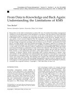
FIGURE 1.2 Infrared line-scan imagery of land near Mark Yeo, Somerset, UK. (Courtesy:
Barrett and Curtis, 1992; with kind permission of Springer Science + Business Media)
most informative regarding the quality of infrared images taken from aircraft.
Without having a great deal of understanding about thermal imagers and their
capabilities, we are still able to look at the photo presented in their book of a
thermal image taken from an aircraft of the rural countryside in England and get
a good understanding of the strength that thermal imaging can bring to census
and survey work.
The image depicted of the countryside in Somerset, UK (Figure 1.2) was
captured with an older model line scanning imager and it shows hundreds of individual farm animals dispersed over a landscape of considerable extent, yet the
high contrast imagery leaves the individual animals easily detected and countable. The imager used has a relatively wide field-of-view and, if a fixed portion
of this field-of-view were used to survey transects across this landscape, the
detectability of these animals could be ∼100% with very little deviation. When
examining this single photo, keep in mind that this imagery is typically recorded
as a video that can be studied frame by frame and can be enhanced to examine
particular features of interest. There may be a small percentage of the animals
lost in the lee of the hedgerows when comparing the thermal signatures of the
animals with their backgrounds (the surface soil that has not been cooled by
the prevailing wind through evaporation or convection). This possible source
10
Thermal Imaging Techniques to Survey and Monitor Animals in the Wild
of divergence from perfect detectability could easily be rectified at the field
level in a number of ways using an appropriate methodology. The concepts and
the effects of heat conduction, convection, and phase changes are covered in
Chapter 4.
The results of many studies of animal behavior, thermoregulation, pathology,
and physiology are also reviewed. A brief review of thermographic applications
in studies of wild animals that included disease diagnosis, thermoregulation,
control of reproductive processes, analyses of animal behavior, and detection
of animals and estimation of population size was carried out by Cilulko et al.
(2013). These studies were conducted with thermal imagers based on thermal
detectors such as microbolometers as opposed to photon or quantum detectors
typically used for surveys and censusing applications. The main difference between these two types of imagers is discussed in Chapter 7 and their properties
and limitations are described.
In Chapter 11 we devote sections to each of the important aspects of an
appropriate thermal imaging methodology and its function in the overall convergence of critical information and requirements to create a window of opportunity for data collection. This book is about optimizing that window
of opportunity to observe wildlife in its natural habitat. The methodology is
logical and simple yet it demands a detailed understanding and incorporation
of critically interlinked disciplines arising from biology, physics, meteorology,
animal physiology, and common sense. The techniques of remote sensing with
a thermal imager and the progression from the detection of thermal signatures to
the recognition and identification of species are described. We discuss the multitude of problems associated with achieving high detection rates in past animal
surveys and present a new formulation of techniques for using infrared thermal
imaging systems to overcome these problems and make it possible to achieve
∼100% detectability in the field. The techniques forming the basis of the procedural methodology can be used for ground and aerial-based surveys as well as
behavioral studies in the field and are not confined to low-light level situations
and, when used during daylight hours, eliminate the problems associated with
visibility bias. We conclude with Chapter 12, a short discourse on the latest
technological developments directed at miniaturizing thermal imaging cameras
and the prospects of flying these cameras with remote piloted vehicles (drones).
Chapter 2
Background
Chapter Outline
Overview and Basic Concepts
Counting Methods
11
14
Direct Counting Methods
Indirect Counting Methods
14
31
OVERVIEW AND BASIC CONCEPTS
A fundamental requirement for the proper management, protection, or preservation of any animal species is an accurate determination of its estimated
population. To find and count animals in the wild is a very complex task that has
been attempted in a variety of ways and with varying degrees of success. The
sheer volume of literature devoted to the topic of estimating animal populations
is staggering and the activity devoted to these tasks is becoming increasingly
more important as suitable wildlife habitats shrink due to the ever-increasing
demands of humanity. Accuracy in accomplishing these tasks is of the utmost
importance since the information acquired can be used in decision making to
help solve problems regarding the welfare of the animals in the estimated population. This information can also aid in resolving problems perceived by the
public, such as over/under harvesting of game animals, losses of habitats due
to urbanization, or perhaps public concerns of a suspected wildlife population
decrease due to man-made pollutants.
The interest in population dynamics (Johnson, 1996) is becoming a subject
of increasing importance as the demand for limited habitats by competing species grows. Information regarding the relationships among species, subspecies,
and populations is essential for making informed and timely decisions needed
to maintain sound wildlife management practices. A broad but useful definition
of population is a group of organisms of the same species living in a particular
space at a particular time (Krebs, 1985). In most cases a species is made up of
many populations, and a population is only one segment of a species. The exception to this is perhaps a species that is faced with extinction, which is a situation
that is becoming more common. Ratti and Garton (1996) point out that the wildlife scientific community usually deals with three types of populations: the
biological population, the political population, and the research population.
The biological population is an aggregation of individuals of the same species
Thermal Imaging Techniques to Survey and Monitor Animals in the Wild: A Methodology
/>Copyright © 2016 Elsevier Inc. All rights reserved.
11
12
Thermal Imaging Techniques to Survey and Monitor Animals in the Wild
that occupies a specific locality, and often the boundaries can be described with
accuracy. The political population has artificial constraints of political boundaries, often dictated by city, county, state, and federal or international jurisdictions.
The research population is usually only a portion or segment of the biological
population and it is this segment that is sampled to obtain information regarding
the relationships among species, subspecies, and populations.
The quality of an estimate is determined by its accuracy, precision, and bias
and their relationship to one another and is usually discussed in conjunction
with an illustrated target diagram proposed by Overton and Davis (1969); see
also Ratti and Garton (1996), Lancia et al. (1996), Conroy and Carroll (2009),
and Pierce et al. (2012).
An accurate estimate is one that is both unbiased and precise. It is determined by the average of the squared deviations between the true population size
and the population estimate repeated many times.
The precision of an estimate depends mainly on the size of the sample and
the closeness of repeated measurements to one another. The difference between the repeated measurements is call the variation and it can be broken out
into temporal, spatial, and sampling variations. The temporal and spatial variations refer to changes in the number or distribution of the target species over
time and space within the sampling area, which is pretty much in a state of
constant flux due to the availability and abundance of food, seasonal changes,
predation, weather, fires, and perhaps the presence of humans. The sampling
variations can be further divided into two components: one consisting of variation in counts between sampling plots dispersed according to a selected survey
design across the particular landscape of interest and the other variation coming
from incomplete counts or surveys within individual plots. Siniff and Skoog
(1964) conducted an aerial survey for caribou (Rangifer tarandus) in central
Alaska using sampling plots (quadrats) of 4 square miles. Their entire study
area was comprised of six strata based on a pilot study of caribou densities in
different regions. The 699 quadrats were divided unequally among the six strata
(18 in the smallest and 400 in the largest). The idea here is to pick strata to be
as homogenous as possible so that the precision can be improved. If one were
able to divide a highly variable population into homogeneous strata such that all
measurements within a stratum were equal, the variance of the stratified mean
would be zero or there would be no error. There are therefore advantages for
using stratified random sampling.
The bias of an estimate defines how far the average value of the estimate is
from the true wildlife population. Ratti and Garton (1996) point out that evaluat
ing bias in an estimate is difficult and usually has been done in the past on the
basis of the researcher’s biological knowledge and intuition. Bias can occur,
for example, at the sample plot level from poor placement of plots within the
sampling area such that there may be plots that overlap or share borders (leading
to double counting). Bias can and frequently does occur at the counting level
where two types of errors are possible. If an animal is misidentified, such as a