Berichte der Geologischen Bundesanstalt Vol 43-gesamt
Bạn đang xem bản rút gọn của tài liệu. Xem và tải ngay bản đầy đủ của tài liệu tại đây (4.48 MB, 83 trang )
©Geol. Bundesanstalt, Wien; download unter www.geologie.ac.at
V i e n n a , 29. 3. - 2, 4 . 1 9 9 3
. -- ч • . '
Organized by G. FUCHS
Geologische Bundesanstalt
©Geol. Bundesanstalt, Wien; download unter www.geologie.ac.at
8thHimalaya
Karakorum
Tibet
Workshop
Vienna
Impressum
Alle Rechte für In- und Ausland vorbehalten.
Herausgeber: Dr. Gerhard Fuchs, Organisation des Himalaya-Karakorum-Tibet-Symposiums,
Geologische Bundesanstalt, A-1031 Wien, Rasumofskygasse 23.
Für die Redaktion verantwortlich: Dr. Gerhard Fuchs.
Umschlagentwurf: Dr. Albert Daurer.
Verlagsort: Wien.
Herstellungsort: Wien.
Satz und Layout: Dr. Albert Daurer, unter Verwendung beigestellter camera-ready copies.
Druck: Offsets chnelldruck Riegelnik, Piaristengasse 19, A-1080 Wien.
1993
©Geol. Bundesanstalt, Wien; download unter www.geologie.ac.at
8th Himalaya Karakorum Tibet Workshop
Vienna 1993
Contents
Е., PATZELT, A. & CHOUKER, C : Palaeomagnetic Results of Cretaceous/Tertiary Sedi
ments from the Zanskar Range
5
AYRES, M.: Trace Element Modelling of Pelite-Derived Crustal Melts (Zanskar, North India)
6
BROOKFIELD,M.E.:Paleodrainage Patterns and Basin Evolution oftheNW Himalaya
7
BROWN, R.L., NAZARCHUK, J.H. & PARRISH, R.R.: U-Pb Determinations and Tectonic History in
the Kali Gandaki Region (Annapurna Himal, West-Central Nepal)
8
BRUNEL, M., ARNAUD, N., TAPPONNIER, P., PAN, Y. & WANG, Y.: The Kongur Shan Normal Fault:
An Example of Mountain Building Assisted by Extension (Karakorum Fault, Eastern Pamir) . 10
CHAUDHRY, M.N., GHAZANFAR, M. & WALSH, J.N.: The Panjal Sea, Kashmir Hazara Microcontinent and Hercynide Geology of Northwest Himalaya in Pakistan
13
COLCHEN, M.: Late Orogenic Extension in the High Himalaya: The Thakkhola Hemi-Graben
(Nepal)
14
DEBON, F. & KHAN, N.A.: Field Study of the Western Karakorum Axial Batholith Along the Ka15
rambar Valley (Northern Pakistan)
DRANSFIELD, M.: Extensional Exhumation of High-Grade Metamorphic Rocks in the Zanskar
Himalaya
16
FRANK, W, GRASEMANN, В., GUNTLI, P. & MILLER, Ch.: Cooling History of the MCT-Process in the
NW-Himalayas in the Light of Geochronology, Thermal Modelling and Palaeogeography . . . . . 17
FUCHS, G. & LlNNER, M.: Contribution to the Geology of SE Zanskar, Lahul, Chamba - the Sangtha-Dharamsala Section
19
GAETANI, M., . NICORA, A., ANGIOLINI, L. & L E FORT, P.: Geological Traverse from Chitral to
20
Karambar (E Hindu Kush to W Karakorum). Preliminary Geological Results
GANSSER, A.: The Himalayas Seen from Bhutan
22
GARZANTI, E., BERRA, F., JADOUL, F. & NICORA, A.: A Complete Section Through the Paleozoic to
Mesozoic Indian Continental Margin (Spiti Himalay, N India)
25
GARZANTI, E. & CRITELLI, S: Initial Rising of the Himalaya as Deduced from Petrography of
Syncollisional Redbeds (Muree Supergroup, Pakistan, and Chulung La Formation, Tethys
Himalaya, India)
28
GEORGE, M.T.: Structural and Thermal Constraints on the Tectonic Evolution of the North-Western Margin of the Nanga Parbat-Haramosh Massif (Pakistan)
31
GUILLOT, S., LE FORT, P., PECHER, A. & HODGES, K.V.: Thrusting, Normal Faulting and High
Himalayan Leucogranite Relationships in Central Himalaya
33
HARRIS, N.: Melting and Metamorphism in the Himalayan Orogen
35
J O S H I , B.C., SINGH, V.K. & SAKLANI, P.S.: Kinematic Analysis of Folds Within the Chail Rocks of
Garhwal Himalaya (India)
36
KERRICK, D.M., CALDEIRA, K. & Кимр, L.R.: Paleoatmospheric Consequences of C 0 2 Released
During Tertiary Regional Metamorphism in the Himalayan Orogen
37
LEMENNICIER, Y. & REUBER, I.: Field Study and Geochemical Evolution of the Kargil Plutonic
Complex (Ladakh,NW India)
39
LlNNER, M. & FUCHS. G.: Contribution to the Geology of Eastern Ladakh - the Upshi-Sangtha
Section
41
MANICKAVASAGAM, R.M., JAIN, A.K., ASOKAN, A. & SINGH, S.: Higher Himalayan Metamorphism
and its Relation to Main Central Thrust
42
MASSEY, J.A.: An Oxygene Isotope Traverse through the High Himalayan Crystallines (HHC)
(Langtang Valley, Central Nepal)
43
RAD, U.V. , OGG, J.G., DÜRR, S.B. & WIEDMANN, J.: Triassic Rifting and Tethyan Paleoenvironment
of a NE-Gondwanan Passive Margin (Thakkhola, Nepal)
45
APPEL,
©Geol. Bundesanstalt, Wien; download unter www.geologie.ac.at
8thHimalaya
Karakorum Tibet Workshop
Vienna 1993
S.M. & L E FORT, P.: A Boron and Tourmaline Point of View of the Central Nepal Himalaya... 48
M.P.: Structure, Metamorphism and Cooling History of the Central Karakoram (North
Pakistan)
50
RAI,
SEARLE,
STECK, A., SPRING, L., VANNAY, J.-C,
MASSON, H., STUTZ, E., BÜCHER, H., MARCHANT, R. &
TlECHE, J.C.: Geological Transsect Across the Northwestern Himalaya in Eastern Ladakh
and L a h u l - A Model for the Continental Collision oflndia and Asia
TRELOAR, P. J., WHEELER, J. & POTTS, G. J.: Metamorphism and Melting within the Nanga Parbat
Syntaxis (Pakistan)
YEATS, R.S.: Earthquake Hazard of the Himalayan Front
YEATS, R.S. & HUSSAIN, A.: Geology of the Himalayan Foothills from the Perspective of the Attock - Cherat Range
51
54
55
56
L., GAETANI, M, & NICORA, A.: The Permian Succession of the Baroghil Area (E Hindu
Kush)
57
BERRA, F., JADOUL, F., GARZANTI, E. & NICORA, A.: Stratigraphic and Paleogeographic Evolution
of the Carnian-Norian Succession in the Spiti Region (Tethys Himalaya, India)
59
BLISNIUK, P.M. & SAHEED, G.: The Tectonic Evolution of Fault Systems with Strong Lateral Variations in Tectonic Style: The Trans-Indus Ranges (Northern Pakistan)
62
CASNEDI, R.: The Cambro-Ordovician Orogenic Cycle in the Himalayan Chain: Comparison and
Relationships with the Evolution of the Continental Margin of Eastern Gondwana (Antarctica and Australia)
64
CHALARON, E., MUGNIER, J.L. & MASCLE, G.: Lateral and Frontal Structure of the Dun of Dang
(Siwalik Belt, Western Nepal) - Geodynamic Correlation with a 3D Numerical Model of a
Critical Wedge Taper
65
COLCHEN, M.: Late Orogenic Extension in the High Himalaya The Thakkhola Hemi-Graben
(Nepal)
67
DELL'MOUR, R.W. & RODGERS, M.: Deformation History and Structural Pattern Within an Exploration Concession in the Eastern Potwar Basin (NE Pakistan)
68
HERLEC.U. & JAMNIK, A.: A Geology Lesson in ManangMoutaineering School in Nepal
70
NAJMAN, Y., CLIFT, P., JOHNSON, M. & ROBERTSON, A.: Constraints on the Timing of High Himalayan Unroofing, as Deduced from Detrital Garnets from Sediments of the Kasauli Formation
(Lesser Himalaya, N India)
71
PFLASTERER, H., SCHALLER, J.& WILLEMS, H.: Examples of the Campanian to Paleocene Sedi72
mentary Record of the Northern Indian Shelf (Tethys Himalaya)
POGUE, K.R., HYLLAND, M.D. & YEATS, R.S.: Stratigraphic and Structural Framework of Himalayan Foothills (Northern Pakistan)
73
RAD, U.V., OGG, J.G., DÜRR, S.B. & WIEDMANN, J.: Triassic Stratigraphy and Facies Evolution
(Tethys Himalaya, Thakkhola, Nepal)
74
ScHOUPPE, M. &. FONTAN, D., with the collaboration of A.K.M.I.D.C.: Geological Outline of Neelum Valley (Azad Kashmir, NE Pakistan)
77
TRELOAR, P.J., WHEELER, J., POTTS, G.J., REX, D.C. & HURFORD, A.J.: Geochronology of the Indus
Gorge and Astor Valley Sections through the Nanga Parbat Syntaxis: Constraints on Uplift
History
79
VlNCE, К J. & TRELOAR, P.J.: Late-Stage Extension Along the Main Mantle Thrust (Pakistan,
Himalaya): New Field and Microstructural Evidence
81
ZANCHI, A.: Structural History of the Sedimentary Cover of the North Karakorum Terrane in the
Upper Hunza Valley (Pakistan)
82
ANGIOLINI,
*
List of Participants
83
8th Himalaya Karakorum Tibet Workshop
Vienna 1993
Palaeomagnetic Results
of Cretaceous/Tertiary S<
E. A P P E L * , A. PATZELT* & C. CHOUKER*"
Palaeomagnetic investigations have been carried out on Tethyan sediments from the NW
Zanskar Range. A total of 470 oriented core samples from 52 sites were taken from five
stratigraphic units of Middle Cretaceous to Lower Eocene age (Shillakong Fm, Marpo Lms,
Stumpata Qz, Dibling/Lingshet Lms, Kong Fm).
A characteristic remanence (ChRM) could be isolated for most sites through detailed
thermal and alternating field demagnetization and multi-component analysis. All ChRM
directions are similar, independent from the geological age. Negative fold tests for the
different units indicate that the ChRM represents a post folding remanence. Isothermal
remanence (IRM) acquisition and thermal demagnetization of a saturation IRM identify
pyrrhotite as the dominating femmagnetic mineral and carrier of the ChRM. The pyrrhotite
remanence is probably a thermoremanent magnetization which was blocked when low-grade
metamorphism decreased below a temperature of about 300°C.
The coinciding ChRM directions suggest that the age of remanence acquisition is identical
for all stratigraphic units. According to a negative conglomerate test from the Kong Fm, the
remanence must be younger than Lower Eocene. The ChRM inclination suggests that the
remanence was acquired at about 20°N. However, crustal shortening between the Zanskar
Range and stable India does not allow to estimate the remanence age from the apparent
polar wander path of India.
The ChRM declination shows a counterclockwise rotation of 26.5° since remanence
acquisition. Dependent on the remanence age, no rotation or a slight counterclockwise
rotation relative to the stable India can be concluded. This does not fit to the general pattern
of palaeomagnetic results from neighbouring areas within the western syntaxis of the
Himalaya, from which a clockwise rotation relative to stable India is expected for the
Zanskar Range.
*) Institut für Geologie und Paläontologie, Sigwartstraße 10, D-7400 Tübingen, Germany
*) Institut für Geophysik, Theresienstraße 41, D-8000 München, Germany
8thHimalaya
Karakorum Tibet Workshop
Vienna 1993
•••W
niiiiiiiiivi
yii I I I I V M H I I I I I
fw i v i V V 1 * 1 " * 1 W"*"f4*™"V«IIKfl№ У Ш ••••^••••JWlpw
of Pelite-Derived Crust
t
ill 1*mi iifllli - " * " • - - ^ ^ f t l j i r i j l m f l i . nif-*-—*in «•
" — ^ "
nlftlfifi nun
M. AYRES*
The anatectic migmatites and leucogranites of the High Himalayan Crystallines (HHC) south of the
Zanskar Normal Fault (ZNF) provide an excellent opportunity to test crustal melting models.
Isotopic analyses of Himalayan leucogranites from other regions have shown that they are the
product of crustal melting and that their source rock most likely consisted of the metapelites and
metapsammites exposed in the HHC or lateral equivalent1. The cause of melting has been variably
assigned to frictional heating along the Main Central Thrust (MCT) with or without the interaction
of fluids2, hot over cold thrusting along the MCT3 or decompression melting as a result of rapid
uplift along the ZNF (or lateral equivalent) in conjunction with rapid erosional unroofing. These
possibilities can be distinguished by detailed field studies integrated with analytical geochemistry.
Preliminary field work in Zanskar clearly indicates the importance of the ZNF in controlling the
emplacement of some leucogranites though its significance in determining the melting process
remains equivocal.
Preliminary whole-rock major element and trace element X-ray diffraction data obtained for eight
leucogranites from the Zanskar region have been used to test crustal melting models. The trace
elements Rb, Ba and Sr are of particular use in modelUng the processes involved during the melting
of a pelitic source since they are all thought to reside predominantly in major phases. Three types
of incongraent melting reactions are thought to occur at the onset of melting for a pelitic source :1) Vapour-absent melting of muscovite.
2) Vapour-present melting of muscovite.
3) Vapour-absent melting of biotite.
The results obtained for the Zanskar leucogranites indicate that vapour-absent melting of muscovite
was the predominant melting reaction. This result is in agreement with data tested in the melting
model for other Himalayan leucogranites4.
This study aims to further our understanding of the melting processes involved by analysing the
distribution of trace elements and rare earth elements between leucosome phases (in-situ granitic
melts) and melanosome phases (restitic selvedge) of anatectic migmatites, and leucogranite bodies
(e.g. Gumburanjun, E Zanskar) which have migrated from their source. It is hoped that these data
can be combined with PT estimates to ascertain whether the melting style (i.e. equilibrium versus
disequilibrium) varied with depth and temperature.
References
1 Deniel et al. 1985 Terra Cognita 5:292
2 England et al. 1992 J of Geoph Res 97, B2
3 Le Fort 1975,1981
4 Inger S. 1991 unpublished thesis
*) Department of Earth Sciences, Open University, Milton Keynes, MK7 6AA, United Kingdom.
8th Himalaya Karakorum Tibet Workshop
M.E.
Vienna 1993
BROOKFIELD*
During the late Tertiary the NW Himalaya rose rapidly due to
crustal shortening, thickening and differential erosion. At
the
same time adjacent basins subsided accumulating
thick prisms of
sediments which were continually
compressed, uplifted and eroded
as thrust sheets migrated over
them. The interplay of
tectonism
with erosion by changing river systems
is particularly apparent
in the Pamir arc, which indented Asia only within the last 20 ma,
involving almost 1000 km northward thrusting of already assembled
collision belts over the Tadjik marginal basin.
The age and nature of
the foredeep sediments
of the Tarim
and Tadjik basins have been used to infer pulses of contemporary
tectonism in the mountains. NET rates of erosion derived
from
radiometric and fission track dating, sediment budgets and river
drainages can be compared with GROSS rates of uplift derived from
fossil
faunas and floras. These studies show that each range has
an independent history of uplift and erosion within the framework
of generally
increasing late Tertiary uplift. And so has each
basin. Deposition in basins
is determined by the courses of the
major
rivers which have NOT remained
constant. The thickness of
sediment accumulating in marginal basins and the isostatic uplift
of ranges depends on when rivers changed their courses, on when
and how much temporary
storage occurred
within
intermontane
basins, and
the time at which the
intermontane barriers
were
breached and their sediments eroded.
Establishing
the Cenozoic courses of the major
rivers of
Central
and Southeast
Asia shows
that coarse clastic sediment
pulses can not be used to infer increased tectonism
in adjacent
ranges, they may simply reflect river capture. Though this places
constraints
on the tectonic history
of collision,
it also
provides and opportunity
to reconstruct the landscape as well as
orogenic evolution of the mountain belt.
*) Land Resources Science, Guelph University, Guelph, Ontario NIG 2W1, Canada
8thHimalaya
Karakorum
Tibet Workshop
Vienna
1993
R.L. BROWN*, J.H. NAZARCHUK* & R.R. PARRISH**
The Main Central Thrust (MCT) is a crustal scale, ductile-brittle shear zone that spans the
contact between the Greater Himalayan metamorphic sequence (GHMS) and the underlying Lesser
Himalayan sedimentary sequence (LHSS). The GHMS is separated from the overlying Tibetan
sedimentary sequence (TSS) by the Annapurna detachment fault (ADF). The MCT and ADF have
been studied in detail along the Kali Gandaki - Ghaleti Khola near Dana and in a drainage west of
Dhumpu, respectively.
Within the MCT shear zone, three phases of ductile deformation are observed in GHMS
lithologies: Dl structures are isoclinal folds outlined by compositional layering and an SI foliation
preserved as inclusion trails in garnet; D2 structures are the product of southwesterly directed
progressive deformation at kyanite grade and consist of a pervasive foliation (S2), a down dip
stretching lineation, tight to isoclinal folds and shearing fabrics, all of which have been
subsequently deformed by southwesterly verging folds and crenulations; D3 locally formed
chlorite-grade mylonite shears near the base of the GHMS. In the LHSS four ductile deformation
events, with characteristics similar to those in the GHMS, are overprinted by a fifth phase of
brittle deformation.
The effects of ductile shearing on the MCT are most pronounced in the pelitic gneiss unit
of the GHMS where the dominant fabric is very planar, gneisses are medium grained, and the
hinge lines of Dl and D2 folds are oriented parallel to down dip stretching lineations. Associated
with ductile shearing in the hanging wall of the MCT is a strain gradient. This is demonstrated by
the rotation of Dl and D2 hinge lines from a down dip orientation near the base to nearly
horizontal in the more central portion of the GHMS; there is also an upwards coarsening of
gneisses, fabrics are less planar, and the angle between SI and S2 increases. Abundant top-to-thesouthwest shear sense indicators related to movement on the MCT are observed, but well
developed mylonites either did not form or are obscured by the extensive recrystallization found
in the GHMS. These annealed fabrics formed at middle crustal conditions and suggest a period of
static recrystallization prior to exhumation and reactivation of the basal shear zone at upper crustal
levels. Similarly, the ADF is characterized by recrystallized leucogranites with top-to-the-northeast
normal sense ductile shear fabrics which are superimposed by a discrete zone of brittle
deformation.
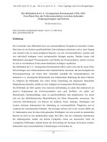
Single and multi-grain fractions of monazite and thorite from two igneous rocks within the
GHMS have been dated using the U-Pb isotope system. An undeformed, coarse grained pegmatite,
which cuts across S2 in the highly strained pelitic gneiss unit within the MCT shear zone, has an
interpreted crystallization age of 21.8 +/- 0.5 Ma. Above the high strain of the MCT shear zone, a
*) Department of Earth Sciences, Carleton University and Ottawa-Carleton Geoscience Centre, Ottawa,
Ontario K1S 5B6, Canada
**) Geological Survey of Canada, Ottawa, Ontario K1A 0E8, Canada
8thHimalaya Karakorum Tibet Workshop
Vienna 1993
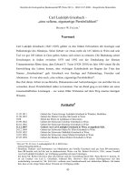
0.0038
24
-
.
0.0036
Monazite from 3
cross-cutting pegmatite
^»
^
*
R
#^
J
21.8+0.5 Ma
23
^
I
к
.X
>^
j « :
oo
22
0.0034
J
О
. /
^
. /
Thorite from
folded leucogranite
^
22.5+0.1 Ma
G yS
21
0.0032
Ь
г^у^
20
/S
0.0030
•
0.019
1
0.023
0.021
207
Pb/
235
и
multiply deformed leucogranite body in the calc-silicate gneiss unit which exhibits interference
patterns between Dl and D2 folds and contains the S2 foliation has an interpreted crystallization
age of 22.5 +/- 0.1 Ma.
The new structural and U-Pb data presented here imply the following temporal
relationships in the Kali Gandaki region: 1) peak metamorphism, anatectic melting, and
leucogranite emplacement occurred at about 22.5 Ma; 2) at least some of the Dl deformation and
all of the D2 deformation associated with the MCT occurred between 21.8 and 22.5 Ma, and
therefore, both deformation events are Himalayan in age; 3) ductile deformation on the ADF
probably happened after 22.5 Ma; 4) at 21.8 Ma ductile deformation on the MCT and possibly on
the ADF had ceased, followed by a period of extensive static recrystallization as the GHMS
cooled; 5) a subsequent pulse of movement formed chlorite-grade shears in the GHMS and a
biotite-grade crenulation in the LHSS; and 6) more recently, reactivation of both the MCT and
ADF has superimposed brittle fabrics on ductile shear fabrics.
8thHimalaya
Karakorum
Tibet Workshop
Vienna
1993
M. B R U N E L * , N. A R N A U D * * , P. T A P P O N N I E R * * * , Y. P A N * * * * & Y. W A N G * * * *
The northernmost segment of the Karakorum fault is an active normal dextal wrench fault
that bounds the Muji Tashgorgan Plio-Quaternary basin. The KongurShan (7719m) and
Mustaghata (7545m) form great antiformal domes, 25 Km wide, elongated along a direction N
1 lO.They are growing "en echelon" on the Eastern side of the Karakorum fault (1).
The Kongur antiform folds a large regional overthrust between a volcanic arc complex
and a thick (probably Permo-Carboniferous) sedimentary sequence underneath. The sediments
(red-violet to greenish-grey sandstones, shales, slates and calcschists) are affected by cascades
of recumbent, north-facing isoclinal folds, some of them reaching kilometric sizes.
The allochtonous amphibolite volcanic arc complex, is described in the Oytag Akezi area,
200 km south of Kashgar, on the north flank of the KongurShan antiform. The 3 or 4 thousand
meters thick allochtonous sequence, possibly Upper-Middle Paleozoic, consists mainly of
metabasalts, garbenschiefer amphibolites, granodiorites, gabbros and greywackes, all thrusted
above the folded and schistosed green and red sandstones formation probably of Upper
Paleozoic age. Shear senses in mylonitic gabbros (greenschist facies) at the base of the
amphibolites are consistent with emplacement of the arc complex as a NNE vergent thrustsheet. Biotites in the sole contact of the nappe yields Ar/Ar Jurassic ages of 146±0.7 Ma but
limited Quaternary displacement is also suggested. Preliminary U/Pb ages imply also Lower
Jurassic metamorphism in the Mustaghata core. The core of the Kongur antiform is made of
augengneisses and leucogranites, garnet micaschists, and chloritoid schists. Overall, the
allochtonous metabasites and the foliation in the gneisses wrap the antiformal dome but there are
local complexities. Biotite schists form a tight, NW-SE trending syncline and near-horizontal
lineation show clear evidence of right-lateral shear. The Kongur antiformal structure is
interpreted as a growing ramp anticline thrusted northwards by the Main frontal Pamir thrust
(MPT) system, over the 10 000 m thick Tarim Plio-Quaternary sediments. The Kongur massif,
on the restored cross section, therefore appears like a gigantic crustal structure 20 to 30 Km
high; the total horizontal shortening is estimated to exceed a hundred kilometres.
To the West and Southwest, the Kongur anticline is bounded by active slip normal faults,
which contribute to shape the topography of its western face. West dipping, mylonitic gneisses
at least 1000m thick with downdip lineation characterize a normal fault zone within which
plastic deformation of quartz agregates and development of shear bands and C-S structures
indicate a down to the west, shear sense along the western flank of the Kongur antiform. This
normal faulting occurs under greenschist metamorphic facies conditions allowing crystallization
of quartz-chlorite-muscovite.Those gneisses are cut by the steeper, active normal fault, a
situation reminiscent of the Miocene North-Himalayan normal fault.at Everest.To the South, die
Mustaghata (7545m) anticline is the twin structure of the Kongur, and gneisses there have given
Jurassic ages with U/Pb method on zircons, probably dating the protolith of the gneisses.
Ar/Ar ages obtained on micas, use of К feldspar Ar/Ar modelling with the multi-domain
theory and fission tracks ages performed on apatites lead to the proposal of a major contrast in
the cooling history of the Kongur-Shan gneiss antiform at 2 Ma (2) The dated minerals
crystallized or have been reequilibrated during the greenschist facies metamorphism that
*)
**)
**)
**)
Laboratoire de Tectonique, Universite de Montpellier II, France
URA 10 CRNS, Clermont Ferrand, France
Laboratoire de Tectonique, IPG Paris, France
Institute of Geology, Academia Sinica, Beijing, China
-
10
-
8thHimalaya Karakorum Tibet Workshop
Vienna 1993
prevailed during normal faulting. The cooling deduced from those therefore records cooling
after metamorphism and denudation associated with the normal fault movement. It is clear also,
that the sudden increase in cooling rate (from 50°C up to 150-250°C) at 2 Ma. does not match
only simple cooling subsequent to metamorphism in the normal fault but is related to a drastic
change in denudation related cooling.
For these reasons, it is suggested that the cooling rates record an important increase in
normal denudation at 2 Ma. Assumming a minimum geothermal gradient of 30°C/Km these
cooling rates after 2Ma. record a maximum value for footwall uplift of the normal fault at rates
of 3-5 Km/Ma. Similar rates at other localities suggest that the recovery time of isotherms after
uplift is short, and that these rates are also minimum values. Finally, from measurement of the
dip-slip component on recent fault scarps,(Liu Qing et al.,1992), concluded to a comparable
average value of 1-4 Km/Ma.of relative uplift in the late Quaternary.
Tectonic observations and rates of uplift estimates imply that the Kongur-Mustaghata
structures, which represent growing, "en echelon" ramp anticlines, at the scale of the crust, can
be explained by Southwestward subduction of the Tarim. As is in the Himalayan example we
assist to the coeval development of the frontal Pamir thrust and the rear Muji-Tashgurgan
normal fault. In each of these cases, an important delay: almost 20 Ma.is observed between the
onset of convergence and associated thrusting and the development of extensional deformation
and normal fault We suggest that an important amount of crustal thickening is necessary before
it can induce the development of normal fault
Kongur-Shan appears as an exceptional example where normal faulting contibutes to
create relief and should be regarded as the type example of orogenic extension.
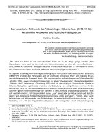
SSW
KONGUR SHAN
NNE
1-Plio-Quaternary; 2- Miocene-Oligocene; 3-Eocene; 4-Cretaceous; 5-Jurassic; 6-Triassic;
7-Devono-Carboniferous and Paleozoic; 8-Tarim Precambrian basement.
9-Amphibolitic nappe
10-Plio-Quaternary of the Muji Basin; 11-KongurShan micaschists; 12-KongurShan gneiss.
-
11
-
8thHimalaya Karakorum Tibet Workshop
Vienna 1993
References:
(1): Brunei et al., Tectonics of the Eastern Pamirs, Int. Symposium on the Karakorum
and Kunlun mountains June 5-9 1992 Kashi China, p.29.
(2)Arnaud et al., High cooling and denudation rates at KongurShan, Eastern Pamir
(Xinkiang, China) revealed by Ar/Ar Alkali feldspar thermochronology, Tectonics .submitted.
-
12
-
8thHimalaya Karakorum Tibet Workshop
Vienna 1993
M.N. CHAUDHRY*, M. GHAZANFAR* & J.N. WALSH**
This paper discusses the tectonic significance of the Permian
ianjal Volcanics of Kaghan Valley on the basis of an overview of
geology, field relations and associated rocks. It is proposed that
more than 400 km long rift related, generally terrestrial kanjal
suite developed into an incipient ocean, the lanjal Sea with
continental to oceanic transitional to oceanic crust in Kaghan area.,
iiaior element, trace element and R.E.S. characteristics appear to
corraborate this conclusion.
North of this incipient ocean lay the Kashmir Hazara
microcontinerit. The permian Pannal Sea which developed during rifting
of Gondwanalaiid closed during Triassic when the overlying Halkandi
limestone was deposited and Neo Tethys started opening to the north
of the Kashmir-Hazara microcontinent.
*) Institute of Geology, Punjab University, Quaid-e-Azam Campus, Lahore, Pakistan
**) Royal HoUoway and Bedford New College, University of London, Geology Department, Queen's Building,
Egham Hill, Egham, Surrey, TW20 OEX, United Kingdom
-
13
-
8thHimalaya Karakorum Tibet Workshop
Vienna 1993
LateOrogenic Extension in the High Himalaya:
i
M. COLCHEN*
The Thakkhola hemi-graben is located at the northern side of the Nepalese High Himalaya
(Dhaulagiri and Annapurna Ranges). It is filled with thick (900 m) detritical series of probably PlioPleistocenous age (Tetang and Thakkhola formations) (1).
Several fault systems are recognized in the Mesozoic formations, which constitutes the basement
of the southern part of the Thakkhola hemi-graben :
- a N020-N040 system, set of plurikilometric normal faults of regional extension, which are well
exposed in the western part of the basin. The fault planes dip 80 to 85° to the east, with striae pitching
15° to 30° to the north. These faults are associated with sinistral oblique-slip ones. The amplitude of
the displacement decrease from north to south: it varies from 4 km (vertical slip) and 8 km (horizontal
slip) at the north to some tens of meters 50 km to the south.
- others fault systems are recognized : N180-170, N070-090, N115, N150-160° normal and
strike-slip faults. These faults are subvertical, with minor vertical slip.
Four directions of extension are recognized:
- a WNW-ESE which fits with the Thakkhola hemi-graben formation with N020-040
normal faults,
- a N-S, with N150-160 normal faults,
- a NE-SW, with N150-160 normal faults,
- and a W-E, with N180-170 normal faults.
Two directions of compression :
- a NNW-SSE to N-S with N020-040 sinistral and N150-160 dextral strike-slip faults,;
- a E-W with N020-040 dextral and N120-150 sinistral strike-slip faults.
(1) FORTM, FREYTETP. and COLCHEN M. (1982).
In conclusion:
The superposition of the several striae assemblage on a same fault plane reveal a polyphasic
faulting in extension and compression alternately.
The disconformity between the Thakkhola fm. and the mesozoic fm. of the basement, both folded
and faulted, is the indication that a part of this faulting predates the Thakkhola hemi-graben formation.
Concerning this hemi-graben, is proposed the following chronology of the faulting from the Late
Paleogene to the present time :
1) a WNW-ESE extension characterized by N020-040 normal faults ;
2) a NW-SE to N-S compression with the N020-040 sinistral strike-slip faults and N150-160
dextral strike-slip faults;
3) a ENE-WSW to E-W compression with the N020-040 dextral and N070-090 sinistral strike-slip
faults;
4) a E-W extension with the N180-160 normal faults observed in the Thakkhola fm. and the
Quaternary fm.
This faulting is in keeping with the geodynamic evolution of the northern himalayan domains,
consequence of the continental hypercollision between India and Asia :
- the extension of the upper plate above the North Himalayan shear zone ;
- the Miocene dextral shearing between Himalaya and Tibet.
References:
ARMIJO andai. 1986, BRUNEL 1983, BURG 1983, FORT 1993, FORT and al. 1982, MERCIER
J.L. 1984,MOLNARfl«rfa/. 1975, PECKER and al. 1991,TAPPONNIERa/irfa/. 1977.
*) Laboratoire de Tectonique et Geodynamique, Universite, 40, Avenue du Recteur Pineau, 86022 Poitiers
Cedex, France
-
14
-
8thHimalaya
Karakorum Tibet Workshop
Vienna 1993
Field Study of the Western Karakorum Axial Batholith
F. DEBON* & N.A. KHAN**
The detailed study of the Karakorum axial batholith undertaken by different teams for the last
ten years has shown its composite character. Different plutonic units, dominantly ranging in age from
Cretaceous to Miocene, have been recognized. However, their inventory is far from being over, and
their extent and relationships remain often ill-defined.
Our 1992 field trip in the Karakorum range was mainly devoted to the Karambar valley (N.
Pakistan), the choice of which was based on several grounds: - the Karambar valley offers a complete
and easily accessible N-S section of the western axial batholith, perpendicular to its elongation; • this
section, hitherto poorly known (review in Casnedi, 1984), cross-cuts a cartographic plutonic "blank",
about 120 km long, separating two already investigated N-S sections of the batholith, namely the YasinDarkot and the Hunza-Batura sections. The study concerns a section around 40 km long, 28 of them for
the batholith itself.
Along the Karambar valley, surrounding rocks of the batholith are essentially made up of
metapelitic formations, usually trending WNW-ESE. Metamorphism is dominantly developed south of the
batholith, where biotite-garnet metapelites are cross-cut by a conspicuous swarm of diversified
leucocratic dykes that could be held responsible for their transformation into migmatites of the injection
type. This migmatitic zone is about 4 km wide. More to the south, around 6 km far from the batholith,
dykes almost completely disappear and metamorphism decreases abruptly (phyllites, slates).
At its northern and southern margins, the batholith intrudes metapelites along sharp, normal and
steep contacts, roughly concordant at map scale. Metasedimentary xenoliths, a metre up to several
decametres in thickness, are frequent close to either margins, particularly along the southern one
where they occur within a zone some 700 m wide. Metasedimentary rocks seem to be completely lacking
in the internal part of the batholith. The huge screen which, more to the west, divides the batholith into
two branches, does not reach the Karambar valley.
Three major types of plutonic rocks can be distinguished along the section studied: (1) strongly
foliated biotite-amphibole granodiorite, often rich in mafic enclaves, sometimes blastomylonitic,
representing the westward continuation of the well-known mid-Cretaceous calc-aikaline "Hunza
Granodiorite" (HG); (2) diversified foliated amphibole-biotite granite, locally porpyritic, corresponding
to the mid-Cretaceous subalkaline "Oarkot Pass Granite" (DPG); (3) various and more or less foliated
fine grained rocks of acidic and intermediate composition (FGR). From north to south, the arrangement of
the different units is: HG + metapelitic xenoliths (~ 0.2 km) / DPG, often porphyritic, + FGR + HG (~ 0.5
km) / DPG, often porphyritic, (~ < 1.5 km) / DPG + FGR (+ HG) (~ £ 3.5 km) / FGR + HG (often as
angular enclaves within FGR) (~ 5.5 km) / HG (~ 16 km) / HG + metapelitic xenoliths (~ 0.7 km). The
different units usually display sharp and sinuous contacts. HG was emplaced before FGR, whereas FGR
and DPG could be coeval.
On the whole, the section shows a very complex imbrication between the Hunza and Darkot Pass
plutonic units, as also between them and the fine grained igneous group (FGR), of uncertain affinity.
Numerous leucocratic dykes of various composition cross-cut the batholith. At least part of
them were emplaced during or before the deformation(s) responsible for the foliation of their host
granitoids. Their study, in relation with deformation and metamorphism, both within and out of the
batholith, remains to be done and should be of particular interest.
*) URA 69, Institut Dolomieu, 15 rue Maurice Gignoux, 38031 Grenoble Cedex, France
**) Geological Survey of Pakistan, 84-H/l, Islamabad, Pakistan
-
15
-
8thHimalaya Karakorum Tibet Workshop
Vienna 1993
M. D R A N S F I E L D *
One process leading to the exhumation of lower crustal, high-grade metamorphic
rocks is by extensional unroofing along the footwall of large-scale, low-angle normal fault
zones. Such extension is often sited along orogenic belts, where it is associated with
compressional tectonics. Detailed mapping and sampling, combined with analysis of macroand micro-structure, petrology and PT data, is being used to study the evolution of rock fabrics
and metamorphic pathways, and the history of compression and extension recorded in the
footwall metamorphic rocks of these large-scale normal faults. Field work has been conducted
in two orogenic belts; the Scandinavian Caledonides, in western Norway and the Himalaya, in
Zanskar, northern India. This presentation will concentrate on the Zanskar area.
High-grade metamorphism in the High Himalayan Crystalline Unit resulted from
thrust- and fold-related crustal thickening within the Indian plate following the collision of
India and Asia during the Eocene. The existence of a large-scale, laterally extensive, normal
fault zone bounding the northern side of the High Himalayan Crystalline Unit is now well
established, from Zanskar in the north-western Himalaya to eastern Nepal/Tibet. However, the
details of the exhumation of the high-grade metamorphic rocks, in the footwall of the normal
fault zone, remain poorly understood. In Zanskar, the normal fault is continuously exposed
along strike for over 150km and places sillimanite-grade gneisses of the High Himalayan
Crystalline unit against anchimetamorphic Tethyan sediments. Its dip varies between 20 and
45° NE. The Zanskar normal fault zone is one expression of the extension that affects a large
proportion of the Crystalline Unit in this area. The fabrics recorded by different grades of
metamorphic rocks in the footwall represent an evolution from compressional to extensional
tectonics and exhumation through different crustal levels.
Early, compressive nappe, domal and fold structures are preserved mainly in the
highest-grade rocks, in the core of the Crystalline Unit - high amphibolite facies gneisses and
migmatites. Extension begins in amphibolite facies, shown by the presence of sillimanite
growing along NE-directed extensional S-C fabrics. The later foliation, stretching lineations,
polyphase folding and boudinage structures, in the gneisses, schists and deformed
leucogranites can all be interpreted as extensional fabrics, evolving from pure to simple shear
structures as exhumation proceeded. Late, greenschist facies mylonites, mainly associated with
the fault zone itself, show many discrete shear zones and abundant, simple-shear-related
kinematic indicators, revealing a consistent top to the NE, or normal, sense of displacement.
The final stage of exhumation is accompanied by the formation of mesoscopic, brittle, normal
faults and pseudotachylite veins. Petrological and thermobarometric data will be used to
quantify this exhumational history.
A combined pure and simple shear model is suggested for the area. The simple shear
domain of the upper and middle crust has overprinted the pure shear domain of the lower crust
as the rocks were exhumed and cooled. The Main Central Thrust and the Zanskar Normal Fault
Zone appear to have been active simultaneously. The extension is thought to be a result of
gravitational collapse of the Himalayan topographic front, leading to the formation of the
Zanskar Normal Fault Zone and contributing to the exhumation of the metamorphic rocks
below the fault.
*) Department of Earth Sciences, Oxford University, Parks Road, Oxford 0X1 3PR, United Kingdom
-
16
-
8thHimalaya
Vienna 1993
Karakorum Tibet Workshop
W. F R A N K * , B . G R A S E M A N N * , P. G U N T L I * * & C h .
M I L L E R ** *
In the Crystalline nappe of the NW-Himalayas amphibolite facies tempera
tures ceased from 25-23Ma onwards. 40 Ar/ 39 Ar plateau ages of white micas from the Higher
Himalayan Crystalline (HHC) along the Chenab river S of Kishtwar typically yield cooling ages
around 22-21Ma. Biotites frequently yield ages (appr. 300°C) about 1бМа, locally also younger
ones. A rapid cooling phase is only indicated for higher temperatures, but was obviously not
active for the whole 500°C-300°C interval. From this cooling pattern it can be inferred that the
Main Central Thrust (MCT) process started not later than 23Ma.
Up to now reliable cooling ages from the metamorphosed Lesser Himalayan unit (LH) are
nearly missing. From several reasons it is difficult to obtain reliable ages from these units. The
Proterozoic granitic rocks usually have not reached total equilibrium in alpine times. Slates and
schists without major Ca-bearing mineral phase are unsuitable for Rb/Sr-dating. Excess 4oAr
(up to lxlO" 4 cm 3 STP/g) is ubiquitous in these units. Therefor the few reliable data from these
units have an important significance. The youngest ages in the Larii-Kulu-Rampur window in
dicate formation ages for the very low metamorphic zones of about 12Ma.; biotites from this
area may have passed their blocking temperature later than lOMa. Locally the HHC W of
Kishtwar window suffered a reheating from below, an interpretation based on Ar/Ar data on
biotites around 7-8Ma.
Youngest ages in the LH are derived from 1860Ma granite gneisses in Garwahl along the
Bhagirathi river below the Vaikrita thrust (main MCT). ^°Ar/39Ar-plateau ages of 4.5Ma were
measured on phengites from these rocks. Several other results on micas from this region with
different methods support a cooling history from lOMa onwards.
GEOCHRONOLOGY:
THERMAL MODELLING: Two-dimensional finite-difference thermal modelling of the overthrusting
of the HHC over the LH establishes that the shape of cooling curves for samples from the footwall and hanging wall are very sensitive to the actual displacement history. The cooling curves
deduced from mineral ages in the hanging wall are steeper between 25-15Ma and become
shallower in more recent time. Samples fonn the footwall show a temperature rise between 25lOMa followed by rapid cooling. These patterns can be numerically modeled assuming an in
itial displacement of about 10mm/a and crustal thickening of 10km, which produces an ele
vated geothermal gradient and warming of the footwall. From appr. 15Ma onwards the hang
ing wall was exhumed at a rate of about lmm/a. The rapid cooling of the samples in the
footwall at around lOMa can be explained by an exhumation rate of about 1.5mm/a or higher,
which was caused by rapid uplift near extensional faults.
The thermal history of the HHC is closely connected with the detailed palaeogeographic position of the different units at the former border zone between the LH and
HHC units. It has important consequences if the present southern front of the HHC was near
to the leading edges of the overthrust along the MCT or far behind it.
PALAEOGEOGRAPHY:
*) Institute for Geology, University of Vienna
**) Institute for Petrography, ETH Zürich
***) Institute for Mineralogy and Petrography, University of Innsbruck
17
-
8thHimalaya
Karakorum
Tibet
Workshop
Vienna
From our geochronological data of the Proterozoic sequences, from field work in the
Lahul/Chamba region and the similarities between the Simla Slates and the Haimantas we
reject the widely accepted interpretation that the Simla Slate - Krol sequence was deposited on
the Early to Middle Riphean Shah - Deoban carbonate platform. We propose an alternative
model in which the Simla - Krol sequence was deposited in the southern continuation of the
vast clastic Haimanta sedimentary pile, which often exhibit a flyschtype character and got their
clastic material from a northern region.
We assume that the northern Chail series (without carbonates) or the Jutoghs and their
equivalents (Lower Crystalline nappe in the sense of G. FUCHS) may have been the former
basement of the Simla Slates.
In a first phase of the MCT process the Simla/Krol sequence together with the main HHC
began to move along a nearly horizontal thrust plane with ramps. In a second phase the thin
leading edge of the overthrust unit (i.e. the Simla/Krol unit) was overridden by the main mass
of the HHC and parts of the Chail units, forming now some kind of a giant duplex structure.
This interpretation has several consequences apart from palaeogeographic and lithostratigraphic aspects: the thrust distance between the HHC and LH should be extended by the order of 100km. This special setting and the geometry of the initial MCT-process greatly facilitates the evolution of the reversed metamorphic sections. The present stacking: Chail units /
Lower Crystalline nappe / HHC may have developed for some Ma in the first stage by thrusting hot material on already warm substrate and the reversed metamorphism developed in the
associated shear regime of considerable thickness. The geochronological results of the cooling
pattern are in better correspondence with this new inodel than with a very rapid thrusting of
hot on cool elements.
-
18
-
1993
8thHimalaya
Karakorum
Tibet Workshop
Vienna
—~~-~~""~~-"^^
G. F U C H S * & M. LINNER**
It is significant that there exists no sharp boundary between the Lamavuru Unit
e Zanskar shelf series (FUCHS, 1986). In the Khurnak syncline the complete Precambrian-Eocene succession is exposed. The Triassic series-exhibit distinct Lamayuru fades. Though blue limestones gain importance towards me S the euxinic facies persists
in the Norian series till Marang La. The thrust of this pass demarkates a change in
facies, and therefore indicates at least several kilometers of transport. In the N we find
the euxinic Norian and a lenticular red riff body at the base of the Kioto Limestone,
whereas in the S the greenish-grey Monotis Shales are succeeded by the Quartzite Beds
and then the Kioto Limestone follows. In the Tsarap Valley a complex, partly sheared
syncline contains Jurassic-Cretaceous series up to the Kangi La Formation (Campanian).
The Sarchu Shear Zone, comparable to the Zanskar Shear Zone (HERREN,
1987), influenced the pre-existing structures on both sides. In the N the vergence is
generally SW, but in the vicinity of the shear zone folds are directed NE. In the S the
huge recumbent folds in the Palaeozoics are the product of dragging near the shear
zone. There is also a hiatus in the grade of metamorphism - it is much higher in the
footwall. During the activity of the shear zone the conditions changed from ductile shear
to steep planes with cataclasis.
In the fold belt of Lahul we find Haimantas (Phe) and Parahio (Karsha) Formation with a few Palaeozoc synclines. The Tandi Syncline still is an enigma. It consists
of carbonates of Jurassic age (PICKET et. al., 1975) bordering Precambrian Haimantas
without a trace of any Palaeozoic or Triassic formations. The fold, however, is directed
NE and not plunging SW.
In Chamba the age of the Manieer Conglomerate is a major problem. From the
Sach Pass section FUCHS (1975) did not hesitate to correlate with the Agglomeratic
Slate (Up.Carb.). FRANK found the boulder slates underlying Haimantas and therefore
suggests a Late Precambrian age (pers.comm.). In fact we substantiated the observation:
At Tindi (Chandra Valley), the Chobia Pass, and ENE Barmaur the Manjeer Conglomerates are overlain by Haimantas. From the lithology of the conglomerates and their
association with carbonates and black slates there is no doubt that there is only one such
series in Chamba, and that the "intra-Haimanta" conglomerates are connected with the
Manjeer Conglomerates of the Kalhel Syncline. There they are associated with fossiliferous Late Palaeozoic and Triassic sediments and the Panjal Trap. Thus we favour
a Late Palaeozoic age of the Manjeer Conglomerates, which implies overthrusting of
Haimantas in the area SE of the Sach Pass.
The Early Palaeozoic Granite intrudes Haimantas in the Dhauladhar Range.
Between the Crystalline Nappe and the Murrees of the Tertiary Zone in Dharamsala
basic volcanics, Eocene Subathus, and a scale of Shali Limestone and black slates are
squeezed and inverted.
Fuchs, G. (1975): Abh. Geol. B.-A. 32, 59p.
Fuchs, G. (1986): Jb. Geol. B.-A. 128, (3 + 4), 408-437.
Herren, E. (1987): Geology 15, 409-413.
Picket, J. et. al. (1975): Alcheringa 1, 71-85.
a n d th
*) Geologische Bundesanstalt, Rasumofskygasse 23, A-1030
*) Institut für Petrologie, Universität Wien, Dr. Karl Lueger-Ring 1, A-1010 Wien, Austria
-
19
-
1993
8thHimalaya
Karakorum Tibet Workshop
Vienna 1993
M. GAETANI*, A. NICORA*, L. ANGIOLINI* & P. L E FORT**
In the easternmost Hindu Kush, Hindu Raj and W Karakorum, the
following units may recognized from south to north:
1) The Axial Batholith forms two distinct branches in this
region. They are separated by a band of metasediments already
described east of this zone as the Darkot Group, of Permian age
pro parte. Possible Mesozoic fossils have been obtained.
The
Yarkhun river only cuts through the northern branch where two
types of granitoid have been recognized: (i) a dark amphibolebiotite granodiorite to biotite, rich in mafic enclaves, often
foliated, resembling the Hunza granodiorite of mid-Cretaceous age,
(ii) a porphyritic biotite ± amphibolite granite, often strongly
deformed, more abundant to the north of the section, where it
intrudes into the metasedimentary formations with a diffuse
contact.
This second type, resembling the subalcaline midCretaceuos Darkot pass granite, is intimately associated with the
first, a situation similar in some way to that of the Karambar
section (see Debon & Khan Abstract).
2) North of the Axial Batholith mostly sedimentary rocks
crop out, usually arranged in three stacks, thrusted southwards.
The crystalline basement of the middle stack has been discovered.
It is made up of a medium grained biotite granite, largely eroded
in a glacial basin, due to its very strong alteration and brittle
deformation. To the south, the granite intrudes the dark
metapelites of Chikar. The sedimentary succession is directly
trangresssive on the granite with conglomerates and siltites, in
which Early Ordovician acritarchs have been detected
(M.
Tongiorgi, Pisa). The succession continues upwards with a
terrigenous
unit,
hundreds
m-thick,
with
rare
dolomitic
intercalations in which Talent et al. (1981) found Middle-Upper
Ordovician conodonts.
The first significant carbonate unit
consists of about 150 m of yellow well bedded dolomites, with
peritidal depositional characters. Supposed age: Devonian.
A
mixed terrigenous carbonate unit, locally extremely rich in
corals, brachiopods and bryozoans follows. Field identification:
Middle Devonian and Frasnian. Upwards about 100 m of grey
wackestone-crinoidal packstones follows, with solitary corals.
Supposed age: Carboniferous.
The lower part of the Permian is
terrigenous and it is correlatable with the Gircha Fm. of the
Hunza region. Then a mixed carbonate-terrigenous succession,
several
hundreds
m-thick
follows,
locally
crowded
with
brachiopods, corals, bryozoans, conodonts, gastropods, bivalves
and especially fusulinids. For details refers to Angiolini et al.
*) Dipartimento di Scienze della Terra, Milano, Italy
*) URA 69, Institut Dolomieu, Grenoble, France
-
20
-
8thHimalaya
Karakorum Tibet Workshop
Vienna 1993
(Poster Section). After an erosional surface, with local emersions
and a thin terrigenous unit, a huge peritidal dolomitic formation,
700 m, thick follows. The paleontological control is poor and we
suppose it represents the Upper Permian and may be the Triassic up
to the Early Jurassic. We have no informations about most of the
Mesozoic. The southernmost thrusted slice may have at its top the
Reshun Conglomerate with Orbitolina-bearing pebbles.
3) A system of sinistral strike-slip faults, SW-NE oriented,
the Tirich Mir Fault, brings in contact grey pale dolomites, with
low metamorphic grade. Phantoms of ? Devonian and Triassic fossils
have been found. Most significant are mafic metatuffs and various
detrital volcanogenic levels, dark red to dark green, interbedded
with the sediments.
4) With faulted contact, the huge, several km-thick Wakhan
Slates follows. They are intruded by granitoid bodies made up in
general of biotite-amphibole porhyritic granite. A single
granitoid pluton (Chatteboj), with a strong contact aureole, was
found also intruded in the unit 2). All these granitoid bodies
could pertain either to the northern granitoid belt running from
Tirich Mir to Khunjerab, in which Cretaceous ages have been
obtained, or to the Batura group of Eocene age.
-
21 -
8th Himalaya Karakoru,
1
t\\
к t
4V
••WH'"]F""Hl¥lTf
The Himalay
Seen from В
nrfniiHfcnnwa л п м и Г "
-^-^^----^^ihift^iniMltin 1 "**--**-^--*---*-
A. GANSSER*
Most of the publications on the wider Himalayas
deal with the western and central part with easier access,
better exposures, climate and lesser political restrictions.
This changes drastically from Sikkim to the east with diffi
cult field conditions, over 10 m rain in Assam and restrictions
for foreign investigators. It is the domain of the geologists
of the Geological Survey of India , their eccellent work only
partly published and without regional maps* My own experience
in this area,apart of an investigation of satellite photos co
vering the wider Himalayas, are expeditions into the Bhutan
Himalayas from 1963.to 1977.
The geology of Bhutan represents the eastern Himalayas
and differs in many aspects from the more western regions.
The over 17 km thick central crystalline thrustsheet is more
widespread and exposes throughout a remarcable reversed metamorphism, increasing northwards with large intrusiones of leucogranites. It decreases suddenly towards the Tibetan border with the
transgressive tethyan sediments, which also occur in some isolated
basins on top of the crystallines. No tethyan faultzone exists in
decreasing metamorphism,
the north and the earliest fossils,after
suggest an Ordovician age. The Lesser Himalaya forms a narrow
band but opens eastwards into a large, northwards directed spur
with complicated internal tectonics» emphasized by slices of over
1000 my old granitoids in late Precambrian sediments,dominated
by 5000 m thick quartzites. From this spur all along the eastern
Lesser Himalayas outcrops a steep narrow band of Permo-Carboniferous , coal-bearing Damudas, bordering along the МВТ the constant
belt of Siwaliks, interrupted only along the western Bhutan foot
hills, overthrust by the Lesser Himalaya. This coincides with a
remarcable shallowing of the Brahmaputra basin with 5hillong
elements outcropping only 35 km to the south of the МВТ, the
narrowest spot of the whole Himalayan foreland.
All the elements from Bhutan can be followed through
the eastern Himalayas until the East Himalayan "syntaxis".
The narrow Damuda belt opens along the Siang river (N5 directed
Brahmaputra), with the incoming Permian Abor volcanics, the
equivalent of the West Himalayan Panjal traps, both volcanics
restricted to the west and east end of the Himalayas. The Abor
volcanics form a complicated north plunging antiform with a
window of marine Eocene in the Siang gorge, its size similar to
the Hazara-Kashmir "syntaxis" in the west. The equivalent of the
Nanga Parbat uplift in the east Himalayas could be the Namche
*) Via Rovello 23, CH-6900 Massagno-Lugano, Switzerland
-
22
-
8thHimalaya
Vienna 1993
Karakorum Tibet Workshop
Barwa high, though the structural connections with the Abor spur
are still vague. The Himalayas do not end with the respective
syntaxis but with remarcable fault and thrustzones, the 5arobi
and Chaman faults in the west, the Mishmi thrust in the east.
Both Himalayan ends and the respective continuations along the
west and east border of the Indian shield are strikingly diffe
rent. The west is characterised by widespread evaporites, out
cropping in the salt range, forming an important decollement ho
rizon . They are responsible for the discrepancies between sur
face and subsurface structures. Evaporites are so far unknown in
the eastern Himalayas except for some late Precambrian-Cambrian
gypsum horizons in the Shumar spur of the Lesser Himalaya in
southeast Bhutan» A 6000 m thick Eocene flysch belt grading into
a younger molasse followes the allochtonous Quetta and Las Bela
ophiolites,thrust on the west border of the Indian shield.
A similar flysch zone, here with exotic blocks, is related to the
allochtonous Naga ophiolites of the Indo-Burman ranges. They are
thrust towards the Shillong and Mikir massives of the
eastern
Indian shieldo No similar flysch development is known from the
main Himalayan range. The outstanding,southeast striking Mishmi
thrust which overrides even Quaternary sediments, cuts all the
main Himalayan elements as well as all the Indo-Burman ranges.
The complete tethyan Himalaya has disappeared between a thin
crystalline belt and the still enigmatic Tidding
ophiolite zone,
which continues into the western border of the Burmese Shan plateau.
The Tidding zone is southwestwards overthrust by granites reminis
cent of the Transhimalaya»:
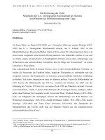
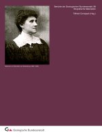
THE WIDER EASTERN HIMALAYAS
A Amdo, D Darjeeling, L Lhasa,
T Timphu(Bhutan), S Shumar
NB Namche Barwa,
NT Nienchen Tangla
LH Lower Himalayas
HH Higher Himalayas
TH Tibetan (Tethys) Himalayas
:::;::::;.
Molasse
~-~—~-~- Flysch
Eocene windows
-Ophiolites i.g.
v v v v v Abor volcanics
- .with Damuas
л"«"х» Tibetan granitoids
* X X Transhimalayan
Г
УУ££
s
Gr.
Tibetan basement
;-'0' 4 Indian Shield and
Shan Plateau
(Burma)
strike lines
faulTs, fractures
thrusts
200 K m
-
23
-
8thHimalaya
Karakorum Tibet Workshop
Vienna 1993
It is most conpicuous how the eastern Himalayas, the
Mishmi hills as well as the Indo-Burman ranges encroached for
hundredsof kilometers from the north, the northeast and the
southeast on the Shillona shield and its northeastern continuation under the Assam basin,with several thousand meters of
Neogene and Quaternary sediments.
In spite of recent seismicity,trending north-south in the middle of the basement, this
northeastern continuation of the Indian shield has remained fixedo
-
24 -
8thHimalaya
Karakorum Tibet Workshop
Vienna 1993
E. GARZANTI*, F. BERRA*, F. JADOUL* & A. NlCORA*
The complete Paleozoic and Mesozoic stratigraphy of the Northern Indian
continental margin was reconstructed from several detailed sections
measured in 1992 along the Pin and Parahio Valleys, in the KibberChikkirn area and along the Kunzam La-Losar-Kiato profile.
A very thick succession of shallow-water fine-grained sandstones and
pelites, with only a few intercalated dolostone beds at the top, was
deposited in the Late Precambrian? and Cambrian. A thin biocalcirudite
marker horizon was found in the Kunzam La area 485 m below the top of
the unit» Similar carbonate beds occur also in Pin Valley.
Next, a major break is marked by a low-angle unconformity, best exposed
north of Kunzam La and ascribed to the Late Pan-African erogenic pulse,
overlain by an up to 783 m thick redbed "molasse" of Ordovician age.
The following unit is still arenaceous in the Takche area, and becomes
more calcareous eastwards. At Muth it is 243 m thick and contains
several limestone intervals, ironstone beds in the lower part and patch
reefs at the top. It is overlain by 224 m of pure (eolian?) white
quartzarenites, followed in turn by alternating hybrid dolomitic
arenites and pure quartzarenites (55 to 92 m ) . At Losar this upper
interval is much thicker (about 250 m) and characterized by restricted
to open marine facies, including biocalcarenites and coral patch reefs.
Fossiliferous, storm-deposited arenaceous limestones (61 m at Muth),
passing upward to dolostones and shale (64 m at Muth) were deposited in
the Early Carboniferous; this succession is followed by white gypsum
layers in the Losar area»
The Upper Paleozoic was characterized by major tectonic activity,
leading to extreme topographic irregularities sealed by the Upper
Permian Kuling Formation. In the Spiti Valley, the latter unit overlies
a very thick terrigenous section, consisting of tidal quartzarenites
and shales (well over 353 m thick at Losar), Fenestella-bearing
shales
(about 100 to 150 m thick at Losar), orange-weathering quartzarenites
(123 m thick at Losar) and brownish sandstones, paraconglomerates and
black pelites with dropstones (around 300 m thick at Losar and well
over 150 m also at Lingti). In the Pin Valley, instead, the Upper
Paleozoic section is largely eroded, and the Kuling Fm. disconformably
overlies Silurian arenites to Devonian quartzarenites separated by
paleofaults (Parahio Valley), or Lower Carboniferous limestones (Pin
Valley).
The Kuling Fm. (63 to 95 m thick) consists of 0.4 to 35 m thick basal
conglomeratic arenites, comprising ironstone layers at the base and
top, overlain by black phosphatic pelites rich in Spiriferid and
Productid brachiopods (52 to 93 m thick). In the Parahio Valley the
basal arenites are only 0.4 to 2.1 m thick, whereas in the Pin Valley
*) Dipartimento di Scienze della Terra, Via Mangiagalli 34,1-20133 Milano, Italy
-
25
-