ArcGis blueprints exlore the robust features of python to create real world
Bạn đang xem bản rút gọn của tài liệu. Xem và tải ngay bản đầy đủ của tài liệu tại đây (11.73 MB, 378 trang )
ArcGIS Blueprints
Explore the robust features of Python to create
real-world ArcGIS applications through exciting,
hands-on projects
Eric Pimpler
BIRMINGHAM - MUMBAI
ArcGIS Blueprints
Copyright © 2015 Packt Publishing
All rights reserved. No part of this book may be reproduced, stored in a retrieval
system, or transmitted in any form or by any means, without the prior written
permission of the publisher, except in the case of brief quotations embedded in
critical articles or reviews.
Every effort has been made in the preparation of this book to ensure the accuracy
of the information presented. However, the information contained in this book
is sold without warranty, either express or implied. Neither the author nor Packt
Publishing, and its dealers and distributors will be held liable for any damages
caused or alleged to be caused directly or indirectly by this book.
Packt Publishing has endeavored to provide trademark information about all of the
companies and products mentioned in this book by the appropriate use of capitals.
However, Packt Publishing cannot guarantee the accuracy of this information.
First published: December 2015
Production reference: 1151215
Published by Packt Publishing Ltd.
Livery Place
35 Livery Street
Birmingham B3 2PB, UK.
ISBN 978-1-78528-622-3
www.packtpub.com
Credits
Author
Eric Pimpler
Reviewers
Chad Cooper
Project Coordinator
Nidhi Joshi
Proofreader
Safis Editing
Eleza Boban Kollannur
Prasad Lingam
Shaik Shavali
Commissioning Editor
Akram Hussain
Acquisition Editor
Vinay Argekar
Content Development Editor
Siddhesh Salvi
Technical Editor
Vishal Mewada
Copy Editor
Stuti Srivastava
Indexer
Priya Sane
Graphics
Kirk D'Penha
Production Coordinator
Shantanu N. Zagade
Cover Work
Shantanu N. Zagade
About the Author
Eric Pimpler is the founder and owner of GeoSpatial Training Services
( and has over 20 years of experience
implementing and teaching GIS solutions using Esri, Google Earth, Google Maps,
and open source technologies. Currently, he focuses on ArcGIS application
development with Python and the development of custom ArcGIS Server
web and mobile applications using JavaScript.
Eric is the author of Programming ArcGIS 10.1 with Python Cookbook, Programming
ArcGIS with Python Cookbook - Second Edition, Building Web and Mobile ArcGIS Server
Applications with JavaScript, and the soon to be published ArcGIS Blueprints.
He has a bachelor's degree in geography from Texas A&M University and a
master of applied geography degree with a concentration in GIS from Texas
State University.
About the Reviewers
Chad Cooper has worked in the geographic information systems realm for 13
years in technician, analyst, and developer roles. He is currently a solutions engineer
with Geographic Information Services, Inc. ( where he
works on a variety of projects for the state and local government teams. Chad has
been published in Esri's ArcUser magazine and the Python magazine. He lives in
northwest Arkansas with his beautiful wife and three children.
Eleza Boban Kollannur is an architect and environmental planner working
as a GIS analyst in the water and waste water sector for more than 6 years. She
is passionate about the development of automation and programming solutions
through model building and Python scripting. She has been involved in master
planning and coastal and marine projects for the preparation of a water balance
model, watershed analysis, network model builds, and spatial analysis. She has
worked with MWH Global and DHI India for various projects in the Middle
East, India, and UK. Eleza is interested in building custom user interface (UI)
geoprocessing tools for ArcGIS desktop and server with Python.
Prasad Lingam has been passionately exploring geoinformation technologies for
almost 10 years. He has gained knowledge in the application of geoinformatics to
areas such as urban planning, transportation, utilities, environment, and construction
management, thus leveraging his civil engineering background. He is currently
working at MWH (for more information, visit in the
water and waste water domain, implementing geospatial analysis in Desktop GIS
and promoting web- and mobile-based GIS Applications to solve operational and
planning issues. His work experience spans project locations such as Perth, Middle
East, New Zealand, Fiji, and India. He is keen about studying the confluence of
geospatial technologies with technologies such as big data, BIM, geovisualization,
and so on.
Shaik Shavali is a senior GIS developer at Dar Al-Riyadh. He has 7 years
of experience in the field of geospatial technologies and projects. His areas of
expertises are developing custom GIS web and mobile applications using the latest
ESRI technologies. He was one of the lead developers for Emergency Response
Management Systems for the largest Islamic pilgrimage (Hajj), gathering nearly
2 million people. Currently, he is actively taking part in designing and developing
GIS projects for the government sector in Saudi Arabia.
He has received his bachelor's in engineering degree, and presently, he is pursuing
his master's in GIS through UNIGIS.
Firstly, I would like to thank Allah for his countless blessings. I
would also like to thank my parents (Akbar Saheb and Fathima),
in-laws (Ehasanulla and Shahnaz), and family for their emotional
support, guidance, and prayers. Finally, I would like to thank my
better-half, Farheen Ehasanulla, for her love and support, which
always pushed me to do better. She is my backbone, best critic, and
most importantly, my best friend.
www.PacktPub.com
Support files, eBooks, discount offers, and more
For support files and downloads related to your book, please visit www.PacktPub.com.
Did you know that Packt offers eBook versions of every book published, with PDF
and ePub files available? You can upgrade to the eBook version at www.PacktPub.com
and as a print book customer, you are entitled to a discount on the eBook copy. Get in
touch with us at for more details.
At www.PacktPub.com, you can also read a collection of free technical articles, sign
up for a range of free newsletters and receive exclusive discounts and offers on Packt
books and eBooks.
TM
/>
Do you need instant solutions to your IT questions? PacktLib is Packt's online digital
book library. Here, you can search, access, and read Packt's entire library of books.
Why subscribe?
• Fully searchable across every book published by Packt
• Copy and paste, print, and bookmark content
• On demand and accessible via a web browser
Free access for Packt account holders
If you have an account with Packt at www.PacktPub.com, you can use this to access
PacktLib today and view 9 entirely free books. Simply use your login credentials for
immediate access.
Table of Contents
Prefacev
Chapter 1: Extracting Real-Time Wildfire Data from ArcGIS
Server with the ArcGIS REST API
1
Design2
Creating the ArcGIS Desktop Python Toolbox
4
Working with tool parameters
10
Tool execution
12
Populating the feature class
14
Installing pip and the requests module
15
Requesting data from ArcGIS Server
16
Inserting data in a feature class with the ArcPy data access module
19
Summary22
Chapter 2: Tracking Elk Migration Patterns with GPS and ArcPy
23
Chapter 3: Automating the Production of Map Books with
Data Driven Pages and ArcPy
49
Design24
Creating migration patterns for Python toolbox
25
Creating the Import Collar Data tool
26
Reading data from the CSV file and writing to the feature class
30
Making the data frame and layer time-enabled
36
Coding the VisualizeMigration tool
42
Summary48
Design
Setting up the Data Frame
Creating the Grid Index Features
Enabling Data Driven Pages
Creating the Locator Map
[i]
50
50
54
58
60
Table of Contents
Adding dynamic text to the layout
66
Exporting the map series with ArcPy mapping
69
Summary77
Chapter 4: Analyzing Crime Patterns with ArcGIS Desktop,
ArcPy, and Plotly (Part 1)
79
Chapter 5: Analyzing Crime Patterns with ArcGIS Desktop,
ArcPy, and Plotly (Part 2)
123
Chapter 6: Viewing and Querying Parcel Data
153
Chapter 7: Using Python with the ArcGIS REST API and
the GeoEnrichment Service for Retail Site Selection
191
Chapter 8: Supporting Search and Rescue Operations with
ArcPy, Python Add-Ins, and simplekml
221
Design
80
Creating the Import Records tool
81
Creating the Aggregate Crimes tool
100
Building the Create Map tool
106
Performing Spatial Statistical Analysis
118
Summary122
Design124
Getting to know Plotly
125
Creating the Neighborhood Bar Chart tool
126
Creating the Create Line Plot tool
137
Creating the output
143
Summary151
Design154
Creating a user interface with wxPython
155
Creating the ArcGIS Python add-in
175
Summary189
Design192
Creating the Census Block Group selection tool
194
Creating the Define Potential Stores tool
202
Creating the Enrich Potential Stores tool
208
Summary
220
Design222
Creating the Last Known Position tool
224
Creating the Search Area Buffers tool
237
Creating the Search Sector tool
240
Creating the Convert to Google Earth tool
243
Summary252
[ ii ]
Table of Contents
Chapter 9: Real-Time Twitter Mapping with Tweepy, ArcPy,
and the Twitter API
253
Chapter 10: Integrating Smartphone Photos with ArcGIS
Desktop and ArcGIS Online
283
Appendix: Overview of Python Libraries for ArcGIS
323
Design254
Extracting Tweet geographic coordinates with tweepy
255
Scheduling the script
264
Creating the heatmap
270
Summary282
Design284
Taking photos
285
Converting iPhone photos to a feature class
288
Creating a Web Map
313
Summary321
Overview of Arcpy
The ArcPy classes
323
324
FeatureSets and Recordsets
324
Fields325
The geometry
325
Graphing325
General326
The ArcPy functions
326
The data store
326
Describing the data
327
Environment variables
327
Fields327
General327
Geodatabase administration
328
Geometry328
Getting and setting parameters
328
Licensing and installation
329
Listing data
329
Messaging and error handling
329
The progress dialog
330
Publishing330
Raster330
Tools and toolboxes
330
Overview of the ArcPy mapping module
ArcPy mapping classes
Mapping documents and associating dataset classes
Data Driven Pages classes
Classes related to managing time layers
Element classes associated with the layout view
[ iii ]
331
331
332
334
334
335
Table of Contents
PDF document creation and editing
336
Symbology337
Arcpy mapping functions
338
Exporting and printing maps
Managing map documents and layers
338
339
Overview of the Arcpy data access module
ArcPy data access classes
Arcpy data access functions
340
341
342
An overview of the ArcGIS REST API
Basics of using the ArcGIS REST API
Esri services
342
343
347
List functions
NumPy Array conversion functions
Your own services
Managing your organization
Administering your server
Administering Portal
Administering ArcGIS Online hosted services
342
342
347
349
350
351
351
Conclusion352
Index353
[ iv ]
Preface
ArcGIS Desktop 10.3 is the leading desktop solution for GIS analysis and mapping.
The ArcPy site package, which contains the ArcPy mapping and Data Access
modules, enables Python programmers to access all the GIS functionalities provided
through ArcGIS Desktop. ArcPy can be integrated with other open source Python
libraries to enhance GUI development; create stunning reports, charts, and graphs;
access REST web services; perform statistics analysis; and more. This book will teach
you how to take your ArcGIS Desktop application development skills to the next
level by integrating the functionality provided by ArcPy with open source Python
libraries to create advanced ArcGIS Desktop applications.
In addition to working with the ArcPy, ArcPy Mapping, and ArcPy Data Access
modules, the book also covers the ArcGIS REST API and a wide variety of open
source Python modules, including requests, csv, plotly, tweepy, simplekml,
wxPython, and others.
What this book covers
Chapter 1, Extracting Real-Time Wildfire Data from ArcGIS Server with the ArcGIS REST
API, describes how to use the ArcGIS REST API with Python to extract real-time
wildfire information from an ArcGIS Server map service and write the data to a local
geodatabase. A Python Toolbox will be created in ArcGIS Desktop to hold the tools.
Chapter 2, Tracking Elk Migration Patterns with GPS and ArcPy, teaches you how to
read a CSV file containing the GPS coordinates of elk migration patterns and write
the data to a local geodatabase. The ArcPy mapping module will then be used to
visualize time-enabled data and create a series of maps that show the migration
patterns over time.
[v]
Preface
Chapter 3, Automating the Production of Map Books with Data Driven Pages and ArcPy,
shows you how to use the Data Driven Pages functionality in ArcGIS Desktop along
with the ArcPy mapping module to automate the production of a map book. The
use of Python add-ins for ArcGIS Desktop for user interface development will also
be introduced.
Chapter 4, Analyzing Crime Patterns with ArcGIS Desktop, ArcPy, and Plotly - Part 1, is
the first of two chapters that covers the creation of ArcPy scripts for crime analysis.
In this first chapter, you'll learn how to use the Python requests module to extract
crime data from the city of Seattle's open database and write to a local geodatabase.
You'll then write custom script tools to aggregate the crime data at various
geographic levels and create maps that can be printed or exported to a PDF format.
Chapter 5, Analyzing Crime Patterns with ArcGIS Desktop, ArcPy, and Plotly - Part 2,
is the second of two chapters that covers the creation of ArcPy scripts for crime
analysis. In this chapter, you'll learn how to use the Plotly platform and the Python
module to create compelling graphs and charts of crime data that can be integrated
into the ArcGIS Desktop layout view for printing and export.
Chapter 6, Viewing and Querying Parcel Data, teaches you how to use the wxPython
module to create advanced graphical user interface (GUI) applications for ArcGIS
Desktop using Python within the context of an application that queries and views
parcel data. Python add-ins for ArcGIS Desktop will also be used in the creation of
the application.
Chapter 7, Using Python with the ArcGIS REST API and GeoEnrichment Service for Retail
Site Selection, teaches you how to use the ArcGIS Online GeoEnrichment Service with
Python to retrieve demographic and lifestyle information to support the site selection
process of a new store location. You'll also build tools to interactively select the
potential geographic location of stores based on demographic factors.
Chapter 8, Supporting Search and Rescue Operations with ArcPy, Python Add-Ins, and
simplekml, teaches you how to build a Search and Rescue (SAR) application that
identifies the last known location of the subject, creates search sectors in the support
of operations, and exports the data to Google Earth for visualization purposes.
Chapter 9, Real Time Twitter Mapping with Tweepy, ArcPy, and the Twitter API, covers
the mining of a live stream of tweets containing specific terms and hash tags. Tweets
that contain geographic coordinates will be written to a local geodatabase for further
analysis. In addition, several tools will be created to enable the analysis of this social
media data. Finally, the results will be shared with the public through the ArcGIS
Online service.
[ vi ]
Preface
Chapter 10, Integrating Smart Phone Photos with ArcGIS Desktop and ArcGIS Online,
covers the creation of a real estate application that reads photo metadata, extracts
the coordinate information, retrieves the nearest address to the photo, and writes
this information to a local feature class. In addition, the photos will be copied to
a Dropbox account using the Python Dropbox module so that the photos can be
accessed through a web application. Finally, the property feature class will be
uploaded to ArcGIS Online, integrated with the Dropbox photos, and shared
as a web-based map.
What you need for this book
ArcGIS Blueprints is written for ArcGIS Desktop 10.3. However, ArcGIS Desktop
10.2 can be used for most of the chapters as well. Python 2.7, along with the IDLE
development environment, is installed along with ArcGIS Desktop, so no additional
installations of Python should be performed. If desired, you can use your preferred
Python development environment. I recommend PyScripter if you don't have
a preference.
Who this book is for
ArcGIS Blueprints is written for intermediate-level ArcGIS Desktop programmers
who wish to take their development skills to the next level. This book will cover
intermediate to advanced level ArcGIS Desktop development topics with ArcPy
and a variety of open source Python libraries to create applications for a wide
array of topics.
Conventions
In this book, you will find a number of text styles that distinguish between different
kinds of information. Here are some examples of these styles and an explanation of
their meaning.
Code words in text, database table names, folder names, filenames, file extensions,
pathnames, dummy URLs, user input, and Twitter handles are shown as follows:
"The ArcPy data access module that is arcpy.da."
[ vii ]
Preface
A block of code is set as follows:
def getParameterInfo(self):
"""Define parameter definitions"""
param0 = arcpy.Parameter(displayName = "ArcGIS Server Wildfire
URL", \
name="url", \
datatype="GPString", \
parameterType="Required",\
direction="Input")
When we wish to draw your attention to a particular part of a code block,
the relevant lines or items are set in bold:
parameterType="Required",\
direction="Input")
params = [param0, param1]
return params
Any command-line input or output is written as follows:
# cp /usr/src/asterisk-addons/configs/cdr_mysql.conf.sample
/etc/asterisk/cdr_mysql.conf
New terms and important words are shown in bold. Words that you see on the
screen, for example, in menus or dialog boxes, appear in the text like this: "You can
create a Python Toolbox in a folder by right-clicking on the Folder and navigating to
New | Python Toolbox."
Warnings or important notes appear in a box like this.
Tips and tricks appear like this.
Reader feedback
Feedback from our readers is always welcome. Let us know what you think about
this book—what you liked or disliked. Reader feedback is important for us as it helps
us develop titles that you will really get the most out of.
[ viii ]
Preface
To send us general feedback, simply e-mail , and mention
the book's title in the subject of your message.
If there is a topic that you have expertise in and you are interested in either writing
or contributing to a book, see our author guide at www.packtpub.com/authors.
Customer support
Now that you are the proud owner of a Packt book, we have a number of things to
help you to get the most from your purchase.
Downloading the example code
You can download the example code files from your account at http://www.
packtpub.com for all the Packt Publishing books you have purchased. If you
purchased this book elsewhere, you can visit />and register to have the files e-mailed directly to you.
Downloading the color images of this book
We also provide you with a PDF file that has color images of the screenshots/
diagrams used in this book. The color images will help you better understand the
changes in the output. You can download this file from ktpub.
com/sites/default/files/downloads/ArcGISBlueprints_ColoredImages.pdf.
Errata
Although we have taken every care to ensure the accuracy of our content, mistakes
do happen. If you find a mistake in one of our books—maybe a mistake in the text or
the code—we would be grateful if you could report this to us. By doing so, you can
save other readers from frustration and help us improve subsequent versions of this
book. If you find any errata, please report them by visiting ktpub.
com/submit-errata, selecting your book, clicking on the Errata Submission Form
link, and entering the details of your errata. Once your errata are verified, your
submission will be accepted and the errata will be uploaded to our website or added
to any list of existing errata under the Errata section of that title.
To view the previously submitted errata, go to />content/support and enter the name of the book in the search field. The required
information will appear under the Errata section.
[ ix ]
Preface
Piracy
Piracy of copyrighted material on the Internet is an ongoing problem across all
media. At Packt, we take the protection of our copyright and licenses very seriously.
If you come across any illegal copies of our works in any form on the Internet, please
provide us with the location address or website name immediately so that we can
pursue a remedy.
Please contact us at with a link to the suspected
pirated material.
We appreciate your help in protecting our authors and our ability to bring you
valuable content.
Questions
If you have a problem with any aspect of this book, you can contact us at
, and we will do our best to address the problem.
[x]
Extracting Real-Time Wildfire
Data from ArcGIS Server with
the ArcGIS REST API
The ArcGIS platform, which contains a number of different products, including
ArcGIS Desktop, ArcGIS Pro, ArcGIS for Server, and ArcGIS Online, provides a
robust environment to perform geographic analysis and mapping. The content
produced by this platform can be integrated using the ArcGIS REST API and a
programming language such as Python. Many of the applications we'll build in
this book use the ArcGIS REST API as the bridge to exchange information between
software products.
We're going to start by developing a simple ArcGIS Desktop custom script tool in
ArcToolbox that connects to an ArcGIS Server map service to retrieve real-time
wildfire information. The wildfire information will be retrieved from a USGS map
service that provides real-time wildfire data. For this chapter and all other chapters
in this book, the reader is expected to have intermediate-level experience of Python
and ArcPy. Ideally, you should be running version 10.3 or 10.2 of ArcGIS Desktop.
Previous versions of ArcGIS Desktop have some significant differences that may
cause problems in the development of some applications in the book.
We'll use the ArcGIS REST API and the Python requests module to connect to the
map service and request the data. The response from the map service will contain
data that will be written to a feature class stored in a local geodatabase using the
ArcPy data access module.
[1]
Extracting Real-Time Wildfire Data from ArcGIS Server with the ArcGIS REST API
This will all be accomplished with a custom script tool attached to an ArcGIS Python
Toolbox. ArcGIS Python toolboxes are relatively new; they were first introduced in
version 10.1 of ArcGIS Desktop. They provide a Python-centric method to create
custom toolboxes and tools. The older method to create toolboxes in ArcGIS Desktop,
while still relevant, requires a combination of Python and a wizard-based approach
to create tools.
In this chapter, we will cover the following topics:
• ArcGIS Desktop Python's toolboxes
• The ArcGIS Server map and feature services
• The Python requests module
• The Python JSON module
• The ArcGIS REST API
• The ArcPy data access module that is arcpy.da
A general overview of the Python libraries for ArcGIS is provided in the appendix of
this book. It is recommended that you read this chapter before continuing with the
appendix and other chapters.
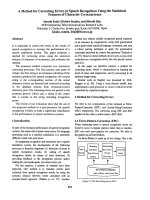
Design
Before we start building the application, we'll spend some time planning what
we'll build. This is a fairly simple application, but it serves to illustrate how ArcGIS
Desktop and ArcGIS Server can be easily integrated using the ArcGIS REST API.
In this application, we'll build an ArcGIS Python Toolbox that serves as a container
for a single tool called USGSDownload. The USGSDownload tool will use the Python
requests, JavaScript Object Notation (JSON), and ArcPy da modules to request realtime wildfire data from a USGS map service. The response from the map service will
contain information including the location of the fire, the name of the fire, and some
additional information that will then be written to a local geodatabase.
[2]
Chapter 1
The communication between the ArcGIS Desktop Python Toolbox and the ArcGIS
Server map service will be accomplished through the ArcGIS REST API and the
Python language.
Let's get started and build the application.
[3]
Extracting Real-Time Wildfire Data from ArcGIS Server with the ArcGIS REST API
Creating the ArcGIS Desktop Python
Toolbox
There are two ways to create toolboxes in ArcGIS: script tools in custom toolboxes
and script tools in Python toolboxes. Python toolboxes encapsulate everything in one
place: parameters, validation code, and source code. This is not the case with custom
toolboxes, which are created using a wizard and a separate script that processes the
business logic.
A Python Toolbox functions like any other toolbox in ArcToolbox, but it is created
entirely in Python and has a file extension of .pyt. It is created programmatically
as a class named Toolbox. In this section, you will learn how to create a Python
Toolbox and add a tool. You'll only create the basic structure of the toolbox and tool
that will ultimately connect to an ArcGIS Server map service containing the wildfire
data. In a later section, you'll complete the functionality of the tool by adding code
that connects to the map service, downloads the current data, and inserts it into a
feature class. Take a look at the following steps:
1. Open ArcCatalog: You can create a Python Toolbox in a folder by rightclicking on the Folder and navigating to New | Python Toolbox. In
ArcCatalog, there is a folder called Toolboxes, and inside it, there is a My
Toolboxes folder, as shown in the following screenshot. Right-click on this
folder and navigate to New | Python Toolbox.
[4]
Chapter 1
2. The name of the toolbox is controlled by the filename. Name the toolbox
InsertWildfires.pyt.
3. The Python Toolbox file (.pyt) can be edited in any text or code editor. By
default, the code will open in Notepad. However, you will want to use a
more advanced Python development environment, such as PyScripter, IDLE,
and so on. You can change this by setting the default editor for your script
by navigating to Geoprocessing | Geoprocessing Options and going to
the Editor section. In the following screenshot, you'll notice that I have set
my editor to PyScripter, which is my preferred environment. You may want
to change this to IDLE or whichever development environment you are
currently using.
[5]
Extracting Real-Time Wildfire Data from ArcGIS Server with the ArcGIS REST API
4. For example, to find the path to the executable for the IDLE development
environment, you can navigate to Start | All Programs | ArcGIS | Python
2.7 | IDLE. Right-click on IDLE and select Properties to display the
properties window. Inside the Target textbox, you should see a path to the
executable, as shown in the following screenshot. You will want to copy and
paste only the actual path starting with C:\Python27 and not the quotes that
surround the path.
5. Copy and paste the path into the Editor and Debugger sections inside the
Geoprocessing Options dialog box.
[6]