Using cloud computing to develop an integrated virtual system for online GIScience programs
Bạn đang xem bản rút gọn của tài liệu. Xem và tải ngay bản đầy đủ của tài liệu tại đây (890.83 KB, 15 trang )
Knowledge Management & E-Learning, Vol.8, No.4. Dec 2016
Knowledge Management & E-Learning
ISSN 2073-7904
Using cloud computing to develop an integrated virtual
system for online GIScience programs
Germana Manca
The Pennsylvania State University, PA, USA
Nigel W. Waters
The University of Calgary, Alberta, CA
Gustavo Sandi
Washington DC and Costa Rica, USA
Recommended citation:
Manca, G., Waters, N. W., & Sandi, G. (2016). Using cloud computing to
develop an integrated virtual system for online GIScience programs.
Knowledge Management & E-Learning, 8(4), 514–527.
Knowledge Management & E-Learning, 8(4), 514–527
Using cloud computing to develop an integrated virtual
system for online GIScience programs
Germana Manca*
Geoinformatics and Earth Observations Laboratory
Department of Geography and Institute for CyberScience
The Pennsylvania State University, PA, USA
E-mail:
Nigel W. Waters
Professor Emeritus of Geography
The University of Calgary, Alberta, CA
E-mail:
Gustavo Sandi
Network Consulting Services
Washington DC and Costa Rica, USA
E-mail:
*Corresponding author
Abstract: The variety of offerings of online Geographical Information Science
(GIS) programs has been extensively reported in the literature, which describes
various types of degrees and certificates offered by institutions all over the
world. Most online courses have merely focused on delivering lectures, for
which standard presentation tools such as PowerPoint are sufficient to fulfil this
task. It is imperative for GIS online courses to deliver instruction as a series of
interactive steps. This paper presents how an integrated virtual system based on
cloud computing can be developed to enhance GIS online courses, and how
such an approach provides an interactive teaching method to improve the
quality of communication between students and teachers.
Keywords: Geographical information science (GIS); GIScience; Virtual
environment; Online education; SaaS; Cloud computing
Biographical notes: Dr. Germana Manca is a faculty affiliate of the
Geoinformatics and Earth Observations Laboratory in the Department of
Geography and Institute for CyberScience at Pennsylvania State University.
She has taught several GIScience courses, and she has been involved in several
educational activities, about GIScience. She published her work in peer review
journals, such as Transactions in GIS, Applied GIS, IJGIS, Cartographica
among others.
Dr. Nigel W. Waters is a retired Full Professor from the Department of
Geography, University of Calgary, where he taught from 1975 to 2007. He was
a Full Professor in the Department of Geography and Geoinformation Science
and Director of the Center of Excellence for GIS at George Mason University,
Knowledge Management & E-Learning, 8(4), 514–527
515
Fairfax, Virginia, from 2007 to 2014. He now holds the rank of Professor
Emeritus of Geography at the University of Calgary. He has conducted and
published peer reviewed research in GIS modelling, spatial analysis, and in
medical, environmental and transportation geography applications of GIS. A
former Editor of the peer reviewed journal, Cartographica, in 2014 he received
the Award of Distinction from the Canadian Cartographic Association and in
2015 the Inaugural Award from the GIScience Study Group of the Canadian
Association of Geographers for Lifetime Achievement and GIScience
Excellence.
Gustavo Sandi has been working in the IT field since 1997 and holds M.S. and
MBA degrees. He is specialized in remote network services and he worked at
Tiempos del Mundo as IT Director and at present is employed at the
Washington Times as Senior Analyst in Washington D.C. His experience is
focused on transforming large scale and expensive projects into more
affordable and highly efficient ones.
1. Background
Many institutions in the US are offering online programs, both course-based degrees and
certificates. The range of offerings is wide and includes many GIS courses. This
explosion is due to the demand shown by the growth in the number of students enrolled
in these programs. In some instances, these students are hoping to advance their careers
and in other cases they simply desire to broaden their knowledge of GIS. For these
reasons, student enrolment in online GIS programs varies depending on the age of the
student and on employment commitments that may affect their time schedules.
The explosion of online courses is described by Wikle (2010) who depicts the
profound changes that higher education is experiencing. GIS online education has
become available at US colleges and universities through programs ranging from
traditional (face-to-face) courses to 100 percent online degrees and certificates programs
for non-traditional students. In his conclusion, Wikle refers to the GIS&T Body of
Knowledge (Waters, 2013), which provides a means for selecting online content,
ensuring that students are exposed to the breadth of knowledge needed to develop basic
GIS competencies, and assisting institutions in developing strategic plans for
implementing new programs on their campuses. A jointly promoted effort among
Canadian universities to deliver online courses has been described by Khmelevsky, Burge,
Govorov, and Hains (2011). Open education/learning is more than taking an online
course (M. A. Peters, 2009). It means fostering a new academic culture that values the
core practices of an open science and creating a new cyber infrastructure that facilitates
and seamlessly integrates all of the above procedures in open scholarly practices. Millet
et al. (2014) describe how a spatial web tool, RacerGISOnline, is an innovative approach
to integrating these tools into several courses in the marketing curriculum while avoiding
the problems that have constrained adoption.
A new online system for teaching GIS was implemented and evaluated at the
University of Georgia, US, (Rivero & Buchanan, 2014) for its potential for
implementation in other university marketing departments. These authors describe
experiences and observations from transitioning such a lab-intensive, face-to-face course
in “Advanced Geographic Information Systems” to a fully online course, using
technologies already available, such as ArcGIS, and the Learning Management System
516
G. Manca et al. (2016)
(LMS) known as elcNew. Implementation involved putting together these software
packages to provide a powerful learning environment.
A centralized ArcGIS desktop server has been described by D. Peters (2009). He
lists several choices, including the client’s use of Citrix XenApp terminal clients for
optimum computing and display performance. This framework for the learning
environment enables a more efficient and independent computing architecture
communication protocol to support communication between the server and client’s
platform. The system functions as a framework for delivering the technology.
Nevertheless, any effective way to provide “education” should exploit a diverse set of
technologies.
Course delivery technologies are analysed by Johnson, Corazzini, and Shaw
(2011). Three different online modalities of learning, including the Learning
Management System, Webinar, and Virtual Environment approaches were compared in
order to understand the students’ perception of learning. Two concurrent themes arose
from the three platforms: the technical challenges inherent in the technology and the
students’ various preferences for synchronous web-based learning. The Virtual
Environment approach emerged as the preferred distance based education methodology.
A conceptual framework in the GIS environment has been described by Schultz
(2012) for an adult, GIS online course. Essentially he described the advantages of online
courses for GIS, especially the use of a virtual GIS Server and having a professor as a
facilitator, delivering the GIS courses.
MaKinster and Trautmann (2014) refer to the concept of “evolution”, when
describing the ways in which teachers contribute to and influence the design and
direction of their professional development experiences and project outcomes. An
evolutionary approach is critical in enabling teachers and educational leaders to have
significant input into shaping the nature and direction of the project. It occurs also when
teachers work with the project team to adapt resources, develop complementary ones, and
share lessons and teaching experiences with one another using Web-based, courseware
tools. Moreover, using an integrated approach with those tools in order to deliver
courses/education and technologies, is the key to lecture development, requiring the
authors to develop a complex technological framework.
2. Methods and computational environments for GIS online courses
Any method that is applied to create a virtual educational framework for GIS online
courses requires On-demand Application Delivery Software or SaaS (Software as a
Service, the application layer of cloud computing), as well as Webinar applications and a
Virtual GIS Environment. The Learning management system known as Blackboard,
works as a collector of class materials, as a grading book and supplier of datasets, but it is
not directly involved in the learning process. SaaS is the first building block in an
integrated system. SaaS is a model where the client software is hosted by a remote server
which can be setup as a stand-alone server or a cluster of servers to support from two to
virtually an unlimited number of users. This structure uses a client-server architecture,
enabling the delivery of a very powerful learning experience that can be accessed
remotely or locally. On the Server Side, the need to have On-demand Application
Delivery software ensures that multiple users can connect to the server and share the
resource. Once this has been set up the GIS application can then be installed and run
locally in order to be shared by multiple users. Security can be guaranteed through the
SaaS environment or using a Virtual Private Network (VPN) model. The VPN is always
Knowledge Management & E-Learning, 8(4), 514–527
517
the most secure and easy method to implement, avoiding exposure on the Internet. On the
client side, the variety of plugins available for the different operating systems on the
market, such as Android, iOS, Windows, Linux and MacOS, ensures that all commonly
available hardware devices will have access to the required functionality. However, if the
server is behind a firewall then a VPN client needs to be installed.
The next building block required in the learning framework is the Webinar tool.
These tools are now attracting increased attention due to their ability to facilitate
synchronous communication in online learning environments (Wang & Hsu, 2008).
Several software programs are freely or commercially available. Among them are Joinme
(LogMeIn, Boston, MS), Anymeeting (Anymeeting, Huntington Beach, CA),
GoToWebinar (Citrix Systems, Santa Barbara, CA), Elluminate (Elluminate, Inc.,
Calgary, Canada), or Adobe Connect (Adobe Systems Inc., San Jose, CA). These
applications enable many-to-many interaction between users, have the ability to transmit
and record audio and video, offer access to the Internet, and provide opportunity for
information exchange via whiteboards and application sharing (Wang & Hsu, 2008). The
advantages of this technology include affordability, multi-level interaction (Wang & Hsu,
2008) and real time interaction between faculty and students, providing opportunities to
learn new technologies or concepts over a semester. Online discussion both synchronous
and asynchronous, typically creates an environment in which participants engage with
one another in more equitable ways by giving equal voice to those who tend to be more
reserved in face-to-face settings (Bonk, Hansen, Grabmer, Lazar & Mirabelli, 1998).
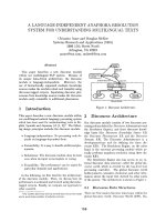
Finally, the last building block in the framework is the Virtual GIS Environment, which
is based on the technology described in Fig. 1. The client side is represented on the left of
the drawing where multiple devices can either access the servers via VPN or internally in
a Local Area Network or LAN (this might comprise a department, faculty or campus
wide environment).
Fig. 1. The Citrix Xenapp environment
518
G. Manca et al. (2016)
If students are connected remotely, they use a VPN and if they are connected
locally, they connect directly to the server. On the right side of Fig. 1, there are several
servers that perform different functions, allowing many users to be served concurrently.
The number of application servers that can be configured can range from 1 to a great
many. For a GIS application it is recommended that there should not be more than 10
users per server. A Citrix “farm” allows the control and management of interaction issues
arising from the user or student. Moreover, the shadow desktop functionality provides a
useful application to control the user session.
One of the most popular VPNs is Hamachi because of its reasonable price and full
internet support. It is very easy to manage and deploy. Citrix, on the other hand, is one of
the most expensive platforms on the market for application virtualization. Nevertheless, it
provides the best performance; it runs on top of remote services from Microsoft and
provides a better and more efficient protocol to deal with remote applications, including
the way the video is handled, which is better than its competitors.
The licensing and installation of the applications is a subject that changes from
vendor to vendor. An instructor implementing such a learning environment must check
with the vendor concerning the licensing rights and limitations, before any installation is
adopted.
3. Learning procedures in GIS online courses
This section describes the philosophy behind the GIS Virtual Environment, how it was
implemented and how it operates in online learning practice.
In order for a GIS online course to work successfully, the professor must use a
web conferencing program to invite the students to attend the class online. Ideally the
professor must have presentations pre-recorded with both audio and video. Each student
must login to a password protected, presentation website. They will then be entitled to
participate as both listener and presenter in the course conferences. In an ideal online
environment, the professor will be able to request that a student present material to the
class. The student should be able take over the instructor’s role and will only relinquish
control once his or her presentation is complete. The instructor should be able to make
PowerPoint presentations, explain exercise material and run videos in a manner that all
students will be able to participate in because all students will share a view of the
instructor’s screen.
When the professor ends the class, the session is then closed but all of the students
should have access to the session at a later time. If for some reason one of them could not
attend class that day, they can watch the recorded session at another time. Video
conferencing can be provided at any time in the session; however, it has been discovered
that this is not very practical since it will require one to one video and the screen could be
filled up with the student faces, reducing the screen size that is dedicated to displaying
the presentation.
This process improves the overall learning experience, offering the student the
ability to attend class without being physically present in a classroom, avoiding the
difficulty of transportation to the campus premises. Also it may improve the learning
experience since the student can access past material online and review the material at
any subsequent time. Once the professor dismisses the class and distributes homework
assignments, the students will have full access to the GVEnvironment, which stands for
Knowledge Management & E-Learning, 8(4), 514–527
519
GIS Virtual Environment and is a combination of technologies specifically tailored for
teaching GIS.
The following description indicates how the GVEnvironment works. First of all,
students will require a fast internet connection for the most rewarding experience. The
students also have to install two client programs that are free and can be uninstalled at
any time. One of these programs is the VPN software and the other is client software that
permits access to the GVEnvironment. The VPN software is needed to create a secure
connection between the student’s computer and the server computer while the client
software is needed to run the GIS software remotely. The installation of the client
software is completed by the student. In less than 15 minutes they can have access to the
GVEnvironment without any additional technical knowledge. Thus the complexities of
installing the GIS software on their computers is circumvented and they experience none
of the technical installation problems such as their computers being too slow, or having
insufficient memory, or that they are using a Macintosh that is not configured for ArcGIS
among other problems. All of these difficulties are avoided when using a
GVEnvironment because all of the software is pre-installed on the server.
When the user uses the server, many additional benefits are available such as
interaction in real-time between the professor and student. If the professor is online and
the student has questions or problems, the professor can oversee and control the user
session in the server and help him/her understand the problem. The professor never takes
control of the user’s computer, only the user’s session that lives in the server. This is very
important because the privacy of the student’s equipment remains intact. The professor
will have access to all the student sessions in real-time (i.e. there are no email or
blackboard downloadings) and can place homework files, assignments and even review
students’ progress on different assignments in true real time. It is the same as having the
professor physically present in the lab where a student would have raised his or her hand
to ask the professor to visit his or her station. This is something that rarely happens in the
real world, but the virtual concept allows it.
4. An experiment
An experiment was conducted to test the effectiveness of the GIS Virtual Environment.
Fig. 2 shows a screenshot of the Citrix farm with 11 users connected. In addition, it
portrays how the sessions are displayed for the professor in an environment where every
user is running the GIS software individually, and the hardware resources are assigned
based on demand using the Citrix software. In our test environment the applications
ArcGIS and Citrix Xenapp were run on a computer using an Intel i5 chip running at 2.7
Ghz with 6Gb of RAM, preferably on Solid-State Drives (SSD) but the system performs
well using regular Hard Drives with a minimum of 80Gb of memory available.
Fig. 3 shows the server performance. In our test environment it never reached its
peak even with 11 users connected concurrently; memory usage was around 50% and
processor around 6%. However, this was with the majority of users idle. When the server
was rendering or processing a map, processor use can easily reach 100%, which will be
distributed among the users who require it. Statistically it is highly improbable that all the
users at the same time will require 100% of the processor’s operating power.
Moreover, this technology allows multiple users to be connected concurrently to
different GIS programs. GVEnvironment has been tested thoroughly using the ArcGIS
software (Fig. 4) since ArcGIS is the most widely accepted software for teaching GIS.
520
G. Manca et al. (2016)
Nevertheless, the GVEnvironment can be used with other GIS software packages.
Therefore, QGIS and GRASS, which are free GIS packages, have been tested and shown
to run with no issues.
Fig. 2. Screenshot of the Citrix Farm
Fig. 3. Screenshot showing server performance
Knowledge Management & E-Learning, 8(4), 514–527
521
Fig. 4. Screenshot of the virtual desktop and ArcGIS running in the GVEnvironment
In regard to the technical performance of the system the bandwith, suggested by
Citrix literature (Ben-Chanoch, 2013), ranges between 100k and 200k (with video
applications). In our case study, we did not stream video therefore anything below the
200kbps was sufficient. The system ran with 14 users with a 5Mbps bandwidth, and
according to the rule of three, this should be more than enough to sustain all of the users
connected simultaneously. The conferencing system was hosted separately from the
Citrix server so that the two systems would not conflict.
The server provision for teaching is very different from a server used for
production. In our case, we focused on a server provision that would be able to run GIS
applications in real time without too many delays. ArcGIS for instance requires, at a
minimum, an Intel Pentium 4 at 2.2Ghz Processor with 2GB Ram for a single user, while
the setup of the Learning Server was an Intel i5 at 3.4Ghz with 6Gb Ram. This meant 3 to
4 concurrent users could run the system at close to the 100% of computing resources.
This, however, happened only when an image was rendered. Most of the time, the
processor was idle which was good for maintaining a learning environment where users
might come and go at different times during the day. Although the technology appears to
be easily supported by a standard server, the primary source of workload uncertainty was
the student’s response to the application and his or her fluency in the use of the
technology.
The GVEnvironment was tested in a class that in past years had a high level of
student appreciation and excellent evaluations. The comparison group was an
introductory GIS class, which was ideal as a test to determine if the GVEnvironment
could help the students reach the same level of knowledge as the control group. The
material was already tested by the control group students, who gave an overall positive
evaluation. In the test of the GVEnvironment some of the course content was slightly
modified to fit the display and the online sequences. Consequently, the class could be
improved only by the use of this technology. Therefore, considering that the students
have no initial knowledge of GIS, which could be misleading in regard to students
522
G. Manca et al. (2016)
already trained in GIS science, the educational benefit of an improved technology can be
highlighted.
Two classes were chosen to compare and evaluate the teaching class methods. An
online class, taught in 2014, and the control group, taught in 2013. In 2013 there were 16
students enrolled in the class, while in 2014, there were 12. The choice of these classes
was based upon the characteristics that they had in common: namely that they had used
the same version of ArcGIS and were given the same assignments. Previous classes could
not be compared, because of the different versions of the software, and consequently their
different homework assignments which were designed to be software specific. Both
classes were split into two parts: the theoretical and practical one. The practical one
proposed the application of modules and theory that had been explained during the
theoretical part. Generally, it lasted one and a half hours and the exercises were calibrated
over the acquired knowledge of the theory class. This framework worked well in both
classes, and student appreciation was shown by the unsolicited comments in the students’
emails. Moreover, the virtual interaction in an online session was both more effective and
explicit, because of the instructor’s ability to share and control the student’s desktop,
software and mouse. The instructor was able to direct the students through a sequence of
steps, retaining the student’s attention on the computing and GIS processes. Furthermore,
thanks to the Citrix farm, the instructor was able to detect any anomalies in the software
or processing being performed by each student, and was then able to restore the initial
state of the software or overcome the difficulties that the student had encountered.
Fig. 5 and Fig. 6 show a comparison between the two classes described above
based on the students’ homework performance.
Fig. 5. Results of t-test
Assessment of student results was based on the completion of nine homework
assignments during each of the courses. Each assignment was worth 50 points. The nine
learning tasks were designed to deliver GIS knowledge from a beginning up to an
intermediate level. The x axis shows the sequence of the homework, while the y axis
shows the average percentage for each of the homework assignments for the 2013 and
2014 classes. These nine assignments were designed to measure a series of increasingly
sophisticated learning tasks.
Knowledge Management & E-Learning, 8(4), 514–527
523
Fig. 6. Anova test
The online class in 2014 shows a slightly better performance as measured by the
percentage of students who reached the class goal, for each assignment during the
semester. In 2014 students reached a peak in the final assignment. In 2013 the control
group also achieved good performances too, but they did not match the online class.
Essentially this comparison is based purely on the percentage of the students that
achieved the assignment’s goal. Statistical tests of the means (t tests) and ANOVA
comparisons of the two data sets showed that in most cases there was no significant
difference between the control group and the class taught using the online technology. So
it may be concluded that the average results for the students over the nine assignments
showed that the online course had not impaired the students’ performance and the
variance in student’s performance was in some exercises reduced. More importantly the
online course provided a number of additional benefits including removal of the need for
scheduled office hours for which both instructor and students needed to be physically
present (including the provision of weekend office hours) and a reduction in unsolicited
emails from the students.
More specific improvements in the implementation of the online course can be
seen for the HM IV assignment. In this assignment the students were required to provide
a report of an industrial model that had already been developed. Thus the students were
required to investigate the materials available, and then download and execute the model.
The 2013 (control group) and the 2014 online courses differed in their execution of the
GIS code. In the online class the instructor tested the running code of each student in
his/her account, and checked to see if it worked properly. In the control group (the 2013
class), the operating systems used by the students were diverse, and the students reported
difficulties in compiling the code which could only be resolved in class while they were
physically present.
HM VIII resulted in similar performances in both classes. Again the assignment
was based on the identification of land use characteristics through GIS visualization, and
thus it required the use of only the display command. By contrast, HM VII showed the
worst performance for the online class, despite the fact that the homework was identical.
In this case, the reason for the difference in performance was that few students in the
online class received the highest grade, while some students did not complete the
assignment. Why the online students fared worse in this particular instance bears further
investigation.
524
G. Manca et al. (2016)
The control group in 2013 had scheduled office hours once a week and could, in
addition, schedule meetings at mutually convenient times. This meant that the time used
to satisfy the students’ requests and questions was considerably higher than for the online
class. The reason for the differential in the amount of student interaction is the
immediacy of help that could be provided for the online class. Quite simply put, this
immediacy was far more efficient. Students in the control group that had to wait for
scheduled office hours might not receive assistance for several days. In a busy semester, a
prompt answer solves quickly the issue and clears the way for the student to proceed with
the next steps to be undertaken in the assignment. As a result, the number of hours used
to explain to students in the control group on how to proceed in a given assignment was
increased. It may be summarized that for the control group the support was only available
during class or during office hours, while for online class, support was both personalized
and provided immediately during class hours, office hours and outside of these times as
well.
5. Discussion
Geospatial technology plays a fundamental role in training geospatial scientists for
private industry and for preparing students for academic careers. As such the
GVEnvironment framework benefits both the business and scientific communities. These
benefits can be divided into economic and educational advantages.
The economic benefits refer to the gap between the traditional classroom and the
online SaaS virtual environment models. In the traditional model, hardware and software
needs to be refreshed every 3 or 4 years. During this period of time the instructor needs to
upgrade their hardware and software once they become obsolete and no longer receive
technical support. In order to stay up to date, it is recommended by the software providers
that users purchase annual maintenance programs, assuring that the software and
hardware is current. This model requires licenses for every individual computer which
poses a 1:1 ratio for users and licenses. The SaaS model saves resources in two ways:
first, the client software can be run on aging hardware, extending the lifespan of the
equipment for possibly 3 of 4 years more. The GVEnvironment software is supported by
many systems and configurations, and does not require high capacity computers. Second,
it reduces the need for large numbers of software licenses. Since it is a client/server
model, only the cost of the server’s concurrent users will be paid. In such situations the
user:license ratio is about 3 to 1. Servers can host a number of licenses thus reducing the
number of licenses to about a third of the normal requirements.
In summary, a SaaS virtual environment for online GIS teaching has proven to be
superior in terms of the use of resources, more efficient management than a traditional
model, and less expensive in hardware and software requirements. The human resource
investment in term of technical knowledge to implement SaaS has to be carefully taken
into account. Nevertheless, when it works at full performance, the Return-On-Investment
(or ROI), can be obtained in less than one year.
Educational advantages include the increased interaction between students and
teachers in a manner which is beneficial in terms of the reduced time for responses to
student questions and more extensive visualization options (including screen and mouse
sharing). These benefits were confirmed by the unsolicited emails sent by the students to
the instructor which emphasized their appreciation of the rapid, positive feedback and
their support for receiving their instruction within the GVEnvironment.
Knowledge Management & E-Learning, 8(4), 514–527
525
Other advantages of the system include the fact that the professor fully monitors
the students and is able to observe when they are having difficulties with the assigned
exercises. The ability to observe the student’s screen is an effective method for
interacting directly with the student. It is more productive, because the professor focuses
on a specific student, until he/she understands. In a traditional classroom setting, the
professor cannot provide this as individualized attention. The GVEnvironment
application permits the professor to focus on the needs of a single student. Consequently,
each student interacts directly with the professor and the professor can then focus on
helping the specific student’s needs. Moreover, the student’s ability to use the server over
the time requested to complete their work and assignments, is a sign of their familiarity
and fluency with the online system.
6. Conclusion
SaaS technologies for the integration of software and hardware have been used and
developed in other disciplines and business environments. For instance, online editorial
systems throughout the academic world have used these technologies for a number of
years. Moreover, several commercial enterprises and public institutions have applied the
SaaS model for geospatial data, achieving impressive ROIs over short periods of time
(Smith & Turner, 2010; Maguire, Kouyoumjian, & Smith, 2008).
The same concepts and computing technologies can be applied to education. It
has been estimated that this architecture saves around 20% of yearly expenditures for
technical infrastructure. This saving has wide application since this technology can work
on almost any internet connection available. Tests have been carried out in central and
South America and the results were satisfactory. Those times when the technology
described here did not work were due to external factors that in a dedicated environment
should not occur.
While the economic and technical benefits of these technologies is now clearly
apparent, the educational advantages for geospatial education has been demonstrated by
the gains described above, that were made by students involved in the experimental use
of this infrastructure in an online course taught during 2014. Using the GVEnvironment,
students sent in unsolicited emails that described their positive feedback, regarding this
specific course and the curriculum in general.
Nevertheless it is worth re-emphasizing the following educational aspects that
have emerged from our online teaching within the GVEnvironment: first, the students’
ability to use the server over the time requested to complete their work and assignments
is a sign of their familiarity and fluency with the online system; second, the classes that
were taught using this methodology met the students’ expectations, which were: a) to be
able to work from any location; b) to be able to use a variety of platforms; c) to be able to
interface easily and constantly with their professor; and d) to be able to access online
support for technical issues; third, the instructor was able to directly monitor the work
flow of the students, to check their progress, to assess their results, to balance their
educational activities, and to measure their achievements; fourth, it is not possible to
make a comparison with existing literature on online education, because this particular
GVEvironment approach is new and has not yet been used for the teaching of geospatial
concepts. Basically the GVEnvironment overcomes the drawback of traditional in-class
teaching, thereby improving the learning process.
526
G. Manca et al. (2016)
These observations reveal how this SaaS architecture facilitates the interaction of
the instructor-student relationship in a manner which was not possible before, due to the
limitations and constraints of the former technologies. The educational outcome, obtained
using these technologies, has produced results that provided significant benefits for both
teachers and students.
Considering the outcomes, both economic and educational, this system represents
a powerful tool, not only for online teaching, which is actually well established, but also
for software interaction at the student-instructor interface.
References
Ben-Chanoch, A. (2013). Get up to speed on XenDesktop bandwith requirements.
Retrieved from />Bonk, C. J., Hansen, E. J., Grabmer, M. M., Lazar, S., & Mirabelli, C. (1998). Time to
“Connect”: synchronous and asynchronous case-based dialogue among preservice
teachers. In C. J. Bonk & K. S. King (Eds.), Electronic Collaborators: LearnerCentered Technologies for Literacy, Apprenticeship, and Disclosure (pp. 289–314).
Mahwah, NJ: Erlbaum
Johnson, C. M., Corazzini, K. N., & Shaw, R. (2011). Assessing the feasibility of using
virtual environments in distance education. Knowledge Management & E-Learning
(KM&EL), 3(1), 5–16.
Khmelevsky, Y., Burge, L., Govorov, M., & Hains, G. (2011). Distance learning
components in CS and GIS courses. In Proceedings of the 16th Western Canadian
Conference on Computing Education (WCCCE '11).
Maguire, D., Kouyoumjian, V., & Smith, R. (2008). The business benefit of GIS: An ROI
approach. RedlandS, CA: ESRI.
MaKinster, J., & Trautmann, N. (2014). The nature and design of professional
development for using geospatial technologies to teach science. In J. MaKinster, N.
Trautmann, & M. Barnett (Eds.), Teaching Science and Investigating Environmental
Issues with Geospatial technology: Designing Effective Professional Development for
Teachers (pp: 323–333). doi: 10.1007/978-90-481-3931-6_19
Miller, F. L., Mangold, W. G., Roach, J., Brockway, G., Johnston, T., Linnhoff, S.,
McNeely, S., Smith, K., & Holmes, T. (2014). RacerGISOnline: Enhancing learning
in marketing classes with web-based business GIS. Marketing Education Review,
24(1), 31–36.
Peters, D. (2009). System design strategies (26th ed): A ESRI® technical reference
document.
Redlands,
CA:
ESRI.
Retrieved
from
/>Peters, M. A. (2009). Open education and the open science economy. Yearbook of the
National Society for the Study of Education, 108(2), 203–225. doi: 10.1111/j.17447984.2009.01169.x
Rivero, R. G., & Buchanan, M. F. (2014). Designing and implementing an online
technology course: An advanced geographic information systems (GIS) online course.
In Proceedings of the INTED 2014 (pp. 6505–6512).
Schultz, R. B. (2012). A critical examination of the teaching methodologies pertaining to
distance learning in geographic education: Andragogy in an adult online certificate
program. Review of International Geographical Education Online, 2(1), 45–60.
Smith, R., & Turner, J. (2010). ROI handbook for geospatial network infrastructure and
management
solutions.
GE
Digital
Energy.
Retrieved
from
Knowledge Management & E-Learning, 8(4), 514–527
527
/>Wang, S. K., & Hsu, H. Y. (2008). Use of the webinar tool (Elluminate) to support
training: The effects of webinar-learning implementation from student-trainers'
perspective. Journal of Online Interactive Learning, 7(3), 175–194.
Waters, N. W. (2013). The geographic information science body of knowledge 2.0:
Toward a new federation of GIS knowledge. In O. Arnold, W. Spickermann, N.
Spyratos, & Y. Tanaka (Eds.), Webble Technology (pp. 129–142). Springer-Verlag
Berlin Heidelberg.
Wikle, T. A. (2010). Planning considerations for online certificates and degrees in GIS.
URISA Journal, 22(1), 21–30.