Tài liệu APPLICATION OF REMOTE SENSING IN:" FOREST SECTOR OF VIETNAM" docx
Bạn đang xem bản rút gọn của tài liệu. Xem và tải ngay bản đầy đủ của tài liệu tại đây (1011.66 KB, 31 trang )
APPLICATION OF REMOTE SENSING IN
APPLICATION OF REMOTE SENSING IN
FOREST SECTOR OF VIETNAM:
FOREST SECTOR OF VIETNAM:
Status and future direction
Status and future direction
Pham Manh Cuong (Dr. Sc.)
Pham Manh Cuong (Dr. Sc.)
FOREST DEPARTMENT (FD)
FOREST DEPARTMENT (FD)
Ministry of Agriculture and Rural Development (MARD)
Ministry of Agriculture and Rural Development (MARD)
Overview
Overview
1. Forest administration system in
Vietnam
2. Information needed for forest
management in Vietnam
3. Application of RS in forest
management in Vietnam: Past and
present
4. Future Direction
I. Forests and Forest
I. Forests and Forest
Administration System in
Administration System in
Vietnam
Vietnam
Vietnam is mostly located in the tropical region;
Vietnam is mostly located in the tropical region;
Hilly and mountainous regions account for
Hilly and mountainous regions account for
¾
¾
of
of
Vietnam
Vietnam
’
’
s total natural land;
s total natural land;
Vietnam has coastal lines more than 3,000 km
Vietnam has coastal lines more than 3,000 km
long;
long;
High diversity of forests: tropical rain forest in
High diversity of forests: tropical rain forest in
most region, sub
most region, sub
-
-
tropical forest in the north and
tropical forest in the north and
at high altitudes, mangrove forest along
at high altitudes, mangrove forest along
coastline;
coastline;
Complex terrain and diversity of forest types
Complex terrain and diversity of forest types
cause difficulty in forest management.
cause difficulty in forest management.
1.1
1.1
Forest Changes in Vietnam
Forest cover has changed dramatically and
Forest cover has changed dramatically and
dynamically over the time and space;
dynamically over the time and space;
The changes are not always in progressive,
The changes are not always in progressive,
deforestation versus reforestation;
deforestation versus reforestation;
Most residual natural forests are located in the
Most residual natural forests are located in the
mountainous regions, difficult to access;
mountainous regions, difficult to access;
1.1
1.1
Forest Changes in Vietnam
Forest cover changes
Forest cover changes
37
34,3
28,2
27,2
30
32,1
33,8
43
35,8
36,7
20
30
40
50
60
70
80
1943 1976 1980 1985 1990 1995 2000 2002 2003 2005
Population (M ill. people)
0
5
10
15
20
25
30
35
40
45
50
Forest Coverage (%)
Population Rural pop. Forest cover
Vietnam
Strengthen FM and reforestation: 14.3 mill ha in 2010
(43%) – 16.24 mill ha 2020 (47%);
In 2010: all forests are allocated to HHs & economic
entities; in 2020: permanent real forest estate
Afforestation: 1.0 mill. (2006-2010);1.5 mill ha in 2011-
2020;
Re-planning forests:
9 Production forest: 8.34 mill ha of which 4.15 ha of
forest plantations, 30% FA receives FSC
9 Protection forest: 5.68 mill ha
9 Special-use forest: 2.16 mill ha
Wood production: 20-24 mill m3/year; wood and furniture
processing: $7.8 mill ha
MARD vs. MONRE
Functional agencies inside MARD:
9 Forest Department (FD): National Forest
Management, NFIA Program
9 Forest Protection Department (FPD): Protection
forest, special-use forest, Annual forest statistics
9 Forest Inventory and Planning Institute (FIPI)
1.3
1.3 Forest Administration System in Vietnam
II. Information needed for forest
II. Information needed for forest
management
management
2.1 Demand for information on forest
management
2.1 Demand for information on forest
management
Forests quantity: types, area;
Forest quality: % crown canopy, Height,
DBH, estimated timber volume, forest
structure and forest species composition;
Distribution & location, accessibility;
Forest function and environmental and
economic values;
Forest changes and driving forces;
Relationship between forest ecosystem and
other environmental factors – silvicultural
practices;
2.2 Current Information Flows
Forest Department: overall forest related
data from sub-FDs, FPD and FIPI;
Forest Protection Department:
information about forest law enforcement,
annual forest monitoring and statistical data,
mostly focuses on protection and special-
use forest;
Forest Inventory and Planning Institute:
National forest inventory and assessment,
every 5 year – FIPI’s database.
2.3 Issues and Challenges
Lack of close coordination: data
discrepancies & data sharing;
Insufficient information: incomplete and
outdated;
Large geographical extend and difficult to
access (physical and political aspects).
Conventional techniques: time-consuming
and costly;
Insufficient capacity: in collecting,
analyzing, synthesizing and reporting
information, especially at local levels;
Expensive spatial data (maps and high
resolution remote sensing imagery.
III. Application of remote sensing
III. Application of remote sensing
technology in forestry sector of
technology in forestry sector of
Vietnam: Past and present
Vietnam: Past and present
1960s – 1970s: application of aerial photographs on
establishment of forest cover maps and forest planning
maps for some State Forest Enterprises (SFE) in the
North;
1980 – 1990: starting utilization of satellite images from
former Soviet Union and US (Landsat) to make forest
cover maps at regional level. UNDP-FAO VIE 79/014
project to strengthening cpacity for forest inventory
including application of remote sesing imagery;
1991 – 1995: conducted 1st cycle of NFI with the use of
Landsat TM to make forest cover maps at provincial
levels 1/250,000 and forest cover change detection;
Most human resources and application of RS have
concentrated in FIPI;
3.1 In the past
1996 – 2000: conducted 2nd cycle of NFI with the use of
SPOT 1,2,3 to make forest cover maps at provincial
levels 1/100,000 and forest cover change detection for
the entire country. Implementation of the tropical Forest
Information System Project funded by JICA in
collaboration with JAFTA, in which Landsat TM images
were used to creat forest maps at scale of 1/250,000 with
the support of digital classification methods;
2001-2005: conducted 3rd cycle of NFI with the use of
Landsat ETM to make forest cover maps at provincial
levels 1/100,000 and forest cover change detection for
the entire country. Application of very HR images (SPOT
5, IKONOS, QuickBird) to establish forest maps at scale
1/10,000 and forest management planning for SFEs;
Most human resources and application of RS have
concentrated in FIPI;
3.1 In the past
Most human resources and application of RS
have concentrated in FIPI;
Mainly visual interpretation (harcopy, on-screen
digitizing);
Quality was not satisfied the decision-makers and
not every sufficient for policy formulation
processes.
3.1 In the past
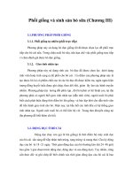
Mô tả mẫu trên ảnh (Landsat TM)
Ngày chụp: 17 - 10 - 2001
TT rừng: Rừng kín thường xanh lá rộng
Địa điểm: Kôn Hà Nừng - Gia Lai
Độ cao: 1.480 m
Mô tả: màu nâu đỏ thẫm, đồng đều, mịn
Vị trí phân bố: cách xa khu dân cư và đường
chính.
Mô tả ngoại nghiệp:
TT rừng: closed evergreen broadleaved
forest (IIIA3)
Địa điểm: Liên hiệpKônHàNừng
Độ tàn che: 0,8
Tổ thành: Sến, Hoàng đàn, Giổi, Re,
Thông nàng
Các thông số cơ bản: H = 19m, G =
19m
2
,
D = 27 cm, M = 200 - 230 m
3
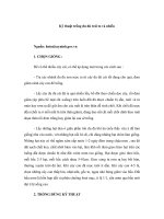
Land-cover map derived from
Landsat ETM+
Land-cover map derived from
QuickBird image
2006-2010: is now implementing 4th cycle
of NFI with the use of SPOT 5 to make
forest cover maps at provincial levels
1/25,000 – 1/50,000 for the entire country;
Forest Fire Forecasting by using MODIS at
FPD;
3.2 At present
IV.
IV.
Application of RS in Forest
Application of RS in Forest
Sector: Future direction
Sector: Future direction
Government has paid great attention in
environmental magement, in general, and in
forest protection, in particular;
National forest & rural development programs
(661, HEPR, land allocation, etc.): monitoring
and evaluation;
Multilateral Environmental Agreements (MEAs):
CBD, UNFFC, CITES, UNCCD, etc.;
4.1 Demands and Legal Supports
4.1 Demands and Legal Supports
Laws: land Law 2003, NLUI every 5 year; NFIA
every 5 years;
MARD: approved the project entitled
“Application and development of IT in forest
sector 2006-2010” and requested FD to improve
the application of IT in forest protection
MARD & FAO have submitted a project
proposal for strengthening capacity of NFI with
financial support from Japanese and Italian
Governments
4.1 Demands and Legal Supports
4.1 Demands and Legal Supports
Application of very high resolution satellite
images (SPOT 5, ALOS, IKONOS, QuickBird,
etc.) in land use/forest cover mapping, forest
planning, forest assessment and forestland
allocation, FLEGT at micro level;
Widenning the application: FIPI + Sub-FIPIs,
FD, FPD, FSIV;
Strengthening capacity of key Institutions in
application of RS in MARD
Strengthening the cooperation: governmental
agencies (MONRE), NGOs and international
organizations.
4.2 Improvement in deriving information
4.2 Improvement in deriving information