Encyclopedia of geology, five volume set, volume 1 5 (encyclopedia of geology series) ( PDFDrive ) 2277
Bạn đang xem bản rút gọn của tài liệu. Xem và tải ngay bản đầy đủ của tài liệu tại đây (53.82 KB, 1 trang )
434 REMOTE SENSING/Passive Sensors
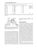
Table 1 Comparison of spectral bands of TM/ETMỵ, ASTER, and SPOT
Sensor systems
Terra 1 ASTER
Spectral
region
Band
Spectral
range (mm)
Spatial
resolution
(m)
SWIR
TIR
4
5
6
7
8
9
10
11
12
13
14
0.52
0.63
0.78
0.78
0.60
0.69
0.86
0.86
1.60 1.70
2.145 2.185
2.185
2.235
2.295
2.360
8.125
8.475
8.925
10.25
10.95
2.225
2.285
2.365
2.430
8.475
8.825
9.275
10.95
11.65
Spatial
resolution
(m)
Band
Spectral
range (mm)
1
2
3
4
ETM+ Pan
0.45
0.52
0.63
0.76
0.52
30
5
7
1.55 1.75
2.08 2.35
30
90
6
10.4 12.5
TM
120
VNIR
1
2
3N
3B
SPOT 1 3 HRV, SPOT 4 HRVI,
SPOT 5 HRG
Landsat 3 7 TM/ETMỵ
15
0.53
0.60
0.69
0.90
0.90
Band
Spectral
range (mm)
Spatial
resolution
(m)
30
15
1
2
3
Pan
0.50 0.59
20
0.61 0.68
0.79 0.89
SPOT 1 3:
10
0.51 0.73
SPOT 4:
10
0.61 0.68
SPOT 5:
2.5 5
0.48 0.71
4
1.58 1.75
20
Band 4 is only in SPOT 4 HRVI (High
Resolution Visible Infrared) and
SPOT 5 HRG (High Resolution
Geometric)
ETM+ 60
Table 2 Some satellite high resolution broadband sensor systems
Spatial resolution (m)
Spectral range (mm)
Pan
MS
0.45 0.53
0.52 0.61
0.64 0.72
0.77 0.88
0.45 0.52
0.52 0.60
0.63 0.69
0.76 0.89
0.45 0.52
0.52 0.60
0.625 0.695
0.76 0.90
0.45 0.52
0.52 0.60
0.625 0.695
0.76 0.90
Satellite
Launch time and Status
Pan
MS
Ikonos 2
24 Sept. 1999
In operation
1
4
0.45 0.90
QuickBird
18 Oct. 2001
In operation
1
4
0.45 0.90
Orbview 3
26 June 2003
In operation
1
4
0.45 0.90
Orbview 4
Failed at launch in Sept. 2001
1
4
The MSS with 4 spectral bands on board Landsat
1–3 is a classical example of a mechanical scanner. It
is a one-way scanner that scans in one direction of
mirror rotation only, and with an empty return run.
Such a design makes compensation of the Earth’s
Hyp
8
0.45 0.90
Hyp
0.45 2.50 200 bands
rotation easier, as the Earth rotates a fixed distance
along the swath direction for each scanning cycle.
However, the inactive return would waste valuable
time for imaging, resulting in a shorter dwelling time
in the active runs and thus reduce spatial resolution.