Ebook Computing in geographic information systems: Part 1
Bạn đang xem bản rút gọn của tài liệu. Xem và tải ngay bản đầy đủ của tài liệu tại đây (3.98 MB, 147 trang )
Computing in Geographic
Information Systems
Computing in Geographic
Information Systems
Narayan Panigrahi
Boca Raton London New York
CRC Press is an imprint of the
Taylor & Francis Group, an informa business
CRC Press
Taylor & Francis Group
6000 Broken Sound Parkway NW, Suite 300
Boca Raton, FL 33487-2742
© 2014 by Taylor & Francis Group, LLC
CRC Press is an imprint of Taylor & Francis Group, an Informa business
No claim to original U.S. Government works
Version Date: 20140415
International Standard Book Number-13: 978-1-4822-2316-3 (eBook - PDF)
This book contains information obtained from authentic and highly regarded sources. Reasonable efforts
have been made to publish reliable data and information, but the author and publisher cannot assume
responsibility for the validity of all materials or the consequences of their use. The authors and publishers
have attempted to trace the copyright holders of all material reproduced in this publication and apologize to
copyright holders if permission to publish in this form has not been obtained. If any copyright material has
not been acknowledged please write and let us know so we may rectify in any future reprint.
Except as permitted under U.S. Copyright Law, no part of this book may be reprinted, reproduced, transmitted, or utilized in any form by any electronic, mechanical, or other means, now known or hereafter invented,
including photocopying, microfilming, and recording, or in any information storage or retrieval system,
without written permission from the publishers.
For permission to photocopy or use material electronically from this work, please access www.copyright.
com ( or contact the Copyright Clearance Center, Inc. (CCC), 222 Rosewood
Drive, Danvers, MA 01923, 978-750-8400. CCC is a not-for-profit organization that provides licenses and
registration for a variety of users. For organizations that have been granted a photocopy license by the CCC,
a separate system of payment has been arranged.
Trademark Notice: Product or corporate names may be trademarks or registered trademarks, and are used
only for identification and explanation without intent to infringe.
Visit the Taylor & Francis Web site at
and the CRC Press Web site at
This book is dedicated to the loving memory of my
parents
Shri Raghu Nath Panigrahi and Smt Yasoda Panigrahi
Village Pallipadnapur, District Ganjam, State Odisha
of India
who brought me up with dedication and placed
education second to none despite their modest means
Contents
List of Figures
xv
List of Tables
xix
Introduction
xxi
Preface
xxiii
Acknowledgments
xxv
Author Bio
xxvii
1 Introduction
1.1
Definitions and Different Perspectives of GIS . . . . . .
1.1.1
Input Domain of GIS . . . . . . . . . . . . . . .
1.1.2
Functional Profiling of GIS . . . . . . . . . . . .
1.1.3
Output Profiling of GIS . . . . . . . . . . . . . .
1.1.4
Information Architecture of GIS . . . . . . . . .
1.1.4.1 Different Architectural Views of GIS .
1.1.5
GIS as a Platform for Multi-Sensor Data Fusion
1.1.6
GIS as a Platform for Scientific Visualization . .
1.2
Computational Aspects of GIS . . . . . . . . . . . . . .
1.3
Computing Algorithms in GIS . . . . . . . . . . . . . .
1.4
Purpose of the Book . . . . . . . . . . . . . . . . . . . .
1.5
Organization of the Book . . . . . . . . . . . . . . . . .
1.6
Summary . . . . . . . . . . . . . . . . . . . . . . . . . .
.
.
.
.
.
.
.
.
.
.
.
.
.
.
.
.
.
.
.
.
.
.
.
.
.
.
1
2
2
3
7
7
8
11
12
13
14
14
17
18
2 Computational Geodesy
2.1
Definition of Geodesy . . . . . . . . . . . . . . . . . .
2.2
Mathematical Models of Earth . . . . . . . . . . . . .
2.2.1
Physical Surface of Earth . . . . . . . . . . . .
2.2.2
The Reference Geoid . . . . . . . . . . . . . .
2.2.3
The Reference Ellipsoid . . . . . . . . . . . . .
2.3
Geometry of Ellipse and Ellipsoid . . . . . . . . . . . .
2.3.1
Relation between ‘e’ and ‘f’ . . . . . . . . . . .
2.4
Computing Radius of Curvature . . . . . . . . . . . .
2.4.1
Radius of Curvature at Prime Vertical Section
.
.
.
.
.
.
.
.
.
.
.
.
.
.
.
.
.
.
19
19
20
21
21
22
22
25
25
27
.
.
.
.
.
.
.
.
.
vii
viii
Contents
2.5
.
.
.
.
.
.
.
.
.
.
.
.
.
.
28
28
28
29
29
29
30
31
31
32
32
33
33
34
3 Reference Systems and Coordinate Transformations
3.1
Definition of Reference System . . . . . . . . . . . . . . . .
3.2
Classification of Reference Systems . . . . . . . . . . . . . .
3.3
Datum and Coordinate System . . . . . . . . . . . . . . . .
3.4
Attachment of Datum to the Real World . . . . . . . . . . .
3.5
Different Coordinate Systems Used in GIS . . . . . . . . . .
3.5.1
The Rectangular Coordinate System . . . . . . . .
3.5.2
The Spherical Coordinate System . . . . . . . . . .
3.5.3
The Cylindrical Coordinate System . . . . . . . . .
3.5.4
The Polar and Log-Polar Coordinate System . . . .
3.5.5
Earth-Centered Earth-Fixed (ECEF) Coordinate
System . . . . . . . . . . . . . . . . . . . . . . . . .
3.5.6
Inertial Terrestrial Reference Frame (ITRF) . . . .
3.5.7
Celestial Coordinate System . . . . . . . . . . . . .
3.5.8
Concept of GRID, UTM, Mercator’s GRID and Military GRID . . . . . . . . . . . . . . . . . . . . . . .
3.6
Shape of Earth . . . . . . . . . . . . . . . . . . . . . . . . .
3.6.1
Latitude and Longitude . . . . . . . . . . . . . . . .
3.6.2
Latitude . . . . . . . . . . . . . . . . . . . . . . . .
3.6.3
Longitude . . . . . . . . . . . . . . . . . . . . . . .
3.7
Coordinate Transformations . . . . . . . . . . . . . . . . . .
3.7.1
2D Coordinate Transformations . . . . . . . . . . .
3.7.2
3D Coordinate Transformations . . . . . . . . . . .
3.8
Datum Transformation . . . . . . . . . . . . . . . . . . . . .
3.8.1
Helmert Transformation . . . . . . . . . . . . . . .
3.8.2
Molodenskey Transformation . . . . . . . . . . . . .
3.9
Usage of Coordinate Systems . . . . . . . . . . . . . . . . .
3.10 Summary . . . . . . . . . . . . . . . . . . . . . . . . . . . .
35
35
36
37
37
38
39
39
40
42
2.6
2.7
2.8
Concept of Latitude . . . . . . . . . . . . . . .
2.5.1
Modified Definition of Latitude . . . .
2.5.2
Geodetic Latitude . . . . . . . . . . . .
2.5.3
Geocentric Latitude . . . . . . . . . . .
2.5.4
Spherical Latitude . . . . . . . . . . . .
2.5.5
Reduced Latitude . . . . . . . . . . . .
2.5.6
Rectifying Latitude . . . . . . . . . . .
2.5.7
Authalic Latitude . . . . . . . . . . . .
2.5.8
Conformal Latitude . . . . . . . . . . .
2.5.9
Isometric Latitude . . . . . . . . . . . .
2.5.10 Astronomical Latitude . . . . . . . . .
Applications of Geodesy . . . . . . . . . . . . .
The Indian Geodetic Reference System (IGRS)
Summary . . . . . . . . . . . . . . . . . . . . .
.
.
.
.
.
.
.
.
.
.
.
.
.
.
.
.
.
.
.
.
.
.
.
.
.
.
.
.
.
.
.
.
.
.
.
.
.
.
.
.
.
.
.
.
.
.
.
.
.
.
.
.
.
.
.
.
.
.
.
.
.
.
.
.
.
.
.
.
.
.
.
.
.
.
.
.
.
.
.
.
.
.
.
.
43
45
46
48
50
50
51
51
52
53
54
55
57
58
58
59
Contents
ix
4 Basics of Map Projection
4.1
What Is Map Projection? Why Is It Necessary? . . . . . . .
4.2
Mathematical Definition of Map Projection . . . . . . . . .
4.3
Process Flow of Map Projection . . . . . . . . . . . . . . .
4.4
Azimuthal Map Projection . . . . . . . . . . . . . . . . . .
4.4.1
Special Cases of Azimuthal Projection . . . . . . . .
4.4.2
Inverse Azimuthal Projection . . . . . . . . . . . . .
4.5
Cylindrical Map Projection . . . . . . . . . . . . . . . . . .
4.5.1
Special Cases of Cylindrical Projection . . . . . . .
4.5.1.1 Gnomonic Projection . . . . . . . . . . . .
4.5.1.2 Stereographic Projection . . . . . . . . . .
4.5.1.3 Orthographic Projection . . . . . . . . . .
4.5.2
Inverse Transformation . . . . . . . . . . . . . . . .
4.6
Conical Map Projection . . . . . . . . . . . . . . . . . . . .
4.7
Classification of Map Projections . . . . . . . . . . . . . . .
4.7.1
Classification Based on the Cartographic Quantity
Preserved . . . . . . . . . . . . . . . . . . . . . . . .
4.7.2
Classification Based on the Position of the Viewer .
4.7.3
Classification Based on Method of Construction . .
4.7.4
Classification Based on Developable Map Surface .
4.7.5
Classification Based on the Point of Contact . . . .
4.8
Application of Map Projections . . . . . . . . . . . . . . . .
4.8.1
Cylindrical Projections . . . . . . . . . . . . . . . .
4.8.1.1
Universal Transverse Mercator (UTM) . .
4.8.1.2
Transverse Mercator projection . . . . .
4.8.1.3
Equidistant Cylindrical Projection . . . .
4.8.1.4 Pseudo-Cylindrical Projection . . . . . . .
4.8.2
Conic Map Projection . . . . . . . . . . . . . . . . .
4.8.2.1 Lambert’s Conformal Conic . . . . . . . .
4.8.2.2 Simple Conic Projection . . . . . . . . . .
4.8.2.3 Albers Equal Area Projection . . . . . . .
4.8.2.4 Polyconic Projection . . . . . . . . . . . .
4.8.3
Azimuthal Projections . . . . . . . . . . . . . . . .
4.9
Summary . . . . . . . . . . . . . . . . . . . . . . . . . . . .
61
61
62
63
64
66
67
68
69
70
70
70
70
71
74
5 Algorithms for Rectification of Geometric Distortions
5.1
Sources of Geometric Distortion . . . . . . . . . . . .
5.1.1
Definition and Terminologies . . . . . . . . . .
5.1.2
Steps in Image Registration . . . . . . . . . .
5.2
Algorithms for Satellite Image Registration . . . . . .
5.2.1
Polynomial Affine Transformation (PAT) . . .
5.2.2
Similarity Transformation . . . . . . . . . . .
5.3
Scale Invariant Feature Transform (SIFT)
. . . . . .
5.3.1
Detection of Scale-Space Extrema . . . . . . .
5.3.2
Local Extrema Detection . . . . . . . . . . . .
87
88
89
89
91
91
92
93
94
94
.
.
.
.
.
.
.
.
.
.
.
.
.
.
.
.
.
.
.
.
.
.
.
.
.
.
.
75
76
77
78
79
80
80
80
81
81
81
82
82
82
82
82
83
83
x
Contents
5.4
5.5
5.6
5.7
5.3.3
Accurate Key Point Localization . . . . .
5.3.4
Eliminating Edge Responses . . . . . . .
Fourier Mellin Transform . . . . . . . . . . . . .
5.4.1
The Log-Polar Transformation Algorithm
Multiresolution Image Analysis . . . . . . . . . .
Applications of Image Registration . . . . . . . .
Summary . . . . . . . . . . . . . . . . . . . . . .
.
.
.
.
.
.
.
.
.
.
.
.
.
.
.
.
.
.
.
.
.
.
.
.
.
.
.
.
.
.
.
.
.
.
.
6 Differential Geometric Principles and Operators
6.1
Gradient (First Derivative) . . . . . . . . . . . . . . . . .
6.2
Concept of Curvature . . . . . . . . . . . . . . . . . . . .
6.3
Hessian: The Second Order Derivative . . . . . . . . . . .
6.4
Gaussian Curvature . . . . . . . . . . . . . . . . . . . . .
6.5
Mean Curvature . . . . . . . . . . . . . . . . . . . . . . .
6.6
The Laplacian . . . . . . . . . . . . . . . . . . . . . . . .
6.7
Properties of Gaussian, Hessian and Difference of Gaussian
6.7.1
Gaussian Function . . . . . . . . . . . . . . . . . .
6.7.2
Hessian Function . . . . . . . . . . . . . . . . . .
6.7.3
Difference of Gaussian . . . . . . . . . . . . . . . .
6.8
Summary . . . . . . . . . . . . . . . . . . . . . . . . . . .
7 Computational Geometry and Its Application to GIS
7.1
Introduction . . . . . . . . . . . . . . . . . . . . . . . .
7.2
Definitions . . . . . . . . . . . . . . . . . . . . . . . .
7.2.1
Triangulation and Partitioning . . . . . . . . .
7.2.2
Convex Hull . . . . . . . . . . . . . . . . . . .
7.2.3
Voronoi Diagram and Delaunay Triangulation
7.3
Geometric Computational Techniques . . . . . . . . .
7.4
Triangulation of Simple Polygons . . . . . . . . . . . .
7.4.1
Theory of Polygon Triangulation . . . . . . . .
7.4.2
Dual Tree . . . . . . . . . . . . . . . . . . . .
7.4.3
Polygon Triangulation . . . . . . . . . . . . . .
7.4.3.1 Order Type . . . . . . . . . . . . . .
7.4.4
Line Segment Intersection . . . . . . . . . . .
7.4.5
Finding Diagonals in a Polygon . . . . . . . .
7.4.6
Naive Triangulation Algorithm . . . . . . . . .
7.5
Convex Hulls in Two Dimensions . . . . . . . . . . . .
7.5.1
Graham’s Scan: . . . . . . . . . . . . . . . . .
7.5.1.1 Steps of Graham’s Scan . . . . . . .
7.6
Divide and Conquer Algorithm . . . . . . . . . . . . .
7.6.1
Divide and Conquer Convex Hull . . . . . . .
7.6.1.1 Lower Tangent . . . . . . . . . . . .
7.6.2
Quick Hull . . . . . . . . . . . . . . . . . . . .
7.7
Voronoi Diagrams . . . . . . . . . . . . . . . . . . . .
7.7.1
Properties of Voronoi Diagrams . . . . . . . .
.
.
.
.
.
.
.
.
.
.
.
.
.
.
.
.
.
.
.
.
.
.
.
.
.
.
.
.
.
.
.
.
.
.
.
.
.
.
.
.
.
.
.
.
.
.
.
.
.
.
.
.
.
95
98
100
101
102
103
105
.
.
.
.
107
107
108
110
111
112
114
114
115
115
116
117
.
.
.
.
.
.
.
.
.
.
.
.
.
.
.
.
.
.
.
.
.
.
.
119
119
120
120
121
121
122
123
124
126
127
127
129
131
132
133
133
134
135
136
136
137
139
140
.
.
.
.
.
.
Contents
7.8
7.9
7.10
7.11
7.12
xi
Delaunay Triangulation . . . . . . . . . . . . . . . . . . . .
7.8.1
Properties of Delaunay Triangulation . . . . . . . .
Delaunay Triangulation: Randomized Incremental Algorithm
7.9.1
Incremental Update . . . . . . . . . . . . . . . . . .
Delaunay Triangulations and Convex Hulls . . . . . . . . .
Applications of Voronoi Diagram and Delaunay Triangulation
7.11.1 Applications of Voronoi Diagrams . . . . . . . . . .
Summary . . . . . . . . . . . . . . . . . . . . . . . . . . . .
141
141
143
143
147
151
152
152
8 Spatial Interpolation Techniques
8.1
Non-Geostatistical Interpolators . . . . . . . . . .
8.1.1
Nearest Neighbours . . . . . . . . . . . . .
8.1.2
Triangular Irregular Network . . . . . . . .
8.1.3
Natural Neighbours . . . . . . . . . . . . .
8.1.4
Inverse Distance Weighting . . . . . . . . .
8.1.5
Regression Models . . . . . . . . . . . . . .
8.1.6
Trend Surface Analysis . . . . . . . . . . .
8.1.7
Splines and Local Trend Surfaces . . . . .
8.1.8
Thin Plate Splines . . . . . . . . . . . . . .
8.1.9
Classification Methods . . . . . . . . . . .
8.1.10 Regression Tree . . . . . . . . . . . . . . .
8.1.11 Fourier series . . . . . . . . . . . . . . . . .
8.1.12 Lapse Rate . . . . . . . . . . . . . . . . . .
8.2
Geostatistics . . . . . . . . . . . . . . . . . . . . .
8.2.1
Introduction of Geostatistics . . . . . . . .
8.2.2
Semivariance and Variogram . . . . . . . .
8.2.3
Kriging Estimator . . . . . . . . . . . . . .
8.2.4
Simple Kriging . . . . . . . . . . . . . . . .
8.2.5
Ordinary Kriging . . . . . . . . . . . . . .
8.2.6
Kriging with a Trend . . . . . . . . . . . .
8.2.7
Block Kriging . . . . . . . . . . . . . . . .
8.2.8
Factorial Kriging . . . . . . . . . . . . . .
8.2.9
Dual Kriging . . . . . . . . . . . . . . . . .
8.2.10 Simple Kriging with Varying Local Means
8.2.11 Kriging with an External Drift . . . . . . .
8.2.12 Cokriging . . . . . . . . . . . . . . . . . . .
8.3
Summary . . . . . . . . . . . . . . . . . . . . . . .
.
.
.
.
.
.
.
.
.
.
.
.
.
.
.
.
.
.
.
.
.
.
.
.
.
.
.
.
.
.
.
.
.
.
.
.
.
.
.
.
.
.
.
.
.
.
.
.
.
.
.
.
.
.
.
.
.
.
.
.
.
.
.
.
.
.
.
.
.
.
.
.
.
.
.
.
.
.
.
.
.
.
.
.
.
.
.
.
.
.
.
.
.
.
.
.
.
.
.
.
.
.
.
.
.
.
.
.
.
.
.
.
.
.
.
.
.
.
.
.
.
.
.
.
.
.
.
.
.
.
.
.
.
.
.
155
156
156
156
156
158
159
159
159
159
160
160
160
161
161
161
162
163
164
165
165
165
165
166
166
166
166
167
9 Spatial Statistical Methods
9.1
Definition of Statistics . . . . . . .
9.2
Spatial Statistics . . . . . . . . . .
9.3
Classification of Statistical Methods
9.3.1
Descriptive Statistics . . .
9.4
Role of Statistics in GIS . . . . . .
9.5
Descriptive Statistical Methods . .
.
.
.
.
.
.
.
.
.
.
.
.
.
.
.
.
.
.
.
.
.
.
.
.
.
.
.
.
.
.
169
169
170
171
171
173
174
. . .
. . .
. .
. . .
. . .
. . .
.
.
.
.
.
.
.
.
.
.
.
.
.
.
.
.
.
.
.
.
.
.
.
.
.
.
.
.
.
.
.
.
.
.
.
.
xii
Contents
9.5.1
9.5.2
9.5.3
9.5.4
9.5.5
9.6
9.7
9.8
9.9
Mean . . . . . . . . . . . . . . . . . .
Median . . . . . . . . . . . . . . . . .
Mode . . . . . . . . . . . . . . . . . .
Variance . . . . . . . . . . . . . . . .
Standard Deviation . . . . . . . . . .
9.5.5.1 Best Estimation of Standard
9.5.5.2 Mean Deviation . . . . . . .
9.5.6
Standard Error . . . . . . . . . . . .
9.5.7
Range . . . . . . . . . . . . . . . . . .
9.5.8
Skewness . . . . . . . . . . . . . . . .
9.5.9
Kurtosis . . . . . . . . . . . . . . . .
Inferential Statistics . . . . . . . . . . . . . .
9.6.1
Correlation Coefficient (R) . . . . . .
9.6.2
Moran’s Index, or Moran’s I . . . . .
9.6.3
Geary’s C . . . . . . . . . . . . . . .
9.6.4
General G Statistic . . . . . . . . . .
Point Pattern Analysis in GIS . . . . . . . . .
Applications of Spatial Statistical Methods .
Summary . . . . . . . . . . . . . . . . . . . .
. . . . . .
. . . . . .
. . . . . .
. . . . . .
. . . . . .
Deviation
. . . . . .
. . . . . .
. . . . . .
. . . . . .
. . . . . .
. . . . . .
. . . . . .
. . . . . .
. . . . . .
. . . . . .
. . . . . .
. . . . . .
. . . . . .
.
.
.
.
.
.
.
.
.
.
.
.
.
.
.
.
.
.
.
.
.
.
.
.
.
.
.
.
.
.
.
.
.
.
.
.
.
.
174
175
175
175
175
176
176
176
176
177
177
178
178
179
180
181
182
183
183
10 An Introduction to Bathymetry
185
10.1 Introduction and Definition . . . . . . . . . . . . . . . . . . 185
10.2 Bathymetric Techniques . . . . . . . . . . . . . . . . . . . . 185
10.3 Difference between Bathymetry and Topography . . . . . . 187
10.4 Bathymetric Data Survey and Modeling . . . . . . . . . . . 188
10.4.1 Bathymetric Data Models . . . . . . . . . . . . . . 188
10.4.1.1 S-57 . . . . . . . . . . . . . . . . . . . . . 189
10.4.1.2 S-52 . . . . . . . . . . . . . . . . . . . . . 189
10.4.1.3 S-63 . . . . . . . . . . . . . . . . . . . . . 190
10.4.1.4 S-100 . . . . . . . . . . . . . . . . . . . . . 190
10.5 Representation of Sea Depth and Sounding . . . . . . . . . 190
10.5.1 Nautical Chart . . . . . . . . . . . . . . . . . . . . . 191
10.5.2 Details on Nautical Chart . . . . . . . . . . . . . . 191
10.6 Map Projection, Datum and Coordinate Systems Used in
Bathymetry . . . . . . . . . . . . . . . . . . . . . . . . . . . 194
10.7 Application of Bathymetry Used in Preparation of bENCs . 194
10.8 Differences between ENC, SENC, and RENC . . . . . . . . 195
10.8.1 ENC - Electronic Navigational Chart . . . . . . . . 196
10.8.2 SENC - System Electronic Navigational Chart . . . 196
10.8.3 RENC - Regional ENC Coordinating Center . . . . 196
10.9 Differences between a Map and a Chart . . . . . . . . . . . 196
10.10 Summary . . . . . . . . . . . . . . . . . . . . . . . . . . . . 199
Contents
xiii
11 Spatial Analysis of Bathymetric Data and Sea GIS
11.1 Difference between a Nautical Chart and an Electronic Chart
11.1.1 Sailing Charts . . . . . . . . . . . . . . . . . . . . .
11.1.2 General Charts . . . . . . . . . . . . . . . . . . . .
11.1.3 Coastal Charts . . . . . . . . . . . . . . . . . . . . .
11.1.4 Harbour Charts . . . . . . . . . . . . . . . . . . . .
11.2 Projection Used in ENC . . . . . . . . . . . . . . . . . . . .
11.2.1 Some Characteristics of a Mercator Projection . . .
11.2.2 Scale of ENC . . . . . . . . . . . . . . . . . . . . . .
11.3 Elements in a Bathymetric Chart . . . . . . . . . . . . . . .
11.4 Summary . . . . . . . . . . . . . . . . . . . . . . . . . . . .
201
202
202
203
203
203
203
203
204
205
207
12 Measurements and Analysis Using GIS
12.1 Location . . . . . . . . . . . . . . . . . . . . . . . . . . . . .
12.2 Distance Measure . . . . . . . . . . . . . . . . . . . . . . . .
12.2.1 Linear Distance . . . . . . . . . . . . . . . . . . . .
12.2.2 Geodetic Distance . . . . . . . . . . . . . . . . . . .
12.2.3 Manhattan Distance . . . . . . . . . . . . . . . . . .
12.2.4 Haversine Formula . . . . . . . . . . . . . . . . . . .
12.2.4.1 Haversine Formula for Calculating Distance
12.2.5 Vincenty’s Formula . . . . . . . . . . . . . . . . . .
12.3 Shortest Distance . . . . . . . . . . . . . . . . . . . . . . . .
12.3.1 Dijkstra’s Algorithm . . . . . . . . . . . . . . . . .
12.3.1.1 Intuition behind Dijkstra’s Algorithm . . .
12.3.1.2 Idea of Dijkstra’s Algorithm . . . . . . . .
12.3.1.3 Pseudo Code for Dijkstra’s Algorithm . .
12.3.1.4 Analysis of the Time Complexity . . . . .
12.3.2 Direction . . . . . . . . . . . . . . . . . . . . . . . .
12.3.2.1 Azimuth . . . . . . . . . . . . . . . . . . .
12.3.2.2 Bearings . . . . . . . . . . . . . . . . . . .
12.3.2.3 North, Magnetic North and Grid North . .
12.4 Area . . . . . . . . . . . . . . . . . . . . . . . . . . . . . . .
12.4.1 Planimetric Area . . . . . . . . . . . . . . . . . . .
12.5 Computation of Volume . . . . . . . . . . . . . . . . . . . .
12.6 Computation of Slope and Aspect . . . . . . . . . . . . . .
12.7 Curvature . . . . . . . . . . . . . . . . . . . . . . . . . . . .
12.8 Hill Shade Analysis . . . . . . . . . . . . . . . . . . . . . . .
12.9 Visibility Analysis . . . . . . . . . . . . . . . . . . . . . . .
12.9.1 Line of Sight Analysis . . . . . . . . . . . . . . . . .
12.10 Flood Inundation Analysis . . . . . . . . . . . . . . . . . . .
12.11 Overlay Analysis . . . . . . . . . . . . . . . . . . . . . . . .
12.11.1 Discrete Time Overlay Analysis . . . . . . . . . . .
12.11.2 Continuous Time Overlay Analysis . . . . . . . . .
12.12 Summary . . . . . . . . . . . . . . . . . . . . . . . . . . . .
209
209
211
211
211
212
212
213
214
214
215
215
215
216
217
217
217
218
218
219
220
221
222
224
224
224
224
228
230
230
231
231
xiv
Contents
13 Appendix A
233
13.1 Reference Ellipsoids . . . . . . . . . . . . . . . . . . . . . . 233
13.2 Geodetic Datum Transformation Parameters (Local to WGS84) . . . . . . . . . . . . . . . . . . . . . . . . . . . . . . . . 234
13.3 Additional Figures, Charts and Maps . . . . . . . . . . . . 235
13.4 Line of Sight . . . . . . . . . . . . . . . . . . . . . . . . . . 239
14 Appendix B
14.1 Definitions . . . . . . . . . . . . . . . . . . . .
14.1.1 Earth Sciences . . . . . . . . . . . . . .
14.1.2 Geodesy . . . . . . . . . . . . . . . . .
14.1.3 Geography . . . . . . . . . . . . . . . .
14.1.4 Bathymetry . . . . . . . . . . . . . . .
14.1.5 Hypsometry . . . . . . . . . . . . . . .
14.1.6 Hydrography . . . . . . . . . . . . . . .
14.1.7 Terrain . . . . . . . . . . . . . . . . . .
14.1.8 Contour, Isoline, Isopleths . . . . . . .
14.1.9 LIDAR . . . . . . . . . . . . . . . . . .
14.1.10 RADAR . . . . . . . . . . . . . . . . .
14.1.11 Remote Sensing . . . . . . . . . . . . .
14.1.12 Global Positioning System . . . . . . .
14.1.13 Principal Component Analysis . . . . .
14.1.14 Affine Transformation . . . . . . . . . .
14.1.15 Image Registration . . . . . . . . . . .
14.1.16 Photogrammetry . . . . . . . . . . . . .
14.1.17 Universal Transverse Mercator (UTM)
.
.
.
.
.
.
.
.
.
.
.
.
.
.
.
.
.
.
.
.
.
.
.
.
.
.
.
.
.
.
.
.
.
.
.
.
.
.
.
.
.
.
.
.
.
.
.
.
.
.
.
.
.
.
.
.
.
.
.
.
.
.
.
.
.
.
.
.
.
.
.
.
.
.
.
.
.
.
.
.
.
.
.
.
.
.
.
.
.
.
.
.
.
.
.
.
.
.
.
.
.
.
.
.
.
.
.
.
.
.
.
.
.
.
.
.
.
.
.
.
.
.
.
.
.
.
241
241
241
241
241
241
242
242
242
242
243
243
243
243
244
244
244
245
245
15 Glossary of GIS Terms
247
Bibliography
255
Index
259
List of Figures
1.1
1.2
1.3
1.4
Block diagram depicting the macro GIS functions . . . . . .
Multi-tier architecture in GIS . . . . . . . . . . . . . . . . .
Collaborative diagram depicting various contributing branches
of science and technology; GIS as a platform for scientific computing . . . . . . . . . . . . . . . . . . . . . . . . . . . . . .
Organization of chapters . . . . . . . . . . . . . . . . . . . .
12
17
2.1
2.2
2.3
2.4
Separation of geoid and ellipsoid undulation
Auxilary circle, the 2D projected ellipsoid .
Geodetic and geocentric latitude . . . . . . .
Reduced latitude . . . . . . . . . . . . . . .
.
.
.
.
21
24
29
30
3.1
3.2
3.3
3.4
3.5
Spherical coordinate system . . . . . . . . . . . . . . . . . .
Cylindrical coordinate system . . . . . . . . . . . . . . . . .
Polar coordinate system . . . . . . . . . . . . . . . . . . . .
Celestial coordinate system . . . . . . . . . . . . . . . . . .
Celestial coordinate of constallation Sirus defined by RA and
declination . . . . . . . . . . . . . . . . . . . . . . . . . . . .
Universal transverse Mercator grid system . . . . . . . . . .
Transformation of the datum surface . . . . . . . . . . . . .
41
42
44
47
3.6
3.7
4.1
4.2
4.3
4.4
4.5
4.6
4.7
4.8
4.9
4.10
.
.
.
.
.
.
.
.
.
.
.
.
.
.
.
.
.
.
.
.
.
.
.
.
.
.
.
.
.
.
.
.
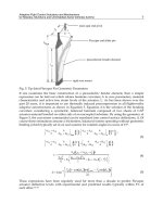
Map projection, the mapping of Earth coordinates to map
coordinates . . . . . . . . . . . . . . . . . . . . . . . . . . .
Process flow of map projection . . . . . . . . . . . . . . . . .
Schematic of azimuthal map projection . . . . . . . . . . . .
Schematic of cylindrical map projection . . . . . . . . . . .
Schematic of conical map projection . . . . . . . . . . . . .
Flattened cone after cutting along a central meridian . . . .
Map projections based on the position of the viewer . . . . .
Geometry of map developable surfaces: (A) planar, (B) cylindrical, (C) conical placed tangent to the datum surface . .
Geometry of map developable surfaces: (A) planar, (B) cylindrical, (C) conical placed secant to the datum surface . . . .
Geometry of the map projections depending upon the orientation of the map surface with the datum surface: (A) normal,
(B) transverse, (C) oblique . . . . . . . . . . . . . . . . . . .
6
9
48
49
56
63
64
65
69
72
72
77
78
79
79
xv
xvi
Computing in Geographic Information Systems
5.1
5.2
5.3
5.4
5.5
6.1
Steps of computing key points from satellite image using scale
invariant feature transform (SIFT), detection of key points
form image using DOG and maximization rule. . . . . . . .
Gaussian blurred image pyramid, depicting the scale space of
an image . . . . . . . . . . . . . . . . . . . . . . . . . . . . .
Detection of keypoint from image using DoG and maximization rule . . . . . . . . . . . . . . . . . . . . . . . . . . . . .
Example of registration of satellite image pair using Log-Polar
transformation: (a) base image, (b) image with geometric error, (c) image (b) registered and resampled with respect to
image (a) . . . . . . . . . . . . . . . . . . . . . . . . . . . .
Satellite images: (a) base image, (b) image with geometric
distortion, (c) image, (b) registered with respect to image (a),
(d) final registered image (b) . . . . . . . . . . . . . . . . .
96
97
98
99
100
Edge surface with Gaussian curvature K = 0, λ1 =
0 and λ2 < 0. The principal eigenvalues are directed in orthogonal directions. . . . . . . . . . . . . . . . . . . . . . .
Saddle surface with Gaussian curvature K < 0, λ1 <
0 and λ2 > 0 The, principal eigenvalues directed in orthogonal directions of the dominant curvatures . . . . . . . . .
Blob-like surface with Gaussian curvature K > 0, λ1 <
0 and λ2 < 0, a convex surface . . . . . . . . . . . . . . . .
113
7.1
7.2
7.3
7.4
7.5
7.6
7.7
7.8
7.9
7.10
7.11
7.12
7.13
7.14
7.15
7.16
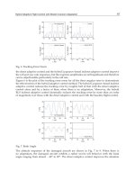
Polygonal curves . . . . . . . . . .
Existence of a diagonal . . . . . . .
Dual graph triangulation . . . . . .
Types of line segment intersections
Diagonal test in a polygon . . . . .
Graham’s scan . . . . . . . . . . . .
Push and pop operation . . . . . .
Computing the lower tangent . . .
QuickHulls initial quadrilateral . .
QuickHull elimination procedure .
Voronoi diagram . . . . . . . . . .
Delaunay triangulation . . . . . . .
Basic triangulation changes . . . .
Point insertion . . . . . . . . . . . .
Delaunay triangulations and convex
Planes and circles . . . . . . . . . .
.
.
.
.
.
.
.
.
.
.
.
.
.
.
.
.
124
125
126
130
132
133
135
137
138
139
140
142
145
145
148
150
8.1
8.2
Variogram with range, nugget and sill . . . . . . . . . . . . .
Commonly used variogram models: (a) spherical; (b) exponential; (c) linear; and (d) Gaussian . . . . . . . . . . . . .
162
6.2
6.3
. . .
. . .
. . .
. . .
. . .
. . .
. . .
. . .
. . .
. . .
. . .
. . .
. . .
. . .
hulls
. . .
.
.
.
.
.
.
.
.
.
.
.
.
.
.
.
.
.
.
.
.
.
.
.
.
.
.
.
.
.
.
.
.
.
.
.
.
.
.
.
.
.
.
.
.
.
.
.
.
.
.
.
.
.
.
.
.
.
.
.
.
.
.
.
.
.
.
.
.
.
.
.
.
.
.
.
.
.
.
.
.
.
.
.
.
.
.
.
.
.
.
.
.
.
.
.
.
.
.
.
.
.
.
.
.
.
.
.
.
.
.
.
.
.
.
.
.
.
.
.
.
.
.
.
.
.
.
.
.
.
.
.
.
.
.
.
.
.
.
.
.
.
.
.
.
.
.
.
.
.
.
.
.
.
.
.
.
.
.
.
.
112
113
163
List of Figures
10.1
10.2
10.3
10.4
10.5
10.6
12.1
12.2
12.3
12.4
12.5
12.6
12.7
13.1
(a) Ray diagram of working sonar; (b) multi-beam sonar working principle . . . . . . . . . . . . . . . . . . . . . . . . . . .
New York Harbor nautical chart . . . . . . . . . . . . . . . .
Chart colours and representation . . . . . . . . . . . . . . .
Topobathymetry production of bENC . . . . . . . . . . . . .
Example of a map . . . . . . . . . . . . . . . . . . . . . . . .
Example of a chart . . . . . . . . . . . . . . . . . . . . . . .
(a) Geodesic distance; (b) Manhattan distance . . . . . . . .
Planimetric area of a triangle . . . . . . . . . . . . . . . . .
Computation of volume using contour data . . . . . . . . . .
Slope computed as the ratio of rise over run in terrain surface
DEM grid with cardinal designator for the height . . . . . .
Line of sight between the observer and various points of the
terrain . . . . . . . . . . . . . . . . . . . . . . . . . . . . . .
Line of sight between the observer and ship at sea . . . . . .
xvii
186
192
193
195
198
199
213
220
221
222
223
225
227
Satellite image of Chilka Lake in the state of Odisha in India
depicting a land, sea and lake with its vector map draped on it 235
13.2 A contour map covering a portion of land and sea . . . . . . 235
13.3 Topobathymetry surface with vector data of topography and
S-57 bathymetry data of sea . . . . . . . . . . . . . . . . . . 236
13.4 Topobathymetry surface depicting the sea contours and
sounding measures of the sea depth in fathoms . . . . . . . 236
13.5 An instance of a flythrough visualization of a DEM draped
with raster map . . . . . . . . . . . . . . . . . . . . . . . . . 237
13.6 3D perspective visualization of an undulated terrain with sun
shaded relief map draped on it . . . . . . . . . . . . . . . . . 237
13.7 Colour-coded satellite image of an undulated terrain surface
depicting relief . . . . . . . . . . . . . . . . . . . . . . . . . . 238
13.8 Computation of communication line of sight between transmitter and receiver with the corresponding terrain profile
along the LOS . . . . . . . . . . . . . . . . . . . . . . . . . . 239
13.9 Computation of line-of-sight fan 360 degrees around the observer . . . . . . . . . . . . . . . . . . . . . . . . . . . . . . . 240
13.10 Line of sight between observer and the target the visible portion is depicted in green and invisible in red . . . . . . . . . 240
List of Tables
1.1
1.2
Input Domain of a GIS . . . . . . . . . . . . . . . . . . . . .
Computing Algorithms and Their Usage in GIS . . . . . . .
4
15
4.1
4.2
Criteria of Projecting Earth Surface and Classes of Map Projections . . . . . . . . . . . . . . . . . . . . . . . . . . . . . .
Applications of Map Projections . . . . . . . . . . . . . . . .
75
84
5.1
Applications of Image Registration Algorithms . . . . . . . .
104
8.1
The Spatial Interpolation Methods Considered in This Chapter . . . . . . . . . . . . . . . . . . . . . . . . . . . . . . . .
157
9.1
Comparison of Univariate and Bivariate Data . . . . . . . .
172
10.1
Differences between a Chart and a Map . . . . . . . . . . .
197
12.1
Spatial Location Measures and Their Applications
. . . . .
210
13.1
Important Reference Parameters of Ellipsoids in Use . . . .
233
xix
Introduction
The progress of GIS (Geographic Information System) over the past two
decades has been phenomenal. The quantity and quality of research literature contributed, new applications developed and systems engineered using
GIS are indicators of its growing popularity among researchers, industry and
the user community. Though GIS derives its acronym from Geographic Information System, it has emerged as a platform for computing spatio-temporal
data obtained through a heterogeneous array of sensors from Land-Air-Sea
in a continuous time frame. Therefore, GIS can easily be connoted as SpatioTemporal Information (STI) system.
The capability of continuous acquisition of high spatial and high spectral
data has resulted in the availability of a large volume of spatial data. This has
led to the design, analysis, development and optimization of new algorithms
for extraction of spatio-temporal patterns from the data. The trend analysis in spatial data repository has led to the development of data analytics.
The progress in the design of new computing techniques to analyze, visualize,
quantify and measure spatial objects using high volume spatial data has led
to research in the development of robust and optimized algorithms in GIS.
The collaborative nature of GIS has borrowed modeling techniques, scientific principles and algorithms from different fields of science and technology.
Principles of geodesy, geography, geomatics, geometry, cartography, statistics, remote sensing, and digital image processing (DIP) have immensely contributed to its growth. In this book I have attempted to compile the essential
computing principles required for the development of GIS. The modeling,
mathematical transformations, algorithms and computation techniques which
form the basis of GIS are discussed. Each chapter gives the underlying computing principle in the form of CDF (Concept-Definition-Formula). The overall
arrangement of the chapters follows the principle of IPO (Input-ProcessingOutput) of spatial data by GIS.
This book is intended to encourage the scientific thoughts of students,
researchers and users by explaining the mathematical principles of GIS.
xxi
Preface
Each time I wanted to experiment and analyze the spatial data presented to
me, I was confronted with many queries such as: Which GIS function will
be suitable to read the spatial data format? Which set of functions will be
suitable for the analysis? How to visualize and analyze the resulted outputs?
Which COTS GIS has all the related functions to meaningfully read, analyze,
visualize and measure the spatio-temporal event in the data?
Even if I were to select a COTS GIS system which is most suitable to answer all these queries, the cumbersome process of fetching the COTS GIS along
with its high cost and strict licensing policy discourages me from procuring
it. That made me a very poor user of COTS GIS and associated tools.
But the quest to analyze, visualize, estimate and measure spatial information has led me to search for the mathematical methods, formulae, algorithms
that can accomplish the task. To visualize terrain as it is through modeling of
spatial data has always challenged the computing skills that I acquired during
my academic and professional career.
The alternatives left are to experiment with the growing list of open source
GIS tools available or to design and develop a GIS software. Compelled by
all these circumstances I developed a set of GIS tools for visualization and
analysis ab initio.
The design and development of GIS functions need deeper understanding
of the algorithms and mathematical methods inherent in the process. The first
principle approach of development has its own merit and challenges. This has
led me to delve into the mathematical aspects of geodesy, cartography, map
projection, spatial interpolation, spatial statistics, coordinate transformation
etc. This book is the outcome of the associated scientific computations along
with the applications of computational geometry, differential geometry and
affine geometry in GIS.
Putting all these scientific principles together I came up with a new definition. GIS is a collaborative platform for visualization and analysis of spatiotemporal data using computing methods of geodesy, photogrammetry, cartography, computer science, computational geometry, affine geometry, differential
geometry, spatial statistics, spatial interpolation, remote sensing, and digital
image processing.
This book is intended for students, researchers and professionals engaged
in analysis, visualization and estimation of spatio-temporal data, objects and
events.
xxiii