Báo cáo " Characteristics of Quaternary sedimentary facies in relation to water bearing capacity of aquifers and aquicludes in the Red River Delta, Vietnam " ppt
Bạn đang xem bản rút gọn của tài liệu. Xem và tải ngay bản đầy đủ của tài liệu tại đây (700.73 KB, 7 trang )
VNUJournalofScience,EarthSciences23(2007)170‐176
170
CharacteristicsofQuaternarysedimentaryfacies
inrelationtowaterbearingcapacityofaquifers
andaquicludesintheRedRiverDelta,Vietnam
NguyenThanhLan*,TranNghi,DangMai,DinhXuanThanh
CollegeofScience,VNU
Received07March2007
Abstract.There are five Quaternary sedimentary sequences in the Red River Delta, Vietnam. The
formingofeachsequenceisrelated to transgressionandregressionphases.Thesequences, which
was formed in transgression period, composed mainly of fine grained size leading to the water
bearingcapacityisvery
lowandplaysaroleasaquicludes.Besides,inthesefinegrainsizelayers,
thecontentsofarsenicandironarehigh,especiallyindarkclay,siltyclayrichinorganic material
ofswampfaciesandbrown,darkbrown clay of flood facies sothattheyarestated as a sourceof
arsenic contamination in the groundwater. For the sequences formed in regression period
composed mainly of gravel, cobbles, pebbles, and coarse sand of fluvial, river channel facies are
goodaquif e r s .Theseaquif e r s arethemainsupplysourcesforhumanactivitiesintheRedRiverDelta.
Keywords:Aquiclude;Aquifer;RedRiverDelta;Sedimentaryfacies.
1.Introduction
*
LikemanycitiesandprovincesofVietnam,
the provinces in the Red River Delta receive
watersupplyfromgroundwaterinQuaternary
sediments. The characteristics, potential and
variation trend of this water resource depends
much on the distribution of sedimentary facies
in the stratigraphic column. The depositional
environment and material composition
express
different paleogeographic environments such
as marine, continental environment or
transitionalenvironment.IntheRedRiverDelta
area, the facial association rule is examined in
_______
*
Correspondingauthor.Tel.:84‐4‐5587059.
E‐mail:
three spatial directions: vertical, perpendicular
andparallelwiththepresentcoastline.
2. Characteristics of Quaternary sedimentary
sequences
In Quaternary, the Red River Delta
experienced glaciation stages: Gunz, Mindel,
Riss,Wurm1,Wurm2,andcorrespondingwith
them transgression phases. These stages have
left behind 5 sedimentary sequences
corresponding with 5 sedimentary
cycles in
Quaternary each began. The coarse grain size
sediments were formed in regressions phase
and fine grain size sediments were formed in
transgression phases. Accordingly, the
NguyenThanhLan etal./VNUJournalofScience,EarthSciences 23(2007)170‐176
171
Quaternary sediments in the Red River Delta
are identified by the following sedimentary
sequences:
‐ The first sequence was formed in Early
Pleistocene and corresponded with Le Chi
Formation. The sediments of this sequence are
composed mainly of cobbles, pebbles, and
coarsesandofriverchannelenvironmentinthe
lower part
and medium sand, silt and clay of
floodplainintheupperpart.
‐ The second sequence that corresponds
with the second depositional cycle, formed in
Middle to Lowermost Late Pleistocene. This
sequence corresponds with Hanoi Formation
and consisting of cobbles, pebbles, gravel of
proluvialandmountainousriverbedfacies.
‐ The
third sequence corresponds with the
third depositional cycle and was formed in
Uppermost of Late Pleistocene. It corresponds
with Vinh Phuc Formation which contains
coarse to medium grained sand of plain river
bed facies and chan gin g up war ds into finer
sediments co nsisting mainly silty clay mixed
with fine sand of flood plain
facies and clay of
lagoonalfacies.
‐ The fourth sequence was formed in
Lowermost of Late Pleistocene to Early‐
Middle Holocene, corresponding with the
fourth depositional cycle of Hai Hung
Formation,composedofgreenishgrayclayand
peatoflagoonandcoastalswampfacies.
‐ The fifth sequence was formed in
Late
Holocene and composed of sand, silt and clay
of deltaic facies, corresponding with the fifth
depositionalcycleofThaiBinhFormation.
In spatial distribution,the sediments of the
first and second sequences are rather
widespreadintheplain.Thethirdsequencehas
a continuous change of facies from sand, silt
and clay of alluvial facies to clayey silt mixed
with sand of deltaic facies and silty clay of
lagoonal facies in the central part passing into
siltyclayofflood plain, oxbow,coastalswamp
andpeatfaciesinthedirectionfromtheplainto
the modern coastline. The fourth sequence
consistsofswampclay,lagoonalclayandpeat.
Inthedirectiontowardsthecenteroftheplain,
eachofthesesequencesappearsmoreandmore
particular facies that forms a quite complete
faciesassociation.Thus,intheevolutionprocess
0
10
20
30
40
50
60
70
80
90
100
110
120
130
140
Depth
(m)
BH59-64
605
BH-11
105
To Lich
River
Red River
BH2-HN
156
BH3-HN
180
BH4-HN
ta.amQ
tb
2
3
am lbQ hh
2
1-2
amQ vp
III
2
aQlc
I
Nvb
2
2
~
.
~
.
~
.
~
~
.
~
.
~
~
.
~
.
~
.
~
.
~
.
~
~
.
~
.
~
.
~
~
.
~
.
~
.
~
~
.
~
.
~
.
~
~
.
~
.
~
.
~
~
.
~
.
~
~
.
~
.
~
.
~~
.
~
.
~
.
~
~
.
~
.
~
.
~
~
.
~
.
~
.
~
~
.
~
.
~
.
~
~
.
~
.
~
.
~
~
.
~
.
~
.
~
~
.
~
.
~
.
~
~
.
~
.
~
.
~
~
.
~
.
~
.
~
~
.
~
.
~
.
~
~
.
~
.
~
.
~
~
.
~
.
~
.
~
~
.
~
.
~
.
~
~
.
~
.
~
.
~
~
.
~
.
~
~
.
~
.
~
~
.
~
.
~
.
~
~
.
~
.
~
.
~
~
.
~
.
~
.
~
~
.
~
.
~
.
~
~
.
~
.
~
.
~
~
.
~
.
~
.
~
~
.
~
.
~
.
~
~
.
~
.
~
.
~
~
.
~
.
~
.
~
~
.
~
.
~
.
~
~
.
~
.
~
.
~
~
.
~
.
~
.
~
~
.
~
.
~
.
~
~
.
~
.
~
.
~
~
.
~
.
~
.
~
~
.
~
.
~
.
~
~
.
~
.
~
.
~
~
.
~
.
~
.
~
~
.
~
.
~
.
~
~
.
~
.
~
.
~
~
.
~
.
~
.
~
~
.
~
.
~
.
~
~
.
~
.
~
.
~
~
.
~
.
~
.
~
~
.
~
.
~
.
~
~
.
~
.
~
.
~
~
.
~
.
~
.
~
~
.
~
.
~
.
~
~
.
~
.
~
.
~
.
~
.
~
.
~
.
~
.
~
.
~
.
~
.
~
.
~
.
~
.
~
.
~
.
~
.
~
.
~
.
~
.
~
.
~
.
~
.
~
.
~
.
~
.
~
.
~
.
~
.
~
.
~
.
~
.
aQ b
IV
3
apQ hn
1
2-3a
a.amQ
tb
2
3
a.am Q
tb
2
3
a.amQ
tb
2
3
aQ
tb
2
3
amQ
vp
1
3a
a,am Q
vp
1
3a
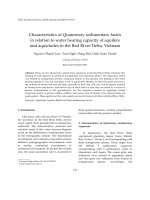
Fig.1.QuaternarysedimentaryfacialcrosssectionintheRedRiverDelta[5].
NguyenThanhLan etal./VNUJournalofScience,EarthSciences 23(2007)170‐176
172
of the Quaternary sediments in the Red River
Delta,thereisaclearchangeofsedimentaryfacies
associations and corresponding with changing
in lithological composition and sedimentation
parameters such as: Md, Ro, So, Me,
permeabilityandpaleogeographicenvironments
in each period, which represent the water
bearing properties as well as
the quality of the
groundwater in the region. Therefore, the
important aquiferswithgoodqualit ycorrespon ds
with the coarse grained sediment layers of
alluvialandproluvialfacies(formedinthefirst
stage of each cycle), while the aquicludes are
fine sediments of deltaic, coastal swamp and
marinefacies(formedinthe
finalstageofeach
cycle). Based on this point of view, the
Quaternarysedim e ntsintheRedRiverDeltacan
be divided into the following hydrogeological
units: Holocene aquifer (Qh); Pleistocene
aquifer(Qp),Pleistocene‐Holoceneaquiclude,
Middle‐LatePleistoceneaquiclude.
3. Facial characteristics and water bearing
properties of the aquifers
and aquicludes in
theRedRiverDelta
3.1.Holoceneaquifer(Qh)
The Holocene aquifer is distributed at a
shallow depth where the water fluctuates in a
widerangefrom2‐4mupto36m, withthickness
increasing towards the center of plain. It is
composedofsand,silt,clay
ofalluvialfaciesof
Thai Binh Formation (Fig. 2) in the upper part
and lens of sand, silt, clay of Hai Hung
Formation in the lower part which are low
water bearing capacity layers. The particle size
distribution is: gravel 2%, sand 30‐85%, silt‐
clay15‐70%.Thesediment
indicatorsare:Md=
0.02‐0.11mm,So=1.21‐2.85,pH
sediments
=5.5‐8.2,
Eh
sediments
=‐5÷‐10mV.Inthislayer,thespecific
capacityofwellsisverylowandchangingfrom
2to3l/sm.
Especially, the groundwater regime is
affected directly by river and rain water
percolating through the overlying Thai Binh
Formation. The fluctuation amplitude of the
waterleveldecreases
withthedistancefromthe
river. Therefore, this aquifer is mainly
rechargedbytherain waterand surfacewater,
especially in some big rivers in the Red River
system. The groundwater is discharged mainly
through the evaporation process and
percolation to the Pleistocene aquifer. Water
qualityofthislayerisfresh,
softtoslightlyhard
withtotaldissolvedsolid(TDS)content<1mg/l
and bicarbonate calcium, bicarbonate sodium
calcium type. According to the results of
chemical analysis, the groundwater in the
Holocene aquifer has a
r
Na
/r
Cl
ratio of 1.56, a
hardness of 2‐9, a pH of 7.5, a TDS content of
1.2‐11.7g/l,inparticularitsironcontentreaches
1.24to33.5mg/l.
Fig.2.Laminatedfinesandinterclatedwithsiltof
alluvialfaciesofHoloceneaquiferinVP2borehole,
Hanoiarea(6.9‐7.2mdepth).CourtesyofESTNV‐2
Project(EnvironmentalScienceandTechnologyin
NorthernVietnam)supportedbySDCand
implementedbyCETASDandEawag.
3.2.Pleistoceneaquifer(Qp)
ThePleistoceneaquiferiswidelydistributed
in the Red River Delta and is overlain by the
younger sedimentary layer which is the
Pleistocene‐Holoceneaquiclude.Thesediments
of this layer consist of 3 formations: Le Chi
Formation, Hanoi Formation, and Vinh Phuc
Formation (Fig. 3‐5). These
sediments are
intercalatedbyfinesedimentsofclayeymudof
lagoon environment of Le Chi Formation, the
NguyenThanhLan etal./VNUJournalofScience,EarthSciences 23(2007)170‐176
173
tidalflatsiltysandandlagoonalclayandlenses
of lacustrine clay of Ha noi Formation, the
laterizedlagoonalclayofVinhPhucFormation,
the alternating greenish gray clay and peat
bearing swamp clayey mud of Hanoi
Formation which serve as an aquiclude and
aquitard. The particle size distribution is as
follows: cobbles, pebbles, gravel 2.5%, sand
56.7%,silt‐clay40.8%.Thesedimentindicators
areMd=0.25,So=3.2,pH
sediments
=6.7.However,
these layers are very thin and were formed as
small lenses due to erosion and sheet washing
during regression phases before the formation
of the overlying coarse sediments. The specific
capacityofboreholesdrilledintothisaquiferis
higher than that into the Holocene aquifer (in
the
sedimentlayerofVinhPhucFormation:2‐9
l/ms, Hanoi and Le Chi formations: 26‐51 l/ms).
Thegroundwaterinthisaquiferisfresh(TDS<
lg/l),ofbicarbonatecalcium,bicarbonatesodium
‐ calcium type, with
r
Na
/r
Cl
ratio = 0.98‐5.6,
pH
water
=1.0‐8.1,TDS=0.1‐0.5g/landveryhigh
iron content (2‐25 mg/l). However, the iron
content in this aquifer is lower than that in the
Holoceneaquifer.
3.3. Uppermost of Late Pleistocene‐Holocene
aquiclude
The Holocene and Pleistocene aquifers are
separatedbythePleistoceneHoloc ene
aquiclude.
Fig.3.LatePleistocenecoarsegrainedsand
ofriverchannelfaciesinVP2borehole,Hanoiarea
(28‐28.3mdepth)CourtesyofESTNV‐2Project.
Fig.4.LatePleistocenecoarsegrainedsand,gravelof
riverchannelfaciesinVP2borehole,Hanoiarea
(39.2‐41.2mdepth).CourtesyofESTNV‐2Project.
Fig5.EarlyPleistocenepebble,cobbleoffluvialfacies
inVP2borehole,Hanoiarea(55‐57mdepth).
CourtesyofESTNV‐2Project.
The Pleistocene‐Holocene aquiclude is
composed mainly of greenish gray fine clayey
sand of lago onal and coastal swamp facies of
HaiHungFormationintheuppersequenceand
thefinesedimentsofdeltaicandmarinefaciesof
VinhPhucFormationinthelowersequence.
The sedimentof Vinh Phuc Formation was
weathered (Fig. 6) that created reddish brown
toorange.Fe
2+
/Fe
3+
cont ent equals0.1‐0.05,TOC
is changing from 0.23 to 0.26µg/g in deltaic
sediments; and Fe
2+
/Fe
3+
= 1.7, TOC = 0.54 in
NguyenThanhLan etal./VNUJournalofScience,EarthSciences 23(2007)170‐176
174
marinesediments.The
r
Na
/r
Cl
ra tio ofthislayer
is 0.66, pH
water
= 1‐8 and the water hardness is
1.5‐1.6mg/l.
ThesedimentofHaiHungFormation,which
corresponds to Early‐Middle Holocene, is
composedmainlyofsiltyclayandfinesandmixed
clayofdeltaicfacies.Thislayerischaracterized
byoxidationenvironmentthatindicatedbylow
value
ofTOCandratioofFe
2+
/Fe
3+
.
Besides, silty clay and clay rich in organic
material of swamp facies that formed in early
Flandrian transgression (10.000 to 6.000 year
BP, Fig. 7) are in high values of TOC and
Fe
2+
/Fe
3+
, which indicated for reduction
environment.Moreover,contentoftotalarsenic
in sediment of this facies are very high (6‐33.0
mg/g)[1,2,4].
Regressionphase happened afterFlandrian
transgression that formed sandy silt clay and
siltyclayofdeltaicanddarkbrownclayofriver
flood facies. The sediments
what took in dark
brownclayofriverfloodinPhapVanborehole
havecontentofarsenicreachto2‐12um/g.
The combination of them created as thick
sedimentary layer playing a role of relatively
thick aquiclude that separating the overlying
Holocene aquifer above and the Pleistocene
aquiferbelow.
ThethicknessofthePleistocene‐
Holoceneaquiclude varies from 6 m to 11.5 m.
However,duetotheactionofoldriversystems,
insomeplacesthereisnotraceofthefinegrain
sediments, but there remain only the coarse
grainedsedimentsofriverbedfacies,whichare
of high
storage and water bearing capacity.
These areʺhydrogeological windowsʺ (Fig. 8).
The hydrogeological windows are areas where
the groundwater in the Holocene aquifer is
interconnectedwiththePleistoceneaquifer.
3.4.Middle‐LowermostofLatePleistoceneaquiclude
TheupperpartoftheHanoiFormationwith
green gray to dark gray clay
and silt of lagoon
facies, lens of lacustrine clay formed during the
Middle‐LatePleistocene transgression is called
Middle‐Late Pleistocene aquiclude. However,
as it is eroded during the regression phase and
its dis tribution area is small and is associated
with silty sand of tidal flat facies and alluvial
cobbles,pebbles,
thisaquicludehassmallerextent
than the Pleistocene ~ Holocene aquiclude
above. Also for this reason, it is usually
neglectedandattributedtothelocalaquicludein
the Pleistocene aquifer. The pa rticle size
distribution is: sand: 46%, silt‐clay: 60%. The
sedimentindicatorsare:Md=0.15mm,So=
4.5,
Eh
sediments
=50mV,pH
sediments
=7.5.Ther
Na
/r
Cl
ratio
of the groundwater equals 0.8, pHwater= 7.5.
The iron content in the water is relatively high
(>10mg/l).
4.Resultsanddiscussion
The relationship between sedimentary
facies and aquifers, aquicludes is very strong.
The primary and secondary sedimentary
sequences are composed mainly of coarse‐
grained sand, cobbles and
pebbles of
mountainous river facies in the lowerpart that
is a good potential and quality layer. Besides,
the upper part of each layer was covered
mainlybysiltyclay;clayishsiltmixedfinesand
of flood and deltaic facies is a bad aquiclude.
The Pleistocene‐Holocene aquiclude, which
contained mainly
of fine grained size such as
clay, silt, silty clay, clayey silt and rich in
organic material is good regional aquiclude.
These sediments are mainly formed in
reduction environment (Fe
2+
/Fe
3+
> 1 and TOC
arehigh)andhavehighcontentoftotalarsenic.
Besides, the upper part of Holocene aquiclude
appeared brown and dark brown clay of flood
facies what are in high content of arsenic.
Arsenicabsorbedbyironhydroxidewhileiron
hydroxide absorbing by clay mineral.
Therefore, this layer
was considered as a main
source of arsenic contamination in the
groundwater.
NguyenThanhLan etal./VNUJournalofScience,EarthSciences 23(2007)170‐176
175
Fig.6.Siltyclay,clayspottedweatheringofmarinesedimentinVP1borehole,
Hanoiarea(13‐13.74mdepth).CourtesyofESTNV‐2Project.
Fig.7.Clay,siltyclayrichinorganicmaterialofswampfacies
inVP2borehole,Hanoiarea(0.95‐1.0mdepth).CourtesyofESTNV‐2Project.
Fig.8.HydrogeologicalwindowbetweenPleistoceneaquiferandHoloceneaquiferin
HanoiareaaccordingtoNguyenVanDan[3].
Acknowledgements
This paper is completed within the
framework of Fundamental Research Program
funded by Vietnam Ministry of Science and
Technology. The pictures in this paper were
published by courtesy of ESTNV‐2 Project
(Environmental Science and Technology in
Top
Botto
m
Top
Bottom
NguyenThanhLan etal./VNUJournalofScience,EarthSciences 23(2007)170‐176
176
Northern Vietnam) implemented by CETASD
andEawagunderfinancialsupportofSDC.
References
[1] M. Berg,TranHongCon, NguyenThiChuyen,
Pham Hung Viet, Arsenic contamination of
ground and drinking water in Vietnam: A
human health threat, Journal of Environmental
Science&Technology13(2001)2621.
[2] Nguyen Trong Uyen, Tran Hong Con et al.,
Actual situation of heavy metals contamination
in groundwater
of Hanoi area, VNU Journal of
Science, Natural Sciences and Technology No. 1 /
XVII(2001)32(inVietnamese).
[3] Nguyen Van Dan, Nguyen Thi Dung, Current
status of groundwater pollution in Hanoi area,
JournalofHydrogeology24(2004)18.
[4] Pham Hung Viet et al., Preliminary survey for
evaluation
of arsenic level in groundwater and
supply water in Hanoi area, in Current situation
of arsen ic pollution in Vietnam, Department of
GeologyandMineralsofVietnam,Hanoi,2005.
[5] Tran Nghi,Relationshipbetweenthelithofacies
and ground water of Quaternary sediments in
the Red River Delta, Journal of Geology 226A
(1995)11(inVietnamese).