Tài liệu Action plan for the multi-level conservation of forest wetlands in the Mekong River Delta, Vietnam pdf
Bạn đang xem bản rút gọn của tài liệu. Xem và tải ngay bản đầy đủ của tài liệu tại đây (255.11 KB, 8 trang )
International Congress on Development, Environment and Natural Resources: Multi-level and Multi-scale
Sustainability
. Cochabamba, Bolivia, 11 – 13 July, 2007
------------------------------------------------------------------------------------------------------------------------------------------
Action plan for the multi-level conservation of forest wetlands in the
Mekong River Delta, Vietnam
L.A. Tuan
1,2
, G. Wyseure
2
1
Department of Environmental and Water Resources Engineering,
College of Technology, CanTho University, CanTho, Vietnam
2
Division of Soil and Water Management, Faculty of Bioscience Engineering,
Katholieke Universiteit Leuven, Heverlee, Belgium
Keywords: Mekong, wetland, forest, water, multi-level conservation
Abstract
The Mekong River Delta in Vietnam can be considered as a large tropical wetland, in
which two typical eco-forest wetlands can be distinguished: the inland
Melaleuca forest
wetlands and the coastal mangrove forest wetlands. Their main functions are the
provision of forest commodities, the regulation of the water balance and biodiversity
conservation. However as elsewhere under human pressure their existence is under the
threat of forest fires and deforestation. Their protection requires the implementation of a
multi-level national or sub-national planning policy. This paper elaborates on a few
processes and offers a number of suggestions for a sustainable policy action plan,
which fits the objectives at national, regional and local level.
1. Introduction
In the period 1992 to 1997, the United Nations Development Programme provided a 3-
million USD grant to the Vietnamese Government for the formulation and
implementation, of a Biodiversity Action Plan (BAP). The goal of the BAP is remediation
of the threats to biodiversity caused by the 40 years of war. In 1993, the Vietnam
National Assembly approved the Law on Environment Protection and the Vietnamese
Government signed the Convention on Biological Diversity and ratified officially this
Convention in 1994. One year later, in 1995, Vietnam Prime Minister signed the BAP for
Vietnam. Under this document, Vietnam recognizes the importance of wetlands in
supporting biodiversity, and has committed itself to establish a number of protected
areas encompassing important wetlands with high biodiversity values [1].
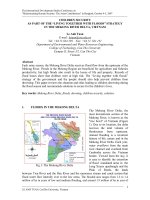
The Mekong Delta (MD) in Vietnam, located in the tropical monsoon zone, is formed by
the alluvium deposition of the Mekong River stretching from the border between
Cambodia and Vietnam to the sea (Fig. 1). The MD is four million hectares in size and
hosts 18 million inhabitants. It is the country
’s basket for agricultural, fishery and
forestry. The MD supplies more than 50 percent of the nation
’s staple food and covers
International Congress on Development, Environment and Natural Resources: Multi-level and Multi-scale
Sustainability
. Cochabamba, Bolivia, 11 – 13 July, 2007
------------------------------------------------------------------------------------------------------------------------------------------
60 percent of the total fish production. The MD is confirmed as a part of the international
biodiversity conservation Mekong basin.
Fig.1: The Mekong River Basin and Land forms of the MD in Vietnam
The main objective of this article is the presentation of the forest wetland inventory
process, applied to both the inland and coastal forests. Forest wetland inventory is
considered as the first most important step in the formulation of sustainable strategies in
wetland conservation. The inventories provide information on the type and the location
of wetland, the economic and ecological value of the wetland, and the type and
incidence of human threat [2]. They are used as basis for the formulation of
conservation priorities, the drafting of planning and management measures and
regulations, and a variety of conservation programmes.
2. Materials and Methods
There are only two seasons in the MD: the rainy and dry season. Each year, from May
to October, most of the MD receives between 1800 and 2200 mm of rainfall. At the end
of the rainy season, due to the combination of floodwater draining from the upstream
areas, the overland flood water entering from Cambodia across the Vietnam border, the
inland high rainfall and the effects of high tide from the sea, yearly between 1.2 and 1.9
million hectares of land are inundated, mainly the Northern parts of the MD known as
the LongXuyen quadrangle and the Plain of Reeds. Along the 600 km-coast, the sea
tide strongly influences the water quality by sea water intrusion. In the dry season,
about 500,000 hectares of land are affected by salinity intrusion. In addition, an area of
2-million ha is covered by acid sulphate soils.
International Congress on Development, Environment and Natural Resources: Multi-level and Multi-scale
Sustainability
. Cochabamba, Bolivia, 11 – 13 July, 2007
------------------------------------------------------------------------------------------------------------------------------------------
In the period 2001-2006 many wetlands, such as Tram Chim, Lang Sen, Ha Tien, U
Minh, Dat Mui, Lung Ngoc Hoang and others were surveyed. Parallel and for the
account of the Vietnamese Government the available literature on forest wetlands was
reviewed, and a summary made of special documents, maps, published and
unpublished data. This review was complemented with rapid in-situ wetland
assessments and interviews as to better identify the key problems with respect to the
multi-level conservation of forest wetlands. Using international and national criteria,
forest wetlands were ranked according to their conservation priority. The output of this
exercise was the basis for the formulation of a multi-level conservation action plan for
forest wetlands in the MD, using the guidelines in the Ramsar Convention [3] and the
Biodiversity Action Plan for Vietnam as boundary conditions [4].
3. Results and discussion
3.1. Mekong wetland forests in practice and threats
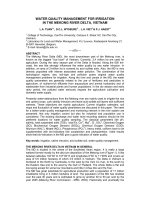
The 280,000 ha of forest in the MD can be split in two distinctive, typical eco-forest
wetlands using the Food and Agriculture Organization (FAO) guidelines: the inland
Melaleuca forest wetlands and the coastal mangrove forest wetlands [5] (Fig. 2, [6]).
Depending on their location in the MD the twenty two forest wetland sites are classified
as coastal (predominantly saltwater) and inland (predominantly freshwater) sites.
BirdLife International [1] identified on the basis of the habitat diversity of the site 10
priority wetlands for conservation. Table 1 lists the 11 most important and relevant
habitat types in each of those priority wetlands. The forest wetlands in the MD are
considered as the largest and richest ecosystems of Vietnam due to their development
in a very low topography, high humidity and temperature, interlacing rivers and canals
and abundant alluvium.
Mangrove forests is found along the country
’s 3,000-km coastline [7], and are the
harbour of at least 38 on a total of 46 plant species with economic value. Farmers use
mangrove trees mainly as a source of firewood and for construction. However,
mangrove forests are known for their high biodiversity to coastal fisheries and many
aquatic species. There are 77
Melaleuca plant species in which Melaleuca
leucodendron
plant is predominating throughout.
The exponential growth of the population in the MD, which expands annual with 2.3%, is
the primary cause of the increasing pressure on the natural resources and the tropical
eco-environmental system. Many mangrove forests are destroyed for aquaculture
farming (mainly shrimp, fishes and oysters), and
Melaleuca forests are cut for the
harvest of construction piles, rice cultivation and drainage works.
Melaleuca forests are
prune to fire every dry season. In general, the MD wetland area is being reduced by
unplanned forest exploitation and poor management. A recent study in the MD
discovered that every hectare of lost mangrove forest results in an annual loss of
roughly 0.7 tons of fish caught from the sea [8].
International Congress on Development, Environment and Natural Resources: Multi-level and Multi-scale
Sustainability
. Cochabamba, Bolivia, 11 – 13 July, 2007
------------------------------------------------------------------------------------------------------------------------------------------
Fig. 2: The forest wetland map of the MD [6]
Table 1: Areas of 11 broad habitat types at 10 priority wetland sites in the MD [1]
Area (ha)
Habitat type
Bai
Boi
Dat
Mui
Lung
Ngoc
Hoang
Vo Doi
U Minh
Thuong
Ha
Tien
Tra
Su
Tinh
Doi
Tram
Chim
Lang
Sen
Total
Mangrove
plantation
2,344 3,077
5,421
Regenerating
mangrove
748 1,134
1,882
Old growth
mangrove
771
711
Mudflat 1,504 1,050
2,554
Nypa fruiticans
swamp
646 720 519
1,366
Settlement and
agriculture
283 486 1,022 2,012 12,140 2,101 47 154 557 2,225
519
Open swamp 222 727 1,019 90 20 520 23
21,027
Grassland 1,721 8,509 85 379 3,609
2,621
Grassland with
Melaleuca
429 1,872 1,606 71 71 510 955
14,303
Melaleuca
plantation
1,040 5,500 2,309 3,188 568 581 2,099 970
5,514
Mature
Melaleuca forest
881 4,123 62 5,066
16,255
Total (ha)
5,525 7,238 2,713 10,992 22,918 14,388 861 1,644 7,740 3,280 77,299
International Congress on Development, Environment and Natural Resources: Multi-level and Multi-scale
Sustainability
. Cochabamba, Bolivia, 11 – 13 July, 2007
------------------------------------------------------------------------------------------------------------------------------------------
Under the population and economic pressure inhabitants of the MD are gradually
encroaching upon the forest areas for conversion to aquaculture and agriculture land,
timber exploitation and wildlife hunting. These human activities are threatening
dramatically the forests especially in wildlife reduction and forest fire. In an investigation
on forest fire in 2002 [7], about 8,212 ha of
Melaleuca forest in the Upper and the Lower
U Minh areas were burned, accounting for approximately 57% (17% in the Lower U
Minh and 40% in the Upper U Minh) of the total
Melaleuca forest area. In the U Minh
coastal forest areas, the existing peat layers in the soil, 150 cm thick, has been reduced
by 30 to 100 cm [9].
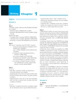
3.2. Action plan for the Mekong wetland forest
A four-level conservation action plan for wetland forests, meeting the objectives at
international, national, regional and site level was developed (Fig. 3). By 1993 more
than 75 countries, including Vietnam, became member of the Ramsar Convention. The
latter being an intergovernmental agreement offers a sound and stable framework for
international cooperation in the area of wetland conservation.
Fig. 3: Multi-level conservation scheme for forest wetlands in Vietnam