Hydrodynamics Natural Water Bodies Part 4 doc
Bạn đang xem bản rút gọn của tài liệu. Xem và tải ngay bản đầy đủ của tài liệu tại đây (6.25 MB, 25 trang )
Hydrodynamics – Natural Water Bodies
62
Fig. 11. Velocity contours of Coatzacoalcos River (rain and dry season) over time
4.4 Modeling of pollutant transport
This section presents some of the simulated parameters. Initially we describe the simulation
scenario solved to provide a better idea and understand clearly what the simulations are
representing.
4.4.1 Simulation scenario
To assess the water quality in Coatzacoalcos River, a representative discharge scenario was
initially defined, highlighting the main activities and characteristics over this area (Fig. 12).
The idea was study the river environmental behaviour, influenced by the oil activity
developed on this area, six discharges where located representing the industrial activity and
the influence of urban areas where such facilities industry are seated.
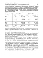
The discharge conditions for every simulated water quality parameter are presented in
Table 3.
Discharge Temp. (ºC) DO (mg/L) BOD (mg/L)
Faecal Col.
(NMP/100 ml)
Minatitlan
26.70 3.70 290.71 21,5000
Refinery
25.70 3.70 190.86 21,3000
Uxpanapa R.
24.70 3.70 190.70 21,7000
Nanchital
27.70 3.70 290.43 31,5000
Pajaritos P.C.
26.70 3.70 290.83 22,4100
Coatzacoalcos
25.70 3.70 110.60 21,4300
Table 3. Discharges conditions
A Study Case of Hydrodynamics and Water Quality Modelling: Coatzacoalcos River, Mexico
63
Fig. 12. Discharge scenario
The following figures show the model results for these water quality parameters.
Fig. 13. Temperature simulations over time
Hydrodynamics – Natural Water Bodies
64
Fig. 14. Biochemical Oxygen Demand simulations over time
Fig. 15. Dissolved Oxygen simulations over time
A Study Case of Hydrodynamics and Water Quality Modelling: Coatzacoalcos River, Mexico
65
Fig. 16. Faecal Coliforms simulations over time
5. Conclusions
The solution obtained for the two-dimensional Saint-Venant and A-D-R equations using an
Eulerian-Lagrangian method has great versatility, obtaining consistent and satisfactory
results for different types of flow and open channel conditions. The considered scheme
provides numerical stability that avoids numerical oscillations of the obtained solutions and
also allows significant larger time steps (Δt). The combination with the Eulerian solution for
diffusive terms is always guaranteed satisfying the C-F-L condition.
About the hydrodynamics study of Coatzacoalcos river, it was determined that the river
behaviour is influenced by several factors, being the most important the hydrological aspect,
which varies depending on the time of the year. Because of this, it was observed that dry
season presents an important tide penetration towards the mainland of the river, while for
rain season when the river flow increase, the penetration is less significant and the water
mainly flows downstream to the mouth in the Gulf of Mexico.
On the other hand, the pollutants transport is dominated strongly by the hydrodynamics,
and the difference for the two simulated seasons was observed. This simulation shows
higher concentrations and also a more significant dispersion in dry season, because the tide
penetration occurs intermittently upstream and downstream in the area near to the river
mouth. While for rain season there is no significant contaminant dispersion, with a local
effect of the simulated discharges.
Thus, a solution algorithm has been proposed to the study open channel hydrodynamics,
which together with the A-D-R equation solution allows the study of transport,
Hydrodynamics – Natural Water Bodies
66
transformation and reaction of pollutants, being the basis of the water quality model
proposed.
6. References
Bhallamudi, M.S. y Chaudhry, M. H. (1992). Two dimensional modelling of supercritical
and subcritical flow in channel transitions,
Journal Hydraulic Engineering, ASCE,
Vol.30, No.1, pp. 77-91.
Chaudhry, M. H. (1993). Open Channel Flow. Prentice Hall, New Jersey.
Gordon N., McMahon T., Finlayson B., Gippel C. & Nathan R. (2004).
Stream Hydrology: An
Introduction for Ecologists
. (2
nd
Ed.), John Wiley & Sons, ISBN: 0-470-84357-8. USA.
Mambretti S., Larcan E., Wrachien D. (2008). 1D modelling of dam-break surges with
floating debris.
Biosystem Engineering, vol. 100 (2008) 297 – 308. ISSN: 15375110.
Martin JL, McCutcheon STC. (1999).
Hydrodynamics and Transport for Water Quality Modeling.
Lewis, Boca Raton, FL.
Rodi, W. (1980). Turbulence models and their application in hydraulics: a state of the art
review,
Book publication of international association for hydraulic research, Delft,
Netherlands.
Rodriguez, C., Serre E., Rey, C. and Ramirez, H. (2005). A numerical model for shallow-
water flows: dynamics of the eddy shedding
. WSEAS Transactions on Environment
and Development
. Vol. 1, pp. 280-287, ISSN: 1790-5079
Salaheldin T., Imran J. & Chaudhry., M. (2000). Modeling of Open-Channel Flows with
Steep Gradients.
Ingeniería del Agua, vol. 7 ( 4), , pp. 391-408. ISSN: 1134-2196.
Seo II W. & Cheong TS. (1998). Predicting longitudinal dispersion coefficient in natural
streams.
Journal of Hydraulic Engineering. 124(1):25 – 32.
Torres-Bejarano F. & Ramirez H., (2007). The ANAITE model for studying the
hydrodynamics and water quality of natural rivers with soft slope.
International
Journal of Environmental Contamination
23 (3) (2007), 115-127. ISSN: 01884999.
Wang G., Chen S., Boll J., Stockle C., McCool D. (2002). Modelling overland flow based on
Saint-Venant equations for a discretized hillslope system.
Hydrological Processes, vol.
16 (12) (2002), pp. 2409 – 2421.
Ying X., Wang S. & Khan A. (2003). Numerical Simulation of Flood Inundation Due to Dam
and Levee Breach,
Proceedings of ASCE World Water and Environmental Resources
Congress 2003
, Philadelphia, USA, June 2003.
4
Challenges and Solutions for
Hydrodynamic and Water Quality
in Rivers in the Amazon Basin
Alan Cavalcanti da Cunha
1
, Daímio Chaves Brito
1
,
Antonio C. Brasil Junior
2
, Luis Aramis dos Reis Pinheiro
2
, Helenilza
Ferreira Albuquerque Cunha
1
, Eldo Santos
1
and Alex V. Krusche
3
1
Federal University of Amapá - Environmental Science Department and Graduated
Program in Ecological Sciences of Tropical Biodiversity
2
Universidade de Brasilia. Laboratory of Energy and Environment
3
Environmental Analysis and Geoprocessing Laboratory CENA
Brazil
1. Introduction
This research is part of a multidisciplinary research initiative in marine microbiology whose
goal is to investigate microbial ecology and marine biogeochemistry in the Amazon River
plume. Aspects related to Amazon River fluvial sources impacts on the global carbon cycle
of the tropical Atlantic Ocean are investigated within the ROCA project (River-Ocean
Continuum of the Amazon). This project is intended to provide an updated and integrated
overview of the physical, chemical and biological properties of the continuous Amazon
River system, starting at Óbidos, located 800 km from the mouth of the river, and interacting
to the discharge influence region at the Atlantic Ocean (Amazon River plume). This
geographic focal region includes the coast of the State of Amapá and the north of Marajó
archipelago in Northeast Brazilian Amazon.
The ROCA project is focused on the connection between the terrestrial Amazon River and
the ocean plume. This plume extends for hundreds of kilometres from the river delta
towards the open sea. This connection is vital for the understanding of the regional and
global impacts of natural and anthropogenic changes, as well as possible responses to
climate change (Richey et al. 1986; Richey et al. 1990; Brito, 2010). Different phenomena of
interest are typically linked to the quantity and quality of river water (flows of carbon and
nutrient dynamics) and the dynamics of sediments. All of them are strongly influenced by
substances transport characteristics and water bodies physical properties and physical
properties in the water bodies, constrained by spatial distribution of water flow (influenced
by bottom topography and coastline of river mouth archipelago) and the unsteady
interaction with tides and ocean currents. These very complex phenomena at the Amazon
mouth are still not fully understood.
Based on this framework, river and ocean plume hydrodinamics are fundamental
components in the complex interactions between physical and biotic aspects of river-ocean
Hydrodynamics – Natural Water Bodies
68
interaction. They drive biogeochemical processes (carbon and nutrient flows), variations in
water quality (physical-chemical and microbiological). They drive biogeochemical processes
(river bottom and suspended sediments) (Richey et al., 1990; Van Maren & Hoekstra, 2004,
Shen et al. 2010; Hu & Geng, 2011). The understanding of the Amazon River mouth flows is
an important and opened question to be investigated in the context of the river-ocean
integrated system.
In Brazil, the National Water Agency (ANA) monitors water flows at numerous locations
throughout the Amazon basin (Abdo et al. 1996; Guennec & Strasser, 2009). However, the
last monitoring station located on the Amazon River and nearest to the ocean is Obidos
(1°54'7.36"S, 55°31'10.43"W). There are no systematically recorded data available in
downriver locations towards the mouth. The Amapá State coast is, geographically, an ideal
site for such future systematic experimental flow measurements, since about 80% of the net
discharge of the Amazon River flows in the North Channel located in front of the city of
Macapá (0° 1'51.41"N, 51° 2'56.88"W) (ANA, 2008). The fact that this flow is not continuous
and varies with ocean tides, creating an area of inflow-outflow transition makes this region
a challenging subject for water research.
This research focus on two main issues: a) to establish an overview of physical aspects over
transect T
2
in the North Channel of the Amazon River, where measurements were
performed for quantification of liquid discharge and additional sampling procedures for
assessing water quality and quantify concentration of CO
2
in the air and water; b) to
evaluate typical local effects of river flow interacting with the shore and small rivers, based
on turbulent fluid flow modeling and simulation.
2. Main driving forces of the Amazon river mouth discharge
Tidal propagation in estuaries is mainly affected by friction and freshwater discharge,
together with changes in channel depth and morphology, which implies damping, tidal
wave asymmetry and variations in mean water level. Tidal asymmetry can be important as a
mechanism for sediment accumulation while mean water level changes can greatly affect
navigation depths. These tidal distortions are expressed by shallow water harmonics,
overtides and compound tides (Gallo, 2004). The Amazon estuary presents semidiurnal
overtides, where the most important astronomic components are the M2 (lunar component)
and S2 (solar component), consequently, the most common overtide is the M4 (M2 + M2)
and the main compound tide is the Msf (relative to fluvial flow). Amplitude characteristics
of the mouth of the Amazon River is represented by tidal components M2 and S2, of 1,5m
and 0,3m, respectively, corresponding to North Station Bar, Amapá State (Galo, 2004;
Rosman, 2007).
Form factor (F) expressing the importance of scale on components of the diurnal and semi-
diurnal tides, the Amazon estuary can be classified as a typical semi-diurnal tide (0 < F <
0.25). However, this classification does not considers the effects of river discharge. River
discharge certainly contribut to friction and to balance the effect of convergence in the lower
estuary and also to what happens between the platform edge of the ocean station and the
the mouth of the Amazon River.
There is evidence of nonlinearity in tidal propagation, which can be observed by the gradual
redistribution of power between M2 and its first harmonic M4. Considering tides as the sum
of discrete sinusoids, the asymmetry can be interpreted through the generation of harmonics
in the upper estuary (Galo, 2004; Rosman, 2007). In the case of a semi-diurnal tide, with its
Challenges and Solutions for Hydrodynamic and Water Quality in Rivers in the Amazon Basin
69
main components M2 and M4 first harmonic, the phase of high frequency harmonic wave
on the original controls the shape of the curve and therefore the asymmetry.
Three major effects characterize the amount and behaviour of flow it the mouth of the
Amazon River: (a) relative discharge contributions from sub-basins of the main channel; b)
tidal cycles and; (c) regional climate dynamics.
According to Gallo (2004) the Amazon River brings to the Atlantic Ocean the largest flow of
freshwater in the world. Based on Óbidos records, there is an average flow of approximately
1.7x10
5
m
3
/s, with a maximum of approximately 2.7x10
5
m
3
/s and a minimum of 0.6x10
5
m
3
/s. According to ANA (2008), the flow reaches a net value of approximately 249,000 m
3
/s,
with a maximum daily difference of 629,880 m
3
/s (ebb) and a minimum of -307,693 m
3
/s
(flood). The most important contributions come from the Tapajós River with an average flow
of approximately 1.1x10
4
m
3
/s, the Xingu River with an average of approximately 0.9x10
4
m
3
/s and Tocantins River, at the southern end of the platform, with an approximate average
flow of 1.1x10
4
m
3
/s.
Penetration of a tidal estuary is result of interaction between river flow and oscillating
motion generated by the tide at the mouth river, where long tidal waves are damped and
progressively distorted by the forces generated by friction on river bed, turbulent flow
characteristics of river and channel geometry. Gallo (2004) describes that propagation of the
tide in estuaries is affected mainly by friction with river bed and river flow, as well as
changes in channel geometry, generating damping asymmetry in the wave and modulation
of mean levels. Such distortions can be represented as components of shallow water, over-
tides and harmonic components. The Amazon River estuary can be classified as macrotidal,
typically semi-diurnal, whose most important astronomical components are M
2
(principal
lunar semidiurnal) and S
2
(Principal solar semidiurnal) and therefore the main harmonics
generated are high frequency, M
4
(lunar month) and the harmonic compound, Msf
(interaction between lunar and solar waves) (Bastos, 2010; Rosman, 2007).
In the Amazon the most important climatic variables are convective activity (formation of
clouds) and precipitation. The precipitation regime of the Amazon displays pronounced
annual peaks during the austral summer (December, January and February - DJF) and
autumn (March, April and May - MAM), with annual minima occurring during the austral
winter months (June, July and August - JJA) and spring (September, October and November
- SON). The rainy season in Amapá occurs during the periods of DJF and MAM (Souza,
2009; Souza & Cunha, 2010).
The variability of rainfall during the rainy season is directly dependent on the large-scale
climatic mechanisms that take place both in the Pacific and the Atlantic Oceans (Souza,
2009). In the Pacific Ocean, the dominant mechanism is the well-known climatic
phenomenon El Niño / Southern Oscillation (ENSO), which has two extreme phases: El
Niño and La Niña. The conditions of El Niño (La Niña) are associated with warming
(cooling) anomalies in ocean waters of the tropical Pacific, lasting for at least five months
between the summer and autumn. In the Atlantic Ocean, the main climatic mechanism is
called the Standard Dipole or gradient anomalies of Sea Surface Temperature (SST) in the
intertropical Atlantic (Souza & Cunha, 2010).
This climate is characterized by a simultaneous expression of SST anomalies spatially
configured with opposite signs on the North and South Basins of the tropical Atlantic. This
inverse thermal pattern generates a thermal gradient (inter-hemispheric and meridian) in
the tropics, with two opposite phases: the positive and negative dipole. The positive phase
of the dipole is characterized by the simultaneous presence of positive / negative SST
Hydrodynamics – Natural Water Bodies
70
anomalies, setting the north / south basins of the tropical Atlantic Ocean. The dipole
negative phase of the configuration is essentially opposed. Several observational studies
showed that the phase of the dipole directly interferes with north-south migration of the
Intertropical Convergence Zone (ITCZ). The ITCZ is the main inducer of the rain weather
system in the eastern Amazon, especially in the states of Amapá and Pará, at its
southernmost position defines climatologically the quality of the rainy season in these states
(Souza & Cunha, 2010). The behavior of the climate is important because it significantly
influences the hydrological cycle and, therefore, the hydrodynamic and mixing processes in
the water.
According to Van Maren & Hoesktra (2004) the mechanisms of intra-tidal mixing depend
strongly on seasonally varying discharge (climate) and therefore hydrodynamics. In this
case, during the dry season, there is a breakdown of stratification during the tidal flood that
occurs in combination with the movements of tides and advective processes. Intra-tidal
mixing is probably greater in semi-diurnal than in diurnal tides, because the semi-diurnal
flow velocity presents a non-linear relationship with the mixture generated in the river bed
and the mean velocity.
A second, Hu & Geng (2011), studying water quality in the Pearl River Delta (PRD) in
China, found that coupling models of physical transport and sediments could be used to
study the mass balance of water bodies. Thus, most of the flows of water and sediment
occur in wet season, with approximately 74% of rainfall, 94% water flow and 87% of
suspended sediment flow. Moreover, although water flow and sediment transport are
governed primarily by river flow, tidal cycle is also an important factor, especially in the
regulation of seasonal structures of deposits in river networks (deposition during the wet
season and erosion in the dry season). As well as net discharge there are several types of
physical forces involved in these processes, including: monsoon winds, tides, coastal
currents and movements associated with gravitational density gradients. Together these
forces seem to jointly influence the control of water flow and sediment transport of that
estuary.
A third example, according to Guennec & Strasser (2009), hydrodynamic modeling along a
stretch of the Manacapuru-Óbidos river in the upper Amazon a stretch of the Manacapuru-
Óbidos river in the upper Amazon revealed that the ratio of liquid flow that passes through
the floodway changes from 100% during the low water period to 76% (on average) during
the high water period. Expressed in volume, this means that about 88% of the total volume
available during a hydrological cycle moves through the floodway of the river, and only
12% moves through the mid portion. The volume that reaches the fringe of the flood plain is
approximately 4% and appears to be temporarily stored.
Based on the climatic characteristics of the State of Amapá, one of the main challenges for
both hydrological and hydrodynamic studies is to integrate meteorological information
from the Amazon Basin and include these forces when evaluating the responses of aquatic
ecosystems in the Lower Amazon River estuary (Brito, 2010; Bastos, 2010; Cunha et al., 2006;
Rickey et al., (1986), Rosman (2007), Gallo (2004), ANA (2008) and Nickiema et al., (2007).
3. River flow measurements in Amazon North Channel
In the Amazon River (North Channel) two up to date measurements of net discharges were
made. The measuring process, consists of: 1) performing a series of flow measures over a
minimum period of 12.30 h, using ADCP with an average of 12 experimental measurements;
Challenges and Solutions for Hydrodynamic and Water Quality in Rivers in the Amazon Basin
71
2) interpolate the temporal evolution of flow and velocity from these measurements; 3)
integrate the values with the tidal cycle to obtain the average flow rate (or velocity); 4)
analyze the maximum and minimum flow, and the relationship between flow/velocity and
level, as described by ANA (2008), Cunha et al. (2006) and Silva & Kosuth (2001).
Fig. 1 shows the location of Transect T2 (blue line) of the North Channel and Matapi River,
both studied by Brito (2010) and Cunha (2008) nearly to city of Macapá, respectively .The
requirement for local knowledge of the river bathymetry is demonstrated by the geometric
complexity of the channels and variations in the average depths of the channel. Cunha
(2008) observed depths ranging from 3 m (minimum) to approximately 77 m (maximum) in
the section indicated.
Brito (2010) has studied the water quality sampled water quality and participated in the
quantification of the measurements of liquid discharge in the North Channel. The width of
the North Channel is approximately 12.0 kilometres (30/11/2010). The width of the South
Channel was approximately 13.0 kilometres (12/02/2010).
Fig. 1. Features in river sections close to Transect T2 located in the North Channel of the
Amazon River – Amapá State (S0 03 32.2 W51 03 47.7)
3.1 Methodological approach for discharge measurement in large rivers
Muste & Merwade (2010) describe recent advances in the instrumentation used for
investigations of river hydrodynamics and morphology including acoustic methods and
remote sensing. These methods are revolutionizing the understanding, description and
modelling of flows in natural rivers.
Hydrodynamics – Natural Water Bodies
72
Stone & Hotchkiss (2007) report that accurate field measurements of shallow river flows are
needed for many applications including biological research and the development of
numerical models. Unfortunately, data quantifying the velocity of river current are difficult
to obtain due to the limitations of traditional measurement techniques. These authors
comment that the mixing processes and transport of sediment are among the most
important impacts on aquatic habitat. The velocity of large rivers is typically measured in
either stationary or moving boats with reels or ADCP (Acoustic Doppler Current Profiler).
ADCPs are designed to measure the velocity of the current in a section of a watercourse,
producing a velocity profile of the section based on the principle of sound waves from the
Doppler effect. This effect is a result of the change in the frequency of the echo (wave) which
varies with the motion of the emitting source or reflector. Using this technique, it is possible
to measure more accurately net discharge i) in sites and ii) on occasions where the task of
measuring flow is more difficult with traditional techniques. At the same time results from
ADCP are comparable with results from techniques using traditional methods and can be
used to evaluate the qualitative discharge of suspended sediments. In both cases, the
technique can be applied in specific monitoring programs (Abdo et al., 1996).
The ADCP has some technical advantages over more traditional techniques (e.g.
quantitative net discharge) in places where there are difficulties in applying traditional
methods, such as large rivers, during the wet season, discontinuous river sections, and some
authors recommend that its use should become more common in estuaries (Guennec &
Strasser, 2009). The main advantages of using ADCP are: a greater quantity and quality of
data, improved accuracy (5%); measurements are obtained in real time, with a high rate of
reproductibility. The technique for measuring liquid discharge using ADCP technique is
also faster is also faster than conventional methods and can be used in large and small water
bodies. Furthermore, it requires less effort, does not need alignment, allows for the
correction of detours in discrete river sections, and estimating the motion of sediment on the
river bed. It also demonstrates a good correlation with the more conventional methods,
permitting to obtain of section profiles, river width, flow velocity, the qualitative
distribution of suspended sediments, measurement time, boat speed, water temperature and
salinity (Guennec & Strasser, 2009).
According to Muste & Merwade (2010) recent advances in instrumentation for the analysis
of river flows include the combination of acoustic methods with remote sensing to quantify
variables and hydrodynamic and morphological parameters in natural bodies of water, and
notably the degree of importance of these new technologies is more evident when applied to
large rivers under tidal influence (Abdo et al. 1996; Martoni & Lessa, 1999).
These instruments can be quick and efficient in providing detailed multidimensional
measures that contribute to the investigation of complex processes in rivers, especially
hydrodynamics, sediment transport, availability of habitats and ecology of aquatic
ecosystems.
Muste & Merwade (2010) describe how to quantify the hydrodynamic characteristics and
morphology of complex channels. In addition to the ability to extract information that is
available through conventional methods in the laboratory, the ADCP and MBES (Multibeam
Echosounder) can provide additional information that is critical to the understanding and
development of modelling processes in rivers, for example providing a 3D view of river
hydrodynamics that was previously unavailable to hydrological studies of large rivers.
A major challenge for studies involving large rivers in the Amazon is the operation of flow
meters. For example, the United States Geological Survey (USGS) operates more than 7,000
Challenges and Solutions for Hydrodynamic and Water Quality in Rivers in the Amazon Basin
73
net discharge monitoring stations in the U.S. These stations provide a near real-time data
flow from all stations on the Internet, generating data of water column depth, or the flow
stage discharge-curves at each location.
However, a significant challenge for large rivers is the fact that the channel bed, sediment
and/or sand banks move location over time. Thus, the discharge-curves need to be updated
through regular measurements of the depth, breadth and speed of the river at the
monitoring stations. Such difficulties have led to the replacement of conventional techniques
with measurements of velocity and net discharge. But at the same time, a vast storage
capacity for the data obtained is required, especially when the ADCP data are combined
with topography. For example, the data storage requirements have increased from the order
of hundreds of thousands to the order of millions of bathymetric and hydrodynamic
information points (Muste & Merwade, 2010).
This obstacle requires massive investments in instruments with extraordinary data
processing abilities in order to store, group, process and quickly distribute data in a myriad
of different formats to fulfil information needs of users. On the other hand, the numerical
models developed to accommodate the 3D information of hydrodynamics and bathymetry
is only available with the use of intensive techniques like ADCP or MBEs.
Dinerhart & Burau (2005) used the ADCP in the Sacramento River (CA/USA) in diurnal
tidal rivers for mapping velocity vectors and indicators of suspended sediment. They
observed that in surface waters, the ADCP is particularly useful for quickly measuring the
current discharge of large rivers with non-permanent flows, presenting several advantages
such as visualisations of time based flows and sediment dynamics in tidal rivers.
Another important parameter in the biogeochemical cycle of aquatic ecosystem is the
longitudinal dispersion. The longitudinal dispersion coefficient (D) is an important
parameter needed to describe solute transport along river currents (Shen et al., 2010). This
parameter is usually estimated with tracers. For economic and logistical reasons, the use of the
latter is prohibitive in large rivers.
The same authors argue that these shortcomings can be overcome with the use of ADCP
simultaneously with tracers in the stretch of river, by examining the conditions under which
both methods produce similar results. Thus, ADCP appears to be an excellent alternative /
addition to the traditional tracer based method, provided that care is taken to avoid
spurious data in the computation of weighted average distances used in the representation
of the average conditions of the river stretch in question.
Stevaux et al. (2009) studied the structure and dynamic of the flow in two large Brazilian
rivers (the Ivaí and the Paraná) using eco-bathymetry and ADCP together with samples of
suspended sediments. This occurred in two phases of the hydrological cycle (winter and
summer). The methodology proved to be valid and easily transferable to other river systems
of similar dimensions. For example, at the confluences of river estuaries with complex
hydraulic interactions resulting from the integration of two or more different flows,
constituting a “competition and interaction" environment. This is because continuous
changes occur in flow velocity, discharge and structure, in addition to the changes in the
physical and chemical properties of water quality and channel morphology. These dynamic
systems are very important in river ecology, reflecting many features and limiting
conditions of the environment.
According to Stevaux et al. (2009), from a hydrological perspective, the confluences can be
considered as likely sites of turbulence and convergent or divergent movements, forming
upward, downward or lateral vortices. These effects generate chaotic motion, generating
Hydrodynamics – Natural Water Bodies
74
secondary currents of differing velocities and directions, including some that feedback to the
flow main current.
For these authors these dynamics induce the main movement of the sediment formed in the
river bed and consequently the main source of variation and alteration in the shape of the
channel bed. In this case, highlights the main factors controlling mixing in channel
confluences: morphological, such as the confluence angle and asymmetry of the channel
bed; and hydraulics, such as momentum and contrast in the flow density. These results also
confirmed that the identification and understanding of flow mixing at river confluences is
very important in studies of pollution, nutrients, dispersal of dissolved oxygen, and other
ecological variables (Rosman, 2007; Bastos, 2010; Cunha, 2008; Pinheiro, 2008). The rate of
movement of the flow can be used to determine flow predominance in the confluence.
3.2 ADCP Measurements in North Channel
According to ANA (2008) measurements occurred in the section of the channel, located
between Amapá Coast and island of Marajó, North Channel of the Amazon River, with the
total time to perform the measurement of the 12 hours and 40 minutes.
Due to the effect of tidal flow and the flow directions of the channel of the Amazon River at
its mouth, to determine the actual flow of the river the flow is continuously measurement
during a tidal cycle. Or more precisely, it is necessary to perform measurement during a
wave variation of flow generated due to influence of the tide.
Considering the peculiarities of the flow measurement under the influence of the tide and
large transect of the North Channel of the Amazon River at its mouth (about 11.9 km), the
traditional methods of measuring flow in large rivers do not apply to flow measurement in
this situation.
The measurements of flow at the mouth or the Amazon were only possible through the
development of equipment for flow measurement by Doppler effect (ADCP) due to the
drastic reduction of time required for measurement and reduction of risk associated.
Calculation of the total duration of measurement: the total length is determinate by
measurement the time difference between initial and final wave flow due to the tidal cycle,
expressed in seconds.
Since the wave due to the tidal cycle can be represented by a periodic wave, the start and
end times are obtained by the abscissas corresponding to the intersection points of the flow
versus time curve with a straight parallel to the axis “x” vs Q (discharge), whose first
derivative has the same sign, i.e. at points where the curve is increasing (positive derivative)
or descending (negative derivative). The calculation of the actual flow in the section is done
by determining the area under curve Q x t, which corresponds to the total volume of water
that passed through the measurement section during the period of the wave flow, divided
by the total time duration. Determination of the flow of the North Channel were performed
on different days, the first is the simple sum of three part of effective flow rates measured.
The second involves the propagation of waves flow measurements performed by the same
reference time, the sum of curves “overlapping” and integrating.
The expected outcome of this type of information is the realisation of regular "in situ"
hydrodynamic measurements, to understand the relationship between river hydrodynamics
and biogeochemical factors along this key stretch of the Amazon River (Transect T2) near
Macapá-AP. The idea is to integrate them to control upstream hydrodynamics and
biogeochemistry, as well as to understand how the ecosystem may responds to
anthropogenic climate change (Fig. 2).
Challenges and Solutions for Hydrodynamic and Water Quality in Rivers in the Amazon Basin
75
Fig. 2. Net discharge measured with ADCP (600Hz). a) North Channel profile, with
Q = 1.3x10
5
m
3
/s (12/05/2010), b) South Channel, with Q = 1.2x10
5
m
3
/s (12/07/2010).
4. Carbon and nutrient biogeochemistry at the Mouth of the Amazon River
Brito (2010) prepared a review based on some of the main studies from the ROCA project
that indicated that the tropical North Atlantic Ocean can be considered a source of
approximately 30 Tg C yr-1 into the atmosphere.
But Subramaniam et al (2008) found a carbon sink of similar magnitude with biologically
measures of approximately 28 Tg C yr-1 from the atmosphere to the ocean, resulting from
nitrogen and phosphorus in the river, in addition to the fixation of N
2
in the plume of the
Amazon River. Thus, the Amazon plume reverses the normal oceanic conditions, causing
carbon capture and sequestration of CO
2,
defined as the net remover of carbon from the
Hydrodynamics – Natural Water Bodies
76
atmosphere to the ocean (Dilling, 2003; Battin et al, 2008; Ducklow et al., 2008; Legendre and
Le Freve, 1995).
Subramaniam et al (2008) revealed the importance of symbiotic associations of diazotrophic
diatoms (DDAs) in nitrogen fixation in the Amazon plume and showed that the chemical
outputs associated with these organisms represent a regionally significant carbon sink.
DDAs or other agents of N
2
fixation have also been found in other tropical river systems,
such as the Nile (Kemp et al., 1999), Congo (AN, 1971), the South of China Sea (Voss et al.,
2006) and the Bay of Bengal (Unger et al., 2005), and it is speculated that these have global
significance, as a previously neglected biological carbon pump.
These results suggest that techniques used to study inland waterways of the Amazon may
be applied to other systems e.g. the Amazon plume. However, knowledge about the
magnitude, spatial extent and final destination of this plume is limited. The importance of
connections with the processes that occur upstream are also very poorly known.
Independent measurements of net community production, diazotrophic production and
flow of particles near the surface of the plume agree with the export of carbon
(Subramaniam et al., 2008), but the ultimate fate of carbon and nitrogen and the sensibility
of the plume front to global climate change are currently unknown.
The microbial community is a driving force behind the processing of material along the
Amazon continuum, from land to sea. Cole (2007) suggested that the biosphere should be
considered as a metabolically active network of sites that are interconnected by a fluvial
network.
Despite indications that the organic carbon derived from soil is resistant to degradation on
land, remaining stored for decades or centuries (Battin et al., 2008), once released into
aquatic ecosystems, there is evidence that this carbon is dissolved rapidly in the rivers in a
matter of days or weeks (Cole & Caraco, 2001).
High levels of CO
2
and low O
2
concentrations are often found in muddy rivers (Brito, 2010)
which suggests that organic carbon derived from the soil represents a substantial carbon
source for the heterotrophic network of the river ecosystem (Richey, 1990).
Current knowledge about the diversity and dynamics of bacterioplankton comes almost
exclusively from studies of lakes (Crump et al., 1999). Various small rivers have also been
sampled (Cottell et al., 2005; Crump & Hobbie, 2005), but from 25 of the world's major
rivers, only four had their genetic sequences recorded in the bacterioplankton "Genbank"
(National Center for Biotechnology and Information, U.S. National Library of Medicine): the
Columbia River, USA (Crump et al., 1999), the Changjiang River, China (Sekigushi et al,
2002), the Mackenzie River, Canada (Galand et al., 2008) and the Paraná river, Brazil
(Lemke, 2009).
The lack of information regarding bacterioplankton in large rivers limits understanding of
global biogeochemical cycles and the ability to detect community responses to biotic and
anthropogenic climate impacts in these critical ecosystems (Crump et al., 1999).
In less turbid areas of the continuum, the process of photosynthesis can reduce or even
reverse the CO
2
emission rate (Dilling, 2003). Likewise, when the river meets the sea, the
loss of suspended sediment increases the penetration of light sufficiently to stimulate
marine primary production (Smith & Demaster, 1995). Once light has been removed as a
limiting factor nutrients released by river “metabolism” allow phytoplankton blooms,
whose community structure is probably dependent on concentrations and ratios of
(limiting) nutrients such as nitrogen, phosphorus and iron (Dilling, 2003; Subramaniam et
al., 2008).
Challenges and Solutions for Hydrodynamic and Water Quality in Rivers in the Amazon Basin
77
One of the main unifying conceptual frameworks in biological oceanography is the idea that
the structure of the phytoplankton community profoundly affects the export and
sequestration of organic material. That is, the biological carbon pump and chemical nutrient
cycles (Michaels & Silver, 1988; Wassman, 1988; Peinert et al., 1989; Legendre & Le Fevre,
1995, Ducklow et al., 2001).
Cyanobacteria are recognised as a particularly important group of organisms in the carbon
cycle, occurring in a wide variety of ecosystems, especially in aquatic environments.
Cyanobacteria can survive in extreme conditions and are found in habitats with wide ranges
of temperature, salinity and nitrogen availability (Falconer, 2005). The abundance of
cyanobacteria varies seasonally, as a consequence of changes in water temperature and solar
radiation as well as weather conditions and nutrient supply (Falconer, 2005). It is known
that their distribution it is not homogeneous on the surface or in water column. The
distribution of cyanobacteria assemblages may vary depending on gradients such as depth,
salinity, temperature, space and seasonality. However, as well as a lack of studies in this
area, it is difficult to analyze the dynamics and diversity of planktonic groups such as
cyanobacteria, especially when the analytic scale is at the species level, where diversity is
high and the river area to be sampled is enormous.
4.1 Methods and preliminary biogeochemistry results of transect T2
In the North and the South Channel in Amapá, sampling of water quality was conducted
with i) quarterly and ii) in the Channel North monthly frequency (Brito, 2010). Quarterly
collections are used to obtain vertically and horizontally integrated samples for the
calculation of dissolved and particulate loads in the water column with the use of 15 to 20
metre boats. The monthly samples are used for seasonal interpolation and are obtained from
the surface and 60% of water depth. The measures routine collected are used to derive
parameters relating to the ion and nutrient system, carbonates, organic material, water
discharge and suspended sediment.
The depth and surface samples are obtained by immersion pumps, where water is then
pumped into a graduated cylinder of 2 litters, which is flooded for at least three times prior
to sampling and the overflow is maintained during the procedures sampling.
Transect T2 (Table 1) defines the main flow of the river to the north of the island of Marajo. As
sea water never passes the dividing line at the mouth of the river in front of the city of Macapá
(Nikieme et al., 2007), this is considered a final a purely fluvial compounent of the river.
Point Local Coordinates
Left Bank - North Channel Amazon S0 03 32.2 W51 03 47.7
Middle River - North Channel Amazon S0 04 35.9 W51 01 46.7
Right Bank - North Channel Amazon S0 05 01.9 W51 00 21.9
Left Bank - South Channel Amazon S0 09 51.8 W50 37 48.9
Middle River - South Channel Amazon S0 10 43.0 W50 36 59.4
Right Bank - South Channel Amazon S0 11 59.8 W50 35 59.7
Table 1. Geographical coordinates of sampling sites
Hydrodynamics – Natural Water Bodies
78
The graduated cylinder 2 liters are removed aliquots with syringes of 60 mL for routine
analysis of chemical parameters Na
+
, K
+
, Ca
2+
, Mg
2 +
, Al, Si, Cl
-
, SO
4
2-
, NO
2
-
, NO
3
-
, NH
4
+
,
PO
4
3-
, total nitrogen and dissolved organic carbon (DOC). Chemical parameters for the
samples are filtered using cellulose acetate filters with pore size 0.45 micrometres in bottles
of high density polyethylene capacity of 60 mL containing 6 mg of thymol as a preservative.
For DOC, samples are filtered in triplicate using glass fiber filters preheated (500 °C for 5
hours) GFF type with pore size 0.7 mm, in glass vials of 25 mL, also preheated. Samples are
preserved with 25 mL of HCl 50%.
In situ measurements (meter used) are: electrical conductivity (Amber Science 2052);
pH and temperature (Orion 290A plus), and dissolved oxygen (DO) with the YSI 55
meter.
To fill the collection tube, using the same technique of overflow, ten bottles of glass BOD
(Biochemical Oxygen Demand) of 60 mL for measurements of respiration rates are used. Of
these, five bottles are preserved with 0.5 mL of manganous sulfate and 0.5 mL of sodium
azide and five bottles are incubated in coolers containing water from the river, staying in the
dark for 24 hours.
To measure the concentration of suspended sediment in the water, are filled with twenty
gallons of polyethylene-liter and transported to the laboratory for further processing to
separate the coarse particles (up to 63 µm) of fine particles (between 0 and 63 µm, 45 µm)
samples.
The sampling parameters of fecal coliform and Escherichia coli, coliform, sterile bags are
made directly from the collector tube connected to the pump.
During the sampling process, a phytoplankton net (63μm mesh) is submerged in the side of
the boat to collect coarse sediments. At the end of sampling, the content network is rinsed
polycarbonate flask of 250 ml wide mouth and preserved with 250 mL of HCl 50%. To
measure the isotopic composition of carbon and nitrogen.
To measure the concentration of dissolved CO
2
, water is pumped through a closed
plexiglass tube in which a small part is filled with air, this air is pumped out of the pipe to a
device called a CO
2
analyzer IRGA (InfraRed Gas Analyzer ) Licor LI820 model, after
passing through the analyzer back to the air pipe to reach the equilibrium (Cole et al, 1994.
With modifications). Expected to balance the flow of air, so it made measurements of CO
2
dissolved in water for 5 minutes.
The flux measurements of CO
2
in surface water are made by the same method, but instead
of the plexiglass tube to balance the flow of CO
2
it uses a static camera that is floating on the
surface of the river connected to tubes to circulate air to the IRGA for 5 minutes.
In addition, samples are collected to characterization of phytoplankton for identification and
determination of density.
Table 2 shows the preliminary results of some parameters obtained in the first gathering
held in the channel north, following Brito (2010):
With preliminary data observed, we cannot make qualitative and quantitative analysis
representative. But we can highlight some features of the river, such as the harmony of
the data of surface and depth, the good condition of dissolved oxygen in water, acid
pH which is a characteristic of the Amazonian rivers, the presence of considerable
amounts of iron in water, low water hardness, the presence of nutrients in the water and
the high level of carbon dioxide dissolved in water (mass transfer through air-water
interface).
Challenges and Solutions for Hydrodynamic and Water Quality in Rivers in the Amazon Basin
79
Table 2. Preliminary results and physical-chemical in Transect T2, in the North Channel
(two water sampling).
Hydrodynamics – Natural Water Bodies
80
5. Numerical modeling
The propagation of the tidal flow in estuaries is a complex free surface problem. It is unsteady
oscillatory and therefore may have reversal flow that is not uniform. The equations governing
the flow (conservation of mass and movement) are not linear due to friction, the spatial
variations velocity and changes in the dimension of the estuary (Gallo, 2004, Cunha, 2008).
Thus, to resolve the hydrodynamic in general and the propagation of the tidal estuary, taking
into account this complexity, it is necessary to use numerical models to represents the average
flow.
According to Versteeg & Malalasekera (1995) a turbulence model can be considered a
computational procedure applied to close the system of equations used to represent the
average flow, and calculations applicable to a variety of generic problems regarding flow
dynamics. The authors state that one of the models most useful in solving the set of
equations to be solved for the transport of Reynolds stresses is the k-
model. The standard
k-ε
model presents two equations, one for k and one for
based on our understanding of the
processes that cause relevant changes in these variables. The turbulent kinetic energy k is
defined as the variance of velocity fluctuations and
is the dissipation of turbulent kinetic
energy (the rate at which turbulent kinetic energy is dissipated in the flow). k-
turbulence
model and the SST (Shear Stress Tensor - a more complex variant of the k-
model) were
used respectively for closing the Reynolds equations (Cunha, 2008; Pinheiro & Cunha, 2008).
Cunha (2008) and Pinheiro & Cunha (2008) conducted two case studies with numerical
models using the software CFX/ANSYS 1) coastal area on the coast of the city of Macapá,
and 2) the Matapi River, near the Industrial District of the city of Santana (0° 0'32.53"S,
51°12'7.43"W) (Fig. 3a and 3b). In both cases, the objective was to study the dispersion
behaviour of pollutant plumes into surface waters in the estuary of the Lower Amazon and
their behaviour during a semi-diurnal tidal cycle.
Fig. 3. Pre-processing within a CFX (Computational Fluid Dynamics) study of the dispersion
of pollutants in the estuarine zone next to Macapá: a) Macapá and Santana Coast; b) Matapi
River (point 8 in Fig. 3a), near the Island and Industrial District of Santana-AP.
Challenges and Solutions for Hydrodynamic and Water Quality in Rivers in the Amazon Basin
81
Fig. 4. Velocity and dispersion of pollutants in natural runoff - in the coast of the cities of
Macapá and Santana. Representation of a semi-diurnal tidal cycle.
Hydrodynamics – Natural Water Bodies
82
Fig. 3a illustrates the pre-processing step for simulation of pollutant dispersion and
demonstrates the complex geometrical configuration required to represent the turbulent
flow. There are six continuous pollution sources in the cities of Macapá and Santana, from
the mouth of the Matapi River (southern area) to the north of the city, the upper area of the
figure. The natural flux of flows passes from the bottom (left) to top (far right, in the north
and northeast). The continuous point sources of pollutants are represented by red circles
along the coast, which represent the main release points of untreated pollutants into the
waters in Macapá and Santana cities (Pinheiro & Cunha, 2008). The same representation
occur in Rio Matapi indicated by Fig 3b (Cunha, 2008).
Fig. 4 shows the results of the simulations of pollutant dispersal plumes (light blue and
reddish margins) during a tidal cycle. These maps show that the plumes tend to stay close to
the shore. From left to right (top row) is the initial phase of a simulated low tide
(approximately 7 hours). Again, from left to right (bottom row) begins the high tide phase
(approximately 5.5 hours). During the tidal cycle it was possible to simulate the complex
interactions between hydrodynamics and a coupled scalar (hypothetical pollutant), with an
emphasis on the dynamic plumes between mainland Santana and the island of Santana.
Case study 2 (Fig. 5), shows the phases of the dispersion of pollutant plumes (hypothetical
tracer) in the Matapi River during a tidal cycle. The flow pattern (streamlines) changes
significantly over a period of the semi-diurnal tide. Simulating the dispersal of pollutants
indicates a remarkable complexity in the flow, depending on the geometry of the river
channel and the timing of the reversal of the tidal cycle.
In Fig. 5, from left to right depicts changes in pollutant plumes during low tide
(approximately 7 hours), during a complete semi-diurnal tidal cycle, where the natural flux
of the tide flows from top to bottom. The reverse shows the rising tide.
In Fig. 6, from left to right, there are three different flow fields indicated: a) velocity vectors,
b) streamlines (paths of constant speeds), c) dispersion pattern of the scalar from two
(hypothetical) continuous point sources of pollutants.
Fig. 5. Lines of transient currents in the Rio Matapi: a) low tide at t = 1h, b) end of the ebb at
t = 5.5 h, c) reversal of the tide at t = 6h.
Challenges and Solutions for Hydrodynamic and Water Quality in Rivers in the Amazon Basin
83
In both case studies, despite the sophistication of the numerical analysis, technical advances
such as calibration and validation of models are still necessary. The complexity of the
process involving modelling steps, proceedings to investigate the aquatic biogeochemistry
and hydrometry of large rivers have yet to beovercome in the estuarine region of Amapá.
Fig. 6. Low and rising tides. t = 360 min (6.0 h). a) Velocity; b) Stream line; b) Plume
Concentration.
6. Conclusions
The main conclusions of this research are:
In the estuarine region of the Lower Amazon River, in the state of Amapá, the measurement
of net discharges of large tidal rivers is only feasible with the use of devices such as ADCP
to integrate hydrodynamic processes and water quality variables (biogeochemical cycle and
interaction between the plume of the Amazon River and Atlantic Ocean).
Relevant hydrodynamic parameters such as velocity profiles, stress and identification of
background turbulent flow velocity components need to be determined with the aid of
modern equipment whose operation must be efficient and economic for hydrometric
quantification in complex estuarine environments.
Bathymetric analyses, at the scales of interest, have been a difficult hurdle to overcome
because of the intricate system of channels in the Amazon River.
The logistics required for experimental studies in large rivers is a major obstacle that has
inhibited research interest in this poorly studied area.
A major challenge to be overcome in systematic studies of water quality parameters is the
generation of local physical parameters, such as rating curves, rates of sedimentation and
resuspension of sediments, etc, which are a fundamental input for complex numerical
models of water quality.
Hydrodynamics – Natural Water Bodies
84
The modelling of water quality in the Amazon estuary is complex due to the absence and /
or inadequacy of data describing different physical characteristics. The drainage system
imposes enormous difficulties in this area. An example is the absence of long-term time
series to obtain necessary parameters and coefficients to build numerical models.
Hydrodynamic simulations of flow and dispersion of pollutant plumes released into the
environment are difficult to implement, and require calibration and verification with local
data that are not always available.
Existing techniques in numerical modelling can become strong allies in informing public
policy and the management of regional water resources.
Among the parameters of interest from numerical models, the generation of 3D
computational meshes is potentially the most important source of novel information.
The development of local expertise constitutes one of the biggest challenges in the area,
since the best and most efficient option for development of experimental studies
in hydrodynamics and computer simulation, is the formation of local human resources.
The main advantages are lower operating costs for complex experimental campaigns.
The implementation of a database accessible to the interested user would also be an
important technological challenge for the systematic studies of the hydrodynamics and
water quality at this region. Thus, would be possible to improve our understanding about
the ecosystem functioning and to evaluate the complexity of the Amazon estuary and the
role of carbon cycle in these environments.
7. Acknowledgements
This research is part of the ROCA project (River-Ocean Continuum of the Amazon), funded
by the Gordon and Betty Moore Foundation. The main collaborating institutions are the
Center for Nuclear Energy in Agriculture - CENA / USP, the National Institute of
Amazonian Research - INPA, the Museu Paraense Emilío Goeldi - MPEG, Federal
University of Pará - UFPA and the Federal University of Amapá - UNIFAP (Postgraduate
Program in Tropical Biodiversity / PPGBIO and the Laboratories of Simulation and
Modeling, Chemistry and Environmental Sanitation / Undergraduate Program in
Environmental Sciences). This study was supported by the National Research Council
(CNPq/MCT – Productivity Fellowship (Process N. 305657/2009-7), and by the Institute of
Scientific and Technologic Research of the Amapá State (NHMET & CPAC/IEPA) and by
the Tropical Biodiversity Postgraduate Program (PPGBio) of the Federal University of
Amapá (UNIFAP), Brazil; SUDAM Project - "Integrated Network Management for
Monitoring and Environmental Dynamics Hydroclimatic State of Amapá"; REMAM II
Project/FINEP/CNPq – Extremes Hydrometeorology and Climate Phenomena; and Project
CENBAM-FINEP/CNPq/FAPEAM/UNIFAP - INCT "Center for Integrated Studies of
Amazonian Biodiversity".
8. References
Abdo, J. M. M; Benevides, V. F. S; Carvalho, D. C. & Oliveira, E. III Curso Internacional sobre
Técnicas de Medição de Descarga Líquida em Grandes Rios. Relatórios de Trabalhos de
Campo. Ministério de Minas e Energia/Secretaria de Energia. Departamento
Nacional de Águas e Energia Elétrica. Coordenação de Recursos Hídricos.
Manaus/Manacapuru. Agosto, 1996.
Challenges and Solutions for Hydrodynamic and Water Quality in Rivers in the Amazon Basin
85
An, C. N. Atlantic Ocean Phytoplankton South of the Gulf of Guinea on Profiles Along 11
and 14S. Oceanology 6 , 896-901, 1971.
ANA (Agência Nacional de Águas). Resultados das Medições de Vazão Realizadas com
ADCP na Foz do Amazonas em Junho de 2008. Nota Técnica Conjunta nº
1/2008/NHI/SAR Documento nº 15.847/2008. 09 de julho de 2008.
Bastos, A. M. Modelagem de escoamento ambiental como subsídio à gestão de ecossistemas
aquáticos no Baixo Igarapé da Fortaleza. Dissertação (Mestrado em Biodiversidade
Tropical), Universidade Federal do Amapá, Macapá, 133f, 2010.
Battin, T. J., Kaplan, L. A., Findlay, S., Hopkinson, C. S., Martí, E., & Packman, A. I.
Biophysical controls on organic carbon fluxes in fluvial networks. Nat Geosci 1 , 95-
100, 2008.
Brito, D. C. Biogeoquímica e ciclos de carbono e nutrientes na desembocadura do Rio
Amazonas– AP. Projeto de Qualificação Doutorado em Biodiversidade Tropical.
PPGBIO - Universidade Federal do Amapá – UNIFAP. Macapá, 40 P, 2010.
Cole, J. J., & Caraco, N. F. Carbon in catchments: connecting terrestrial carbon losses with
aquatic metabolism. Mar. Freshwater Res. 52 , 101-110, 2001.
Cole, J. Plumbing the global carbon cycle: Integrating inland waters into the terrestrial
carbon budget. Ecosystems, 10(1) , 172-185, 2007.
Cottrell, M. T., Waidner, L. A., Yu, L. Y., e Kirchman, D. L. Bacterial diversity of
metagenomic and PCR libraries from the Delaware River. Environ. Microbiol. 7(12) ,
1883-1895, 2005.
Crump, B. C., & Hobbie, J. E. Synchrony and seasonality of bacterioplankton communities in
two temperate rivers. Limnol. Oceanogr. 50(6) , 1718-1729, 2005.
Crump, B. C., Armbrust, E. V., & Barross, J. A. Phylogenetic analysis of particle-attached and
free-living bacterial communities in the Columbia River, its estuary, and the
adjacent coastal ocean. Appl. Environ. Microbiol. 65(7) , 3192-3204, 1999.
Cunha, A. C. Moviment of pollutants in the environment: experimental and numerical
modeling of the surface flow on Matapi River Mouth. Amapa/Brazil. Thesis/Pos-doc.
AWU, CA/EUA , 111, 2008.
Cunha, A. C., Brasil, Jr., Coelho, J. G., Floury, C. & Sousa, M. “Estudo numérico do
escoamento superficial na foz do Rio Matapi – costa interna estuarina do Amapá”.
In: Proceedings of the 11th Brazilian Congress of Thermal Sciences and
Engineering - ENCIT, paper CIT-0977. Braz. Soc. of Mechanical Sciences and
Engineering - ABCM, Curitiba, Brazil, Dec. 5-8, 2006.
Dilling, L. The role of carbon cycle observations and knowledge in carbon management.
Annual Review of Environment and Resources 28 , 521-558, 2003.
Dinerhart, R. L. & Burau, J.R. Repeteated surveys by acoustic Doppler current profiler for
flow and sediment dynamics in a tidal river. Journal of Hydrology. 1-21, 2005.
Ducklow, H. W., Steinberg, D. K., & Buesseler, K. O. Upper ocean carbon export and the
biological pump. Oceanography 14 , 50-58, 2001.
Falconer, I. R. Cyanobacterial Toxins of Drinking Water Supplies: Cylindrospermopsins and
Microcystins. Florida: CRC Press, Boca Raton, 2005.
Hydrodynamics – Natural Water Bodies
86
Galand, P. E., Lovejoy, C., Pouliot, J., Garneau, M. E., & Vicent, W. F. Microbial community
diversity and heterotrophic production in a coastal Arctic ecosystem: A stamukhi
lake and its source waters. Limnol. Oceanogr. 53(2) , 813-823, 2008.
Gallo, M. N. A influência da vazão fluvial sobre a propagação da maré no estuário do rio
amazonas. Dissertação de Mestrado em Engenharia de Ciências Oceânicas.
COPPE/UFRJ, Rio de Janeiro – RJ. 99 p, 2004.
Guennec, B E. & Strasser, M. A. O Transporte de sedimento em suspensão no rio Amazonas
– o papel do leito médio e maior na avaliação da capacidade de transporte dos
sedimentos finos em regime não-permanente. XVII Simpósio Brasileiro de Recursos
Hídricos, 2009.
Hu, J.; Li, S. & Geng, B. Modeling the mass flux budgets of water and suspended sediments
for the river network and estuary in the Pearl River Delta, China. Journal of
Marine Systems. May, 2011.
Kemp, A. E., Pearce, R. B., Koisume, I., Pike, J., & Rance, S. J. The role of mat-forming
diatoms in the formation of Mediterranean sapropels. Nature 398 , 57-61, 1999.
Legendre, L. & Le Freve, J. Microbial food webs and the export of biogenic carbon in the
oceans. Aquatic Microbial Ecology 9 , 69-77, 1995.
Lemke, M. J., Description of Freshwater Bacterial Assemblages from the Upper Parana River
Floodpulse System, Brazil. Microb. Ecol. 57(1) , 94-103, 2009.
Martoni, A. M. & Lessa, R. C. Modelagem hidrodinâmica do canal do rio Paraná, trecho
Porto São José – Porto 18. Parte II: Calibragem do Modelo. Acta Scientiarum 21(4):
961-970, 1999.
Michaels, A. F., & Silver, M. W. Primary production, sinking fluxes and the microbial food
web. Deep Sea Research Part I 35 , 473-490, 1988.
Muste, M, Kim D., and Merwade V., Modern Digital Instruments and Techniques for
Hydrodynamic and Morphologic Characterization of Streams, Chapter 7 in Gravel
Bed Rivers 7: Developments in Earth Surface Processes, edited by Ashmore P.,
Bergeron N., Biron P., Buffin-Bélanger T., Church M., Rennie C. Roy A.M., Wiley,
New York, NY, 2010
Nikiema, O., Devenon, J. L., & Baklouti, M. Numerical modeling of the Amazon River
plume. Continental Shelf Research 27 , 873-899, 2007.
Peinert, R., Bodungen, B. V., & Smetacek, V. S. Food web structure and loss rate. In: W. H.
Berger, V. S. Smetacek, e G. Wefer, Productivity of the Ocean: Present and Past (pp. 35-
48). New York: John Wiley and Sons Limited, 1989.
Pinheiro, L. A. R. & Cunha, A. C. “Desenvolvimento de Modelos Numéricos Aplicados à
Dispersão de Poluentes na Água sob Influência de Marés Próximas de Macapá e
Santana-AP”. Relatório de Iniciação Científica, SETEC, Macapá – AP, 2008.
Pinheiro. L. A. R. “Simulação Computacional Aplicada à Dispersão de Poluentes e Analises
de Riscos à Captação de Água na Orla de Macapá-AP”. Pesquisa & Iniciação
Científica Amapá, Macapá, v.1, n. 4, p. 58-61, 2º semestre, 2008.
Richey, J. E., Hedges, J. I., Devol, A. H., & Quay, P. D. Biogeochemistry of carbon in the
Amazon River. Limnology and Oceanography 35 , 352-371, 1990.