Encyclopedia of Global Resources part 56 ppt
Bạn đang xem bản rút gọn của tài liệu. Xem và tải ngay bản đầy đủ của tài liệu tại đây (166.4 KB, 10 trang )
hydration of the gel and subsequent crystallization oc
-
cur, along with shrinkage and cracking of the geode
wall, allowing mineral-bearing waters to percolate
into the geode and deposit crystals on the cavity wall.
Subsequent periods of water circulation and crystalli-
zation may follow, forming the characteristic layers of
crystals.
Geodes are found in many parts of the world. One
well-known type found in Uruguay is called hydrolite,
or water stone, because it contains quartz crystals left
when water containing silica in solution evaporated.
Many highly prized geodes that are filled with beauti-
ful crystals and curved-banded colors of agate can be
found at various collecting sites in the United States,
such as near Dugway, Utah, and Keokuk, Iowa.
Alvin K. Benson
See also: Groundwater; Hydrothermal solutions and
mineralization; Limestone; Quartz; Sedimentary pro-
cesses, rocks, and mineral deposits; Silicates.
Geographic information systems
Category: Scientific disciplines
Geographic information systems (GIS) originated pri-
marily from efforts to manage natural resources and
analyze environmental issues. In recent years, ad-
vances in computing technology and the development
of large digital databases have made GIS a powerful
tool for analyzing the natural environment. GIS is
particularly suited to support multidisciplinary anal-
yses of natural systems at a variety of scales.
Background
Although geographic information systems (GIS) sci-
entists and practitioners may define GIS in broader
terms, the initials are commonly used to refer to the
computer software and peripheral technologies that
are used to collect, manipulate, analyze, and visualize
geographic information. While many of the concepts
that underpin GIS have a long history in academic dis-
ciplines such as cartography, geography, and plan-
ning, GIS computer software largely originated in the
1960’s with academic and government initiatives to
study how computers could be used to make maps
and manage geographic data. In academia, this in
-
cluded work by cartographers to develop computer
programs that replicated manual procedures for cre
-
ating maps. It also included research by geographers,
planners, and computer scientists to develop meth-
ods for conducting spatial analysis with computers.
The pioneering work of researchers at the Harvard
Laboratory for Computer Graphics andSpatialAnaly-
sis from the 1960’s to the 1980’s was an important fac-
tor in the development of early GIS.
The origins of GIS software also lie in government
effortsto develop spatial information systems for mili-
tary applications and to manage large demographic
and environmental datasets. The U.S. military, for in-
stance, was active in developing highly accurate digi-
tal maps and information systems to manage large
databases of remotely sensed imagery. Starting in the
1970’s the Department of Defense also developed
the Global Positioning System (GPS), a satellite navi-
gation system used for a number of applications—
including in-car navigation systems and mobile de-
vices—to determine location. In the late 1960’s, the
U.S. Census Bureau developedGIS resources tofacili-
tate the collection,analysis,and dissemination of data
collected in the census. Similar efforts were under-
taken by environmental resource managers and orga-
nizations like the United States Geological Survey
and the National Park Service to manage natural
resources. One of the first GIS programs to be devel-
oped and used on a large scale was the Canada Geo-
graphic Information System (CGIS). CGIS was devel-
oped by the Canadian government to inventory
natural resources, manage how resources were used,
and structure decisions regarding the development
and conservation of natural resources.
The widespread use of GIS by private companies
and nonprofit organizations and at multiple levels of
government beganinthelate1980’s with the develop-
ment of the personal computer and “off-the-shelf”
GIS software. These developments were significant to
the field of natural resource management because
they fostered broader efforts to develop andshare en-
vironmental datasets. They also facilitated efforts by
researchers from different disciplines to collaborate
on environmental issues. Today, most GIS software is
developed by private companies. Common packages
include ArcGIS, Manifold Systems, MapInfo, Inter-
graph, and IDRISI. While most GIS programs are de-
veloped for a broad range of applications, some pro-
grams like IDRISI are designed specifically for natural
resource management and planning and environ
-
mental modeling. Organizations such as Google,
498 • Geographic information systems Global Resources
Microsoft, and the National Aeronautics and Space
Administration have also made significant investments
in Web-based GIS resources, which have numerous
applications in the environmental sciences.
GIS Design
Three fundamental concepts that underliethedesign
of modern software are mapoverlay, vector and raster
data models, and the relationship between spatial and
attribute information. Map overlay refers to the man-
ner in which different types of spatial data (for exam-
ple, the locations of wells, rivers, and lakes or changes
in elevation) are stored as individual thematic layers
in the GIS. The GIS allows the user to superimpose
the layers on top of one another to explore the rela-
tionships between them. In the GIS community, this
technique is commonly attributed to landscape archi-
tect Ian McHarg, who, in the 1960’s, used overlays
of maps drawn on Mylar transparencies in environ-
mental planning.
The data stored in the thematic layers are typically
structured according to two data models, known as
vector and raster. The vector data model represents
entities as one of three simple geometric features: a
point, line, or polygon. It is best suited to represent
discrete entities as exemplified by a point layer, de-
picting the locationsofwater wells; a line layer,depict-
ing the layout of a stream network; or a polygon layer,
depicting the boundaries of large water bodies. The
raster data model, in contrast, is better suited to repre-
sent phenomena that vary continuously across space,
such as temperature or elevation. The raster data
model partitions a data layer according to a uniform
grid mesh. This is similar to the manner in which a
digital photograph partitions space into uniform pix-
els that each store information on light characteris-
tics. In this manner, the raster data model is particu-
larly well suited to represent natural resource imagery
collected from satellites and other forms of remote
sensing.
Additionally, the vector and raster data models not
only store information on where an entity is located
but also store information onthecharacteristicsofen-
tities. Thus, a user can click on a map layer in a GIS
and receive additionalinformation about a feature or
location. This is an important design characteristic
because it enables GIS users to analyze the spatial
characteristics of attributes that do not necessarily
have a spatial component. For example, a natural re
-
source manager could use GIS to analyze how water
characteristics, such as pH or dissolved oxygen, vary
along a stream network based on point samples col-
lected at various locations throughout a watershed.
GIS Applications
GIS can be applied to almost any task that has been
traditionally evaluated using maps. In the social sci-
ences, for example, GIS is used to map crimes, modify
election districts, and model population migration.
Business analysts use GIS to identify potential sites for
businesses, identify consumermarkets, and distribute
products. The medical community uses GIS technol-
ogy to track diseases andstudyenvironmental impacts
on health. GIS software is used in schools to teach ge-
ography and promote spatial literacy. There are also
numerous applications of GIS in the natural sciences.
For one, GIS is used to observe and study natural sys-
tems. This includes efforts to monitor agricultural
production, track endangered species, or study bird
migration patterns. GIS is used to explore the rela-
tionships between different environmental systems
to delineate wildlife habitats or study the impact of
climate change on local ecosystems. It is also used to
manage the use of natural resources, such as forests,
water, and fossil fuels. It can also be used to model
human-environment interactions, develop predic-
tions, and structure debates regarding the conserva-
tion or development of natural resources. Finally, and
perhaps most routinely, GIS can be used to visualize
spatial data and disseminate information regarding
environmental systems.
An example of how GIS is used to analyze environ-
mental systems is illustrated in the following scenario
of identifying an acceptable location for a wind farm.
To begin, apower company could usea GIS to analyze
wind-speed data to identify locations where the aver-
age wind speed is strong enough to generate wind
power. Next, the company might compare the loca-
tions to a digital layer thatshows high-power transmis-
sion lines to determine which sites will be easiest to
connect to the existing energy grid. The company
could then use GIS to explore the land-cover charac-
teristics and the cost of developing access roads to pre-
pare acceptable building sites for construction. GIS
could also be used to identify property owners that
would be impacted by theproject or determine which
municipalities the companywill have tocontact for le-
gal and tax purposes.In asimilar manner, GIS may be
used toempower opponents of the wind farm. For ex
-
ample, opponents could use GIS to evaluate and de
-
Global Resources Geographic information systems • 499
bate the aesthetics of the proposed wind farm or the
impacts it would have on culturally sensitive land-
scapes or wildlife.
Future of GIS
GIS software and related technologies have become
increasingly common in research, education, and
people’s daily lives. The development of Web-based
GIS, mobile GPS devices, off-the-shelf software, and
advances in remote sensing have fostered a broad in-
terest in developing GIS data and resources in many
different domains. For the natural sciences, these
developments have resulted in greater access to high-
quality digital datasets and improved ability to con-
sider a broad range of factors in environmental analy-
ses. The developments have also highlighted many of
the limitations of existing GIS software packages re-
garding the analysis of environmental systems. The
most noteworthy limitations draw on the fact that GIS
is designed to represent space based on static, two-
dimensional maps and is therefore poorly suited to
represent three-dimensional, dynamic environmen-
tal entities such as weather phenomena or ocean
circulation patterns. In recent years an academic dis-
cipline called GIScience has evolved to address re-
search issues regarding the design and use of GIS.
Jeffrey C. Brunskill
Further Reading
Bolstad, Paul. GIS Fundamentals: A First Text on Geo-
graphic Information Systems. 3d ed. White Bear Lake,
Minn.: Eider Press, 2008.
Lang, Laura. Managing Natural Resources with GIS.
Redlands, Calif.: Environmental Systems Research
Institute Press, 1998.
Longley, Paul, et al. Geographic Information Systems and
Science. 2d ed. New York: Wiley, 2005.
Randolph, John. Environmental Land Use Planning and
Management. Washington, D.C.: Island Press,2004.
Scally, Robert. GIS for Environmental Management.
Redlands, Calif.: Environmental Systems Research
Institute Press, 2006.
Web Sites
Clark Labs IDRISI Homepage
/>Environmental Systems Research Institute
See also: Aerial photography; Environmental engi
-
neering; Forest management; Land-use planning;
Landsat satellites and satellite technologies; Ocean-
ography; Remote sensing.
Geology
Category: Scientific disciplines
The studyof Earth and its geological processes is essen-
tial to the discovery, extraction, and management of
natural resources, from minerals to energy resources.
Background
Geology is the study of the planet Earth: its composi-
tion, origin, and history, and the environmental, bio-
logical, chemical, and physical forces outside and
within it. As a science, geology grew from the nine-
teenth century study of natural features, stratigraphy,
and fossils in rock outcroppings to a wide variety of sci-
entific subspecialties covering myriad aspects of the
planet. Since the early nineteenth century, geology
has involved accurate mapping of the Earth’s topogra-
phy and discovery, study, and exploitation of major
mineral deposits around the world.
A guiding principle in geology has been unifor-
mitarianism: geological processes that are observed
today are the same as those that occurred in the past
and those that will occur in the future. Application
of this concept on a planetary scale allows scientists
to prospect for minerals using remote-sensing tech-
niques.
Catastrophic events, including meteor impacts,
have been deduced from geological deposits and
have been credited with causing widespread mass ex-
tinctions observed in the fossil record. Identification
of the large meteor impact responsible for forming
Chesapeake Bay has provided an explanation for re-
cent earthquakes in the region and for the presence
of saltwater aquifersinVirginia. Some economicgeol-
ogists have postulated that the platinum deposit at
Sudbury, Ontario, is a meteor impact site from bil-
lions of years ago.
The United States Geological Survey (part of the
Department of the Interior) is the governmental
agency responsible for producing official maps and
reports. Most other nations have similar agencies, in
-
cluding the Geological Survey of Canada, Servicio
500 • Geology Global Resources
Geológico Mexicano, the British
Geological Survey, Geoscience Aus-
tralia, the Geological Survey of Ja-
pan, and the South Africa Council
for Geoscience, which all host infor-
mational Web sites.
Knowledge of geology is funda-
mental to the understanding of all
inanimate resources on Earth. Geo-
thermal energy can provide an in-
expensive alternative to fossil and
nuclear sources for generating elec-
tricity. Discovery of necessary min-
eral resources is a prerequisite to
exploitation, while the mechanics of
exploiting those resources also re-
quires geological expertise. Environ-
mental geologists are involved in
mapping and investigating toxic con-
tamination areas for possible mitiga-
tion. Search for permanent geologi-
cal sites for radioactive materials is
going on in countries around the
world. Potential natural hazards—
including unstable topography, earth-
quake fault lines, and volcanic activ-
ity—require geological monitoring to
warn people of impending disasters.
Exploration Geology
Exploration geologists focus on the
discovery and exploitation of min-
eral and ore deposits and fossil fuels.
Stone Age humans found outcrop-
pings offlint and chert withwhich to
make arrowheads and other tools. Eventually, hu-
mans moved on to easily worked metals such as cop-
per, tin, silver, gold, and iron. Precious gems have
been highlyvalued for millennia, and new sources for
these ores and minerals continue to be found.
Modern industrialized society requires metals for
basic construction and manufacturing. Theincreasing
technological demandhas moved geological explora-
tion from theCalifornia gold rush era of the American
West to the worldwide search for uranium for nuclear
weapons to the search for rare earth elementsfor high-
tech electronics and lithium deposits for batteries.
Geologists in the twenty-first century rarely engage in
time-consuming initial field exploration and prospect
-
ing, relying onremote sensing from aircraft and satel
-
lites to determine where new mineral deposits might
be found. Confirmation of mineral deposits and plans
for exploitation require geological expertise.
The exploitation of coal, oil, and gas deposits
around the world provides vital sources of energy to
the billions of people on Earth. Most geologists are
employed, usually by governments and private indus-
try, in this aspect of geology.
Coal remains the most important fuel for electric
power production worldwide,with reserves of anthra-
cite (“hard”) and bituminous (“soft”) coal widespread
in North America, Europe, and Asia. Large-scale un-
derground coal mining is labor intensive and expen
-
sive. Many American coal companies have opted to
use cheaper methods of obtaining coal, such as strip
Global Resources Geology • 501
Primary Rocks and Minerals in Earth’s Crust
Rocks
% Volume
of Crust Minerals
% Volume
of Crust
Sedimentary Quartz 12
Sands 1.7 Alkali feldspar 12
Clays and shales 4.2 Plagioclase 39
Carbonates (including Micas 5
salt-bearing deposits) 2.0 Amphiboles 5
Pyroxenes 11
Igneous Olivines 3
Granites 10.4 Clay minerals (and
Granodiorites, diorites 11.2 chlorites) 4.6
Syenites 0.4 Calcite (and aragonite) 1.5
Basalts, gabbros, Dolomite 0.5
amphibolites, eclogites 42.5 Magnetite (and
Dunites, peridotites 0.2 titanomagnetite) 1.5
Others (garnets, kyanite,
Metamorphic andalusite, sillimanite,
Gneisses 21.4 apatite, etc.) 4.9
Schists 5.1
Marbles 0.9 Totals
Quartz and feldspars 63
Totals Pyroxene and olivine 14
Sedimentary 7.9 Hydrated silicates 14.6
Igneous 64.7 Carbonates 2.0
Metamorphic 27.4 Others 6.4
Source: Michael H. Carr et al., The Geology of the Terrestrial Planets, NASA SP-469,
1984. Data are from A. B. Ronov and A. A. Yaroshevsky, “Chemical
Composition of the Earth’s Crust,” American Geophysical Union
Monograph 13.
mining and mountaintop removal mining (MTR), in
which coal deposits are located at or near surface
level. MTR in areas like West Virginia and Kentucky is
unpopular with the general public because of the
widespread environmental degradation that occurs
when entire mountains are leveled and overburden
(soil and non-coal rock) materials are placed in ad-
jacent valleys. Land use after MTR may be deter-
mined by geological studies; the areas are usually left
unvegetated after mining activities end. Coal slurry
impoundments are used to hold huge amounts of
MTR coal waste, and if the impoundment fails, aquatic
wildlife in the area’s streams and rivers is eradicated.
In March, 2009, the U.S. Environmental Protection
Agency announced that permits for MTR of coal
would be carefully scrutinized.
Oil deposits occur around the world, and geologi-
cal exploration teams continue to find major discov-
eries. Exploration and development of new oil fields
are often complicated by politics, on both national
and international scales. Opening up the Alaskan Na-
tional Wildlife Reserve (ANWR) to oil exploration
and drilling is an example of such complications.
Even though President George W. Bush and Vice
President DickCheney bothstrongly favored drilling,
Congress was unwilling to authorize oil leases in the
eight years (2001-2009)of the Bush presidency. Inthe
2008 U.S. presidential election, ANWR became a ma-
jor campaign issue when Alaskan governor Sarah
Palin, who was theRepublicanvice presidential candi-
date, strongly endorsed drilling.
Discovery and commercial exploitation of heavy
bitumen oil sands, which cannot be pumped out of
the ground like petroleum deposits, havebecomema-
jor political issuesbecause this fossil fuelleavesa large
carbon footprint. Oil sands are strip-mined or hauled
from massive open-pit mines. An estimated 780,000
barrels of oil are produced per day from Canadian oil
sands in Alberta, and about 60 percent of this is ex-
ported to the United States. Oil sands in Alberta are
estimated to contain more than one trillion barrels of
oil, 80 percent of which isnot accessible through pres-
ent surface mining methods. Oil sand deposits also
occur in Utah, Venezuela, and Russia.
Geological Monitoring of Volcanoes and
Earthquakes
The devastating BoxingDay tsunami of December26,
2004, which engulfed Indian Ocean shorelines from
Indonesia to EastAfrica and killedmore than225,000
people, followed an undersea event known as the
Great Sumatra-Andaman earthquake. The countries
most affected by the tsunami lacked geological moni-
toring stations. Such a seismological monitoring net-
work could have provided many areas with several
hours warning of the impending tsunami and less-
ened the death toll. The U.S. National Oceanic and
Atmospheric Administration operatesthe Pacific Tsu-
nami Warning System, which warns of potential prob-
lems for Hawaii,Alaska, and the Pacificcoast of North
America.
Volcano monitoring is necessary to warn people
of impending eruptions. Erupting volcanoes emit
clouds of ash that can be sucked into jet aircraft en-
gines, where the ash liquefies and then deposits a
solid glass coating to the rear of the jet turbine. This
glass coating interferes with the jet enough to cause
the aircraft to crash. Ash problems necessitateclosure
of airports within the reach of the erupting volcano,
and aircraft must be diverted from routes that pass
through the ash clouds.
Environmental Geology
Environmental geologists use a variety of geological,
geochemical, microbiological, and hydrological tech-
niques to identifyandmitigate hazards resulting from
urban sprawl, industrialization, and mining activities.
The most common environmental problems include
surface water and groundwater contamination, dump-
ing of hazardous wastes in unprotected ground, and
air pollution related to improper waste handling.
A permanent geological storage site for reactor
waste in theUnitedStates has been alimitingfactor in
public support for the nuclear power industry. (Nu-
clear weapons waste is stored in Carlsbad, New Mex-
ico.) Requirements for geological storage include the
absence of groundwater and totallackofseismic activ-
ity in a solid bedrock formation. Many locations have
been proposed. In 1987, Yucca Flat, Nevada, was se-
lected, but the selection met with almost immediate
opposition because of unanswered geological ques-
tions. In March, 2009, President Barack Obama an-
nounced that plans to use Yucca Flat had been aban-
doned. Stephen Chu, the secretary of energy for
the Obama administration, indicated that the United
States might build nuclear power reactors that could
utilize nuclear waste, thus dramatically lessening (but
not eliminating) the amount of radioactive waste
requiring permanent storage. Other countries, in
-
cluding Sweden, have conducted rigorous nation
-
502 • Geology Global Resources
wide geological surveys to identify potential nuclear
waste storage sites and are moving closer to final site
selection. Some nuclear industry experts believe that
the United States will not select a site until 2030.
Commercial Power Production from
Geothermal Energy
Harnessing hot springs and geysers to produce elec-
tricity has been going on at Larderello, Italy, for more
than a century and is well established in Iceland
and the Philippines; the latter two countries produce
about 20 percent of their electricity from geother-
mal energy. Iceland has a geothermal capacity of 1.3
terawatt-hours per year. There are twenty-seven elec-
tricity plants at The Geysers, in Northern California,
producing 750 megawatts. Important geological con-
cerns arise when harnessing geothermal sources. The
major problem at generating locations like Wairakei,
New Zealand, and The Geysers is local depletion of
heat sources; heated zones are tapped too intensively
for too longof a periodto allow recharge of heat from
deep within the Earth. Other problems include the
need for drilling deep wells and for fracturing rock
around the deep wells at geothermal locations. Al-
though the technology for drillingdeep wells exists,it
is a costly process.
Anita Baker-Blocker
See also: Department of Energy, U.S.; Earth’s crust;
Ecology; Igneous processes, rocks, and mineral de-
posits; Metamorphic processes, rocks, and mineral
deposits; Minerals, structure and physical properties
of; Oceanography; Sedimentaryprocesses, rocks, and
mineral deposits.
Geothermal and hydrothermal
energy
Categories: Geological processes and formations;
energy resources; obtaining and using resources
Geothermal energy is the energy associated with the
heat in the interior of the Earth. The common usage of
the term refers to the thermal energy relatively near the
surface of the Earth that can be utilized by humans.
Hydrothermal energy is the energy associated with hot
water, whereas geothermal is a more general term. Geo
-
thermalenergy hasbeen exploited since early history. It
is a source ofenergy with a low pollution potential that
can be used for producing electricityas well as for heat-
ing and cooling and helping with a number of other
needs.
Background
A geothermal system is made up of three elements: a
heat source, a reservoir, and a fluid that transfers the
heat. The heat source can be a magmatic intrusion
or the Earth’s normal temperature, which increases
with depth. The reservoir is a volume of hot perme-
able rock from which circulating fluids extract heat.
Fluid convection transports the heat from the higher-
temperature low regions to the upper regions, where
it can be accessed and used.
Causes of Geothermal Phenomena
While individuals in early mining operations may
have noted the general increase in temperature with
depth, not until the eighteenth century were
subsurface temperature measurements performed.
The results often showed an increase in temperature
with depth. The rate of increase varied from site to
site. An average value that is often used today is a 2.5°
to 3° Celsius increase per 100 meters increase in
depth from the surface. The geothermal gradient
suggested that the source of the Earth’s heat was be-
low the surface, but the exact cause of the heat was
open to discussion for many years. It was not until the
early part of the twentiethcenturythatthedecayofra-
dioactive materials was identified as the primary cause
of this heat. The thermal energy of the Earth is very
large; however, only a small portion is available for
capture and utilization. The available thermal energy
is primarily limited to areas where water or steam car-
ries heat from the deep hot regions to, or near, the
surface. The water or steam is then available for cap-
ture and may be put to such uses as electricity genera-
tion and heating.
The interior of the Earth is often considered to be
divided into three major sections, called the crust,
mantle, and core. The crust extends from the surface
down to about 35 kilometers beneath the land and
about 6 kilometers beneath the ocean. Below the
crust, the mantle extends to a depth of roughly 2,900
kilometers. Below, or inside, the mantle is the Earth’s
core. The crust is rich in radioactive materials, with a
much lower density in the mantle and essentially
none in thecore. The radioactivedecayof these mate
-
rials produces heat. The Earth is also cooling down,
Global Resources Geothermal and hydrothermal energy • 503
however. The volume of the mantle is roughly forty
times that of the crust. The combination of the heat
generated from the decay of radioactive materials and
the cooling of the Earth results in the flow of heat to
the Earth’s surface. The origin of the total heat flow-
ing tothe surface is roughly 20percent from thecrust
and 80 percent from the mantle and core.
The outermost shell of the Earth, made up of the
crust and upper mantle, is known as the lithosphere.
According to the concept of plate tectonics, the sur-
face of the Earth is composed of six large and several
smaller lithospheric regions orplates. On some of the
edges of these plates, hot molten material extends to
the surface and causes the plates to spread apart. On
other edges, one plate is driven beneath another.
There are densely fractured zones inthe crustaround
the plate edges. A great amount of seismic activity oc-
curs in these regions, and they are where large num-
bers of volcanoes, geysers, and hot springs are lo-
cated. High terrestrial heat flowsoccurneartheedges
of the plates, so the Earth’s most important geother-
mal regions are found around the plate margins. A
concentration of geothermal resources is often found
in regions with a normal or elevated geothermal gra-
dient as well as around the plate margins.
History of Development
The ancient Romans used the water from hot springs
for baths and for heating homes. China and Japan
also usedgeothermal waters for bathingand washing.
Similar uses are still found in various geothermal re-
gions of the world. Other uses of thermal waters were
not developed until the early part of the nineteenth
century. An early example occurred in the Larderello
area of Italy. In 1827, Francesco Larderel developed
an evaporation process that used the heat from geo-
thermal waters to evaporatethe thermal waters found
in the area, leaving boric acid. Heating the water by
burning wood had been required in the past.
Also in the early nineteenth century, inventors be-
gan attempting to utilize the energy associated with
geothermal steam for driving pumps and winches.
Beginning in the early twentieth century, geother-
mal steam was used to generate electricity in the
Larderello region. Several other countries triedtouti-
lize their own geothermal resources. Geothermal wells
were drilled inBeppu, Japan, in 1919,and at The Gey-
sers, California, in 1921. In the late 1920’s, Iceland
began using geothermal waters for heating. Various
locations in the western United States have used geo
-
thermal waters for heating homes and buildings in
the twentieth century. Among these are Klamath Falls,
Oregon, and Boise, Idaho.
After World War II, many countries became inter-
ested in geothermal energy; geothermal resources of
some type existinmost countries. Geothermalenergy
was viewed as anenergy source that did not have to be
imported and that could be competitive with other
sources of electricity generation. In 1958, New Zea-
land began using geothermalenergy for electric power
production. One of the first power plants in the
United States began operation at The Geysers, Cali-
fornia, in 1960. Mexico began operating its first geo-
thermal power plant atCerro Prieto,near the Califor-
nia border, in 1973.
By 2007, the United States was a leading country
in electric power production from geothermal re-
sources with 2,700 megawatts of installed electrical
capacity. By 2004, Costa Rica, El Salvador, Iceland,
Kenya, and the Philippines had significant geother-
mal energy outputs that accounted for at least 15 per-
cent of each countries’ energy production. Nonelec-
tric uses ofgeothermal energy occurinmost countries.
In 2000, the leading nonelectric users of geothermal
energy in terms of total usage were, in descending or-
der, China, Japan, the United States, Iceland, Turkey,
New Zealand, the Republic of Georgia, and Russia.
Classification of Geothermal Resources
Geothermal resources are classified by the tempera-
ture of the water or steam that carries the heat from
the depths to, or near, the surface. Geothermal re-
sources are often divided into low temperature (less
than 90° Celsius), moderate temperature (90°to 150°
Celsius), and high temperature (greater than 150°
Celsius). There are still various worldwide opinions
on how best to divide and describe geothermal re-
sources. The class orgrouping characterizing thegeo-
thermal resource often dictates the use or uses that
can be made of the resource.
A distinction that is often made in describing geo-
thermal resources iswhether there is wet or dry steam
present. Wet steam has liquid water associated with it.
Steam turbine electricgenerators can often usesteam
directly from dry steam wells, but separation is neces-
sary for the use of steam from wet steam wells. In vari-
ous applications the water needs to be removed from
wet steam. This is achieved through the use of a sepa
-
rator, which separates the steam gas from liquid hot
water. The hot water is then re-injected into the reser
-
504 • Geothermal and hydrothermal energy Global Resources
voir; used as input to other systems to recover some
of its heat; or, if there are not appreciable levels of
environmentally threatening chemicals present, dis-
charged into the environmentaftersuitablecooling.
Exploration
The search for geothermal resources has become eas-
ier in the twenty-first centurythanitwasin the past be-
cause of the considerableamount of information and
maps that have been assembled for many locations
around the world and because of the availability of
new instrumentation, techniques, and systems. The
primary objectives in geothermal exploration are to
identify geothermal phenomena, determine the size
and type of the field, and identify the location of the
productive zone. Further, researchers need to deter-
mine the heat content of the fluids that are to be dis-
charged from the wells, the potential lifetime of the
site, problems that may occur during operation ofthe
site, and theenvironmental consequences ofdevelop-
ing and operating the site. Geological and hydrologi-
cal studies help to define the geothermal resource.
Geochemical surveys help to determine if the re
-
source is vapor- or water-dominated as well as to esti-
mate the minimum temperature expected at the re-
source’s depth. Potential problems later in pipe
scaling, corrosion, and environmental impact are also
determined by this type of survey.Geophysicalsurveys
help to define the shape, size, and depth of the re-
source. The drilling of exploration wells is the true
test of the nature of the resource. Because drilling can
be costly, use of previous surveys in selecting or siting
each drill site is important.
Electricity Generation
The generation of electrical energy from geothermal
energy primarily occurs through the use of conven-
tional steam turbines and through the use of binary
plants. Conventional steam turbines operate on fluid
temperatures of at least 150° Celsius. An atmospheric
exhaust turbine is one from which the steam, after
passing through the turbine, is exhausted to the atmo-
sphere. Another form of turbine is one in which the
exhaust steam is condensed. The steam consumption
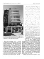
Global Resources Geothermal and hydrothermal energy • 505
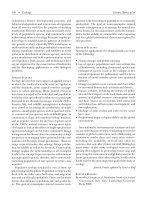
Geothermal steam is funneled through the pipes in the foreground from the geyserdrilling station in the background atthis Northern Califor
-
nia location. (Manny Crisostomo/MCT/Landov)
per kilowatt-hour produced for an atmospheric ex
-
haust unit is about twice that for a condensing unit,
but atmospheric exhaust units are simpler and
cheaper.
The Geysers has one of the largest dry-steam geo-
thermal fields in the world. Steam rises from more
than forty wells. Pipes feed steam to the turbogen-
erators at a temperature of 175° Celsius. Some of the
wells are drilled to depths as great as 2,700 meters.
The geothermal field at Wairakei on North Island of
New Zealand has been a source of electric power for
several decades. The hot water (near 300° Celsius)
rises from more than sixty deep wells. As the pressure
falls, the hot water converts to steam. The flashing of
hot water to steam is the major source of geothermal
energy for electric power production.
Binary plants allow electricity to begeneratedfrom
low- to medium-temperature geothermalresources as
well as from the waste hot water coming from steam/
water separators. Binary plants use a secondary work-
ing fluid. The geothermal fluid heats the secondary
fluid, which is in a closed system. The working fluid is
heated, vaporizes, drives a turbine, is cooled, con-
denses, and is ready to repeat the cycle. Binary plant
technology is becoming the mostcost-effective means
to generate electricity from geothermal resources be-
low 175° Celsius.
In cascaded systems,the output waterfrom onesys-
tem is used as theinputheatsourceto another system.
Such systems allow some of the heat in waste water
from higher temperature systems toberecovered and
used. They are oftenused in conjunctionwith electric
generation facilities to help recover some of the heat
in the wastewater or steam from a turbine.
Space Heating
Space heating by geothermal waters is one ofthemost
common uses of geothermalresources. In some coun-
tries, such as Iceland, entire districts are heated using
the resource. The nature of the geothermal water dic-
tates whether that water is circulated directly in pipes
to homes and other structures or (if the water is too
corrosive) a heat exchanger is used to transfer the
heat to a better fluid for circulation. Hot water in the
range from60°to125°Celsiushasbeenusedforspace
heating with hot-water radiators. Water with as low a
temperature as35° to40° Celsiushas beenused effec-
tively for heating by means of radiant heating, in
which pipes are embedded in the floor or ceiling. An
-
other way of using geothermal energy for heating is
through the circulation of heated air from water-to-air
heat exchangers. Heat pumps are also used with geo-
thermal waters for both heating and cooling.
In district heating, the water to the customer is of-
ten in the 60° to 90° Celsius range and is returned at
35° to 50°Celsius.The distance of thecustomers from
the geothermal resource is important. Transmission
lines of up to 60 kilometers have been used, but
shorter distances are more common and desirable.
When designing a district heating system, the selec-
tion of the area to be supplied, building density, char-
acteristics ofthe heat source, the transmission system,
heat loss in transmission, and heat consumption by
customers are all important factors.
There are more than 550 geothermal wells serving
a variety of uses in Klamath Falls, Oregon. Utiliza-
tion includesheating homes, schools, businesses, and
swimming pools as well as snow-melting systems for
sidewalks and a section of highway pavement. Most of
the eastern side of the city is heated by geothermal
energy. The principal heat extraction system is the
closed-loop downhole heat exchanger utilizing city
water in the heat exchangers. Hot water is delivered
at approximately 82° Celsius and returns at 60° Cel-
sius.
Hot water from springs is delivered through pipes
to heat homesin Reykjavík, Iceland, andseveraloutly-
ing communities. This is the source of heating for 95
percent of the buildings in Reykjavík. Hot water is de-
livered to homes at88° Celsius. The geothermal water
is also used for heating schools, swimming pools, and
greenhouses and is used for aquaculture.
Greenhouse Heating
Using geothermal resources to heat greenhouses is
similar to using it to heat homes and other buildings.
The objective in this case is to provide a thermal envi-
ronment in the greenhouse so that vegetables, flow-
ers, and fruits can be grown out of season. The green-
house is supplied with heated water, and through the
use of radiators, embedded pipes, aerial pipes, or sur-
face pipes, the heat is transferred to the greenhouse
environment. Forced air through heat exchangers is
also used. The United States, Hungary, Italy, and
France all have considerable numbers of geothermal
greenhouses.
Aquaculture
One of the major areas for the direct use of geother
-
mal resources is in aquaculture. The main idea is to
506 • Geothermal and hydrothermal energy Global Resources
adjust the temperature of the water environment in
a production pond so that freshwater or marine fish,
shrimp, and plants have greater growth rates and
thus reach harvest age more quickly. There are many
schemes to regulate the temperature of the pond
water. For supply wells where the geothermal water is
near the required temperature, the water is intro-
duced directly into the pond. For locations having a
well-water temperature too high, the water is spread
in a holding pool where evaporative cooling, radia-
tion, and conductiveheatloss to the ground can allbe
used to reduce the temperature to a level in which it
can be added to the main production pond.
Industrial Applications
The Tasman Pulp and Paper Company, located in
Kawerau, NewZealand, is one of thelargest industrial
developments to utilize geothermal energy. Geother-
mal exploration started there in 1952; it was directed
toward locating anddevelopinga geothermal resource
for a pulp and paper mill. In 1985, the company was
using four wells to supply steam to the operations.
The steam is used to operate log kickers directly,
to dry timber, to generate clean steam, and to drive
an electricity generator. Geothermal energy supplies
about 30 percent of the total process steam and 4 per-
cent of the electricity for the plant. Geothermal en-
ergy in the form of steam is used to dry diatomaceous
earth in Námafjall, Iceland. The diatomaceous earth
is dredgedfromthebottomofalakeandpumped3ki-
lometers by pipeline to a plant where it is dried.
Numerous other industrial applications of geo-
thermal resources exist in the world. These range
from timber drying in Japan to salt production from
evaporating seawater in the Philippines, vegetable
drying in Nevada, alfalfa drying in New Zealand, and
mushroom growing in Oregon.
Environmental Impact
The environmental impacts associated with the use
or conversion of geothermal resources are typically
much less than those associated with the use or con-
version of other energy sources. The resource is often
promoted asa clean technology without the potential
radiation problems associated with nuclear energy fa-
cilities or the atmospheric emissions problems often
associated with oil and coal electric plants. Nonethe-
less, although associated environmental problems are
low, there are some present. In the exploration and
development phases of large-scale geothermal devel
-
opments, access roads and platforms for drill rigs
must bebuilt. The drilling of a well can result in possi-
ble mixing of drilling fluids with the aquifers inter-
sected by the well if the well is not well-cased.Blowouts
can also pollute the groundwater. The drilling fluids
need to be stored and handled as wastes.
Geothermal fluids often contain dissolved gases
such as carbon dioxide, hydrogen sulfide, and meth-
ane. Other chemicals, such as sodium chloride, bo-
ron, arsenic, and mercury, mayalsobe associated with
the geothermal water. The presence of these gases
and chemicals must be determined, and appropriate
means must be selected to prevent their release into
the environment. In some cases this problem is re-
duced by the re-injection of wastewater into the geo-
thermal reservoir.
The release of thermal water into a surface water
body such as a stream, pond, or lake can cause severe
ecosystem damage by changing the ambient water
temperature, even if only by a few degrees. Any dis-
charge ofhot water from thegeothermal siteneeds to
involve a means of cooling the water to an acceptable
level—one that will notcauseenvironmentaldamage.
This result is often achieved through the use of hold-
ing ponds or evaporative cooling. The removal of
large volumes of geothermal fluid from the subsur-
face can cause land subsidence. This is irreversible
and can cause major structural damage. Subsidence
can be prevented by the re-injection of a volume of
fluid equal to that removed.
Noise pollution is one of the potential problems
with geothermal sites where electricity generation is
conducted. Noise reduction can require costly mea-
sures. Because many geothermal electric generation
sites are rural, however, this is often not a problem.
The noise generated in direct heat applications is typi-
cally low.
Economics
The initial cost of a geothermal plant is usually higher
than the initial cost of a similar plant run on conven-
tional fuel. On the other hand, the cost of the energy
for operating a geothermal plant is much lower than
the cost of conventional fuels. In order to be economi-
cally superior, the geothermal plant needs to operate
long enough to at least make up for the difference in
initial cost.
Cascaded systems can be used to optimize the re
-
covery of heat from the geothermal water and steam
and therefore to decrease the overall costs. Systems
Global Resources Geothermal and hydrothermal energy • 507