Data Mining and Knowledge Discovery Handbook, 2 Edition part 87 potx
Bạn đang xem bản rút gọn của tài liệu. Xem và tải ngay bản đầy đủ của tài liệu tại đây (300.05 KB, 10 trang )
840 Shashi Shekhar, Pusheng Zhang, and Yan Huang
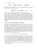
One of the fundamental assumptions of statistical analysis is that the data sam-
ples are independently generated: like successive tosses of coin, or the rolling of a
die. However, in the analysis of spatial data, the assumption about the independence
of samples is generally false. In fact, spatial data tends to be highly self correlated.
For example, people with similar characteristics, occupation and background tend
to cluster together in the same neighborhoods. The economies of a region tend to
be similar. Changes in natural resources, wildlife, and temperature vary gradually
over space. The property of like things to cluster in space is so fundamental that
geographers have elevated it to the status of the first law of geography: “Every-
thing is related to everything else but nearby things are more related than distant
things” (Tobler, 1979). In spatial statistics, an area within statistics devoted to the
analysis of spatial data, this property is called spatial autocorrelation. For example,
Figure 43.1 shows the value distributions of an attribute in a spatial framework for
an independent identical distribution and a distribution with spatial autocorrelation.
Knowledge discovery techniques which ignore spatial autocorrelation typically
perform poorly in the presence of spatial data. Often the spatial dependencies arise
due to the inherent characteristics of the phenomena under study, but in particular
they arise due to the fact that the spatial resolution of imaging sensors are finer than
the size of the object being observed. For example, remote sensing satellites have res-
olutions ranging from 30 meters (e.g., the Enhanced Thematic Mapper of the Landsat
7 satellite of NASA) to one meter (e.g., the IKONOS satellite from SpaceImaging),
while the objects under study (e.g., Urban, Forest, Water) are often much larger than
30 meters. As a result, per-pixel-based classifiers, which do not take spatial con-
text into account, often produce classified images with salt and pepper noise. These
classifiers also suffer in terms of classification accuracy.
The spatial relationship among locations in a spatial framework is of-
ten modeled via a contiguity matrix. A simple contiguity matrix may repre-
sent a neighborhood relationship defined using adjacency, Euclidean distance,
etc. Example definitions of neighborhood using adjacency include a four-
neighborhood and an eight-neighborhood. Given a gridded spatial framework, a four-
neighborhood assumes that a pair of locations influence each other if they share an
edge. An eight-neighborhood assumes that a pair of locations influence each other if
they share either an edge or a vertex.
AB
CD
(a) Spatial Framework
00
00
A
B
C
D
ABCD
110
1
1
0
00
001
110
0A
B
C
D
ABCD
0.5 0.5
0.5 0.5
0.5 0.5
0.5 0.5
00
00
(b) Neighbor relationship (c) Contiguity Matrix
1
Fig. 43.2. A Spatial Framework and Its Four-neighborhood Contiguity Matrix.
43 Spatial Data Mining 841
Figure 43.2(a) shows a gridded spatial framework with four locations, A, B, C,
and D. A binary matrix representation of a four-neighborhood relationship is shown
in Figure 43.2(b). The row-normalized representation of this matrix is called a conti-
guity matrix, as shown in Figure 43.2(c). Other contiguity matrices can be designed
to model neighborhood relationships based on distance. The essential idea is to spec-
ify the pairs of locations that influence each other along with the relative intensity
of interaction. More general models of spatial relationships using cliques and hyper-
graphs are available in the literature (Warrender and Augusteijn, 1999). In spatial
statistics, spatial autocorrelation is quantified using measures such as Ripley’s K-
function and Moran’s I (Cressie, 1993).
In the rest of the chapter, we present case studies of the discovering four im-
portant patterns for spatial Data Mining: spatial outliers, spatial co-location rules,
predictive models, and spatial clusters.
43.3 Spatial Outliers
Outliers have been informally defined as observations in a dataset which appear to
be inconsistent with the remainder of that set of data (Barnett and Lewis, 1994),
or which deviate so much from other observations so as to arouse suspicions that
they were generated by a different mechanism (Hawkins, 1980). The identification
of global outliers can lead to the discovery of unexpected knowledge and has a num-
ber of practical applications in areas such as credit card fraud, athlete performance
analysis, voting irregularity, and severe weather prediction. This section focuses on
spatial outliers, i.e., observations which appear to be inconsistent with their neigh-
borhoods. Detecting spatial outliers is useful in many applications of geographic
information systems and spatial databases, including transportation, ecology, public
safety, public health, climatology, and location-based services.
A spatial outlier is a spatially referenced object whose non-spatial attribute val-
ues differ significantly from those of other spatially referenced objects in its spatial
neighborhood. Informally, a spatial outlier is a local instability (in values of non-
spatial attributes) or a spatially referenced object whose non-spatial attributes are
extreme relative to its neighbors, even though the attributes may not be significantly
different from the entire population. For example, a new house in an old neighbor-
hood of a growing metropolitan area is a spatial outlier based on the non-spatial
attribute house age.
Illustrative Examples We use an example to illustrate the differences among
global and spatial outlier detection methods. In Figure 43.3(a), the X-axis is the lo-
cation of data points in one-dimensional space; the Y-axis is the attribute value for
each data point. Global outlier detection methods ignore the spatial location of each
data point and fit the distribution model to the values of the non-spatial attribute. The
outlier detected using this approach is the data point G, which has an extremely high
attribute value 7.9, exceeding the threshold of
μ
+ 2
σ
= 4.49 +2 ∗1.61 = 7.71, as
shown in Figure 43.3(b). This test assumes a normal distribution for attribute val-
842 Shashi Shekhar, Pusheng Zhang, and Yan Huang
ues. On the other hand, S is a spatial outlier whose observed value is significantly
different than its neighbors P and Q.
0 2 4 6 8 10 12 14 16 18 20
0
1
2
3
4
5
6
7
8
← S
P →
Q →
D ↑
Original Data Points
Location
Attribute Values
Data Point
Fitting Curve
G
L
(a) An Example Dataset
−2 0 2 4 6 8 10
0
1
2
3
4
5
6
7
8
9
Histogram of Attribute Values
Attribute Values
Number of Occurrence
μ−2σ →← μ + 2σ
(b) Histogram
Fig. 43.3. A Dataset for Outlier Detection.
Tests for Detecting Spatial Outliers Tests to detect spatial outliers separate
spatial attributes from non-spatial attributes. Spatial attributes are used to character-
ize location, neighborhood, and distance. Non-spatial attribute dimensions are used
to compare a spatially referenced object to its neighbors. Spatial statistics litera-
ture provides two kinds of bi-partite multidimensional tests, namely graphical tests
and quantitative tests. Graphical tests, which are based on the visualization of spa-
tial data, highlight spatial outliers. Example methods include variogram clouds and
Moran scatterplots. Quantitative methods provide a precise test to distinguish spatial
outliers from the remainder of data. Scatterplots (Anselin, 1994) are a representative
technique from the quantitative family.
A variogram-cloud (Cressie, 1993) displays data points related by neighborhood
relationships. For each pair of locations, the square-root of the absolute difference
between attribute values at the locations versus the Euclidean distance between the
locations are plotted. In datasets exhibiting strong spatial dependence, the variance
in the attribute differences will increase with increasing distance between locations.
Locations that are near to one another, but with large attribute differences, might in-
dicate a spatial outlier, even though the values at both locations may appear to be
reasonable when examining the dataset non-spatially. Figure 43.4(a) shows a vari-
ogram cloud for the example dataset shown in Figure 43.3(a). This plot shows that
two pairs (P,S) and (Q, S) on the left hand side lie above the main group of pairs,
and are possibly related to spatial outliers. The point S may be identified as a spa-
tial outlier since it occurs in both pairs (Q,S) and (P,S). However, graphical tests of
spatial outlier detection are limited by the lack of precise criteria to distinguish spa-
tial outliers. In addition, a variogram cloud requires non-trivial post-processing of
43 Spatial Data Mining 843
highlighted pairs to separate spatial outliers from their neighbors, particularly when
multiple outliers are present, or density varies greatly.
0 0.5 1 1.5 2 2.5 3 3.5
0
0.5
1
1.5
2
2.5
Variogram Cloud
Pairwise Distance
Square Root of Absolute Difference of Attribute Values
← (Q,S)
← (P,S)
(a) Variogram cloud
−2 −1.5 −1 −0.5 0 0.5 1 1.5 2 2.5
−3
−2
−1
0
1
2
3
S →
P →
Q →
Moran Scatter Plot
Z−Score of Attribute Values
Weighted Neighbor Z−Score of Attribute Values
(b) Moran scatterplot
Fig. 43.4. Variogram Cloud and Moran Scatterplot to Detect Spatial Outliers.
A Moran scatterplot (Anselin, 1995) is a plot of normalized attribute value
(Z[ f (i)] =
f (i)−
μ
f
σ
f
) against the neighborhood average of normalized attribute values
(W · Z), where W is the row-normalized (i.e.,
∑
j
W
ij
= 1) neighborhood matrix,
(i.e., W
ij
> 0 iff neighbor(i, j)). The upper left and lower right quadrants of Fig-
ure 43.4(b) indicate a spatial association of dissimilar values: low values surrounded
by high value neighbors(e.g., points P and Q), and high values surrounded by low
values (e.g,. point S). Thus we can identify points(nodes) that are surrounded by
unusually high or low value neighbors. These points can be treated as spatial outliers.
A scatterplot (Anselin, 1994) shows attribute values on the X-axis and the aver-
age of the attribute values in the neighborhood on the Y-axis. A least square regres-
sion line is used to identify spatial outliers. A scatter sloping upward to the right indi-
cates a positive spatial autocorrelation (adjacent values tend to be similar); a scatter
sloping upward to the left indicates a negative spatial autocorrelation. The residual
is defined as the vertical distance (Y-axis) between a point P with location (X
p
,Y
p
)
to the regression line Y = mX + b, that is, residual
ε
= Y
p
−(mX
p
+ b). Cases with
standardized residuals,
ε
standard
=
ε
−
μ
ε
σ
ε
, greater than 3.0 or less than -3.0 are flagged
as possible spatial outliers, where
μ
ε
and
σ
ε
are the mean and standard deviation of
the distribution of the error term
ε
. In Figure 43.5(a), a scatterplot shows the attribute
values plotted against the average of the attribute values in neighboring areas for the
dataset in Figure 43.3(a). The point S turns out to be the farthest from the regression
line and may be identified as a spatial outlier.
A location (sensor) is compared to its neighborhood using the function S(x)=
[ f (x)−E
y∈N(x)
( f (y))], where f (x) is the attribute value for a location x, N(x) is the
844 Shashi Shekhar, Pusheng Zhang, and Yan Huang
set of neighbors of x, and E
y∈N(x)
( f (y)) is the average attribute value for the neigh-
bors of x (Shekhar et al., 2003). The statistic function S(x) denotes the difference
of the attribute value of a sensor located at x and the average attribute value of x
s
neighbors.
Spatial statistic S(x) is normally distributed if the attribute value f (x) is normally
distributed. A popular test for detecting spatial outliers for normally distributed f (x)
can be described as follows: Spatial statistic Z
s(x)
= |
S(x)−
μ
s
σ
s
| >
θ
. For each location
x with an attribute value f (x), the S(x) is the difference between the attribute value
at location x and the average attribute value of x
s neighbors,
μ
s
is the mean value
of S(x), and
σ
s
is the value of the standard deviation of S(x) over all stations. The
choice of
θ
depends on a specified confidence level. For example, a confidence level
of 95 percent will lead to
θ
≈ 2.
Figure 43.5(b) shows the visualization of the spatial statistic method described
above. The X-axis is the location of data points in one-dimensional space; the Y -axis
is the value of spatial statistic Z
s(x)
for each data point. We can easily observe that
point S has a Z
s(x)
value exceeding 3, and will be detected as a spatial outlier. Note
that the two neighboring points P and Q of S have Z
s(x)
values close to -2 due to the
presence of spatial outliers in their neighborhoods.
1 2 3 4 5 6 7 8
2
2.5
3
3.5
4
4.5
5
5.5
6
6.5
7
Scatter Plot
Attribute Values
Average Attribute Values Over Neighborhood
← S
P →
Q →
(a) Scatterplot
0 2 4 6 8 10 12 14 16 18 20
−2
−1
0
1
2
3
4
Spatial Statistic Zs(x) Test
Location
Zs(x)
S →
P →
← Q
(b) Spatial statistic Z
s(x)
Fig. 43.5. Scatterplot and Spatial Statistic Z
s(x)
to Detect Spatial Outliers.
43 Spatial Data Mining 845
43.4 Spatial Co-location Rules
Spatial co-location patterns represent subsets of boolean spatial features whose in-
stances are often located in close geographic proximity. Examples include symbiotic
species, e.g., the Nile Crocodile and Egyptian Plover in ecology and frontage-roads
and highways in metropolitan road maps. Boolean spatial features describe the pres-
ence or absence of geographic object types at different locations in a two dimensional
or three dimensional metric space, e.g., surface of the Earth. Examples of boolean
spatial features include plant species, animal species, disease, crime, business types,
climate disturbances, etc.
0 10 20 30 40 50 60 70 80
0
10
20
30
40
50
60
70
80
Co−location Patterns − Sample Data
X
Y
0 2 4 6 8 10
0
200
400
600
800
1000
Distance h
Cross−K function
Cross−K function of pairs of spatial features
y=pi*h
2
o and *
x and +
* and x
* and +
Fig. 43.6. a) A spatial dataset. Shapes represent different spatial feature types. b) Spatial fea-
tures in sets {‘+’, ‘×’} and {‘o’, ‘*’} are co-located in (a) as shown by Ripley’s K function
Spatial co-location rules are models to infer the presence of boolean spatial fea-
tures in the neighborhood of instances of other boolean spatial features. For example,
“Nile Crocodiles → Egyptian Plover” predicts the presence of Egyptian Plover birds
in areas with Nile Crocodiles. Figure 43.6(a) shows a dataset consisting of instances
of several boolean spatial features, each represented by a distinct shape. A careful
visual review reveals two prevalent co-location patterns, i.e., (‘+’,‘×’) and (‘o’,‘*’).
These co-location patterns are also identified via a spatial statistical interest measure,
namely Ripley’s K function (Ripley, 1977). This interest measure has a value of
π
h
2
for a co-location pattern with a pair of spatial independent features for a given dis-
tance h. The co-location patterns (‘+’,‘×’) and (‘o’,‘*’) have much higher values of
this interest measure relative to that of an independent pair illustrated in Figure 43.6
(b). Also note that we will refer to Ripley’s K function as the K function in the rest
of the chapter for simplicity.
Spatial co-location rule discovery is a process to identify co-location patterns
from spatial datasets of instances of a number of boolean features. It is not trivial to
adapt association rule mining algorithms to mine co-location patterns since instances
of spatial features are embedded in a continuous space and share a variety of spatial
846 Shashi Shekhar, Pusheng Zhang, and Yan Huang
relations. Reusing association rule algorithm may require transactionizing spatial
datasets, which is challenging due to the risk of transaction boundaries splitting co-
location pattern instances across distinct transactions as illustrated in Figure 43.7,
which uses cells of a rectangular grid to define transactions. Transaction boundaries
split many instances of (‘+’,‘×’) and (‘o’,‘*’), which are highlighted using ellipses.
Transaction-based association rule mining algorithms need to be extended to cor-
rectly and completely identify co-locations defined by interest measures, such as the
K function, whose values may be adversely affected by the split instances.
0 10 20 30 40 50 60 70 80
0
10
20
30
40
50
60
70
80
Co−location Patterns − Sample Data
X
Y
Fig. 43.7. Transactions split circled instances of co-location patterns
Approaches to discovering spatial co-location rules in the literature can be cat-
egorized into two classes, namely spatial statistics and association rules. In spatial
statistics, interest measures such as the K function (Ripley, 1977) (and variations
such as the L function (Cressie, 1993) and G function (Cressie, 1993)), mean nearest-
neighbor distance, and quadrat count analysis (Cressie, 1993) are used to identify
co-located spatial feature types. The K function for a pair of spatial features is de-
fined as follows: K
ij
(h)=
λ
−1
j
E [number of type j event within distance h of a
randomly chosen type i event], where
λ
j
is the density (number per unit area) of
event j and h is the distance. Without edge effects, the K-function could be esti-
mated by:
ˆ
K
ij
(h)=
1
λ
i
λ
j
W
∑
k
∑
l
I
h
(d(i
k
, j
l
)), where d(i
k
, j
l
) is the distance between
the k’th location of type i and the l’th location of type j, I
h
is the indicator function
assuming value 1 if d(i, j) ≤h, and value 0 otherwise, and W is the area of the study
region.
λ
j
×
ˆ
K
ij
(h) estimates the expected number of type j event instances within
distance h of a type i event. The value of
π
h
2
is expected for a pair of independent
pair of spatial features. The variance of the K function can be estimated by Monte
Carlo simulation (Cressie, 1993) in general and by a close form equation under spe-
cial circumstances (Cressie, 1993). Pointwise confidence intervals, e.g., 95%, can be
estimated by simulating many realizations of the spatial patterns. The critical val-
ues for a test of independence could be calculated accordingly. In Figure 43.6 (b),
43 Spatial Data Mining 847
the K functions of the two pairs of spatial features, i.e., {‘+’,‘x’} and {‘o’,‘*’}, are
well above the y =
π
∗h
2
while the K functions of the other random two pairs of
spatial features, i.e., {‘*’,‘x’} and {‘*’,‘+’}, are very close to complete spatial inde-
pendence. This figure does not show the confidence band. We are not aware of the
definition of the K function for subsets with 3 or more spatial features. Even if the
definition is generalized, computing spatial correlation measures for all possible co-
location patterns can be computationally expensive due to the exponential number of
candidate subsets given a large collection of spatial boolean features.
Data Mining approaches to spatial co-location mining can be broadly divided
into transaction-based and spatial join-based approaches. The transaction based ap-
proaches focus on the creation of transactions over space so that an association
rule mining algorithm (Agrawal and Srikant, 1994) can be used. Transactions over
space have been defined by a reference-feature centric model (Koperski and Han,
1995) or a data-partition (Morimoto, 2001) approach. In the reference feature cen-
tric model (Koperski and Han, 1995), transactions are created around instances of
a special user-specified spatial feature. The association rules are derived using the
apriori (Agrawal and Srikant, 1994) algorithm. The rules found are all related to the
reference feature. Generalizing this paradigm to the case where no reference feature
is specified is non-trivial. Defining transactions around locations of instances of all
features may yield duplicate counts for many candidate associations. Transactions in
the data-partition approach (Morimoto, 2001) are formulated via grouping the spa-
tial instances into disjoint partitions using different partitioning methods, which may
yield distinct sets of transactions, which in turn yields different values of support
of the co-location. Occasionally, imposing artificial disjoint transactions via space
partitioning may undercount instances of tuples intersecting the boundaries of arti-
ficial transactions. In addition, to the best of our knowledge, no previous study has
identified the relationship between transaction-based interest measures(e.g., support
and confidence) (Agrawal and Srikant, 1994) and commonly used spatial interest
measures(e.g., K function).
Spatial join-based approaches work directly with spatial data and include the
cluster-then-overlay approaches (Estivill-Castro and Murray, 1998, Estivill-Castro
and Lee, 2001) and instance join-based approach (Shekhar and Huang, 2001). The
former treats every spatial attribute as a map layer and first identifies spatial clusters
of instance data in each layer. Given X and Y as sets of layers, a clustered spatial
association rule is defined as X ⇒Y (CS,CC%), for X
Y =/0, where CS is the clus-
tered support, defined as the ratio of the area of the cluster (region) that satisfies both
X and Y to the total area of the study region S, and CC% is the clustered confidence,
which can be interpreted as CC% of areas of clusters (regions) of X intersect with
areas of clusters(regions) of Y . The value of interest measures, e.g., clustered sup-
port and clustered confidence, depend on the choice of clustering algorithms from a
large collection of choices (Han et al., 2001). To our knowledge, the relationship be-
tween these interest measures and commonly used spatial statistical measures(e.g.,
K function) is not yet established. In recent work (Huang et al., 2004), an instance
join-based approach was proposed that uses join selectivity as the prevalence inter-
848 Shashi Shekhar, Pusheng Zhang, and Yan Huang
est measures and provided interpretation models by relating those to other interest
measures, e.g., K function.
43.5 Predictive Models
The prediction of events occurring at particular geographic locations is very impor-
tant in several application domains. Examples of problems which require location
prediction include crime analysis, cellular networking, and natural disasters such as
fires, floods, droughts, vegetation diseases, and earthquakes. In this section we pro-
vide two spatial Data Mining techniques for predicting locations, namely the Spatial
Autoregressive Model (SAR) and Markov Random Fields (MRF).
An Application Domain We begin by introducing an example to illustrate the
different concepts related to location prediction in spatial Data Mining. We are given
data about two wetlands, named Darr and Stubble, on the shores of Lake Erie in
Ohio USA in order to predict the spatial distribution of a marsh-breeding bird, the
red-winged blackbird (Agelaius phoeniceus). The data was collected from April to
June in two successive years, 1995 and 1996.
A uniform grid was imposed on the two wetlands and different types of measure-
ments were recorded at each cell or pixel. In total, the values of seven attributes were
recorded at each cell. Domain knowledge is crucial in deciding which attributes are
important and which are not. For example, Vegetation Durability was chosen over
Vegetation Species because specialized knowledge about the bird-nesting habits of
the red-winged blackbird suggested that the choice of nest location is more depen-
dent on plant structure, plant resistance to wind, and wave action than on the plant
species.
An important goal is to build a model for predicting the location of bird nests
in the wetlands. Typically, the model is built using a portion of the data, called the
learning or training data, and then tested on the remainder of the data, called the
testing data. In this study we build a model using the 1995 Darr wetland data and
then tested it 1995 Stubble wetland data. In the learning data, all the attributes are
used to build the model and in the training data, one value is hidden, in our case the
location of the nests. Using knowledge gained from the 1995 Darr data and the value
of the independent attributes in the test data, we want to predict the location of the
nests in 1995 Stubble data.
Modeling Spatial Dependencies Using the SAR and MRF Models Several
previous studies (Jhung and Swain, 1996), (Solberg et al., 1996) have shown that
the modeling of spatial dependency (often called context) during the classification
process improves overall classification accuracy. Spatial context can be defined by
the relationships between spatially adjacent pixels in a small neighborhood. In this
section, we present two models to model spatial dependency: the spatial autoregres-
sive model(SAR) and Markov random field(MRF)-based Bayesian classifiers.
Spatial Autoregressive Model The spatial autoregressive model decomposes a
classifier
ˆ
f
C
into two parts, namely spatial autoregression and logistic transformation.
We first show how spatial dependencies are modeled using the framework of logistic
43 Spatial Data Mining 849
(a) Nest Locations
0 20 40 60 80 100 120 140 160
0
10
20
30
40
50
60
70
80
nz = 5372
Vegetation distribution across the wetland
(b) Vegetation Durability
0 20 40 60 80 100 120 140 160
0
10
20
30
40
50
60
70
80
nz = 5372
Water depth variation across wetland
(c) Water Depth
0 20 40 60 80 100 120 140 160
0
10
20
30
40
50
60
70
80
nz = 5372
Distance to open water
(d) Distance to Open Water
Fig. 43.8. (a) Learning dataset: The geometry of the Darr wetland and the locations of the
nests, (b) The spatial distribution of vegetation durability over the marshland, (c) The spatial
distribution of water depth, and (d) The spatial distribution of distance to open water.
regression analysis. In the spatial autoregression model, the spatial dependencies of
the error term, or, the dependent variable, are directly modeled in the regression
equation (Anselin, 1988). If the dependent values y
i
are related to each other, then
the regression equation can be modified as
y =
ρ
Wy+ X
β
+
ε
. (43.1)
Here W is the neighborhood relationship contiguity matrix and
ρ
is a parameter
that reflects the strength of the spatial dependencies between the elements of the
dependent variable. After the correction term
ρ
Wy is introduced, the components of
the residual error vector
ε
are then assumed to be generated from independent and
identical standard normal distributions. As in the case of classical regression, the
SAR equation has to be transformed via the logistic function for binary dependent
variables.
We refer to this equation as the Spatial Autoregressive Model (SAR). Notice that
when
ρ
= 0, this equation collapses to the classical regression model. The benefits