Data Mining and Knowledge Discovery Handbook, 2 Edition part 88 ppt
Bạn đang xem bản rút gọn của tài liệu. Xem và tải ngay bản đầy đủ của tài liệu tại đây (393.56 KB, 10 trang )
850 Shashi Shekhar, Pusheng Zhang, and Yan Huang
of modeling spatial autocorrelation are many: The residual error will have much
lower spatial autocorrelation (i.e., systematic variation). With the proper choice of
W , the residual error should, at least theoretically, have no systematic variation. If the
spatial autocorrelation coefficient is statistically significant, then SAR will quantify
the presence of spatial autocorrelation. It will indicate the extent to which variations
in the dependent variable (y) are explained by the average of neighboring observation
values. Finally, the model will have a better fit, (i.e., a higher R-squared statistic).
Markov Random Field-based Bayesian Classifiers Markov random field-
based Bayesian classifiers estimate the classification model
ˆ
f
C
using MRF and
Bayes’ rule. A set of random variables whose interdependency relationship is rep-
resented by an undirected graph (i.e., a symmetric neighborhood matrix) is called
a Markov Random Field (Li, 1995). The Markov property specifies that a variable
depends only on its neighbors and is independent of all other variables. The location
prediction problem can be modeled in this framework by assuming that the class la-
bel, l
i
= f
C
(s
i
), of different locations, s
i
, constitutes an MRF. In other words, random
variable l
i
is independent of l
j
if W (s
i
,s
j
)=0.
The Bayesian rule can be used to predict l
i
from feature value vector X and
neighborhood class label vector L
i
as follows:
Pr(l
i
|X,L
i
)=
Pr(X |l
i
,L
i
)Pr(l
i
|L
i
)
Pr(X )
(43.2)
The solution procedure can estimate Pr(l
i
|L
i
) from the training data, where L
i
denotes a set of labels in the neighborhood of s
i
excluding the label at s
i
, by exam-
ining the ratios of the frequencies of class labels to the total number of locations in
the spatial framework. Pr(X|l
i
,L
i
) can be estimated using kernel functions from the
observed values in the training dataset. For reliable estimates, even larger training
datasets are needed relative to those needed for the Bayesian classifiers without spa-
tial context, since we are estimating a more complex distribution. An assumption on
Pr(X |l
i
,L
i
) may be useful if the training dataset available is not large enough. A com-
mon assumption is the uniformity of influence from all neighbors of a location. For
computational efficiency it can be assumed that only local explanatory data X(s
i
) and
neighborhood label L
i
are relevant in predicting class label l
i
= f
C
(s
i
). It is common
to assume that all interaction between neighbors is captured via the interaction in the
class label variable. Many domains also use specific parametric probability distribu-
tion forms, leading to simpler solution procedures. In addition, it is frequently easier
to work with a Gibbs distribution specialized by the locally defined MRF through
the Hammersley-Clifford theorem (Besag, 1974).
A more detailed theoretical and experimental comparison of these methods can
be found in (Shekhar et al., 2002). Although MRF and SAR classification have dif-
ferent formulations, they share a common goal, estimating the posterior probability
distribution: p(l
i
|X). However, the posterior for the two models is computed differ-
ently with different assumptions. For MRF the posterior is computed using Bayes’
rule. On the other hand, in logistic regression, the posterior distribution is directly fit
to the data. One important difference between logistic regression and MRF is that lo-
gistic regression assumes no dependence on neighboring classes. Logistic regression
43 Spatial Data Mining 851
and logistic SAR models belong to a more general exponential family. The exponen-
tial family is given by Pr(u|v)=e
A(
θ
v
)+B(u,
π
)+
θ
T
v
u
where u,v are location and label
respectively. This exponential family includes many of the common distributions
such as Gaussian, Binomial, Bernoulli, and Poisson as special cases.
Experiments were carried out on the Darr and Stubble wetlands to compare clas-
sical regression, SAR, and the MRF-based Bayesian classifiers. The results showed
that the MRF models yield better spatial and classification accuracies over SAR in
the prediction of the locations of bird nests. We also observed that SAR predictions
are extremely localized, missing actual nests over a large part of the marsh lands.
43.6 Spatial Clusters
Spatial clustering is a process of grouping a set of spatial objects into clusters so
that objects within a cluster have high similarity in comparison to one another, but
are dissimilar to objects in other clusters. For example, clustering is used to deter-
mine the “hot spots” in crime analysis and disease tracking. Hot spot analysis is the
process of finding unusually dense event clusters across time and space. Many crim-
inal justice agencies are exploring the benefits provided by computer technologies
to identify crime hot spots in order to take preventive strategies such as deploying
saturation patrols in hot spot areas.
Spatial clustering can be applied to group similar spatial objects together; the
implicit assumption is that patterns in space tend to be grouped rather than randomly
located. However, the statistical significance of spatial clusters should be measured
by testing the assumption in the data. The test is critical before proceeding with any
serious clustering analyses.
Complete Spatial Randomness, Cluster, and Decluster In spatial statistics,
the standard against which spatial point patterns are often compared is a completely
spatially random point process, and departures indicate that the pattern is not dis-
tributed randomly in space. Complete spatial randomness (CSR) (Cressie, 1993) is
synonymous with a homogeneous Poisson process. The patterns of the process are
independently and uniformly distributed over space, i.e., the patterns are equally
likely to occur anywhere and do not interact with each other. However, patterns gen-
erated by a non-random process can be either cluster patterns(aggregated patterns)
or decluster patterns(uniformly spaced patterns).
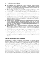
To illustrate, Figure 43.9 shows realizations from a completely spatially random
process, a spatial cluster process, and a spatial decluster process (each conditioned
to have 80 points) in a square. Notice in Figure 43.9 (a) that the complete spatial
randomness pattern seems to exhibit some clustering. This is not an unrepresentive
realization, but illustrates a well-known property of homogeneous Poisson processes:
event-to-nearest-event distances are proportional to
χ
2
2
random variables, whose den-
sities have a substantial amount of probability near zero (Cressie, 1993). Spatial clus-
tering is more statistically significant when the data exhibit a cluster pattern rather
than a CSR pattern or decluster pattern.
852 Shashi Shekhar, Pusheng Zhang, and Yan Huang
(a) CSR Pattern (b) Cluster Pattern (c) Decluster Pattern
Fig. 43.9. Illustration of CSR, Cluster, and Decluster Patterns
Several statistical methods can be applied to quantify deviations of patterns from
a complete spatial randomness point pattern (Cressie, 1993). One type of descriptive
statistics is based on quadrats (i.e., well defined area, often rectangle in shape). Usu-
ally quadrats of random location and orientations in the quadrats are counted, and
statistics derived from the counters are computed. Another type of statistics is based
on distances between patterns; one such type is Ripley’s K-function (Cressie, 1993).
After the verification of the statistical significance of the spatial clustering, clas-
sical clustering algorithms (Han et al., 2001) can be used to discover interesting
clusters.
43.7 Summary
In this chapter, we have focused on the features of spatial data mining that distinguish
it from classical Data Mining. We have discussed major research accomplishments
and techniques in spatial Data Mining, especially those related to four important out-
put patterns: predictive models, spatial outliers, spatial co-location rules, and spatial
clusters.
Acknowledgments
This work was supported in part by the Army High Performance Computing Re-
search Center under the auspices of the Department of the Army, Army Research
Laboratory cooperative agreement number DAAD19-01-2-0014, the content of
which does not necessarily reflect the position or the policy of the government, and
no official endorsement should be inferred.
We are particularly grateful to our collaborators Prof. Vipin Kumar, Prof. Paul
Schrater, Dr. Sanjay Chawla, Dr. Chang-Tien Lu, Dr. Weili Wu, and Prof. Uygar
Ozesmi for their various contributions. We also thank Xiaobin Ma, Hui Xiong, Jin
Soung Yoo, Qingsong Lu, Baris Kazar, and anonymous reviewers for their valuable
feedbacks on early versions of this chapter.
43 Spatial Data Mining 853
References
Agrawal, R. and Srikant, R. (1994). Fast Algorithms for Mining Association Rules. In Proc.
of Very Large Databases.
Anselin, L. (1988). Spatial Econometrics: Methods and Models. Kluwer, Dordrecht, Nether-
lands.
Anselin, L. (1994). Exploratory Spatial Data Analysis and Geographic Information Systems.
In Painho, M., editor, New Tools for Spatial Analysis, pages 45–54.
Anselin, L. (1995). Local Indicators of Spatial Association: LISA. Geographical Analysis,
27(2):93–115.
Barnett, V. and Lewis, T. (1994). Outliers in Statistical Data. John Wiley, 3rd edition edition.
Besag, J. (1974). Spatial Interaction and Statistical Analysis of Lattice Systems. Journal of
Royal Statistical Society: Series B, 36:192–236.
Bolstad, P. (2002). GIS Foundamentals: A Fisrt Text on GIS. Eider Press.
Cressie, N. (1993). Statistics for Spatial Data (Revised Edition). Wiley, New York.
Estivill-Castro, V. and Lee, I. (2001). Data Mining Techniques for Autonomous Exploration
of Large Volumes of Geo-referenced Crime Data. In Proc. of the 6th International Con-
ference on Geocomputation.
Estivill-Castro, V. and Murray, A. (1998). Discovering Associations in Spatial Data - An
Efficient Medoid Based Approach. In Proc. of the Second Pacific-Asia Conference on
Knowledge Discovery and Data Mining.
Han, J., Kamber, M., and Tung, A. (2001). Spatial Clustering Methods in Data Mining: A
Survey. In Miller, H. and Han, J., editors, Geographic Data Mining and Knowledge
Discovery. Taylor and Francis.
Hawkins, D. (1980). Identification of Outliers. Chapman and Hall.
Huang, Y., Shekhar, S., and Xiong, H. (2004). Discovering Co-location Patterns from Spatial
Datasets:A General Approach. IEEE Transactions on Knowledge and Data Engineering,
16(12).
Jain, A. and Dubes, R. (1988). Algorithms for Clustering Data. Prentice Hall.
Jhung, Y. and Swain, P. H. (1996). Bayesian Contextual Classification Based on Modified
M-Estimates and Markov Random Fields. IEEE Transaction on Pattern Analysis and
Machine Intelligence, 34(1):67–75.
Koperski, K. and Han, J. (1995). Discovery of Spatial Association Rules in Geographic
Information Databases. In Proc. Fourth International Symposium on Large Spatial
Databases, Maine. 47-66.
Li, S. (1995). A Markov Random Field Modeling. Computer Vision.
Morimoto, Y. (2001). Mining Frequent Neighboring Class Sets in Spatial
Databases. In Proc. ACM SIGKDD International Conference on Knowledge Dis-
covery and Data Mining.
Quinlan, J. (1993). C4.5: Programs for Machine Learning. Morgan Kaufmann Publishers.
Ripley, B. (1977). Modelling spatial patterns. Journal of the Royal Statistical Society, Series
B 39:172–192.
Roddick, J F. and Spiliopoulou, M. (1999). A Bibliography of Temporal, Spatial and Spatio-
Temporal Data Mining Research. SIGKDD Explorations 1(1): 34-38 (1999).
Shekhar, S. and Chawla, S. (2003). Spatial Databases: A Tour. Prentice Hall (ISBN 0-7484-
0064-6).
Shekhar, S. and Huang, Y. (2001). Co-location Rules Mining: A Summary of Results. In
Proc. of the 7th Int’l Symp. on Spatial and Temporal Databases.
854 Shashi Shekhar, Pusheng Zhang, and Yan Huang
Shekhar, S., Lu, C., and Zhang, P. (2003). A Unified Approach to Detecting Spatial Outliers.
GeoInformatica, 7(2).
Shekhar, S., Schrater, P. R., Vatsavai, R. R., Wu, W., and Chawla, S. (2002). Spatial Contex-
tual Classification and Prediction Models for Mining Geospatial Data. IEEE Transaction
on Multimedia, 4(2).
Solberg, A. H., Taxt, T., and Jain, A. K. (1996). A Markov Random Field Model for Classi-
fication of Multisource Satellite Imagery. IEEE Transaction on Geoscience and Remote
Sensing, 34(1):100–113.
Tobler, W. (1979). Cellular Geography, Philosophy in Geography. Gale and Olsson, Eds.,
Dordrecht, Reidel.
Warrender, C. E. and Augusteijn, M. F. (1999). Fusion of image classifications using
Bayesian techniques with Markov rand fields. International Journal of Remote Sens-
ing, 20(10):1987–2002.
44
Spatio-temporal clustering
Slava Kisilevich, Florian Mansmann, Mirco Nanni, Salvatore Rinzivillo
1
University of Konstanz, Germany,
2
University of Konstanz, Germany
3
University of Pisa, Italy,
4
Institute of Information Science and Technologies, Italy,
Summary. Spatio-temporal clustering is a process of grouping objects based on their spa-
tial and temporal similarity. It is relatively new subfield of data mining which gained high
popularity especially in geographic information sciences due to the pervasiveness of all kinds
of location-based or environmental devices that record position, time or/and environmental
properties of an object or set of objects in real-time. As a consequence, different types and
large amounts of spatio-temporal data became available that introduce new challenges to data
analysis and require novel approaches to knowledge discovery. In this chapter we concentrate
on the spatio-temporal clustering in geographic space. First, we provide a classification of dif-
ferent types of spatio-temporal data. Then, we focus on one type of spatio-temporal clustering
- trajectory clustering, provide an overview of the state-of-the-art approaches and methods
of spatio-temporal clustering and finally present several scenarios in different application do-
mains such as movement, cellular networks and environmental studies.
44.1 Introduction
Geographic and temporal properties are a key aspect of many data analysis problems in busi-
ness, government, and science. Through the availability of cheap sensor devices we have wit-
nessed an exponential growth of geo-tagged data in the last few years resulting in the availabil-
ity of fine-grained geographic data at small temporal sampling intervals. Therefore, the actual
challenge in geo-temporal analysis is moving from acquiring the right data towards large-scale
analysis of the available data.
Clustering is one approach to analyze geo-temporal data at a higher level of abstraction by
grouping the data according to its similarity into meaningful clusters. While the two dimen-
sional geographic dimensions are relatively manageable, their combination with time results
in a number of challenges. It is mostly application dependent how the weight of the time di-
mension should be considered in a distance metric. When tracking pedestrians, for example,
two geographically close sample points co-occurring within a minute interval could belong to
the same cluster, whereas two sample points at near distance within a time interval of a few
nanoseconds in a physics experiment might belong to different clusters. In addition to this,
representing temporal information on a map becomes extremely challenging.
When considering a group of points in time as a single entity, more complex data types
such as trajectories emerge. Analysis questions might then deal with the correlation of these
O. Maimon, L. Rokach (eds.), Data Mining and Knowledge Discovery Handbook, 2nd ed.,
DOI 10.1007/978-0-387-09823-4_44, © Springer Science+Business Media, LLC 2010
856 Slava Kisilevich, Florian Mansmann, Mirco Nanni, Salvatore Rinzivillo
trajectories among each others, resulting in extraction of patterns such as important places
from trajectories or clustering of trajectories with common features.
Yet on a higher level, the problem of moving clusters arises. An exemplary analysis ques-
tion might therefore be if there are groups of commuters within a city that move from one
area of the city to another one within a particular time frame. This kind of analysis can give
meaningful hints to city planners in order to avoid regular traffic jams.
The rest of this chapter first details basic concepts of spatio-temporal clustering and then
lists a number of applications for spatio-temporal clustering found in the literature. After-
wards, we identify open issues in spatio-temporal clustering with a high need for future re-
search. Finally, the last section summarizes our view on spatio-temporal clustering.
44.2 Spatio-temporal clustering
Whatever the analysis objective or the computational schema adopted, the clustering task
heavily depends on the specific characteristics of the data considered. In particular, the spatio-
temporal context is a large container, which includes several kinds of data types that exhibit
extremely different properties and offer sensibly different opportunities of extracting useful
knowledge. In this section we provide a taxonomy of the data types that are available in the
spatio-temporal domain, briefly describe each class of data with a few examples taken from
the spatio-temporal clustering literature, and finally report in detail the state-of-art of cluster-
ing methods for a particular kind of data – trajectories – that constitute the main focus of this
chapter.
44.2.1 A classification of spatio-temporal data types
Several different forms of spatio-temporal data types are available in real applications. While
they all share the availability of some kind of spatial and temporal aspects, the extent of such
information and the way they are related can combine to several different kinds of data ob-
jects. Figure 44.1 visually depicts a possible classification of such data types, based on two
dimensions:
• the temporal dimension describes to which extent the evolution of the object is captured
by the data. The very basic case consists of objects that do not evolve at all, in which case
only a static snapshot view of each object is available. In slightly more complex contexts,
each object can change its status, yet only its most recent value (i.e., an updated snapshot)
is known, therefore without any knowledge about its past history. Finally, we can have the
extreme case where the full history of the object is kept, thus forming a time series of the
status it traversed;
• the spatial dimension describes whether the objects considered are associated to a fixed
location (e.g., the information collected by sensors fixed to the ground) or they can move,
i.e., their location is dynamic and can change in time.
In addition to these two dimensions, a third, auxiliary one is mentioned in our classifica-
tion, which is related to the spatial extension of the objects involved. The simplest case, which
is also the most popular in real world case studies, considers point-wise objects, while more
complex cases can take into consideration objects with an extension, such as lines and areas.
In particular, Figure 44.1 focuses on point-wise objects, while their counterparts with spatial
extension are omitted for the sake of presentation.
44 Spatio-temporal clustering 857
Fig. 44.1. Context for ST Clustering
In the following we briefly describe the main classes of data types we obtain for point-wise
objects.
ST events. A very basic example of spatio-temporal information are spatio-temporal events,
such as earth tremors captured by sensors or geo-referenced records of an epidemic. Each
event is usually associated with the location where it was recorded and the correspond-
ing timestamp. Both the spatial and the temporal information associated with the events
are static, since no movement or any other kind of evolution is possible. Finding clusters
among events means to discover groups that lie close both in time and in space, and pos-
sibly share other non-spatial properties. A classical example of that is (Kulldorff(1997))’s
spatial scan statistics, that searches spatio-temporal cylinders (i.e., circular regions con-
sidered within a time interval) where the density of events of the same type is higher than
outside, essentially representing areas where the events occurred consistently for a signifi-
cant amount of time. In some applications, such as epidemiology, such area is expected to
change in size and location, therefore extensions of the basic scan statistics have been pro-
posed that consider shapes different from simple cylinders. For instance, (Iyengar(2004))
introduces (reversed) pyramid shapes, representing a small region (the pinpoint of the
pyramid, e.g. the origin of an epidemic) that grows in time (the enlarging section of the
pyramid, e.g. the progressive outbreak) till reaching its maximal extension (the base of
the pyramid). From another viewpoint, (Wang et al(2006)Wang, Wang, and Li) proposed
two spatio-temporal clustering algorithms (ST-GRID and ST-DBSCAN) for analysis of
sequences of seismic events. ST-GRID is based on partitioning of the spatial and tem-
poral dimensions into cells. ST-DBSCAN is an extension of the DBSCAN algorithm to
handle spatio-temporal clustering. The k-dist graph proposed in (Ester et al(1996)Ester,
858 Slava Kisilevich, Florian Mansmann, Mirco Nanni, Salvatore Rinzivillo
Kriegel, Sander, and Xu) as a heuristic for determination of the input parameters was used
in both approaches. Hence, in the first step, the k-dist graph was created using spatial and
temporal dimensions. By means of the graph, the analyst could infer the suitable thresh-
olds for the spatial and temporal cell lengths. In the second step, the inferred cell lengths
are provided to ST-GRID algorithm as an input and the dense clusters are extracted. ST-
DBSCAN introduced the second parameter of the neighborhood radius in addition to the
spatial neighborhood radius
ε
, namely temporal neighborhood radius
ε
t
. These two pa-
rameters were determined using k-dist graph and provided to ST-DBSCAN as an input.
Thus, point p is considered as core when the number of points in the neighborhood is
greater or equal to the threshold MinPts within spatial and temporal thresholds.
Geo-referenced variables. When it is possible to observe the evolution in time of some phe-
nomena in a fixed location, we have what is usually called a geo-referenced variable,
i.e., the time-changing value of some observed property. In particular, the basic settings
might allow only to remember the most recent value of such variable. In this case, the
clustering task can be seen as very similar to the case of events discussed above, with the
exception that the objects compared refer to the same time instant (the actual time) and
their non-spatial features (variables) are not constant. A typical problem in this context
consists in efficiently computing a clustering that (i) takes into account both the spatial
and non-spatial features, and (ii) exploits the clusters found at the previous time stamp,
therefore trying to detect the relevant changes in the data and incrementally update the
clusters, rather than computing them from scratch.
Geo-referenced time series. In a more sophisticated situation, it might be possible to store
the whole history of the evolving object, therefore providing a (geo-referenced) time-
series for the measured variables. When several variables are available, they are usually
seen as a single, multidimensional time series. In this case, clustering a set of objects
requires to compare the way their time series evolve and to relate that to their spatial
position. A classical problem consists in detecting the correlations (and therefore form-
ing clusters) among different time series trying to filter out the effects of spatial auto-
correlation, i.e., the mutual interference between objects due to their spatial proximity,
e.g., (Zhang et al(2003)Zhang, Huang, Shekhar, and Kumar). Moreover, spatio-temporal
data in the form of sequences of images (e.g., fields describing pressure and ground tem-
perature, remotely sensed from satellites) can be seen as a particular case where location
points are regularly distributed in space along a grid.
Moving objects. When (also) the spatial location of the data object is time-changing, we are
dealing with moving objects. In the simplest case, the available information about such
objects consists in their most recent position, as in the context of real-time monitoring
of vehicles for security applications, and no trace of the past locations is kept. As in the
case of geo-referenced variables, a typical clustering problem in this context consists in
keeping an up-to-date set of clusters through incremental update from previous results,
trying to detect the recent changes in the data (in particular, their recent movements) that
were significant or that are likely to be followed by large changes in the close future,
e.g., due to a change of heading of the object. An example is provided by the work in (Li
et al(2004a)Li, Han, and Yang), where a micro-clustering technique based on direction
and speed of objects is applied to achieve a large scalability.
Trajectories. When the whole history of a moving object is stored and available for analysis,
the sequence of spatial locations visited by the object, together with the time-stamps of
such visits, form what is called a trajectory. Trajectories describe the movement behavior
of objects, and therefore clustering can be used to detect groups of objects that behaved in
a similar way, for instance by following similar paths (maybe in different time periods), by
44 Spatio-temporal clustering 859
moving consistently together (i.e., keeping close to each other for long time intervals) or
by sharing other properties of movement. Recent literature is relatively rich of examples
in this area, which will be the focus of this chapter and will be described in detail in the
following sections.
Analogous classes of data types can be obtained through similar combination of the tem-
poral and spatial properties on objects that possess a spatial extension, such as lines (e.g., road
segments) and areas (e.g., extension of a tornado). In these cases, a dynamic spatial attribute
can result not only to movement, but also to a change of shape and size. Due to the limited
availability of this form of information in real scenarios and the absence of studies of specific
analysis methods – especially for the dynamic cases – these contexts will not be further exam-
ined in this chapter, which instead will focus on point-wise objects in the richest setting, i.e.,
trajectories of moving objects.
44.2.2 Clustering Methods for Trajectory Data
Here we will focus on the context of moving objects that can be traced along the time, re-
sulting in trajectories that describe their movements. On one hand, trajectories represent the
most complex and promising (from a knowledge extraction viewpoint) form of data among
those based on point-wise information. On the other hand, point-wise information is becom-
ing nowadays largely available and usable in real contexts, while spatio-temporal data with
more complex forms of spatial components are still rarely seen in real world problems – ex-
ception made for a few, very specific contexts, such as climate monitoring.
Clustering is one of the general approaches to a descriptive modeling of a large amount
of data, allowing the analyst to focus on a higher level representation of the data. Clustering
methods analyze and explore a dataset to associate objects in groups, such that the objects in
each groups have common characteristics. These characteristics may be expressed in different
ways: for example, one may describe the objects in a cluster as the population generated by a
joint distribution, or as the set of objects that minimize the distances from the centroid of the
group.
Descriptive and generative model-based clustering
The objective of this kind of methods is to derive a global model capable of describing the
whole dataset. Some of these methods rely on a definition of multivariate density distribu-
tion and look for a set of fitting parameters for the model. In (Gaffney and Smyth(1999)) it
is proposed a clustering method based on a mixture model for continuous trajectories. The
trajectories are represented as functional data, i.e. each individual is modeled as a sequence
of measurement given by a function of time depending on a set of parameters that models
the interaction of the different distributions. The objects that are likely to be generated from
a core trajectory plus gaussian noise are grouped together by means of the EM algorithm.
In a successive work (Chudova et al(2003)Chudova, Gaffney, Mjolsness, and Smyth), spatial
and temporal shift of trajectories within each cluster is also considered. Another approach
based on a model-based technique is presented in (Alon et al(2003)Alon, Sclaroff, Kollios,
and Pavlovic), where the representative of a cluster is expressed by means of a Markov model
that estimates the transition between successive positions. The parameter estimation task for
the model is performed by means of EM algorithm.