Intelligent Vehicle Technology And Trends Episode 2 Part 4 ppt
Bạn đang xem bản rút gọn của tài liệu. Xem và tải ngay bản đầy đủ của tài liệu tại đây (491.35 KB, 20 trang )
to three vehicles run in platoon formation and follow a speed profile (30 km/hr max
-
imum) so as to ensure punctuality. Anticollision measures are based on automatic
brake control and automotive sensing techniques such as radar. At the passenger
platform, the stopping point is controlled precisely so as to enhance people flow.
As the three vehicles travel in platoon formation on the dedicated road, the last
unit has the ability to automatically separate and travel to the regular road when
needed there. It can then automatically rejoin the platoon when it is returned to the
dedicated road.
Toyota has estimated that the automated portion of the IMTS operation will
serve 27,000 persons each day at Expo 2005.
10.3.3 Phileas [14, 15]
Phileas is another dual-mode bus system that began operations in Eindhoven, Neth
-
erlands, in 2004. The system was designed and constructed by Advanced Public
Transport Systems BV. This implementation is also on a dedicated lane, but the
242 Fully Automated Vehicles
Yaw-rate sensor
Steering actuator
(sub)
Steering actuator
(main)
Magnetic sensor
Steering angle sensor
Onboard computer
Figure 10.12 IMTS steering subsystem. (Source: Toyota.)
Lateral displacement
Vertical
flux density
Hall element
Traveling direction
Figure 10.13 IMTS lateral guidance: response pattern of magnetic marker sensors to in-road
magnets. (Source: Toyota.)
overall environment is less structured, as it is operating within the city. City leaders
chose this approach to get the capacity advantages similar to rail transport at the
lower costs of bus transport.
The system consists of electronic lane assistance, forward sensing, and a preci
-
sion docking function based on all-wheel steering. The all-wheel steering enables
the vehicle to “crab-walk” its way into the loading platform (a startling maneuver
when seen for the first time!). While driving in automatic mode at 70 km/h, the path
in the dedicated lane is known and therefore the lane width required is small, only
6.4m for two-way dedicated lanes.
Phileas operates in three driving modes:
•
Automatic mode: Braking, steering, throttle are fully automated;
•
Half-automatic mode: The driver is handling throttle and braking, while
steering is automatic;
•
Manual mode
Guidance is based on magnetic markers placed every 4–5m in the road surface
and therefore works well under most weather conditions. The magnetic markers
serve three purposes:
•
Reference for automatic correction;
•
Safety: If in automatic steering mode the vehicle deviates more than .5m from
the programmed route, an automatic stop is invoked;
•
Position fixation: The vehicle constantly knows its position, useful for passen-
ger information and vehicle management.
The extended length version of the Phileas vehicle is shown in Figure 10.14.
10.3.4 Bus Platooning R&D at PATH [11]
Researchers at California PATH have done extensive research into driver support
functions for transit bus operations. In recent years they equipped three full size
10.3 Automated Public Transport 243
Figure 10.14 Phileas automated bus system operating in Eindhoven, Netherlands (Source:
Advanced Public Transport Systems bv.)
buses for automation. Figure 10.15 shows the technology components of the buses,
which are capable of the following:
•
Precision docking with centimeter-level accuracy;
•
Automated lane keeping;
•
Automated lane changing;
•
Close-formation platoons (with as low as 15-m intervehicle spacing).
Doing the arithmetic, this level of platooning allows for capacities on the order
of 70,000 people per hour per lane given the seating capacity of the buses. Figure
10.16 shows the buses operating in platoon mode in testing conducted in San Diego.
Another feature of the PATH work is the development of simple transition pro
-
cesses for the drivers when transitioning to and from automated mode.
10.4 CyberCars [16]
The CyberCars concept encompasses a fleet of fully automated vehicles that form a
transportation system for passengers or goods, on a network of designated roads,
244 Fully Automated Vehicles
Antenna for
vehicle-vehicle
data
communications
Bus components
Driver-vehicle
interface
PC 104 computer
Control switches
Steering actuator
Rear magnetometer bar
Acceleratometer
Fiberoptic gyro
Brake actuator
Front magnetometer bar
Denso Lidar: Laser
radar for measuring
vehicle separation
Eaton-Vorad EVT-300
radar for measuring
vehicle separation
Figure 10.15 Components of automated bus systems developed by California PATH. (Courtesy of
California PATH.)
with on-demand and door-to-door capability. Initially, CyberCars are designed for
low speeds in an urban environment or in private facilities.
The CyberCars project ran from 2001 to 2004 as part of the European 5FW
program. Led by the French INRIA, the project involved a wide range of partners
(including Yamaha and Fiat) and 12 cities, some of which functioned as potential
implementation and/or demonstration sites. The project was conducted in collabo-
ration with the CyberMove project, which evaluated socioeconomic and local
issues relating to deployment in specific cities. Activity is now focusing on initial
deployment of CyberCar fleets in cities.
The objectives of the CyberCar project were to improve and evaluate the vari
-
ous technologies that can be applied to low-speed automation in segregated envi
-
ronments and assess the impacts of such systems. Further objectives were to develop
the necessary certification procedures so that these systems are acceptable to public
authorities, to evaluate potential sites, and to conduct large-scale experiments with
CyberCar vehicles.
The CyberCar concept is motivated by the nature of historic European cities,
which were not planned for intensive automobile use and are very congested. To the
degree that small, public shared-vehicles can reduce automobile activity (both traf
-
fic and parking) in the central city and tourist areas, everyone benefits. Due to their
low speed and small size, CyberCars are seen as especially appropriate to pedes
-
trian-only zones in cities, providing an alternative to walking for those who need
assistance. CyberCars generally have an open design and low floors so that passen
-
gers can enter and exit easily. The harbor area of Antibes, France, one of the test
sites, provides a good example. A 2-km route was defined upon which three 20-seat
electric vehicles operated so as to reduce car traffic in the tourist area.
10.4 CyberCars 245
Figure 10.16 Buses in automated platoon mode on I-15 in San Diego, California. (Courtesy of
California PATH.)
The first large-scale experiment with automated guided vehicles of this type was
at the Floriade flower show in Amsterdam (Figure 10.17), in which thousands of
people traveled happily in vehicles supplied by Yamaha based on a golf cart plat
-
form. The technology was provided by INRIA and integrated by Yamaha.
One of the more ambitious activities participating within CyberCars is the
ULTra personal automatic taxi, ambitious because it operates on its own segregated
guideway [16]. The system has completed its prototype trials and has received con
-
sent from the U.K. Rail Inspectorate to carry public passengers. Under development
by Advanced Transport Systems Ltd., ULTra is also investigating a dual-mode sys
-
tem, with vehicles that would operate fully automatically on guideway but could
also be driven manually off-guideway. In addition, the U.K. Foresight Vehicle Pro
-
gram is funding the AutoTaxi project, led by TRW Conekt, to develop a safety criti
-
cal sensor system for ULTra. This system will be based on fusing data from radar,
video, and optical ranging sensors for automatic guidance and collision avoidance.
ULTra is focusing on deployment in Cardiff, Wales, as the initial operational site.
Figure 10.18 shows the ULTra vehicle on the guideway, and Figure 10.19 shows
both ground and elevated versions of the guideway.
CyberCars Technology R&D CyberCar vehicle R&D focused in areas such as
human-machine interface, controls, navigation (including path following, road
following, and absolute positioning), collision avoidance (using scanning lasers,
ultrasound, and stereo vision), and platooning. For example, a ParkShuttle II was
developed in which throttle, steering, and brake controls were integrated;
redundancy was added for safety critical functions, and three levels of braking were
implemented (normal, fast, emergency).
For positioning, both infrastructure-supported (magnetic markers) and autono-
mous techniques (video-based localization) were investigated. For obstacle detec-
tion, laser scanning, ultrasound, and contact sensors on bumpers were investigated,
246 Fully Automated Vehicles
Figure 10.17 Yamaha automated guided vehicles at the Floriade Show. (Source: Yamaha Motor
Europe N.V.)
as well as advanced algorithms to control vehicle motion and negotiate the
approach to a potential obstacle. Typical CyberCar components are shown in the
INRIA version in Figure 10.20.
Platooning of vehicles was also investigated, as platooning may be needed as an
efficient way to collect empty vehicles and return them to a central location for fur
-
ther use. One approach relied upon lasers and reflective beacons on the back of pre
-
ceding vehicles; another technique involved image processing based on geometric
features of the preceding vehicle.
10.4 CyberCars 247
Figure 10.18 Front view of ULTra vehicle on guideway. (Courtesy of Advanced Transport
Systems, Ltd.)
Figure 10.19 Elevated and ground-level ULTra guideways. (Courtesy of Advanced Transport
Systems, Ltd.)
User Needs Assessments [18]
In user needs assessments conducted by the Dutch
TNO, although some concerns were expressed about driverless vehicles, a large
portion of respondents from throughout Europe said they would use such a system
regularly if it were available to them.
10.5 Automated Vehicle for Military Operations [19]
The U.S. Defense Advanced Research Projects Agency (DARPA) is a leading player
in advanced IV research, and results are likely be useful both to the military and in
future systems for regular highway vehicles. DARPA’s 2020 Mobile Autonomous
Robot Software (MARS) project is seeking to develop perception-based autono
-
mous vehicle driving/navigation, with vehicle intelligence approaching human levels
of performance, in the full range of real-world environments.
For reconnaissance as well as logistics operations, the military has a goal to
reduce the exposure of troops in conflict areas. Given the nature of today’s military
conflicts, it is not unusual for vehicle operations to occur in cities, possibly sharing
the road with civilian cars and pedestrians. Therefore, smart vehicle systems are
envisioned that can autonomously operate in such environments. Therefore, auton
-
omous vehicle capabilities targeted within the MARS program are as follows:
•
Basic highway: Road lane tracking, vehicle detection, obstacle detection and
avoidance, and vehicle following;
•
Advanced highway: Entering and exiting highways, traffic merging and high
-
way sign recognition;
248 Fully Automated Vehicles
Camera
Infrared
beacons
Joystick
Multimedia terminal
Infrared tracking
camera
Steering jack
Ultrasound sensors
Wheel drive + electric brake
Batteries +
induction charger
Sylvain Fauconnier - INRIA 1997
Figure 10.20 The INRIA CyberCar (Source: M. Parent, INRIA.)
•
Hybrid road/cross-country: Operate on unimproved roads and trails, locate
and execute a path to safely leave a road and begin cross-country driving;
•
Basic urban driving: Driving on simple suburban roads, detect and respond to
humans, road intersections, traffic signals, and stop signs;
•
Advanced urban driving: Full situational awareness for driving in congested
urban environments where multiple vehicles and pedestrians are present and
traffic is unpredictable.
A detailed MARS architecture was developed and implemented which trans
-
lated destination commands from the operator into specific routes and vehicle
behaviors. Basic functions of road detection and vehicle following were imple
-
mented with a combination of radar, lidar, and machine vision. Vision was
employed extensively in pedestrian detection, sign detection (extracting rele
-
vant highway signs from clutter based on color and shape), and intersection and
exit ramp detection. During a 1,000+ mile evaluation trip from Denver to New
Orleans in 2004, the prototype system achieved over 98% automated vehicle
operation within the test parameters (medium to light traffic and absence of
road construction).
10.6 Deployment Options
Deployment options for some forms of automation were addressed above, but here
we offer some holistic approaches to a societal transition to a road transportation
system based on vehicle automation.
A key point can be easily observed from the above—vehicle automation is
already here, in the form of rubber-tired people-movers and transit buses and has
been for almost a decade. What’s next? Several deployment paths can be identified
which are concurrent and converging. The author’s views here coincide with and
rely also on [20, 21].
Three paths can be identified that can lead to full driving automation in large
parts of the road network:
•
Driving assistance techniques on passenger cars;
•
Driving assistance and dedicated infrastructures for commercial vehicles;
•
New forms of urban transport (CyberCars).
These concurrent approaches are proceeding in parallel and essentially use the
same technologies.
For passenger cars, the preceding chapters have shown us a vigorous progression
toward ever more driver support functionality. This is being driven largely by safety,
which creates much of the technology base needed to support full automation.
The same suite of driver-assist technologies coming to cars are coming to heavy
trucks as well. Economic efficiencies such as travel time and fuel consumption are
key to these vehicle operators. Traffic efficiencies and emissions reductions are key
to the government authorities. As discussed above, although major costs are
10.6 Deployment Options 249
involved, major benefits also accrue to both the private and public sectors as
automated truckways are constructed. It is likely, therefore, that the economic case
will be made within the next several years to justify and initiate construction of such
facilities, given the stresses on the regular highway system caused by increased
freight volumes carried by trucks.
For urban transport, we saw above how CyberCars are beginning to see success.
Shared use of public cars has already seen success in Europe; CyberCars fit into that
paradigm and offer convenient conveyance in large pedestrian zones.
For passenger cars, the initial safety systems work on all roads and the
onboard technology moves slowly toward full automation. For heavy trucks this
is also true, but a leap to automation can be facilitated through the implementa
-
tion of truckways. However, the massive investment needed for such infrastruc
-
ture places this occurrence in a later phase. CyberCars, on the other hand, offer
the unique situation of full automation in the near term without the need for
significant infrastructure investment—the trade-off being limited geographic
extent and low speeds. In between, we find the automated bus transit systems
that can operate on well defined tracks at higher speeds.
How do we arrive at the point at which dedicated lanes are available to auto
-
mated passenger cars, so as to begin to get the major gains in road capacity? Two
paths are evident:
1. As automated busways and CyberCar zones steadily proliferate, private cars
and even small commercial delivery vehicles could be granted access if they
have proper automation functions. Over time these zones and routes could
be linked for the purpose of creating an automated network.
2. Existing carpool lanes, which are very extensive in the United States, could
be opened to private cars with advanced driver assistance systems in early
years and automated capability in later years.
Both of these situations can serve to accelerate market penetration of such sys
-
tems, which will eventually lead to the point at which there are so many automa
-
tion-capable vehicles that it makes sense to reallocate existing normal lanes to
automation. Dedicated lanes for cars would primarily serve commuting flows
around major cities, and dedicated lanes for trucks would serve intercity long-haul
traffic as well as specific freight bottlenecks.
Several of the preceding ideas are brought together in Figure 10.21 [21] devel
-
oped by California PATH. Commercial driver-support systems, when combined
with DSRC, are enabled to interact in forms such as C-ACC. At the same time, pub
-
lic authorities can take the steps necessary to allow access to high-occupancy vehicle
(HOV) lanes for IVs. When these two come together, new advanced traffic manage
-
ment system (ATMS) techniques become possible, as does coordination of merging
vehicles, to create a “single-lane AHS.” When control is extended over large parts of
the road network, and vehicle systems become capable of automatic lane changing,
a “full AHS” system exists.
In the very long run, somewhere between 2030 and 2050, extensive net
-
works of high-capacity automated motorways can be envisioned, including
freightways in which one driver is responsible for several trucks. All vehicles will
250 Fully Automated Vehicles
remain dual-mode and capable of being driven normally on nonautomated
roadways, while still enjoying extensive driver support and safety functions.
References
[1] Pacalet, R., and J. M. Blosseville, “Deployment Path for a ‘Route Automatisée’" project in a
French metropolitan transportation context,” .
[2] Shladover, S., “Lessons Learned from Demo ’97 on Cooperative and Autonomous Sys
-
tems,” presented at the AHS Cooperative Versus Autonomous Workshop, sponsored by the
U.S. Federal Highway Administration, April 27-28, 1998, unpublished.
[3] Hummel, et al., “Traffic Congestion Assistance within the Low-Speed Segment,” Proceed
-
ings of the 2003 ITS World Congress, Madrid, Spain
[4] Bin, L., “Intelligent Vehicle and Highway in China,” Proceedings of the 7
th
International Task
Force on Vehicle-Highway Automation, Paris, 2003 (available via ).
[5] Pickup, L., and Fereday, D., “User Attitudes to Automated Highway systems in the UK:
Results and Conclusions,” presented at User Attitudes to Automated Highway Systems
Seminar and Workshop, February 5—6, 2001, London, England.
[6] Bonnet, C., “The Platooning Application,” CHAUFFEUR Final Presentation, July 2003,
/>[7] Schulze, M. et al., “Traffic Impact, Socio-Economic Evaluation, and Legal Issues,”
CHAUFFEUR Final Presentation, July 2003, />[8] accessed September 24, 2004.
[9] Blosseville, J. M., “Truck Automation Deployment Studies in France,” presented at the
Truck Automation Workshop of the International Task Force for Vehicle-Highway Auto
-
mation, July 2004 (available via ).
[10] Miller, M. et al., “Assessment of the Applicability of CVHAS to Freight Movement in Chi
-
cago,” Proceedings of the 2004 TRB Annual Meeting, Transportation Research Board
paper 2004-2755, January 2004.
10.6 Deployment Options 251
•Adaptive
cruise control
(ACC)
•Forward
collision
warning (FCW)
•Lane departure
warning (LDW)
Autonomous
systems under
commercial
deployment
DSRC
Protected
(HOV) lane
Cooperative
ACC
Advanced
(HOV)
operations
Protected
(HOV)
lane
DSRC
Steering actuation
for lateral control
ATMS +
entry
coordination
Single-
lane
AHS
Link +
network
control
Lane-
changing
control
Full
AHS
Figure 10.21 A Roadmap toward full automated vehicle operations on the road network. (Cour
-
tesy of California PATH.)
[11] Shladover, S., “California’s Vehicle-Highway Automation Systems Research,” Proceedings
of the 7
th
International Task Force on Vehicle-Highway Automation, Paris, 2003 (available
via ).
[12] , accessed September 24, 2004.
[13] , accessed September 24, 2004.
[14] “Phileas,” informational brochure published by Advanced Public Transportation Systems
bv, 2003.
[15] , accessed August 28, 2004.
[16] Parent, M., “CyberCars Project Review,” Proceedings of the 7
th
International Task Force on
Vehicle-Highway Automation, Paris, 2003 (available via ).
[17] , accessed September 24, 2004.
[18] Malone, K., “CyberMove User Needs Analysis,” presented at the CyberCars. Final Presen
-
tation Workshop, June 2004.
[19] Lowrie, J., “Perceptek Autonomous Driving Programs,” Proceedings of the 7
th
International Task
Force on Vehicle-Highway Automation, Paris, 2003 (available via ).
[20] Parent, M., “Roadmap Towards Full Driving Automation,” ITFVHA White Papers, Pro
-
ceedings of the 7
th
International Task Force on Vehicle-Highway Automation, Paris, 2003
(available via ).
[21] Shladover, S., “Progressive Deployment Issues, ” presented at the VII for Mobility Work
-
shop, Washington, D.C., December 6, 2004.
252 Fully Automated Vehicles
CHAPTER 11
Extending the Information Horizon
Through Floating Car Data Systems
Given the sensing and computing power on today’s vehicles, each vehicle on the
road is a storehouse of valuable information about current travel conditions. If only
we could harvest this information and put it to good use! This is the premise of
floating car data (FCD) systems, which are a subdomain within CVHS.
The rather bizarre term FCD refers to the concept of collecting information
from vehicles as they go about their normal business (i.e., floating) through the road
network. As this field is still maturing, another term—probe vehicles—is also used
to mean essentially the same thing. Data is collected that is relevant to traffic,
weather, and safety, with each message also including time and location. A central
entity then assimilates and processes that data and distributes results to travelers
and road authorities to support traveler information, road management, and safety.
In essence, the “information horizon” for travelers is extended beyond the tens of
meters provided by sensors, and beyond the hundreds of meters provided by
intervehicle communications, to the entire road network. In this way, FCD systems
are CVHS with the broadest coverage.
For instance, by collecting speed and location data from vehicles, the presence
of traffic congestion can be easily determined. One or two vehicles that report sud-
den slowing could be doing so for any number of reasons. However, when dozens of
them report the same speed profiles, a high certainty is gained as to the traffic pic-
ture. Thus, by “averaging” data from many vehicles, the overall situation is well
characterized. Further, experiments show data reporting from only a small percent
-
age of vehicles is adequate to get a good overall picture.
Similarly, geographically precise weather data can be generated from FCD simply
based on the vehicle’s location when windshield wipers are activated, combined with
temperature sensors. Traction control systems,commonontoday’svehicles,cangen
-
erate data as to slippery areas of the road, which when aggregated provides road man
-
agers an excellent resource for the deployment of snow plow and salt trucks, for
instance. The same type of data, when distributed to drivers, helps them be more cau
-
tious in those slippery areas, and vehicle systems can even adjust automatically (i.e., an
ACC system increasing intervehicle gap due to low pavement friction).
Of course, such data is collected now by roadside traffic counter systems and
weather stations—but these are spot measurements and usually only exist on major
roads. The beauty of FCD is that it provides for ubiquitous coverage of the entire
road network—wherever cars are traveling.
253
A key idea for FCD systems is in collecting data that already exists onboard
vehicles. The FCD concept does not demand that any special equipment be fitted on
vehicles just to serve the FCD function. Even the communications package must be
multifunctional, serving a variety of applications such as electronic payment, auto
-
matic crash notification, etc., as was discussed in Chapter 9.
Two fundamental approaches to FCD are being pursued. For information on
motorways rural and suburban areas, data collection via private vehicles or heavy
trucks is most appropriate. For information on dense urban environments, taxis are
particularly useful, as they are numerous and already have onboard communica
-
tions gear for dispatching which can be issued to send probe data.
This chapter reviews technical and policy issues, some of the activities to date in
the FCD domain, and provides a perspective as to its future evolution—but first, a
closer look at applications.
11.1 FCD Applications
As noted above, FCD techniques can be very useful in gaining a picture of traffic,
weather, and road conditions for the entire road network. In addition, given the
need for digital maps to be as accurate and up-to-date as possible, vehicles reporting
exceptions to their map database can serve an important role in contributing data
that supports creation of real-time map updates.
Table 11.1 provides some examples of existing vehicle sensors and their applica-
tions within an FCD approach. In many cases, of course, these parameters would be
combined to create meaningful information.
The trend in FCD deployment is for traffic and weather data to be reported in
first generation systems, with safety relevant data being introduced in subsequent
generations.
11.2 Policy Issues Relating to FCD Techniques [1]
Some interesting policy issues arise with FCD techniques, of which only a few are
reviewed here.
Foremost among these are privacy issues that arise as everyday road travelers
are asked to share information regarding their movements and speeds. The case can
of course be made that those who share also get the benefit of a rich information
flow of data coming back to them. Further, the fundamental concept for FCD sys
-
tems calls for no identifying information to be sent with the basic data. This can be
easily implemented from a technical perspective; the larger issue is the public’s per
-
ception of whether their privacy is protected or not. In essence, this question is not
markedly different from other aspects of modern life, where we are assured that our
cellphones and e-mails are not monitored by authorities or accessible by others, yet
we cannot really know that this is true in an absolute sense. Rollout of FCD systems,
then, must proceed carefully to gain the public’s trust.
Second are issues of data ownership. FCD systems will result in massive data
-
bases of useful travel data. Do the contributors each own a share of it? Does the
254 Extending the Information Horizon Through Floating Car Data Systems
aggregating entity own it outright? Or, if the data can only be transmitted by equip
-
ment installed by the vehicle manufacturer, do they lay some claim to ownership?
These are thorny issues that must be worked out gradually and over time, as various
implementations are experimented with.
There are also divergent opinions as to the roles of government and industry in
implementing FCD systems. This will, to some extent, vary regionally based on the
role government plays in society overall. For instance, in Sweden, recommendations
have been made that the government should finance implementation of the FCD
11.2 Policy Issues Relating to FCD Techniques 255
Table 11.1 FCD Application Examples
Onboard sensor
Traffic
application
Weather
application
Road
management
application
Safety
application
Map Database
Application
Position
(latitude/
longitude)
Core data Core data Core data Core data map corrections
Vehicle heading Core data Core data Core data core data
Speed Traffic flow
status
Advance notice
of stopped
traffic
Ambient
temperature
Icing conditions Dispatch of
salt trucks
Indicator of
road friction
Windshield
wiper status
Traffic slowing
due to intense
precipitation
Precipitation Spot flooding Indicator of
road friction
Fog light status Fog, dust,
smoke
Forward alert
algorithms can
be tuned for
earlier warnings
in low visibility
Longitudinal
acceleration/
deceleration
Detect sudden
slowdown
indicating a
traffic incident
Earlier dispatch
of incident
response teams
Advance notice
of traffic
incident
Lateral
acceleration
Detect
hazardous ramp
and road
curvatures
Input to curve
speed warning
system
Antilock brake
system
activation
Detection of
slippery road
for dispatching
maintenance
crews
Detection of
slippery road
Traction control
system
activation
Detection of
slippery road
for dispatching
maintenance
crews
Detection of
slippery road
Suspension Presence of
rough road or
pothole
Obstacle
detection
First indication
of condition to
cause a traffic
jam
Removal of
obstacle
Input to crash
avoidance
system
concept during a transitional period until there are enough equipped production
vehicles on the market to provide wide benefits to all users. Alternatively, BMW has
asserted that development of FCD approaches are mainly the responsibility of the
auto manufacturers [2].
11.3 Technical Issues
At the technical level, communications loading dominates, which translates to oper
-
ating cost and the overall business case.
Depending on the communications media used, and the FCD approach, the cost
of communicating this data can quickly skyrocket as packets of data are sent every
few minutes by thousands of vehicles. However, current R&D is focused on mini
-
mizing the communications loading to reduce costs.
The communications riddle has two facets: reporting data from vehicles and
transmitting processed data back to the drivers/vehicles as the ultimate user. In both
cases, synergies must exist with other services to support the cost of the communica
-
tions equipment in the eyes of the customer.
11.3.1 Data Reporting
Data reporting occurs in the form of short messages that are time-relevant but not
time-critical. Transmission delays of several minutes or even more are acceptable for
traffic and weather information, whereas safety information requires less latency. It
is typically the frequency of the messages, rather than their length, that affects
airtime costs.
Exception-based reporting will be key to communications efficiency. By refer-
encing an onboard database (which is updated as needed via broadcast), vehicles
would only send messages when their own situation is different than information in
the database. For instance, the database could contain time-of-day speed profiles for
individual links in the road network.
Further, in a mature system in which the majority of vehicles are equipped to pro
-
vide FCD reports, only a portion of them need to provide information for the overall
situation to become clear in the data. Therefore, a communications management loop
may be required to instruct onboard systems to temporarily cease reporting.
Data reporting can be accomplished through a wide variety of communication
media, including cellular, cellular data, GPRS, DSRC, WAVE, and even 802.11a wire
-
less hotspot technology. Where DSRC beacons are already common, such as in Japan
for their ITS information system, DSRC is a good option and commercial airtime costs
are not an issue since the system is operated by the government. In the commercial
wireless arena, new cellular data services are under development that are expected to
offer lower rate structures for FCD and similar data—telecommunications companies
know they have a major business opportunity with vehicle-sourced data and want a
piece of the action. Use of hotspots will require agreements with service operators;
hotspots are beginning to proliferate along the road network to serve truckers at
truckstops, for instance. The nature of the messages are not radically different from
that used for electronic payment (e.g., for parking and fast food) and so the evolution
of FCD reporting is tied closely to that industry.
256 Extending the Information Horizon Through Floating Car Data Systems
11.3.2 Data Dissemination [3]
The task of disseminating FCD data back to users in vehicles forms a component of
the larger telematics industry. Location-based telematics are expected to include
services such as traffic information, personalized routing, e-mail, and geospecific
advertising.
For dissemination, message size is somewhat larger than for reporting but still
modest in relative terms. Data dissemination can occur through the media described
above, as well as the broadcast methods of RDS-TMC, digital audio broadcast
(DAB), or satellite radio. RDS-TMC is a technique of adding a data stream to the
signal from FM radio stations; many FM radios in today’s production vehicles are
designed to extract this data stream and display information on the LCD panel of
the radio. Market penetration is strongest in Europe, particularly in Germany,
where in-vehicle navigation screens can be coded to show areas of congestion based
upon data transmitted via RDS-TMC.
11.3.3 Data Cleansing
The concept of data cleansing is crucial to minimizing extraneous FCD reports.
Data from vehicles that stop for reasons not related to traffic congestion, for
instance, is not useful from an FCD perspective. This is particularly relevant for
taxi-based FCD systems, since taxis can stop at any time to pick up or discharge
passengers.
Onboard data used for data cleansing includes door and window status, fuel
level, tire pressure, airbag status, crash sensors, and road roughness sensors.
11.4 FCD Activity in Japan
Japan has been a leader in FCD experimentation on both taxis and private cars. The
Internet ITS Consortium is the major actor taking FCD forward in the commercial
arena. The following activities are representative.
11.4.1 Road Performance Assessments
The Japanese MLIT has been planning and researching floating-car techniques for
road administration since 1999, as part of its Smartway deployment. The intent
here is to use FCD systems to assess road performance, in terms of before/after
effects of road improvements, overall travel speeds, and vehicle emissions.
In 16 cities, fleets of cars and buses have been recruited to provide this type of
information. In 2001, congestion information was reported via 4700 survey vehi
-
cles over 11,000 km of arterials. In 2004, this figure had risen to 10,000 probe sur
-
vey vehicles. It is clear, then, that the focus here is on long-term road management
and evaluation, not real-time probe processing, and therefore this activity serves as
a precursor to implementation of the total FCD vision.
11.4.2 Taxi-Based Probe Experiments [4]
Under the sponsorship of the Japanese Ministry of Economy, Trade and Industry,
the Japan Automotive Research Institute (JARI) has experimented extensively with
11.4 FCD Activity in Japan 257
real-time probe processing using taxi fleets. A basic prototype system was verified in
1999, a large-scale field trial with 300 probe vehicles was conducted in 2001, and a
public field trial was scheduled for 2004. Denso and Keio University have also been
central to this work.
Their integrated in-vehicle system collects sensor data stored onboard the vehi
-
cles, receives instructions from a data center, and transmits relevant probe car data.
Applications developed include travel time and weather information, based on the
following data items:
•
Position;
•
Windshield wiper operation;
•
Traveling speed;
•
Fuel consumption;
•
Engine rpm;
•
Turn signals.
Security functions are also implemented for privacy and to protect against exter
-
nal attempts to tamper with the data flow (hacking). For privacy protection, authen-
tication and encryption techniques have been implemented. It is worth noting,
however, that the data overhead incurred for security and privacy increased the
overall data flow by 3–5 times compared to earlier systems without these features.
This, in turn, affects airtime costs and therefore must be considered in developing
the overall business case for deployment.
11.4.3 Traffic Condition Detection Using Efficient Data Reporting
Techniques [5]
The “brute force” method of detecting traffic conditions relies on many vehicles report-
ing frequently, but as noted above this is prohibitively expensive due to airtime costs.
Researchers at the i-Transport Lab, NEC, and the University of Tokyo have devised
highly efficient strategies to minimize the transmission cost by identifying free-flow or
congested traffic conditions based on the time-space trajectory of probe vehicles. The
objective is that only information on congested conditions would be reported. Based on
vehicle data captured in Yokohama and Nagoya during an experimental period, a
method was developed to cleanse the data and search for “trip ends.”
This data is combined with the shape of vehicle trajectories (in terms of speed,
stops, and distance between stops) to classify and distinguish different traffic condi
-
tion patterns.
11.5 European FCD Activity
Europe is a hotbed of FCD activity for both passenger car and taxi-based systems.
FCD-based systems have been a part of early telematics offerings. The work in passen
-
ger car FCD is driven strongly by the auto manufacturers, as they see FCD-based
services as one aspect of enhancing the customer relationship. At the same time,
governments are facilitating FCD projects because of the benefits to road management
258 Extending the Information Horizon Through Floating Car Data Systems
and society overall. Current activity can be framed in terms of 1) current commercial
FCD offerings and 2) R&D toward next generation FCD systems.
11.5.1 Commercial FCD Services
A sampling of commercial FCD services is provided here to provide a sense for the
degree to which FCD techniques are currently in use.
ITIS Holdings [3, 6] ITIS Holdings entered the telematics and traffic business in
the United Kingdom in 1997, initially to serve trucking companies and now serving
travelers in general. They ventured quite early into the FCD field by designing an
in-vehicle device that logs, stores, and transmits vehicle position, speed, and
direction information. The information collected enables traffic flow rates to be
known in real time, and flows can also be predicted based on historical and other
data. Their customers serve as both the data providers and data consumers.
One approach used by ITIS to enhance data collection is to gather information
from vehicles with a high probability of being on a certain route at a particular time
of day. During morning and evening rush hours, commuter vehicles would be
selected; during the middle of the day, trucks may be favored. Their FCD coverage
extends across motorways in several British cities, and plans call for coverage over
the entire trunk road network of England, Scotland and Wales.
On the European continent, ITIS is also experimenting with measuring
real-time traffic flow based on anonymously sampling the positions of mobile
phones in moving vehicles, working with the Flanders government. This approach
will be tested in the Antwerp region and results are expected in 2005.
Trafficmaster Trafficmaster was established in 1988 in the United Kingdom as a
private company collecting and processing traffic data to offer traffic information
services. The major part of its data comes from stationary sensors that are
supplemented with FCD data. Their FCD approach requires subscribers to mount
units in their cars to transmit and receive the traffic information.
Trafficmaster is now active across Europe, particularly in Germany and Italy.
Mediamobile Mediamobile provides data primarily from the French road
administration in the Paris area, which is supplemented with FCD from 4,000
taxis. Over 40,000 customers use the Mediamobile service.
DDG The German firm DDG initially provided traffic information services based
upon deployment of thousands of road-based traffic sensors. Via separate agreements
with BMW and VW, it is now collecting floating car data as well. Approximately
40,000 FCD vehicles (close to 1% of total passenger cars in Germany) are reporting
data [7]. DDG is currently processing 30M records daily from reporting vehicles. As a
first generation system, the DDG approach is hampered by high communications
costs, as vehicles are reporting at regular intervals whether data is needed or not. As
will be discussed in Section 11.4.2. BMW and Daimler Chrysler are addressing this
issue in their current R&D.
Taxi-FCD System [8] The Institute of Transport within the German Aerospace
Center has implemented the Taxi-FCD System in 2,300 taxis operating in several
11.5 European FCD Activity 259
European cities (see Table 11.2). Because they are capitalizing on fleet-management
information, there are no onboard expenses for data collection nor are there
additional communication expenses.
The data structure is simple, with vehicle ID, timestamp, position, and taxi sta
-
tus being transmitted at intervals between 15 and 120 seconds. This approach yields
excellent information on traffic. In fact, a city map can almost be traced out based
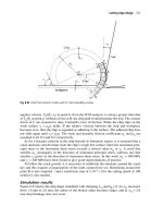
on the travels of the reporting vehicles—Figure 11.1 shows traces of five vehicles
reporting over a three-month period in the region of Regensburg, Germany.
260 Extending the Information Horizon Through Floating Car Data Systems
Table 11.2 Taxi-FCD System Coverage
City Number of taxis
Share of total
taxi fleet locally
Berlin 300 5%
Nuremburg 500 95%
Vienna 600 12%
Munich 220 6%
Stuttgart 700 95%
Regensburg
y (km)
x
(
km
)
4
4
2
2
0
0
−2
−2
−4
−4
Figure 11.1 FCD from taxis in Regensburg, Germany. (Courtesy of Ralf-Peter Schäfer, German
Aerospace Center, Institute of Transport Research.)
11.5.2 Research and Development Toward Next Generation FCD Services
The following projects provide a sampling of research activity funded by the public
sector and the automotive industry. They are presented in a rough chronological
order.
Road Traffic Advisor The Road Traffic Advisor project in the United Kingdom was
an early foray into vehicle-roadside communications for evaluation purposes.
Sponsored by the U.K. Highways Agency, 350 km of the motorway M4 from the
London airports to Swansea was instrumented with eighty 5.8-GHz beacons. The
goal was to develop the necessary in-vehicle electronics and an open architecture to
support a variety of applications. Among the applications investigated, FCD was
shown to be technically viable.
Sweden OPTIS Floating Car Data Pilot [1, 9] OPTIS was a project with the purpose
of developing cost-effective methods of collecting traffic data in order to provide
high-quality traveler information. OPTIS is part of the so-called Green Car ven-
ture being jointly conducted by the Swedish government and car manufacturers,
concerning the development of vehicles with improved environmental qualities
(including reductions in emissions resulting from improved traffic information and
reduced travel times). Major partners in OPTIS were SAAB Automobiles, Scania
Commercial Vehicles, Volvo Cars, Volvo Truck Corporation, and the Swedish
National Road Administration.
At a high level, the OPTIS goal was to show the feasibility of obtaining a quality
picture of the traffic status in a metropolis with wide geographical coverage, given a
reasonable number of FCD vehicles. The project also sought to establish that FCD is
a cost-effective alternative to stationary sensors, that FCD provides a cost-efficient
means of collecting data in more situations and locations than with other methods,
and that FCD can be implemented in such as way that it is commercially attractive
to telematics service providers.
The specific objectives of OPTIS were to build a server solution for FCD, verify
it through simulations, perform a realistic field trial to verify the simulations, and
establish an action program for deployment.
Field trials with 250 vehicles took place in Gothenburg during a six-month
period in 2002. The data concept was based on travel time. The cars in the study
were equipped with Volvo Oncall units modified with OPTIS algorithms. Position
data was transmitted to the OPTIS center where the data was processed into travel
times. Map matching was performed at the center, so that the cars did not need an
onboard digital map. Travel times were calculated at the road link level for each
probe by determining a position in the road network and identifying when a vehicle
passes the beginning and end of a link. The difference in the two times constituted
the measured travel time for the link.
OPTIS evaluations indicated that high-quality travel information could indeed
be produced with this system approach. The data allowed drivers to choose alterna
-
tive routes at major incidents, saving as much as 25 minutes on their trip. This was
in turn related to emissions reductions if such a system were deployed widely. Over
-
all, the FCD data was shown to offer a better overall picture of the traffic situation
as compared to road-based sensors. Further, the installation cost of the FCD solu
-
tion was estimated to be half that of a fixed detector system.
11.5 European FCD Activity 261