BIOMES OF THE EARTH - OCEANS Phần 2 ppt
Bạn đang xem bản rút gọn của tài liệu. Xem và tải ngay bản đầy đủ của tài liệu tại đây (2.32 MB, 28 trang )
GEOGRAPHY OF THE OCEANS 9
heated by volcanic rock until it seeps or bursts out through
clefts on the rift valley floor, called hydrothermal or hotwater
vents (from the Greek therme for “heat”). The exiting water is
rich in minerals and can reach temperatures of 716°F
(380°C). Since the late 1970s, when deep-sea hydrothermal
vents were seen for the first time, scientists have been fasci-
nated by the startling communities of microbes and animals
that live alongside them (see “Hot vents and cold seeps,”
pages 157–158).
Seas and gulfs
People often use the words sea and ocean to mean the same
thing. We can talk about going for a swim in the sea or ocean,
or living in sea-front or an ocean-front property. T
echnically
,
however, a sea is a geographic region of an ocean. For exam-
ple, the Sargasso Sea lies a few hundred miles off the Florida
coast in the North Atlantic Ocean. The Sargasso is sur-
rounded by a strong system of currents, which marks its
boundary with the rest of the ocean. It also contains a unique
community of plants and animals—floating seaweed and
small, well-camouflaged fish and other small creatures that
live among the weeds. The Sargasso Sea is a distinct part of
the North Atlantic.
In fact, most seas, such as the Mediterranean Sea and
Caribbean Sea of the North Atlantic, are partly or mostly
surrounded by land. They are called marginal seas because
they lie at the edges (margins) of the ocean. Gulfs and bays
are alternative names for areas of seawater partly enclosed
by land, as in the case of the Gulf of Mexico or the Bay of
Bengal.
Parts of an ocean, such as the Sargasso Sea, have character-
istic animal and plant communities because their distinctive
environmental conditions allow some organisms to survive
there and not others. The community of organisms living in
an ocean region also depends upon when, and from where,
animals and plants have colonized that area. If they entered
the region millions of years ago and they have become more
or less cut off from animals and plants in other regions, they
may have evolved considerably in adapting to the local
conditions. Over time, they may evolve to the point at which
they have become new species. They are now reproductively
isolated from (they cannot breed with) the forms from which
they evolved and which may still exist elsewhere. This hap-
pens not only within an ocean but also between oceans. So, for
example, the species of salmon found in the Atlantic Ocean
are different from those found in the Pacific. Because an
ocean’
s histor
y and environmental conditions exert such an
influence on the assemblage of organisms that inhabit it, it is
appropriate to consider the different oceans in more detail
before going any further.
The Pacific Ocean
The Pacific Ocean is the world’s largest expanse of sea, cover-
ing nearly one-third of Earth’s surface—more than 16 times
the area of the 50 U.S. states. The Pacific Ocean stretches
from the Arctic Ocean boundary near the North Pole to the
Southern Ocean at the opposite pole. At its widest point,
from the Americas in the east to Asia and Australia in the
west, the Pacific is about 11,000 miles (17,700 km) across.
Most geographers divide the Pacific’s expanse into two: the
North Pacific above the equator and the South Pacific below.
The Pacific Ocean is deep. It contains the Mariana Trench,
the deepest place on Earth’s surface. Altogether, the ocean
holds nearly half of the world’s seawater. If all the world’s
landmasses were scraped off at sea level and dumped into the
Pacific Ocean basin, they would not fill it.
The Pacific gained its name from the Portuguese round-
the-world explorer Ferdinand Magellan (ca. 1480–1521). In
1520 Magellan called the ocean Mar Pacifico, Portuguese for
“The Calm Sea,” because of his expedition’
s experience of its
quiet waters. In fact, typhoons or tropical cyclones (the
names for hurricanes in different parts of the Pacific) fre-
quently batter communities around the Pacific. In addition,
earthquakes, volcanoes, and landslides regularly shake the
margins of the Pacific Ocean and trigger giant waves called
tsunamis (Japanese for “harbor waves”).
Few large rivers flow into the Pacific, so its coastal waters
are largely undiluted by freshwater
. The Pacific receives cold
10 OCEANS
GEOGRAPHY OF THE OCEANS 11
seawater from the Southern Ocean, but its connection with
the Arctic Ocean is narrow, and little seawater flows between
the two. The surface waters of the North Pacific are domi-
nated by a circulating system of currents called a gyre. The
North Pacific gyre flows clockwise, under the influence of the
Earth’s rotation (a phenomenon called the Coriolis effect; see
“The effect of Earth’s rotation,” pages 71–73). A similar mas-
sive gyre in the South Pacific turns counterclockwise, influ-
enced by the same effect.
The Pacific Ocean basin lies on several of Earth’s massive
plates (giant slabs of Earth’s crust and underlying rock).
Along the edges of the Pacific basin a series of trenches take
ancient oceanic crust down beneath the surface of the Earth.
The descending crust melts and feeds a system of volcanoes
that erupt lava onto Earth’s surface. Some volcanoes rise
above the sea surface to form volcanic island chains. Others
emerge on continental landmasses. Together, these volcanic
systems almost encircle the Pacific. They form the aptly
named “Ring of Fire.”
While old seafloor is being destroyed, new seafloor is being
created elsewhere. In the eastern Pacific a mid-ocean ridge
system called the East Pacific Rise is laying down new
seafloor at the rate of six inches (15 cm) width each year.
Overall, however, Pacific seafloor is being destroyed at a
faster rate than it is being replaced. As a result, the Pacific
Ocean basin is gradually shrinking.
Thousands of volcanoes—most of them long extinct—rise
up from the Pacific seafloor. Many remain submerged as
seamounts. Others rise above the sea surface as volcanic
islands. Where islands form in warm waters, coral reefs
(rocky formations formed from the limestone skeletons of
tiny animals) often grow on their flanks. In many cases these
coral-rimmed islands gradually sink over millions of years.
Pacific Ocean data
Area 58,957,258 square miles (152,617,160 km
2
)
Average depth 13,874 feet (4,229 m)
Maximum depth 35,840 feet (10,924 m) Mariana Trench
Volume 154,960,672 cubic miles (643,375,552 km
3
)
When they disappear beneath the sea surface, the island’s
location is often marked by a ring of coral, a coral atoll (see
the sidebar “Coral atolls,” page 153). Thousands of these
amazing structures lie scattered across the tropical and sub-
tropical Pacific Ocean.
The Atlantic Ocean
The Atlantic Ocean gains its name from the mythical Greek
Titan Atlas who held up the heavens. His name was given to
the Atlas Mountains of North Africa, and the region of sea
next to this mountain range became the Atlantic.
The Atlantic Ocean, at about nine times the size of the 50
U.S. states, is the second largest of the five oceans. It sepa-
rates Europe and Africa from the Americas. For convenience,
oceanographers divide it into two: the North Atlantic and the
South Atlantic, separated by the equator.
The Mid-Atlantic Ridge runs snakelike, from north to
south, down the center of the Atlantic. In places on or close
to the ridge, volcanoes have risen up to create islands such as
those of the Azores and, recently, Surtsey, near Iceland. Else-
where, at the rift in the middle of the ridge, lava rises up and
forms new seafloor. The plates on either side of the ridge are
moving apart at the rate of at least one inch (2.5 cm) a year,
carrying the continents with them. In consequence, the
Atlantic Ocean is getting wider. It is at least 40 feet (12 m)
wider than when Christopher Columbus sailed from Europe
to the Bahamas in 1492. The continents on either side of the
Atlantic have roughly interlocking shapes, like the pieces of a
jigsaw puzzle, and this neat fit provided the German geolo-
gist Alfred Wegener (1880–1930) with evidence for his theory
of continental drift in the early 20th century (see “Continen-
tal drift,” pages 32–34).
In the North Atlantic the major system of ocean currents—
the North Atlantic gyre—flows in a clockwise direction. In
the west the gyre picks up warm water emerging from the
Gulf of Mexico and carries it eastward across the Atlantic as
the Gulf Stream. Much of this water then diverts northeast,
toward the Arctic Ocean, as the North Atlantic Drift. The
warming effect of the Gulf Stream and North Atlantic Drift
12 OCEANS
GEOGRAPHY OF THE OCEANS 13
keeps northwest Europe unusually mild. Winter tempera-
tures in London, England, are typically about 18°F (10°C)
warmer than those on the mainland of Newfoundland,
Canada, which lies at the same latitude but on the opposite
side of the ocean and is cooled by a current flowing south
from Baffin Bay.
In late summer and early fall the circulating warm water of
the North Atlantic gyre feeds the surface waters of the tropi-
cal North Atlantic. Warm water heats the overlying air, and
some of the water evaporates, releasing more heat energy
into the air and creating warm updrafts of moist air. Some
updrafts are sufficiently powerful to spawn hurricanes—vio-
lent tropical storms with wind speeds in excess of 74 mph
(119 km/h), such as Hurricane Katrina, which struck the
coasts of U.S. Gulf states in August 2005. That hurricane
killed more than a thousand residents.
In the South Atlantic the counterclockwise gyre supplies
tropical waters with seawater chilled by the Southern Ocean.
As a result, the South Atlantic’s tropical waters are too cool
for hurricanes to form.
The Indian Ocean
The Indian Ocean, named after the subcontinent of India, is
the third largest of the five oceans. Unlike the Pacific and
Atlantic Oceans, the Indian Ocean lies mostly in the South-
ern Hemisphere (south of the equator), and its tropical
waters are bounded to the north by landmasses. This arrange-
ment sets up unusual seasonal changes that affect the north-
ern Indian Ocean’s currents and the climates of adjacent
landmasses.
The present shape of the Indian Ocean basin can be traced
to geological events of at least 130 million years ago. At that
Atlantic Ocean data
Area 31,563,463 square miles (81,527,400 km
2
)
Average depth 12,391 feet (3,777 m)
Maximum depth 28,232 feet (8,605 m) Puerto Rico Trench
Volume 73,902,416 cubic miles (307,902,776 km
3
)
time, a southern supercontinent called Gondwana began to
break up, creating most of the landmasses that now border
the Indian Ocean. One of Gondwana’s fragments split in
two, with one piece drifting northward to become what we
recognize today as Africa. The second piece remained in the
far south. About 50 million years ago the southerly piece
broke in two, creating Antarctica and Australia. Meanwhile, a
large chunk of the African landmass tore free and drifted
northward over millions of years, eventually colliding with
Asia to form the Indian subcontinent. Remnants of this
northward movement are visible as the Seychelles—islands
in the northwest Indian Ocean that are fragments the mov-
ing India left scattered behind.
Today the Indian Ocean basin is dominated by a mid-
ocean ridge system that extends from north to south in the
shape of an upside-down Y. Elsewhere, hot spots (places
where deep-lying molten rock has burned through Earth’
s
crust) have created volcanic ridges, seamounts, and occa-
sional volcanic islands. An Indian Ocean hot spot may be
responsible for creating the longest straight-line feature on
Earth, the Ninety East Ridge, which runs north to south close
to longitude 90
°E.
In the northeast Indian Ocean two massive river systems,
the Ganges and Brahmaputra, empty sediment-laden fresh-
water into the Bay of Bengal. The rivers’ load of particles dis-
charged over many thousands of years has produced a
sediment fan that extends across the seafloor more than 900
miles (1,450 km) from land.
As a rule, landmasses warm faster and cool more rapidly
than the adjacent sea. During the Northern Hemisphere sum-
mer the Asian mainland warms more quickly than the adja-
cent northern Indian Ocean. Air expands and rises as it
14 OCEANS
Indian Ocean data
Area 26,064,036 square miles (67,469,536 km
2
)
Average depth 12,720 feet (3,877 m)
Maximum depth 23,376 feet (7,125 m) Java (Sunda) Trench
Volume 62,780,380 cubic miles (261,590,400 km
3
)
GEOGRAPHY OF THE OCEANS 15
warms, and rising warm air over India in summer draws in
moisture-laden monsoon winds from the Indian Ocean lying
to the southwest. These summer monsoon winds, and their
clouds, unload torrential rain onto India and some of its
neighbors. The summer monsoons, blowing from the south-
west, drive a northerly current along the African coast, feed-
ing a clockwise gyre in the northern Indian Ocean in
summer.
In winter the Indian subcontinent cools faster than the
nearby ocean. Rising warm air now lies over the northwest-
ern Indian Ocean, and the monsoon winds reverse direction,
blowing from the northeast. This prompts a reversal in the
direction of the northern Indian Ocean gyre, which now
flows counterclockwise. This annual reversal of a major
ocean gyre is unique to the northern Indian Ocean. The gyre
in the southern Indian Ocean, like that in the South Pacific
and South Atlantic, flows counterclockwise all year round.
Tropical cyclones (the Indian Ocean version of hurricanes)
occasionally batter the Bay of Bengal. Their storm surges
cause extensive flooding, sometimes with great loss of life. In
1970 the disruption produced by a cyclone killed at least
300,000 people in Bangladesh.
The Southern Ocean
The Southern Ocean, sometimes called the Antarctic Ocean,
is the fourth-largest ocean. It surrounds the continent of
Antarctica, which straddles the South Pole. Antarctica is the
coldest place on Earth, yielding a record low temperature of
–89.2°C (–128.6°F) in 1983. The Southern Ocean is partially
frozen all year round.
In 2000 the International Hydrographic Organization
(IHO), the organization that decides geographical names and
boundaries in the ocean, designated the boundary of the
Southern Ocean at latitude 60°S. This arrangement served
practical and political purposes. The 60°S boundary coincides
with the Antarctic Treaty boundary based on an interna-
tional agreement that governs how Antarctica and its ocean
waters should be used and protected. The natural boundary
of the Southern Ocean is a feature called the Antarctic
Convergence. This lies mostly north of 60°S, but in some
places reaches as far north as latitude 48°S. The Antarctic
Convergence is where warm and cool currents mix. To the
north of the Convergence surface waters are noticeably
warmer than to the south.
Within the Southern Ocean two major systems of surface
currents flow in opposite directions. The East Wind Drift
hugs the Antarctic coast and flows from east to west. Farther
north, and flowing west to east, lies the Antarctic Circumpo-
lar Current. This ocean current is the world’s largest in terms
of volume. It carries about 100 times the water of all rivers
combined. It is also the only ocean current to flow right
around the world, uninterrupted by landmasses.
The Southern Ocean’s floating ice forms in two ways: Some
ice slides off Antarctica and breaks off (calves) as floating
chunks (icebergs), and some of the seawater freezes to form
sea ice.
Antarctica is almost entirely covered in a sheet of ice that
averages about 5,750 feet (1,600 m) thick. This ice sheet—
and the ice that extends from it over the surface of the South-
ern Ocean as ledges called ice shelves—contains an
astonishing 90 percent of the permanent ice on Earth. This
huge weight of ice has made Antarctica sink low in the
ocean, so that its continental shelves reach more than 1,600
feet (490 m) deep—about three times the average depth of
continental shelves in other oceans. To the north, beyond
the Southern Ocean’s basins, lie parts of the mid-ocean ridge
system that continue through the Pacific, Atlantic, and
Indian Oceans.
In the Antarctic winter, with coldest temperatures from
June to September, seawater freezes at the surface of the
Southern Ocean. This sea ice reaches more than 33 feet (10
m) thick and in places reaches more than 1,000 miles (1,600
km) from the Antarctic coast. In winter the Southern Ocean’s
floating ice covers an area five times its summer extent.
Each year several thousand floating chunks of ice calve
from Antarctica’s ice shelves as icebergs. Many of the icebergs
are very wide and flat-topped. Some cover vast areas. One
Antarctic iceberg was measured covering an area equivalent
to the country of Belgium. The icebergs drift slowly north-
16 OCEANS
GEOGRAPHY OF THE OCEANS 17
ward for months on end, some reaching cool temperate
waters before they melt away completely.
The Arctic Ocean
The Arctic Ocean is the smallest and shallowest of the five
oceans. Lying north of latitude 66.5°N (the Arctic Circle), with
the North Pole at its center, the Arctic Ocean is partially
frozen all year round, rather like the Southern Ocean. But
whereas the Southern Ocean is an ocean surrounding a conti-
nent, the Arctic Ocean is an ocean almost entirely surrounded
by land. It is bordered to the south by North America, Green-
land, and Europe and Asia (Eurasia). The ocean gains its name
from the Greek arktos for “bear,” referring to the northern
constellation of stars called the Great Bear (Ursa Major in
Latin), otherwise known as the Big Dipper.
The Arctic Ocean is also unusual in having the largest pro-
portion of continental shelf of any ocean. Nearly half of the
Ar
ctic Ocean seabed is less than 660 feet (200 m) deep. In
fact, the Ar
ctic Ocean was only confirmed as a true ocean
with a deep basin, rather than a shallow sea, in the 1890s. At
that time the expedition of Norwegian explorer Fridtjof
Nansen in the vessel Fram recorded soundings (depth read-
ings) of more than 9,840 feet (3,000 m).
Floating sea ice (formed from frozen seawater) covers
about half of the Ar
ctic Ocean in summer and nearly all of it
in winter. Seawater mixing between the Ar
ctic and other
oceans occurs mainly in the Atlantic, in the gap between
Norway and Greenland. Here warm water from the North
Atlantic Drift sweeps northward along the Norwegian coast.
This Norwegian Current keeps much of Norway’s coastline,
and some of the Arctic Ocean, free of ice even in the depths
of winter. A southward-flowing cool current leaves the Arctic
Southern Ocean data
Area 8,102,165 square miles (20,973,318 km
2
)
Average depth 11,188 feet (3,410 m)
Maximum depth 23,737 feet (7,235 m) South Sandwich Trench
Volume 17,165,720 cubic miles (71,518,408 km
3
)
Ocean and flows past Greenland as the Greenland Current. It
keeps Greenland’s eastern coast locked in ice for most of the
year. In the main expanse of the Arctic Ocean the overall
movement of currents—and the ice floating on them—is in a
clockwise direction.
Each year western Greenland’s and northeast Canada’s gla-
ciers (slowly moving “rivers” of ice on land) shed more than
10,000 icebergs. The icebergs float south on the Labrador
Current and some drift into the North Atlantic as far as the
waters off Newfoundland before melting away. One of these
icebergs collided with the RMS Titanic in 1912, sinking the
ship with the loss of more than 1,500 lives. This tragic event
prompted the establishment of the International Ice Patrol,
which monitors the movement of North Atlantic icebergs
and issues warnings to ships.
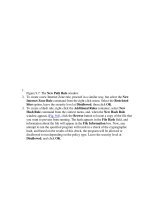
Marginal seas of the North Atlantic
To what extent do environmental factors, such as tempera-
ture and salinity, vary within an ocean? And how does this
variation affect marine life? Conditions at the top of the
ocean are very different from those at the bottom (see
“Depth zones,” pages 143–146). But even in the waters near
the surface, environmental conditions vary from one loca-
tion to another. These changes are particularly marked at the
edges of the ocean, where the effect of land is greatest. About
a dozen seas border the North Atlantic. Considering just
three of these from different climatic zones illustrates how
much their conditions can differ.
The Caribbean Sea lies between South and Central Amer-
ica, with Cuba to the north and the Caribbean Island groups
of the Greater and Lesser Antilles to the east. Although the
Caribbean Sea is now part of the Atlantic Ocean, more than 3
18 OCEANS
Arctic Ocean data
Area 3,351,811 square miles (8,676,520 km
2
)
Average depth 6,349 feet (1,935 m)
Maximum depth 18,400 feet (5,680 m) Molloy Deep
Volume 4,028,950 cubic miles (16,790,582 km
3
)
GEOGRAPHY OF THE OCEANS 19
million years ago the Caribbean Sea was also joined to the
Pacific. The narrow strip of land called the Isthmus of
Panama now closes off this connection.
The bottom of the Caribbean Sea is probably part of the
Pacific Ocean plate that has split away, and the Caribbean is
more like a deep ocean basin than a shallow sea. Surface
water flows into the Caribbean from the North Atlantic to
the east, warms as it crosses the Caribbean, and then feeds
the Gulf of Mexico to the north with warm water. Further
warming in the Gulf produces Gulf Stream water that flows
out into the North Atlantic.
Among the spectacular features of the Caribbean Sea are its
widespread coral reefs. Scientists who study the fossil record,
called paleontologists, have revealed that more than 60 per-
cent of Caribbean coral species have arisen since the sea
became separated from the Pacific. At the same time some
coral species that were once widespread in the Caribbean
became extinct. For example, several groups of reef-building
corals are found on the Pacific side of the Isthmus of Panama
but are now absent in the Caribbean.
The Mediterranean Sea lies between southern Europe,
North Africa, and northwest Asia. It is a remnant of the
Tethys Sea that 180 million years ago separated the world’s
two ancient supercontinents—Laurasia to the north and
Gondwana to the south (see “The changing shape of the
oceans,” pages 39–42). Today the Mediterranean is con-
nected to the North Atlantic through the narrow Strait of
Gibraltar to the west and to the Black Sea through the Sea
of Marmara to the east.
In 1869 excavators under the direction of the French
diplomat Ferdinand de Lesseps (1805–94) completed the Suez
Canal, which links the Mediterranean Sea to the Red Sea.
Since that time several hundred Red Sea species have passed
through the Suez Canal and established themselves in the
Mediterranean Sea.
The surface flow of water in the Mediterranean is from the
Atlantic Ocean through the Strait of Gibraltar and toward the
Black Sea. At depths of 650–2,300 feet (200–700 m) there is a
return flow of saltier than normal, nutrient-rich water. This
loss of nutrients from the Mediterranean Sea to the Atlantic
Ocean helps account for the fairly low production of life in
the Mediterranean compared with other marginal seas.
Mediterranean waters do not contain coral reefs because they
are too cool for reef-building coral polyps (see “The living
reef,” pages 151–154).
About 6 million years ago, during a long cold spell in
Earth’s history when sea levels fell, the Mediterranean Sea
became cut off from the North Atlantic. The Mediterranean’s
water evaporated without being replaced so that the sea
eventually dried up completely. Thick deposits of salt were
left on what was once the floor of the Mediterranean Sea. All
marine life in the Mediterranean Sea died out. Then, by
about 5 million years ago, the global climate warmed and sea
levels rose. North Atlantic water poured back into the
Mediterranean basin near Gibraltar in what some geologists
describe as “the world’s biggest waterfall.” All the Mediter-
ranean Sea’s animals and plants have evolved from ancestors
that arrived within the last 5 million years.
Today the Mediterranean still loses water by evaporation at
a great rate, and replacement is slow, so the salinity (salti-
ness) of Mediterranean water is generally slightly above that
in the North Atlantic. The salinity of most ocean waters is
about 35 parts per thousand (meaning 35 grams of salts per
1,000 grams of seawater). The Mediterranean averages 38
parts per thousand. Today the community of animals and
plants in the Mediterranean is similar to that in the adjacent
warm temperate waters of the North Atlantic, except for
recent additions, such as the 140 or so species of zooplankton
(animal plankton) that have arrived from the Red Sea.
The Baltic Sea is the shallow inland sea of northern
Europe. Separated from the main body of the Atlantic Ocean
by the North Sea, it is fed by several major rivers, notably the
Vistula, Oder, and Neva. Because the Baltic’s connection to
the North Sea is narrow and evaporation is slow in the cool
climate, the rivers’ high input of freshwater strongly dilutes
Baltic seawater. As a result, at the sea’s northern end Baltic
seawater is almost freshwater, with salinities less than five
parts per thousand. At the Baltic’s southern end, where it is
connected to the North Sea, salinities reach 30 parts per
thousand (less than the Atlantic’s average of 35 parts per
20 OCEANS
GEOGRAPHY OF THE OCEANS 21
thousand). In addition, the Baltic Sea, unlike the North Sea,
is separated from the warming effect of the North Atlantic
Drift, so large areas of the Baltic Sea freeze in winter. These
environmental conditions mean that only a restricted range
of marine species survive in the Baltic Sea, such as those that
can tolerate changing salinities. The Baltic—being so shallow
and poorly flushed with seawater—does not disperse pollu-
tants quickly, so contaminated water can take a long time to
be flushed out of the Baltic. For such reasons, a restricted
The North Atlantic
Ocean and its major
seas, gulfs, and bays
Gulf of Guinea
Mediterranean Sea
Cape Verde Basin
Cape Verde Islands
Canary Islands
Barents Sea
Norwegian Sea
Greenland Sea
Labrador Sea
Baffin Bay
Hudson Bay
North Sea
Azores
Guiana Basin
Caribbean Sea
North American
Basin
North Eastern
Atlantic Basin
ARCTIC OCEAN
Gulf of
Mexico
M
i
d
-
A
t
l
a
n
t
i
c
R
i
d
g
e
EUROPE
AFRICA
SOUTH
AMERICA
NORTH
AMERICA
GREENLAND
Baltic Sea
ATLANTIC OCEAN
range of organisms survives in the Baltic, but those that
can—including clams, bristle worms, and amphipod crus-
taceans—have abundant food supplies and can flourish.
Different histories and different environmental conditions
mean that these three marginal seas of the North Atlantic
contain very different communities of organisms. Similar
comparisons could be made for seas in other oceans, with
similar striking contrasts.
Shores
Shores are the places where the land meets the sea: places
where people can push their toes into coral sand, clamber
over rocks to discover tide pools, or sink knee-deep in foul-
smelling mud. They are magical places of recreation that
bombard the senses: the rhythmic crashing of waves, the
smell and taste of salty air, the sun and sea breeze against the
skin.
Oceanographers define a shore quite precisely. A shore’s
lower boundary is the seabed that is exposed to the air by the
very lowest tides. Its upper boundary is the edge of the land
that is splashed by the biggest storm waves. Between these
two lies the shore.
Inland of the shore is a coastal strip that is markedly
affected by the nearby presence of the sea. Salty spray, for
example, is blown inland onto the coastal strip and affects
the kinds of plant life that can grow there. The winding
boundary line between the shore and the coastal strip is
called the coastline.
New shores are created by geological upheavals, when land
sinks (subsides) or rises (uplifts) relative to the sea or land.
Fresh land or seabed is brought to the edge of the sea. Once
this happens, the shore becomes shaped gradually by the
action of winds, waves, tides, and currents. Whether a shore
is steep and rocky or gentle and sandy depends on the partic-
ular combination of physical, chemical, geological, and bio-
logical conditions. A starting point is the height and slope of
the land relative to the sea. One factor that influences this is
the distance of the shore from a plate boundary. Most of the
U.S. Pacific coast lies close to a plate boundary, and in many
22 OCEANS
GEOGRAPHY OF THE OCEANS 23
places the coast is being uplifted; the result is coastal cliffs
that tower above rocky shores, interspersed by occasional
beaches. In stark contrast, the U.S. Atlantic coast is a long
way from a plate boundary. The land here is slowly subsid-
ing, bringing inland rock and soil into contact with the sea.
Here, in many places, the beaches are wide, gently sloping,
and sandy or muddy.
The seashore is a harsh environment. It is alternately
exposed to the air when the tide falls, and then flooded with
seawater when the tide rises. Animals and plants that stay on
the shore contend with extremes. When the tide is low,
seashore organisms may have to deal with baking sunlight
on the one hand, which dries them out, or torrential rain on
the other, which covers them in freshwater, not the salty sea-
water they are used to. Once the tide rises, they may be bat-
tered by waves or at the mercy of a host of marine grazers and
predators. Those that can survive the demanding conditions
reap rich rewards. Seaweeds can flourish in the shallow, sun-
bathed, nutrient-rich water. And for animals, the rising tide
brings in abundant fresh supplies of food.
Estuaries and deltas
Estuaries are the coastal locations where rivers discharge into
the sea—where freshwater mixes with seawater. Some estuar-
ies, especially those with stark mudflats etched by creeks,
seem to be the most forbidding places on a coast. But they
are much more important—to people and to wildlife—than
appearances suggest.
Geologists (scientists who study Earth’s structure and the
processes that affect it) generally recognize four kinds of estu-
aries, based on how they form, which, in turn, shapes their
appearance. Chesapeake Bay, lying between Maryland and
Virginia, is an example of a coastal plain estuary, so called
because it is flat land around the mouth of a river that has
been drowned by the sea. San Francisco Bay, on the other
hand, with its fairly steep-sided borders, is a tectonic bay,
formed when land subsided as a result of ground movement
along faults (major fractures in the rock) such as the nearby
San Andreas Fault.
Pamlico Sound, North Carolina, is a bar-built estuary. Such
estuaries are shallow and separated from the open ocean by
deposited sandbars or barrier islands (see “Sheltered shores,”
pages 48–51). Finally, fjords are deep U-shaped valleys that
were originally gouged out by glaciers and have become
flooded with seawater. They are common in coastal moun-
tainous regions at high latitudes. Prime examples are visible
on the west coasts of Alaska, Canada, and Norway.
A delta (named after the triangular Greek letter ∆) is a tri-
angular or fan-shaped plain of sediment that sometimes
forms at the mouth of a river
. The largest, such as the Missis-
sippi Delta and Egypt’
s Nile Delta, are more than 60 miles
(about 100 km) across. They form where coastal currents fail
to spread river-dumped mud and sand along the coast.
Instead the sediment stays at the river mouth, eventually
clogging it. The river then becomes restricted to several
branched channels, called distributaries, that cross the low-
lying delta.
Most estuaries contain plenty of mud—particles of clay
and other fine material—brought down by the river. The
mud settles on the estuary floor and sides, where it forms
mudflats that become exposed at low tide. The close-packed
particles in mud do not allow much oxygen to penetrate, so
the mud is usually black and foul-smelling beneath the sur-
face. Few animals are adapted to live in these oxygen-poor
conditions, and among those that are able to, most live in
the top inch or so or have burrows that bring in fresh sup-
plies of water and oxygen.
The drastic changes in salinity (saltiness) pose another
problem for creatures living in estuaries. At low tide, and
especially after heavy rainfall, the river’s water strongly
dilutes the seawater of the estuary. When the tide is high,
and river flow is reduced, the river’s influence is minimal,
and the estuary water can be nearly full-strength seawater.
Only a fairly small range of marine organisms can tolerate
such dramatic changes in salinity. But for those that can, the
benefits are great. The river brings with it plentiful nutrients
for the microbes (microscopic organisms) and simple plants
that form the base of food chains and on which burrowing
animals can feed (see “Food chains and food webs,” pages
24 OCEANS
GEOGRAPHY OF THE OCEANS 25
135–138). A single square foot of mud (about 0.1 m
2
) can
contain 300 burrowing clams. These and other mud dwellers
provide food for thousands of birds that visit estuaries. The
birds, in turn, provide a valuable environmental service.
When they release their droppings on land, they recycle use-
ful nutrients that were earlier washed off the land into rivers.
Coastal wetlands
Where coastal land gently slopes, as in many places on the
U.S. Atlantic and Gulf coasts, a small rise or fall in sea level—
as with rising and falling tides—means that large areas of
coastal land becomes alternately flooded and then exposed
to the air. The land here may become waterlogged with sea-
water, and only a few types of land plants can survive such
salty conditions. In temperate regions these coastal wetlands
are called salt marshes. In tropical and subtropical climates
they form mangrove swamps (see “Missing mangroves,”
pages 212–213).
Many people are familiar with the strange, barren land-
scape of a North American or European salt marsh, where
clumps of tough marsh plants grow between muddy creeks.
In summer the air is filled with the song of skylarks. In win-
ter flocks of gray geese arrive from their Arctic breeding
grounds. At the salt marsh’s seaward edge salt-tolerant cord
grasses are almost the only land plants that survive. Toward
the landward edge grow a limited range of rushes and grasses,
as well as salt-tolerant succulents (fleshy-leaved, moisture-
conserving plants) such as glasswort.
Salt marshes, like the muddy estuaries they often border,
are demanding places for organisms to live, but they harbor
hidden treasures. The salinity in the salt marsh varies from
saltier than seawater to freshwater. The tough plants that sur-
vive here are difficult to digest, so local animals’ main food
supplies take the form of decayed plant material that micro-
scopic organisms, particularly bacteria and fungi, have par-
tially decomposed. Animals such as lugworms and clams feed
on the microbes and partly decayed plant material found in
and on the mud. These creatures are, in turn, food for larger
animals such as fish and crabs. Wading birds such as plovers,
sandpipers, and oystercatchers, and migratory birds such as
ducks and geese, arrive at salt marshes in large flocks. The
birds consume mud-living animals and fish and shellfish that
live in the creeks. In some cases the birds breed here, too. Salt
marshes provide safe havens because large predators from
both land and sea find the maze of mud and creeks difficult
to walk upon or swim through.
Salt marshes and mangrove swamps play a beneficial role,
both for people and for the environment. First, the wetland’s
tangle of plant roots binds the mud and helps protect the
coastal land from erosion by waves and currents. Second, the
wetland mud behaves like a chemical processing factory. The
mud particles attract and hold poisonous heavy metals such
as lead and mercury. The roots of marsh plants absorb
nitrates, such as those originating from fertilizers spread on
agricultural land. The wetlands thus “clean” the water that
passes through them, preventing many harmful substances
from washing off the land and into the sea. Finally, coastal
wetlands are important nurseries (places where young grow)
for valuable fish and shellfish. The salt marsh creeks of the
southeast United States serve as nurseries for the young of
half the locally caught fish species. Fishers also harvest clams,
oysters, and scallops from these creeks. In warmer climates
the waters around the tangle of mangrove roots harbor the
larvae of fish and shrimp that will disperse over a wide area
when they grow into adults. When people drain or dig up
salt marshes and mangrove swamps to build coastal develop-
ments, the wetlands’ valuable environmental services are
lost.
Islands
An island is a landmass, smaller than a continent, sur-
rounded by water. The world’s largest island, Greenland, is
several times smaller than the world’s smallest continent,
Australia. The Pacific Ocean alone has at least 25,000 islands,
many of which are barely a few tens of yards across. Most
geographers recognize three types of marine island based on
their origins: inshore islands, offshore islands, and oceanic
islands.
26 OCEANS
GEOGRAPHY OF THE OCEANS 27
Inshore islands lie on continental shelves. They were once
joined to the continental mainland. Since that time sea levels
have risen or the continental landmass has sunk (subsided)
so that the land connection between the two has become
submerged. The British Isles are islands of this type. Only
18,000 years ago, at the peak of the last ice age, they were
connected to the European mainland. Since then, the gla-
ciers and ice sheets that covered much of northern Europe
have melted away. Seawater levels have risen by about 300
feet (90 m), and the land connection is now engulfed, with
most lying at least 165 feet (50 m) beneath the North Sea and
English Channel.
Offshore islands lie fairly close to continental landmasses
but not on continental shelves. Some offshore islands were
once connected to the nearby mainland, but they have been
separated for millions of years. Others have never been part
of the mainland. However, their closeness to the mainland—
or their previous connection—means that they contain
many of the same species of animals and plants that are
found on the nearby continent. Many have colonized the
islands by drifting on ocean currents, or, in the case of some
animals, they have swum or flown across. Some offshore
islands become refuges for animals that have died out on the
mainland.
Madagascar, an offshore island cut off from Africa for
many millions of years, today contains 30 species of
prosimian (primitive members of the animal group that
includes apes and monkeys). Many of these prosimian
species, or closely related ones, have died out on mainland
Africa, where they have lost out in competition with more
recently evolved monkeys. On isolated Madagascar, however,
which monkeys have not yet reached, the prosimians have
survived.
Oceanic islands lie several hundred miles or more from the
nearest mainland. Volcanoes that punched their way to the
sea surface have created most of them.
Most oceanic islands are only a few tens of miles across, or
less. But they are much more important than their size sug-
gests. Because these islands are so remote, animals and plants
that arrive there and set up breeding populations may evolve
in isolation from their relatives elsewhere. Over many gener-
ations as the members of these populations adapt to life in
their island home, those characteristics that equip them for
survival are selected, and those individuals with these charac-
teristics tend to be the ones that survive to breed. Over many
generations the island animals and plants evolve to become
slightly different from the mainland relatives from which
they originated. As a result, some of the larger oceanic islands
contain an unusually high proportion of species found
nowhere else. For instance, biologists studying the animals
and plants of the Galápagos Islands, lying in the Pacific
Ocean about 600 miles (960 km) off Ecuador, have so far
described about 5,000 species. Of these, about one-third are
found nowhere else.
In the water, too, oceanic islands have great influence.
Their sides deflect deep water toward the surface. This deep
water is rich in nutrients that have come from the break-
down of waste matter and dead organisms. In the sunlit sur-
face waters this injection of nutrients helps microscopic
plantlike organisms called phytoplankton to grow. Animal
plankton (zooplankton) feed on the phytoplankton, and
they are consumed by fish, which in turn are eaten by larger
fish and marine mammals. In warm clear waters, coral reefs
grow on the flanks of islands, producing the most complex
animal and plant communities in the ocean (see “The living
reef,” pages 151–154).
Seamounts
There are between 30,000 and 50,000 seamounts across the
world. These extinct underwater volcanoes pepper the
abyssal plains of the deep ocean, rising at least 3,280 feet
(1,000 m) above the seafloor. They are magnets for marine
life.
In the vast ocean expanses seamounts are like oases. As
ocean currents sweep past a seamount, the seawater is swirled
into eddies and pushed toward the surface. Nutrient-rich
water rises near the surface, encouraging the growth of phy-
toplankton on which marine animals, directly or indirectly,
depend for food. Above the seamount a rich community of
28 OCEANS
GEOGRAPHY OF THE OCEANS 29
marine life develops. Large predators, such as dolphins and
sharks, will journey from one seamount to the next to har-
vest the schools of smaller fish that gather there.
These underwater mountains survive for millions of years.
The larvae of bottom-dwelling animals—sponges, soft corals,
sea anemones, crabs, sea squirts, and the like—settle there.
Separated from other clusters of seamounts by hundreds of
miles of flat, deep seabed, the creatures can evolve in isola-
tion. As a result, many seamounts come to harbor an unusu-
ally high proportion of local species—species that are absent
in other parts of the ocean. If the seamount rises to within a
few dozen feet of the sea surface in tropical waters, hard
corals—the kind that establish vibrant coral reef communi-
ties—will also grow there.
The importance of seamounts has only become apparent
in the last 30 years. Technology now exists for divers to use
underwater vehicles and sophisticated sonar devices to locate
and explore these structures with greater ease.
Earth’s structure
Various strands of evidence, such as the age of Moon rocks
and meteorites, lead scientists to believe that the solar system
(the Sun and its orbiting planets) formed about 4.6 billion
years ago. The parts of the solar system came together from
bits of space debris. These originated from the birth of matter
in a universe-creating explosion some 13 billion years ago,
which scientists call “the big bang.”
When the solar system’s larger planets, including Earth,
began to assemble around the Sun, they were red-hot. Part of
the reason for this is that when space debris collides at high
speed, it releases its energy of movement as heat. When Earth
began to assemble from this debris, it also contained many
radioactive chemicals (those that break down of their own
accord to release large amounts of energy). This generated
more heat. The young planet Earth therefore formed as a
fiery ball of melted substances. Within Earth the substances
arranged themselves according to their density (heaviness).
Under Earth’s gravitational pull, less dense (lighter) material
floated to the planet’s surface, while denser (heavier) sub-
stances sank to the center of the planet. By about 4 billion
years ago, Earth began to cool, and as it did so it formed an
outer solid layer—a crust.
Today, Earth consists of several layers: crust and rigid upper
mantle, two layers of mantle below these, and then an outer
and inner core at the center. Scientists know this from indi-
rect evidence. It is not yet possible to drill very far beneath
Earth’s surface. The deepest bore hole is about 7.5 miles (12
km) deep—reaching not even halfway through Earth’s outer
layer of rock on land, called the continental crust. However,
scientists can gather useful information even at this depth.
The temperature rise over this distance enables scientists to
GEOLOGY OF THE OCEANS
CHAPTER 2
30
GEOLOGY OF THE OCEANS 31
calculate Earth’s likely temperature 1,865 miles (3,000 km)
beneath the surface at the outer edge of the core. They work
out this temperature to be an astonishing 7,050°F (3,900°C).
Scientists gain information about the chemical makeup of
the deep crust and mantle from lava (molten rock) that
erupts from volcanoes. Earthquakes also yield clues about the
different layers. Earthquakes are shock waves in the ground
produced when masses of rock underground suddenly slip
past one another. The resulting shock waves travel in all
directions through the rock. Scientists can detect the shock
waves at the surface, using vibration-sensing instruments
such as seismometers. Earthquakes produce three main types
of shock waves, and how these waves are bent or bounced by
the rock at different levels tells scientists about the size and
consistency of Earth’s layers.
The ground beneath our feet—the crust—seems solid
enough, but deep below the surface, in the outer core, the
rock is molten. Closer to the crust, in the mantle layer, lies a
region called the asthenosphere (from asthenos, Greek for
“weak”) that is almost solid but acts like a liquid moving in
slow motion. The rock we stand on “floats” on this layer and
ver
y slowly moves across the surface of Earth, up to a few
inches a year
.
Much of the rock on Earth’s surface originally came from
hot, molten rock, or magma, from within the mantle or deep
crust. When this magma cooled, it became solid. Rock
formed in this way is called igneous rock, and there are two
common kinds: basalt and granite. Basalt is a fine-grained,
dark rock that is rich in silica (Si) and magnesium (Mg).
Basalt is denser (heavier) than granite, so it sinks lower on
Earth’s surface, where it makes giant hollows. In the past
these depressions, or basins, filled with water, and they con-
tain Earth’s oceans. This basalt-rich surface layer of rock is
called oceanic crust.
Granite, on the other hand, is coarse-grained, paler rock
rich in silica and aluminum (Al). Granite is less dense
(lighter) than basalt. It settles higher on Earth’s surface,
where it forms the continental crust of large landmasses. So
the highs and lows on Earth’s surface are present because of
the nature of their underlying rock: The highs of granite have
formed continents; the basalt-lined lows have filled with
water to create oceans.
The oldest oceanic crust dates to about 200 million years
ago, while the most ancient continental crust is 3.8 billion
years old. Compared with continental crust, oceanic crust
does not survive long. The reason for this, as will become
apparent later, is the process of seafloor spreading (see
“Seafloor spreading,” pages 34–35).
Continental drift
As recently as the early 1960s many geologists believed that
the continents were more or less fixed in position on the
A slice through the Earth
32 OCEANS