BUILDING BROADBAND NETWORKS phần 8 doc
Bạn đang xem bản rút gọn của tài liệu. Xem và tải ngay bản đầy đủ của tài liệu tại đây (10.94 MB, 72 trang )
wireless network include costs, legal regulations, transmission capabilities, and
configuration requirements. Factors affecting wireless network performance include
mobility, immunity to interference, power consumption, performance consistency,
security, and network capacity, scalability, and reliability. Despite significant tech-
nical advances and recent innovations, it is important to note that wireless informa-
tion appliances are still limited in effectively providing access to Web resources and
e-mail as a consequence of such constraints as battery life and processing power.
Effective wireless network implementations overcome technical, architectural,
and operational challenges as well as accommodate institutional mission, goals, and
constraints; user objectives; and budgetary requirements. Wireless networks that
support multimedia services enable individuals to utilize mobile terminals for seam-
lessly accessing multiple databases at diverse locations on-demand. This capability
also supports navigation through resources in digital libraries and participation in
joint projects on curricular design and development with administrators using sta-
tionary terminals in fixed locations. Widespread user acceptance and effective
deployment of wireless networks in the learning environment ultimately depends on
the ability of the wireless configurations to provide the same level of performance
and quality of service (QoS) guarantees as their wireline counterparts.
Challenges associated with wireless network implementation include providing
on-demand bandwidth allocation to support a broad spectrum of applications. Mobil-
ity management issues associated with wireless ATM, mobile IP, and next-generation
wireless networks must also be addressed.
Wireless network technologies work in concert with diverse narrowband and
broadband wireline solutions. Third-generation cellular communicators enable
increasingly sophisticated music, voice, video, imaging, and data services with QoS
guarantees and provision access to networking applications in densely populated
urban communities as well as in rural and isolated locations. Third-generation
network solutions such as Bluetooth and UMTS are expected to deliver mobile IP
services at rates ranging from 144 and 384 Kbps for users on the move to 2 Mbps
for users at fixed locations.
Research in wireless communications is progressing in many directions. Next-
generation wireless networks are designed to provide seamless access to local and
wider area applications via compact wireless appliances and enable dependable and
reliable voice, video, and data transmissions at rates reaching 155.52 Mbps (OC-3).
Accelerating demand for ubiquitous access to communications resources and wire-
line and/or wireless networks, regardless of user location or mobility, drives the
development and implementation of scalable and extendible next-generation wireless
network solutions.
9.36 SELECTED WEB SITES
Alcatel. Broadband Wireless Access Solutions
Available: />Bluetooth. The Official Bluetooth Website.
Available: />0889Ch09Frame Page 436 Wednesday, April 17, 2002 2:59 PM
© 2002 by CRC Press LLC
Carnegie Mellon University School of Computer Science. Monarch Project.
Research Papers. Last modified on April 25, 2000.
Available: />Carnegie Mellon University Wearable Group. Spot. Last modified on
September 5, 2001.
Available: />Federal Communications Commission (FCC). FCC National Regulatory
Research Institute. Community Broadband Deployment Database.
Available: o-
state.edu/programs/telcom/broadbandquery.php
European Telecommunications Standards Institute (ETSI). HiperLAN2
Technical Overview.
Available: />Infrared Data Association (IrDA). The Association for Defining Infrared
Standards. Welcome to IrDA. The IrDA Home Page.
Available: />Personal Communications and Industry Association (PCIA). About PCIA.
Available: />Rutgers University. WinLAB. Research Areas.
Available: />Wireless Ethernet Compatibility Alliance (WECA). Articles and News.
Available: -fi.com/articles.asp
Wireless LAN Association (WLANA). The Wireless Networking Industry’s
Information Source. Home Page.
Available: />U.S. Department of Defense Advanced Research Projects Agency (DARPA)
Information Technology Office (ITO). Global Mobile Information Systems
(GloMo). Robert Ruth, Program Manager.
Available:
/>U.S. Department of Defense Advanced Research Projects Agency (DARPA)
Information Technology Office (ITO). NGI (Next-Generation Internet)
Project List.
Available: />U.S. Department of Defense Advanced Research Projects Agency(DARPA)
Information Technology Office (ITO). Ubiquitous Computing. Goals. Dr.
Jean Scholtz, Program Manager.
Available: />0889Ch09Frame Page 437 Wednesday, April 17, 2002 2:59 PM
© 2002 by CRC Press LLC
10
Satellite Networks
10.1 INTRODUCTION
This chapter presents an examination of satellite network capabilities, technical
attributes, and implementations. Satellite systems employ radio waves in the super-
high and extremely high RF (radio frequency) bands of the electromagnetic spectrum
for enabling dependable transport of voice, video, data, and still images. Satellite
configurations utilize state-of-the-art technologies for facilitating high-speed access
to bandwidth-intensive resources and time-critical data. Rapidly evolving satellite
networks are further distinguished by their provision of on-demand seamless mobile
communication services at anytime and in every place and delivery of broadband
multimedia applications to subscribers at rural locations.
10.2 PURPOSE
The growing popularity of wireless communications and mobile computing inten-
sifies interest in satellite technologies, services, and networks. Satellite communi-
cation solutions support a broad array of tele-applications that include high-definition
television (HDTV) broadcasts, video-on-demand (VOD), videoconferencing, tele-
instruction, and Web browsing. In this chapter, satellite technical features, functions,
regulations, standards, and operational considerations are examined. Challenges and
prospects associated with utilization of satellite configurations for enabling routine
access to present-day and next-generation networks and narrowband and broadband
services are reviewed.
Satellites are either natural or artificial. A natural satellite is a celestial body that
revolves around a large-size planet such as the Earth. By contrast, an artificial satellite
is an object placed into orbit around the Earth. Artificial satellites enable services
that include weather forecasting, forest fire detection, scientific research, navigation,
E-commerce (electronic commerce) transactions, photographic surveillance, and
detection of nuclear explosions. In this chapter, the capabilities of artificial satellite
constellations in enabling tele-education and telemedicine services are explored.
10.3 FOUNDATIONS
First proposed in 1945 by the British science fiction writer Arthur C. Clarke, satellite
communications became a reality with the launching of the Russian satellite Sputnik
I in 1957 and the American satellite Explorer I by the National Aeronautics and
Space Administration (NASA) in 1958.
0889Ch10Frame Page 439 Wednesday, April 17, 2002 2:58 PM
© 2002 by CRC Press LLC
The first National Oceanic and Atmospheric Administration (NOAA) series of
Polar-Orbiting Environmental Satellites (POES) commenced in 1960 with the launch
of the Television Infrared Operational Satellite (TIROS). The POES fleet provides
global meteorological data for research and geographic and atmospheric applications.
In the 1970s, NASA launched the first geostationary (GEO) Applications Tech-
nology Satellite (ATS-1) with the capabilities to record weather systems in motion
and SEASAT. SEASAT was the first earth orbiting satellite designed specifically to
monitor oceanic activities remotely. ATS-1 and SEASAT also provided critical data
on adverse weather conditions to NOAA scientists for enabling accurate weather
forecasts.
The first Synchronous Meteorological Satellite (SMS-1) was placed into orbit
during the 1970s. This satellite served as the prototype for the Geostationary Oper-
ational Environmental Satellite (GOES) system. The GOES system monitors the
Earth’s atmosphere and surface in the Western Hemisphere. GOES imagery enables
scientists to predict the amount of rainfall during hurricanes.
10.3.1 T
HE
U.S. D
EPARTMENT
OF
D
EFENSE
G
LOBAL
P
OSITIONING
S
YSTEM
(GPS)
10.3.1.1 GPS Features and Functions
A U.S. Department of Defense (DoD) initiative, the Global Positioning System
(GPS) uses a fleet of 24 satellites that were launched between 1978 and 1994 for
transmitting extremely precise positioning information to GPS receivers. GPS appli-
cations were developed initially by the U.S. Department of Defense to accommodate
military needs and support military operations. A satellite-based radio positioning
system, GPS enables applications that include maritime navigation and messaging
services.
Satellite configurations consist of space, ground, and control segments. In terms
of GPS, the space segment consists of a fleet of 24 satellites placed into orbit between
1978 and 1994. These satellites orbit the Earth every 12 hours. The ground segment
is comprised of receivers that are handheld or mounted on aircraft, ships, trucks,
tanks, and cars. Generally, GPS handheld receivers are about the same size as cellular
phones. The control segment includes ground stations that monitor satellite opera-
tions and functions.
GPS supports information transport between the 1.559 and 1.610 GHz (Giga-
hertz) frequency bands. GPS also enables signal transmission in the 1.227 GHz
spectral block for non-safety critical applications and in the 1.176 GHz spectral
block for life-threatening emergencies. Additional systems that supplement GPS
services are expected to operate in spectrum between the 1.559 and 1.610 GHz
frequency bands.
GPS receivers process satellite signals to compute velocity, position, and time
and generate accurate location and navigational data. The Global Positioning System
supports Standard Positioning Service (SPS) and Precise Positioning Service (PPS).
GPS services are used by surveyors, mapmakers, and motorists to determine loca-
tions, and by police officers and firefighters for vehicle dispatch. In addition, GPS
0889Ch10Frame Page 440 Wednesday, April 17, 2002 2:58 PM
© 2002 by CRC Press LLC
services enable railway engineers to monitor train movements and naval officers on
ships at sea to utilize GPS data for navigation.
GPS data resulted in predictions of Hurricane Andrew in 1992, the floods in the
Midwest in 1993, and the North Ridge Earthquake in California in 1994. During
Operation Desert Storm, GPS data contributed to the execution of quick and suc-
cessful air and ground attacks by American troops. The Southern California Inte-
grated GPS Network (SCIGN) uses GPS technology for forecasting earthquakes.
In addition, GPS supports diverse initiatives that demonstrate the application of
space technologies in public health, travel, engineering, and public transportation.
During the construction of the tunnel under the English Channel for linking Dover,
England and Calais, France, construction crews used GPS communicators to check
positions. The Global Positioning System also tracks oil spills, volcanic eruptions,
droughts, and nuclear accidents to mitigate the effect of environmental disaster. Data
derived from GPS satellites are maintained in the Global Disaster Information
Network (GDIN).
10.3.2 NASA A
DVANCED
C
OMMUNICATIONS
T
ECHNOLOGY
S
ATELLITE
(ACTS)
E
XPERIMENT
P
ROGRAM
NASA launched the Advanced Communications Technology Satellite (ACTS)
aboard the space shuttle Discovery on September 12, 1993. Simultaneously with the
ACTS launch, NASA initiated the NASA ACTS Experiment Program. The NASA
ACTS Experiment Program supported innovative satellite applications in the edu-
cational domain and contributed to the development of the global information infra-
structure. In addition, capabilities of the Ka-band in enabling satellite-based voice,
video, and data transmission were verified.
With the initiation of the ACTS Experiment Program, NASA also began devel-
opment of the National Research and Education Network (NASA-NREN). During
the course of the NASA ACTS Experiment Program, organizations representing
industry, academia, and government conducted approximately 100 research projects
and education initiatives. On May 31, 2000, the NASA ACTS Experiment Program
came to a close. At that time, NASA predicted that the Advanced Communications
Technology Satellite (ACTS) still had from two to four years of useful life.
10.3.3 O
HIO
C
ONSORTIUM
FOR
A
DVANCED
C
OMMUNICATIONS
T
ECHNOLOGY
(OCACT)
Following the close of the NASA ACTS Experiment Program, the Ohio Consortium
for Advanced Communications Technology (OCACT) under the leadership of Ohio
University announced plans to take over continued operation of the NASA Advanced
Technology Satellite. Ohio University indicated that this satellite would serve as a
laboratory for enabling next-generation research projects and academic initiatives
in space science, satellite communications, satellite operations, and distance learn-
ing. In addition to Ohio University, OCACT participants include the NASA Glenn
Research Center, Texas A&M University, the Ohio Board of Regents, the Naval
0889Ch10Frame Page 441 Wednesday, April 17, 2002 2:58 PM
© 2002 by CRC Press LLC
Postgraduate School, the Air Force Research Laboratory (Lab), and the Space and
Naval Warfare Systems Center.
10.4 SATELLITE TECHNICAL FUNDAMENTALS
Satellites are Earth-orbiting spacecraft that employ microwave technology in the
super high and extremely high frequencies for enabling wide area interactive com-
munications and transmission of broadcast services to locations that cannot readily
be served by terrestrial facilities. As noted in the GPS description, satellite config-
urations include three segments: space, ground, and control. The number of satellites
in the space segment depends on service requirements and budget allocations.
Control segments include low-cost Very Small Aperture Terminals (VSATs) that
are linked to end-user equipment, as well as technically complex facilities costing
millions of dollars that track the accuracy of satellite operations. As with control
segments, ground components support varying functions. For example, receive-only
Earth stations serve as distribution sites for broadcast television (TV) programs.
Earth stations that support dual-mode operations for enabling signal reception and
signal transmission are typically situated at key research centers, university cam-
puses, and corporate headquarters. Earth stations can also support command and
control operations.
The pathway for transporting radiowaves from the satellite to the designated
Earth station or reception site is called the downlink. The pathway for transmitting
radiowaves or signals from the Earth station to the satellite is called the uplink.
Transponders are combinations of receivers and transmitters carried by satellites for
enabling signal reception on the downlink path, signal amplification, and signal
retransmission on the uplink path.
The crispness and robustness of satellite signals or radiowaves depends on the
condition of the uplink and downlink. To reduce the effects of signal attenuation,
the downlink typically operates at lower frequency levels than the uplink.
The satellite, the transmitting Earth station, and the receiving Earth station form
a basic three-node network with the satellite situated at the apex of the configuration.
Because satellite signals cannot pass through the Earth’s surface, satellite transmis-
sions travel in straight line-of-sight (LOS) paths from one point to another.
Satellite systems are used extensively for enabling long-haul and transoceanic
information distribution. Landline links such as coaxial cable, optical fiber, and
twisted copper pair are used in conjunction with satellite networks for connecting
residential, educational, medical, and corporate networks with Earth or ground
stations.
10.4.1 A
NTENNAS
An antenna is an aerial communications device that receives and radiates radiowaves
through free space to remote locations. An antenna enables a satellite to communicate
with a ground or Earth station that can also provide command and control services.
Conventional antennas for enabling wide area television broadcasts are omni-direc-
tional. By contrast, higher gain directional antennas employ spot beam technology
0889Ch10Frame Page 442 Wednesday, April 17, 2002 2:58 PM
© 2002 by CRC Press LLC
to support full-duplex point-to-point transmissions. With spot-beam technology, an
antenna system divides a single footprint or coverage area into smaller coverage
areas or sub-footprints for supporting lower power transmissions from and to mul-
tiple subscriber sites.
Antenna shape and size depend on the wavelength of radiowaves that are trans-
mitted or received. As an example, dish antennas work in concert with satellite
signals that are transported in extremely high frequencies and feature very short
wavelengths.
The Federal Communications Commission (FCC) adopted rules governing
antenna placement for receiving Direct Broadcast Satellite (DBS), Multichannel
Multipoint Distribution System (MMDS), Local Multipoint Distribution System
(LMDS), and Television Broadcast Station (TVBS) transmissions. These rules are
included in the Telecommunications Act of 1996. Fire codes prevent antenna instal-
lations on fire escapes, and local codes require antenna placement at specified
distances from powerlines.
10.4.2 S
ATELLITE
P
ROTOCOLS
As with cellular technologies and communications services, protocols enabling
satellite transmissions include Time-Division Multiple Access (TDMA) and Code-
Division Multiple Access (CDMA). TDMA divides each satellite channel into
timeslots in order to increase the quantity of data that are transported. Using TDMA,
satellite networks support access to Web applications, Public Switched Telephone
Network (PSTN) services, wireline network links, and MPEG-2 (Moving Pictures
Experts Group-2) videoconferences. For enabling mobile satellite communications
services, CDMA assigns a unique sequence code to each call so that multiple calls
can then be overlaid on each other to optimize utilization of the available bandwidth.
10.5 SATELLITE FREQUENCY BANDS
Satellite communications generally take place in that part of the radio spectrum that
ranges between 1 and 30 GHz. In the United States, frequency bands typically
employed for satellite communications include the C-band, Ku-band, and Ka-band.
The letters designating the names of the frequency bands are randomly selected.
10.5.1 C-B
AND
T
RANSMISSIONS
Operating at the lower end of the spectrum, the C-band supports uplink operations
between the 5.9 and 6.4 GHz frequency bands. For the downlink, frequencies ranging
from 3.7 to 4.2 GHz are employed. C-band transmissions are fairly immune to
atmospheric disturbances.
Fixed satellite services supporting VSAT operations typically operate in the C-
band and the Ku-band. In the United States, the C-band operates within the same
portion of the frequency spectrum as terrestrial microwave. As a consequence, C-
band transmissions are susceptible to radio frequency interference (RFI) from micro-
wave signals.
0889Ch10Frame Page 443 Wednesday, April 17, 2002 2:58 PM
© 2002 by CRC Press LLC
10.5.2 K
U
-B
AND
T
RANSMISSIONS
The higher power Ku-band supports communications services in densely populated
urban areas. Ku-band uplinks support operations between the 14 and 14.5 GHz.
frequencies and between the 17.3 and 17.8 GHz frequencies. Ku-band downlinks
operate between the 11.7 and 12.7 GHz frequencies.
10.5.3 K
A
-B
AND
T
RANSMISSIONS
With the launching of the NASA Advanced Communications Technology Satellite
(ACTS) spacecraft in 1993, the Ka-band portion of the RF spectrum in the 20 to 30
GHz frequency block became available. A GEO (Geosynchronous Earth-Orbit or
Geostationary Earth-Orbit) spacecraft, ACTS enabled uplink operations in the 30
GHz frequency block and downlink operations in the 20 GHz frequency block.
Currently, GEO and LEO (Low-Earth Orbit) constellations utilize Ka-band and Ku-
band frequencies for enabling high-speed, bandwidth-intensive Web services.
10.5.4 L-B
AND
AND
S-B
AND
T
RANSMISSIONS
L-band operations employ the spectral block between the 1.5 and 2.7 GHz frequen-
cies. S-band operations utilize spectrum between the 2.7 and 3.5 GHz frequencies.
Satellite constellations such as INMARSAT (International Maritime Satellite) and
Globalstar employ the L-band and the S-band for enabling paging services, cellular
telephony, and data transmissions.
10.6 GSM, 3GSM, AND S-UMTS
The satellite components of next-generation mobile communications networks inter-
operate with terrestrial technologies such as IP (Internet Protocol), Frame Relay,
ISDN (Integrated Services Digital Network), and ATM (Asynchronous Transfer
Mode). In addition, satellite components also work in concert with second-generation
GSM (Global System for Mobile Communications) networks, and third-generation
3GSM (Third-Generation GSM), S-UMTS (Satellite-Universal Mobile Telecommu-
nications Service), and GMPCS (Global Mobile Personal Communications by Sat-
ellite) configurations.
10.6.1 G
LOBAL
S
YSTEM
FOR
M
OBILE
C
OMMUNICATIONS
(GSM)
AND
3GSM (T
HIRD
-G
ENERATION
GSM)
The success of GSM mobile radio systems has contributed to research initiatives
that explore methods for augmenting the capacity of GSM and 3GSM networks.
For example, Ericsson developed ACeS (Asia Cellular Satellite System), a combined
satellite and cellular telephony system that provisions digital services to computer
and mobile phone users throughout the Asia-Pacific service area bounded by Indo-
nesia, Japan, Pakistan, and New Guinea. By merging satellite communications capa-
bilities with GSM and 3GSM technologies, ACeS enables subscribers using Ericsson
dual-mode portable communicators to switch between local cellular service and
0889Ch10Frame Page 444 Wednesday, April 17, 2002 2:58 PM
© 2002 by CRC Press LLC
satellite service as they roam throughout the service region. ACeS subscribers
employ GSM SIMs (Subscriber Identity Modules) or 3GSM SIMs and network
codes to access ACeS services when outside the ACeS coverage area.
10.6.2 S
ATELLITE
-U
NIVERSAL
M
OBILE
T
ELECOMMUNICATIONS
S
ERVICE
(S-UMTS)
Distinguished by its provision of global coverage, satellite technology is viewed as
a key enabler for global operations. S-UMTS supports seamless roaming and trans-
parent handovers between terrestrial and satellite networks. S-UMTS operates in
spectrum between the 1.980 and 2.010 GHz frequencies and between the 2.170 and
2.200 GHz frequencies. It is interesting to note that conventional mobile satellite
services support operations in two 30 MHz (Megahertz) channels in the 2 GHz
frequency bands.
Low-Earth Orbit (LEO), Mid-Earth Orbit (MEO), and Geosynchronous or Geo-
stationary-Earth Orbit (GEO) constellations support S-UMTS services. S-UMTS is
designed to work in conjunction with the wireline Public Switched Telephone Network
(PSTN) and technologies that include cable modem, DSL (Digital Subscriber Line),
ISDN (Integrated Services Digital Network), ATM (Asynchronous Transfer Mode),
and Gigabit Ethernet.
A core IMT-2000 (International Mobile Telecommunications-2000) technology,
S-UMTS supports interactive videoconferences that are compliant with the MPEG-
4 specification and the ITU-T H.323 Recommendation. Advanced S-UMTS services
are expected to provision bandwidth on-demand for accommodating multimedia
requirements. The S-UMTS (Satellite-UMTS) Forum supports the allocation of a
50 MHz spectral block in 2005 and a 90 MHz spectral block in 2010 for supporting
universal broadband S-UMTS applications that are accessible at anytime and from
every place.
10.6.3 G
LOBAL
M
OBILE
P
ERSONAL
C
OMMUNICATIONS
BY
S
ATELLITE
(GMPCS)
S
PECIFICATIONS
AND
S
ERVICES
10.6.3.1 World Telecommunications Policy Forum and ITU
The World Telecommunication Policy Forum (WTPF) develops regulatory guide-
lines for the deployment of third-generation GMPCS (Global Mobile Personal Com-
munications by Satellite) systems. A core IMT-2000 (International Mobile Telecom-
munications-2000) technology, GMPCS systems provision global, regional, and
transborder personal telephony services, and enable access to narrowband and broad-
band applications via GEO and LEO satellite constellations.
Building upon the framework established by the WTPF, the ITU-T finalized
GMPCS specifications by working with an informal group of GMPCS service
providers, operators, and terminal manufacturers. This group approved procedures
for GMPCS implementations and developed a Memorandum of Understanding
(MoU) for provisioning GMPCS services.
In conformance with this MoU, signatories such as Motorola agree to support
the utilization of interoperable and compact GMPCS communicators so that GMPCS
subscribers can use GMPCS-compliant devices, regardless of the manufacturer, in
0889Ch10Frame Page 445 Wednesday, April 17, 2002 2:58 PM
© 2002 by CRC Press LLC
each member state in the European Union in which GMPCS services are licensed.
GMPCS MoU signatories also develop the framework for GMPCS maritime, aero-
nautical, and terrestrial services and clarify system architecture for vehicular mobile
Earth stations.
10.7 NATIONAL AND INTERNATIONAL STANDARDS
ORGANIZATIONS AND ACTIVITIES
Satellite service involves the use of radiowaves in the super high and extremely high
frequency bands of the RF spectrum for enabling utilization of voice, video, images,
and data services by educational military, government, and corporate entities.
National administrations such as the Federal Communications Commission (FCC),
the Canadian Department of Communications (DOC), and the European Technical
Standards Institute (ETSI) establish procedures for frequency band allocations. The
ITU (International Telecommunications Union) coordinates policies for spectral
allocations internationally.
10.7.1 I
NTERNATIONAL
T
ELECOMMUNICATIONS
U
NION
-T
ELECOMMUNICATIONS
S
ECTOR
(ITU-T)
The ITU-T (International Telecommunications Union-Telecommunications Stan-
dards Sector) defines specifications for satellite transmission of digital television
programs and supports utilization of MPEG-2-compliant applications for enabling
uniform services in the ITU-T J.84 Recommendation. In addition, this Recommen-
dation clarifies procedures for channel coding and modulation of voice, video, and
audio signals received from satellite systems and distributed by Satellite Master
Antenna Television (SMATV) networks.
10.7.2 I
NTERNATIONAL
T
ELECOMMUNICATIONS
U
NION
-T
ELECOMMUNICATIONS
D
EVELOPMENT
S
ECTOR
(ITU-D)
The International Telecommunications Union-Telecommunications Development
Sector (ITU-D) supports programs that provision affordable access to wireless appli-
cations in rural and remote communities, and promotes implementation of satellite
communications services in developing countries with a severe shortage of phone-
lines. ITU-D initiatives are carried out in the African countries of Benin, Tanzania,
Mali, and Uganda, as well as in India, Romania, and Vietnam.
10.7.3 D
IGITAL
A
UDIO
V
ISUAL
C
OUNCIL
(DAVIC)
Based in Geneva, Switzerland, the ETSI-sponsored Digital AudioVisual Council
(DAVIC) developed specifications for the design, implementation, and maintenance
of satellite broadband video networks. To facilitate cost-effective transport and
distribution of digital television services, DAVIC established agreed-upon methods
for equipment interoperability.
0889Ch10Frame Page 446 Wednesday, April 17, 2002 2:58 PM
© 2002 by CRC Press LLC
DAVIC specifications for supporting applications such as near video on-demand
(NVOD), video on-demand (VOD), and television distribution were endorsed by the
ISO (International Standards Organization). DAVIC also defined DTV (Digital Tele-
vision) formats and systems, developed tools for Web compatibility, and promoted
utilization of MMDS and LMDS networks and interoperable set-top boxes (STBs).
DAVIC operations were carried out between 1994 and 1999.
10.7.4 D
IGITAL
V
IDEO
B
ROADCASTING
(DVB) P
ROJECT
Sponsored by an ETSI Consortium consisting of manufacturers, broadcasters, reg-
ulatory bodies, and network operators, the Digital Video Broadcasting (DVB) project
supported the development of a global set of standards and specifications for enabling
trouble-free and seamless delivery of digital broadcast services and digital television
programming. As with the DAVIC initiative, the DVB project was operational
between 1994 and 1999.
10.7.5 W
ORLD
R
ADIOCOMMUNICATIONS
C
ONFERENCE
(WRC)
At WRC-2000 (World Radiocommunications Conference-Year 2000), a resolution
supporting operations of non-geostationary satellite systems in the Ku-band was
endorsed and existing GSO (Global Satellite Orbital) systems were protected. More-
over, the United States obtained a 2 GHz frequency block of spectrum between the
40 and 52 GHz frequencies for implementation of fixed satellite services in the V-
band and secured additional spectrum for GPS (Global Positioning System) appli-
cations.
10.8 GEOSTATIONARY-EARTH ORBIT OR GEOSYNCHRONOUS-
EARTH ORBIT (GEO), MID-EARTH ORBIT (MEO), AND
LOW-EARTH ORBIT (LEO) SATELLITE SYSTEMS
Depending on the orbits employed, satellite systems are broadly categorized as
Geostationary-Earth Orbit or Geosynchronous-Earth Orbit (GEO), Mid-Earth Orbit
(MEO), or Low-Earth Orbit (LEO) systems. Positions of communications satellite
fleets in relationship to their service areas affect transmission quality, usage fees,
and the structure and complexity of satellite network configurations.
10.8.1 GEO SATELLITE SYSTEMS
Geostationary-Earth Orbit or Geosynchronous-Earth Orbit (GEO) satellites orbit the
earth at an altitude of 35,800 kilometers or 22,282 miles above the Earth’s surface.
GEO satellites appear stationary because they revolve at the same rotational speed
as the Earth. Digital satellite systems employ GEO configurations for multisite
broadcast transmissions. GEO satellites provide communications services such as
long distance and international telephony, HDTV (High-Definition Television) pro-
gramming, and broadband applications.
0889Ch10Frame Page 447 Wednesday, April 17, 2002 2:58 PM
© 2002 by CRC Press LLC
In 2000, the ITU established power limits for GEO, MEO, and LEO configura-
tions and procedures for sharing spectrum between the 10 and 18 GHz frequency
bands in the Ku-band. These controls enable the coexistence of GEO, MEO, and
LEO fleets and facilitates dependable delivery of advanced multimedia services to
subscribers. Regional coverage provided by GEO satellites is limited. As a conse-
quence, multiregional mesh satellite configurations are established by using inter-
satellite links that enable interoperable transregional satellite communications and
services.
10.8.1.1 Cyberstar
Cyberstar provisions access to IP applications and multicast communications service
via mixed-mode satellite and wireline optical fiber networks. The terrestrial compo-
nent employs technologies such as Frame Relay and ATM. The space component
consists of three satellites. Cyberstar supports voice, video, and data transmissions
at rates reaching 30 Mbps in the Ku-band and the Ka-band. In addition, the space
component employs MMDS (Multichannel Multipoint Distribution System) spec-
trum for delivery of IP multicasts, news feeds, and distance education programs.
Fast file transfer, teleseminars, teleworkshops, virtual classrooms, and streaming
media services to the desktop are also supported. A Loral Space and Communications
initiative, Cyberstar provisions network services in Slovakia, El Salvador, Gibraltar,
Latvia, Vietnam, Uzbekistan, Indonesia, Belarus, and Estonia.
10.8.1.2 EuroSkyWay (ESW)
The EuroSkyWay (ESW) constellation employs three GEO satellites in transregional
configurations for supporting voice, video, and data delivery to low-cost portable,
mobile, and fixed communicators. The ESW platform fosters access to multimedia
applications throughout the European Union and the Mediterranean basin. In addi-
tion, ESW supports development of a Global Multimedia Satellite Network in
partnership with agencies that include NASA. Approaches for utilizing the ESW
satellite component in conjunction with wireline ATM and IP services are also
examined.
10.8.1.3 Spaceway
Developed by Hughes Network Systems, the Spaceway broadband GEO satellite
network is slated to become operational in 2002. This network will enable voice,
video, and data transmission in Ka-band frequencies at rates reaching 16 Mbps on
the downlink path and 400 Mbps on the uplink path.
10.8.2 MID-EARTH ORBIT (MEO) SATELLITE SYSTEMS
Mid-Earth Orbit (MEO) satellites orbit the earth at altitudes ranging from 6,000 to
12,000 miles. INMARSAT (International Maritime Satellite) and the Global Posi-
tioning System (GPS) are examples of MEO satellite fleets.
0889Ch10Frame Page 448 Wednesday, April 17, 2002 2:58 PM
© 2002 by CRC Press LLC
10.8.2.1 Constellation
Currently in development, the Constellation satellite initiative will support voice,
data, and fax applications and CDMA (Code-Division Multiple Access) technology
for enabling subscriber access to broadband applications. The Constellation MEO
configuration consists of 12 satellites in orbit around the equator at an altitude of
2,000 kilometers or 1,240 miles. Each satellite will support 24 antenna beams.
On the downlink path, satellite transmissions from the Constellation fleet will
be sent to mobile terminals such as handheld and compact communicators and
vehicle-mounted devices for trucks and cars and fixed-site terminals at SOHO (Small
Office/Home Office) sites and public telephone booths. The Constellation fleet will
enable operations between the 24.83 and 25.00 GHz frequency bands.
10.8.3 LOW-EARTH ORBIT (LEO) SATELLITE SYSTEMS
Low-Earth Orbit (LEO) satellites maintain orbits at altitudes ranging from 500 to
900 kilometers above the surface of the Earth. LEO configurations employ multiple
satellites to provision wide area communications coverage. LEO constellations con-
sist of Big LEO fleets that mainly support global telephone services and Little LEO
fleets that primarily provide mobile data services.
10.8.3.1 Globalstar
Developed by Loral Space and Communications, Globalstar is a Big LEO satellite
initiative that links present-day GSM networks in 33 countries via a constellation
of 48 satellites for provisioning GSM cellular services to subscribers with compact
Globalstar phones, regardless of location and mobility. Ground segments include
control centers and gateways. Global Touch Communications and Mobile Telecom-
munications Africa are distributors of mobile satellite phones that work in concert
with Globalstar.
Globalstar enables global roaming or the ability of global travelers to move
seamlessly around a cluster of access points in an area of coverage without losing
telephony services. Globalstar subscribers use the less-expensive GSM-mode when
they are in a GSM coverage area and then automatically transfer to the satellite-
mode when they roam outside the GSM coverage area without dropping the tele-
phone connection. Moreover, the Globalstar constellation also facilitates links to
narrowband and broadband applications; supports fax, paging, and GPS services;
and accommodates communications requirements of individuals in underserved
communities without fixed wireline infrastructures that use Globalstar fixed-site
phones primarily for basic telephone calls.
10.8.3.2 Teledesic
Slated to become operational in 2003, the Teledesic initiative, also known as the
Internet-in the-Sky, will support broadband operations via a Little LEO constellation
that is expected to consist of approximately 288 satellites. The Teledesic configuration
0889Ch10Frame Page 449 Wednesday, April 17, 2002 2:58 PM
© 2002 by CRC Press LLC
will enable bi-directional high-speed, location-insensitive connections to the Web
and Virtual Private Networks (VPNs) in real-time and will provide on-demand
gigalink services for multimedia transport to accommodate communications require-
ments of individuals anywhere on the planet at affordable prices. Teledesic portable
communicators are also expected to provide links to GPS services.
Teledesic will use Ka-band frequency bands for communications services. Spec-
trum between the 18.8 GHz and 19.3 GHz frequency bands will be employed for
downlink transmissions, and rates at 64 Mbps will be supported. The spectral block
between the 28.6 and 29.1 GHz frequency bands will be used for uplink transmis-
sions rates reaching 2 Mbps. In 1998, a demonstration Teledesic satellite called T-1
was launched into orbit from the Vandenberg Air Force Base.
10.9 VERY SMALL APERTURE TERMINAL (VSAT) SOLUTIONS
Very Small Aperture Terminals (VSATs) are small-sized fixed Earth stations or
terminals that handle high throughput rates and enable one-way or receive-only and
bi-directional or two-way interactive communications. The acronym “VSAT” refers
to the size of the satellite terminal or earth station. The term “aperture” refers to the
portion of the antenna exposed to satellite signaling. A VSAT network includes a
master Earth station that serves as the communications hub for the rest of the
configuration and a variable number of remote VSAT ground stations. Companies
that hold FCC-designated orbital locations and Ka-band licenses for VSAT transmis-
sions include PanAmSat, Loral, Echo Star, Hughes Network Systems, and Motorola.
10.9.1 VSAT OPERATIONS
Generally VSAT services employ Single Channel per Carrier (SCPC) and Time-
Division Multiple Access (TDMA) protocols. A point-to-point networking technol-
ogy, SCPC enables multiple VSAT-equipped sites to directly communicate via ded-
icated satellite channels with a hub or Earth station maintained by the communica-
tions provider. Designed for SOHO (Small Office/Home Office) venues, VSAT
service enables rates reaching 2 Mbps on the downlink and 19.2 Kbps on the uplink.
10.9.2 VSAT CAPABILITIES
Scalable and affordable VSAT installations support broadcast and cable television
distribution in hotels, apartment complexes, public school districts, colleges, and
universities. VSAT configurations also facilitate LAN interconnectivity, Web brows-
ing, and dependable access to multimedia applications. In the corporate sector,
private networks supporting voice, video, and data are usually based on VSAT
solutions.
VSAT videoconferencing solutions foster receive-only video transmission on
the downlink. Portable communicators and PCs enable operations on the uplink.
VSATs extend the reach of corporate and educational networks to distant locations
and support reliable connections that are more dependable than traditional leased
line service.
0889Ch10Frame Page 450 Wednesday, April 17, 2002 2:58 PM
© 2002 by CRC Press LLC
Moreover, VSAT technology provisions links to locations where the conventional
telecommunications infrastructure is nonexistent or obtaining land telephony service
is problematic. Generally, prices for VSAT and POTS services are equivalent.
Advanced VSAT configurations are expected to support transmission reaching
155.52 Mbps (OC-3).
10.9.3 DIRECT BROADCAST SATELLITE (DBS) SERVICE
VSAT technology is a popular enabler of Direct Broadcast Satellite (DBS) service,
also known as Direct Satellite Service (DSS). With DBS service, television programs
are transmitted to the satellite and then rebroadcast directly to individual viewers at
a variety of venues, including homes, offices, K–12 schools, community colleges,
universities, and corporations.
In addition to providing cable-like television programming directly to subscrib-
ers, VSAT implementations also foster distribution of multimedia applications and
enable fast connectivity to the Web, intranets, and extranets. A typical VSAT recep-
tion system at the subscriber premise includes a satellite dish mounted outdoors that
measures between 18 and 21 inches in diameter. This dish is linked via cabling to
a digital decoder. The digital decoder is usually in the form of a set-top box (STB)
for the television set or a PCMCIA (PC) card for the computer.
The Federal Communications Commission (FCC) allocates eight orbital posi-
tions at the equator for DBS service. At each orbital position, the FCC permits a
maximum of 32 broadcast frequency bands.
DBS downlinks support transmissions in spectrum between the 11.7 and 12.2
GHz frequencies. DBS uplinks transport transmissions between the 14 and 14.5
GHz frequencies. DBS transmissions are affected by the weather. Thunderstorms
and snow build-up interrupt signal reception. System outages also occur during
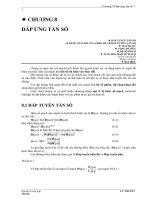
thunderstorms. Trees and buildings interfere with direct line-of-sight transmission
requirements and also block signal reception. (See Figure 10.1.)
10.9.4 GLOBAL VSAT FORUM
The Global VSAT Forum encourages development of uniform VSAT regulatory
standards, elimination of barriers to transborder broadcasts, and a framework for
streamlining the VSAT Earth station approval procedures. In addition, this Forum
supports approaches for eliminating VSAT implementation barriers, including costly
licensing fees and custom duties.
The VSAT Forum also participates in the Global Mobile Personal Communica-
tions by Satellite (GMPCS) initiative and works in concert with ETSI in developing
specifications for provisioning uniform satellite broadband interactive multimedia
services in the Ku-band and the Ka-band. Participants in the Global VSAT Forum
include satellite system integrators, equipment manufacturers, and communications
operators such as Belgacom, British Telecom, EUTELSAT, Gilat Satellite Networks,
and Hughes Network Systems. In addition, IBM Global Network, INTELSAT,
WorldCom, PanAmSat, Singapore Telecom, NEC, and NORSAT participate in Global
VSAT Forum activities.
0889Ch10Frame Page 451 Wednesday, April 17, 2002 2:58 PM
© 2002 by CRC Press LLC
10.9.5 EUROPEAN TELECOMMUNICATIONS STANDARDS INSTITUTE (ETSI)
The ETSI develops specifications in the VSAT domain for enabling seamless reception
and transmission of broadband interactive multimedia services. Moreover, the ETSI
clarifies operations of Satellite Interactive Terminals (SITs) that work in concert with
GEO satellite configurations that support downlink transmissions between the 11 and
12 GHz frequency bands and uplink transmissions between the 29 and 30 GHz fre-
quency bands. In addition, ETSI defines capabilities of SUTs (Satellite User Terminals).
SUTs work in conjunction with GEO satellite configurations that support downlink
transmissions between the 19.7 and 20.2 GHz frequency bands and uplink transmissions
between the 29.5 and 30 GHz frequency bands.
Moreover, ETSI defines capabilities of SUTs (Satellite User Terminals). SUTs
work in conjunction with GEO satellite configurations in enabling reception of
downlink transmissions in the FSS spectrum between the 19.7 and the 20.2 GHz
frequency bands and uplink transmissions between in the FSS spectrum between
the 29.5 GHz and the 30.00 GHz frequency bands.
SUTs support reception of data signals on the downlink path. SITs enable data
and audiovisual signal reception on the downlink path and provision a return channel
in support of real-time interactive satellite services on the uplink path.
10.9.6 VSAT INITIATIVES
10.9.6.1 ASTRA Satellite Services
In 2000, EMS Technologies, the Luxembourg operator of ASTRA Satellite Services,
demonstrated the capabilities of DVB (Digital Video Broadcasting) RTC (Return
FIGURE 10.1 A VSAT (Very Small Aperture Terminal) Network.
Home PC
TV
Splitter
Set-Top Box
Satellite dish
Satellite
2-way send/receive
Home
Terrestrial Internet
Network
2-way
send/receive
Dish
0889Ch10Frame Page 452 Wednesday, April 17, 2002 2:58 PM
© 2002 by CRC Press LLC
Channel via Satellite) installations in a series of pilot implementations. This DTTH
(Direct-to-the-Home) system transports voice, video, and data and radio and televi-
sion broadcasts directly to the subscriber site at 40 Mbps on the downlink path. On
the uplink path, transmissions at rates of 2 Mbps are enabled. The ASTRA Broadband
Interactive System provisions high-speed multimedia delivery via satellites in Cen-
tral and Western Europe.
10.9.6.1.1 Europe Online
Europe Online uses transponder capacity on the ASTRA Satellite System for sup-
porting voice, video, and data transmission, and providing connectivity to the Web
and narrowband and broadband public and private networks. Reception sites feature
VSAT dishes that are linked directly to digital decoders such as STBs. Europe Online
maintains a Point of Presence (PoP) site in Betzdorf that supports information
transport on the uplink. Designed for subscribers throughout the European Union,
this initiative enables operations that conform to the DVB-IP (Digital Video Broad-
cast-Internet Protocol) specification.
10.9.6.2 Hughes Network Systems (HNS) DirecDuo Service
Hughes Network Systems (HNS) DirecDuo service features an amalgam of Digital
Satellite Service (DSS) and DirecPC technologies that enable transmission rates
downstream at 400 Kbps as well as connectivity to more than 100 television chan-
nels. DirecDuo service supports satellite television broadcasts, telecourse delivery,
and Web TV programming. The reception site features VSAT dishes and digital
decoders that support interactive functions such as electronic shopping. Web service
providers and communications carriers support information transport on the uplink
path.
10.9.6.3 MedwebSAT
MedwebSAT provisions low-cost VSAT services across the United States, Mexico,
the Virgin Islands, the European Union, and Southeast Asia to rural clinics and
healthcare centers situated in communities without access to a wireline infrastruc-
ture. MedwebSAT also supports delivery of continuing medical education courses
to medical practitioners and clinical personnel at remote and isolated locations.
10.9.6.4 NORSAT VSAT Services
NORSAT VSAT services enable narrowband and broadband video, voice, and data
transmission at rates ranging from 100 Kbps to 52 Mbps. The NORSAT VSAT
platform also supports applications that include Web browsing, VoIP (voice-over-
IP), VoFR (voice-over-Frame Relay), teletraining programs, telecourses, videocon-
ferences, LAN interconnections, and television broadcasts. In addition, this platform
provides Internet, intranet, and extranet connectivity; security and surveillance appli-
cations; and electronic commerce (E-commerce) services.
The NORSAT VSAT network configuration includes earth stations that serve as
transfer points between satellite and subscriber sites. The earth station features uplink
0889Ch10Frame Page 453 Wednesday, April 17, 2002 2:58 PM
© 2002 by CRC Press LLC
and downlink equipment for signal transmission and reception. Each subscriber site
is equipped with a VSAT terminal that consists of an outdoor antenna for signal
transmission and reception and indoor equipment for enabling connectivity to an
information appliance such as a laptop or PC (Personal Computer).
NORSAT also provisions Ku-band and C-band satellite communications services
to drilling rigs, submarine vessels, offshore oil production units, ships in international
waters, terrestrial vehicles, supply vessels, and airplanes. The NORSAT satellite
tracking system monitors locations of fishing vessels, trains, ships, yachts, contain-
ers, and trucks. This service is available in the United Kingdom, Asia, and Africa,
as well as in Central, Eastern, Northern, and Western Europe.
10.9.6.5 Telesat Canada
Telesat Canada provides VSAT Direct PC services via the Nimiq, Canada’s first
broadcast satellite, for residential users that include news clips, live video feeds, and
broadcast programming. Communications service providers include the Canadian
Broadcasting Corporation, Canadian Satellite Communications, the CanWest-Global
Network, and Bell Express Vu. In addition, Telesat Canada also allows North Amer-
ican broadcasters to access the space segment in order to televise special events and
news bulletins from mobile units.
10.9.7 VSAT RESEARCH INITIATIVES
Recent research initiatives in the VSAT arena are now examined. As indicated in
these cases, the explosive growth of Web services has increased demand for delivery
of low-cost telecommunications services and applications via VSAT technology.
10.9.7.1 GloMo Program
Sponsored by DARPA (U.S. Department of Defense Research Agency), the GloMo
(Global Mobile Information Systems) Program supports initiatives that contribute
to the integration of Direct Broadcast Satellite (DBS) technology into the digital
battlefield for enabling military personnel to maintain a consistent tactical picture
in the field. In addition, the GloMo Program fosters development of network pro-
tocols and management algorithms for enabling fast transmission rates and depend-
able delivery of voice, video, and data services. Approaches for facilitating instan-
taneous access to Web resources are also explored.
10.9.7.2 European Space Agency (ESA)
The European Space Agency (ESA) supports an array of services, ranging from
spacecraft operations to educational outreach programs that promote the inclusion
of space-related topics in K–12 grades. The ESA sponsors the ARTES (Advanced
Research in Telecommunications System) Program to facilitate application devel-
opment in multimedia services, tele-healthcare, and tele-education. The ARTES
Program also enables utilization of broadband mobile services that work in conjunc-
tion with VSAT networks. To support the ARTES Program, the European Space
0889Ch10Frame Page 454 Wednesday, April 17, 2002 2:58 PM
© 2002 by CRC Press LLC
Agency (ECA) establishes partnerships with the European Commission, member
states in the European Union, government agencies, and the corporate sector.
10.9.7.2.1 ESPRESSO for Schools
The ESPRESSO for Schools project involves the participation of 200 schools in the
United Kingdom in a tele-education pilot project featuring the use of satellite delivery
for providing access to high-bandwidth applications in the classroom. Course mod-
ules support curricular enhancement.
10.9.7.2.2 EUROMEDNET
The EUROMEDNET initiative supports pilot tests and experimental activities in the
Mediterranean Region to validate satellite capabilities in provisioning telemedicine.
Clinical sites are part of the SHARED (Satellite Health Access for Remote Envi-
ronment Demonstrator) network. VSAT teleconsultations and continuing medical
education courses are provided. VSAT services also support desktop videoconfer-
encing at rates of 384 Kbps. Medical institutions taking part in EUROMEDNET
include the Habib Thameur Hospital in Tunis, the Italian Field Hospital in Durazzo,
the San Raffaele Hospital in Rome, the V. Babes Hospital in Bucharest, and the
Garibaldi Hospital in Palermo.
10.9.7.2.3 European Medical Network (EMN)
The EMN (European Medical Network) initiative supports distance learning activ-
ities and applications for medical professionals throughout the European Union. The
infrastructure for tele-education delivery includes menu-driven digital satellite
broadcasts that work in combination with Web service. Programs on cardiology and
bone nailing and plating techniques are distributed to 50 downlink sites in a series
of trials in Germany, Switzerland, France, the United Kingdom, and the Netherlands.
Participants include the European Union of Medical Specialists, Deutsche Telekom,
and IBM Global Information Services.
10.9.7.2.4 TRAPEZE
The TRAPEZE initiative fosters satellite tele-education delivery to K–12 students
in circus, carnival, and fairground communities that do not have access to wireline
communications services. The TRAPEZE infrastructure enables one-way broadband
communications on the downlink; dial-up modem connections are used for the
uplink. The West Midlands Consortium and the Stichting Rijdende School sponsor
this initiative.
10.10 SATELLITE BROADCASTS IN THE TELE-EDUCATION
DOMAIN
Satellite broadcasts support diverse applications, including military operations, envi-
ronmental monitoring, and disaster response. Satellite technology cost-effectively
delivers large quantities of information to broadly distributed reception sites. In
conventional satellite networks, numerous programs are transmitted to the satellite
and then rebroadcast to specified earth or ground stations or operators that then in turn
distribute the programs to individual viewers. For example, PBS (Public Broadcasting
0889Ch10Frame Page 455 Wednesday, April 17, 2002 2:58 PM
© 2002 by CRC Press LLC
System) distributes television programming exclusively via satellite channels. Cable
television systems receive programming from satellites as well.
Satellite communications networks also support delivery of television broadcasts
for curricular enrichment in public and private schools and universities and enable
access to movies, Broadway shows, opera performances, and symphonic concerts.
Distinctive attributes of satellite television broadcasts in the tele-education arena
are highlighted in the material that follows. Broadcasts supported by national edu-
cational broadcasting agencies and satellite program providers are initially explored.
10.10.1 SATELLITE PROGRAM PROVIDERS IN THE UNITED STATES
Satellite program providers in the United States include the American Law Network,
the Healthcare Informatics Telecom Network, and Knowledge Online. Additional
satellite program providers active in this arena also include the Public Health Train-
ing Network, America’s Continuing Education Satellite (ACE) Network, and
A*DEC, a national consortium of land grant institutions and state universities.
In an effort to create new tele-educational opportunities, educational broadcasting
agencies such as the Public Broadcasting System (PBS), American Public Television
Stations (APTS), the Corporation for Public Broadcasting (CPB), and the National
Educational Telecommunications Association (NETA) offer instructional, informa-
tional, and cultural programming rather than conventional entertainment broadcasts.
Public education satellite telecourses cover topics ranging from computers and
technology, human development, and women’s studies to philosophy and ethics,
political science, and anthropology. In the material that follows, teleprograms devel-
oped by state consortia and public and private partnerships are noted.
10.10.1.2 The PBS Adult Learning Service
Developed by PBS, the Adult Learning Service (ALS) supports satellite delivery of
college credit courses and lifelong learning programs that accommodate the needs
and objectives of adult learners. ALS educational programming is delivered to
universities, colleges, libraries, and schools nationwide in analog and digital format.
Joint Annenberg and CPB (Corporation for Public Broadcasting) initiatives that
promote the utilization of satellite television broadcasts delivering course modules
in math and science to students in primary and secondary schools are distributed by
the PBS Adult Learning Service as well. Public television stations are required to
support HDTV broadcasts by the spring of 2003.
10.10.1.3 Air Pollution Distance Learning Network (APDLN)
The Air Pollution Distance Learning Network (APDLN) is an educational satellite
broadcast network with more than 100 university and governmental affiliates across
the United States. Developed by a consortium that includes the U.S. Environmental
Protection Agency (U.S. EPA), state and local air government agencies, and North
Carolina State University, the APDLN broadcasts teleseminars and telecourses on
air quality and pollution control.
0889Ch10Frame Page 456 Wednesday, April 17, 2002 2:58 PM
© 2002 by CRC Press LLC
10.10.1.4 Executive Education Network (EXEN)
The Executive Education Network (EXEN) delivers interactive management pro-
grams via satellite to downlinks at corporate locations to facilitate executive training.
Babson College; the Harvard Business School; Carnegie Mellon, Pennsylvania State,
and Southern Methodist Universities; and the Universities of North Carolina, Penn-
sylvania, Notre Dame, and Texas develop EXEN tele-instructional programs for
distribution.
10.10.1.5 Hughes Network Systems (HNS)
Satellite operators in the educational sector such as Hughes Network Systems (HNS)
form strategic partnerships with educational institutions, government agencies, pro-
fessional associations, and nonprofit groups to facilitate production and distribution
of tele-education credit and non-credit courses relevant to school and university
curricula.
HNS supports satellite broadcasts specifically designed for the Indiana Higher
Education Telecommunications System (IHETS) and Oklahoma State and California
State Universities. HNS also provides communications capabilities for interactive
distance learning programs implemented by the Universities of Alabama, Florida,
Maryland, and Tennessee; Northern Virginia Community College; the Western Ken-
tucky Educational Technology Corporation; and the Nebraska Educational Telecom-
munications Network.
10.11 COMMERCIAL SATELLITE OPERATORS
With the popularity of satellite distance education programs, competition escalates
worldwide among commercial satellite operators interested in selling or leasing
space segments and offering partial, value-added, or full network services. Satellite
communications carriers active in the commercial satellite arena include WorldCom,
AT&T, Sprint, and Loral Corporation. Commercial satellite operators in the Asia
and Pacific Region include Korea Telecom and ChinaSat. Turksat is the commercial
satellite provider in Turkey. Deutsche Telekom offers commercial satellite services
in Germany.
10.11.1 CANAL SATELLITE (CANALSAT)
In France, Canal Satellite (CANALSAT) broadcasts interactive DTV (Digital Tele-
vision) programs and provisions access to local news, special events, weather fore-
casts, teleshopping activities, e-mail, home banking services, and tele-entertainment.
10.11.2 EUROPEAN TELECOMMUNICATIONS SATELLITE ORGANIZATION
(EUTELSAT)
EUTELSAT provides digital and analog television programs, radio broadcasts, and
multimedia services to more than 70 million homes connected to cable networks or
0889Ch10Frame Page 457 Wednesday, April 17, 2002 2:58 PM
© 2002 by CRC Press LLC
equipped with VSATs for DBS reception in the European Union, the Middle East,
Africa, and Asia. EUTELSAT also fosters development of multimedia digital plat-
forms for provisioning Web services and streaming video and audio via satellite links.
Equipment that works in concert with the EUTELSAT DVB (Digital Video
Broadcast) platform at the customer premise includes a small satellite dish, a
DVB/MPEG-2 card for a desktop computer, and a modem for transmitting informa-
tion via a PSTN or ISDN connection on the uplink.
To accommodate growing demands for satellite service between the Mediterra-
nean basin, the Europe Union, Central Asia, Russia, and Africa, EUTELSAT employs
W-series satellites for provisioning access to narrowband and broadband applications
and services in DTTH (Direct-to-the-Home) configurations. In addition, W-series
satellites provide access to mobile communications services, support Web browsing,
and enable high-speed multimedia distribution.
EUTELSAT also uses the SESAT satellite as part of its fleet for delivering a
wide array of multimedia and telecommunications services in an area of coverage
that extends from Russia to the United Kingdom. EUTELSAT satellite services are
also available in Saudi Arabia and North Africa. These satellite networks enable
high-speed Web connectivity, rural telephony service, news distribution, and DTTH
programs. Television broadcasts are distributed to MMDS providers for retransmis-
sion to subscriber sites.
EUTELSAT has used GEO satellites for supporting cellular telephony services
throughout the European Union since the 1980s. EUTELSAT currently supports
delivery of standardized Web services via digital television broadcasts that are
compliant with MPEG-2 DVB (Moving Picture Experts Group-2 Digital Video
Broadcast) specifications.
EUTELSAT also plans to deploy a new satellite called Atlantic Bird 1 for
supporting interconnectivity to wireline and wireless intra-European and trans-Atlan-
tic networks. Atlantic Bird 1 will support operations in the Ku-band and broadcasts
programs in a coverage area that includes the European Union, North Africa, North
America, South America, and the Middle East. EUTELSAT service providers include
Antenna Hungaria, Telecom Italia, British Telecom, and Easynet.
10.11.3 TELENOR BROADBAND SATELLITE SERVICES
A major satellite broadcasting service provider in Northern Europe, Telenor uses
THOR satellites and leased capacity on INTELSAT for distribution of digital video
broadcasts (DVBs). This configuration fosters transmission of sports events, news,
and instructional and entertainment programming to broadcasters and cable network
operators in Scandinavia, Eastern Europe, Africa, and the United Kingdom. The
Nittedal Earth Station near Oslo enables network management operations.
10.11.3.1 Taide Network
A Telenor subsidiary, the Taide Network provisions connectivity to major network
implementations in the United States and the European Union and delivers global
satellite services to the customer premise. The Taide infrastructure supports transmission
0889Ch10Frame Page 458 Wednesday, April 17, 2002 2:58 PM
© 2002 by CRC Press LLC
at rates reaching 155.52 Mbps (OC-3), facilitates dependable reliable voice, video,
and data distribution, and enables IP telephony, and VPN implementations.
Telenor operates the Svalbard Satellite (SvalSat) earth station situated at Plataab-
erget on the Arctic Island of Svalbard. The SvalSat earth station is the northernmost
earth station on the planet. This earth station retrieves and processes environmental
and meteorological data from Polar-Orbiting Environmental Satellites (POES) and
then transmits this data to NASA for utilization in the Mission to Planet Earth
Program.
10.12 SATELLITE NETWORK CONFIGURATIONS
The popularity of Web services drives demand for faster and more efficient access
to the Internet from any location. This demand contributes to the emergence of
mixed-mode configurations featuring satellite networks that operate in conjunction
with cable, Asynchronous Digital Subscriber Line (ADSL), Integrated Services
Digital Network (ISDN), Asynchronous Transfer Mode (ATM), and Synchronous
Optical Network (SONET) technologies and configurations.
These hybrid network configurations distribute high-speed, high-performance,
data-intensive applications, and support instantaneous and ubiquitous access to Web
resources.
As illustrated in the following initiatives sponsored by NASA (National Aero-
nautics and Space Administration), satellite configurations provide services where
terrestrial networks cannot be deployed and extend coverage of in-place landline
networks. These initiatives also demonstrate the viability of satellite configurations
in supporting point-to-point and point-to-multipoint connections, fostering commu-
nications in local and wider area environments, and enabling dependable access to
present-day and emergent multimedia services and Web resources.
10.12.1 NASA TELE-EDUCATION PROJECTS
NASA sponsors an array of tele-instruction projects that demonstrate benefits of
satellite technologies in the tele-education domain. NASA satellite initiatives in the
educational sector involve design, development, and implementation of models,
prototypes, experiments, pilot tests, and full-scale programs.
NASA also provides educational content for video and real-time educational
course; develops classroom materials for content areas in mathematics, science, and
technologies; and sponsors multidisciplinary workshops and professional develop-
ment courses for teachers in public, private, charter, and home schools. In addition,
NASA posts curricular materials, posters, brochures, fact sheets, and educational
resources for K–12 educators, and develops tele-instructional modules on topics
such as the impact of the atmosphere and the greenhouse effect on surface temper-
atures to complement classroom activities. Post-secondary institutions that take part
in NASA educational enrichment teleprograms and tele-activities include La Guardia
and Queensborough Community Colleges; Marymount and Queens Colleges; the
University of Miami; the Florida Agricultural and Mechanical University (FAMU);
and Georgetown, Dartmouth, Brown, and Southern Connecticut State Universities.
0889Ch10Frame Page 459 Wednesday, April 17, 2002 2:58 PM
© 2002 by CRC Press LLC
10.12.1.1 NASA Jason Project
The NASA Jason Project enables middle school and high school students to explore
NASA expedition sites in real-time, interact with NASA scientists, and control live-
feed video cameras. Data, video, and audio signals for Jason expeditions originate
from simultaneous live satellite broadcasts. These broadcasts are then downlinked
to primary interactive network sites (PINS) throughout the United States, Bermuda,
Mexico, and the United Kingdom. The Jason Project also sponsors Web sites that
enable students and their teachers to track NASA discoveries and participate in
online discussion groups.
10.12.1.2 NASA Passport to Knowledge Program
The NASA Passport to Knowledge program includes satellite broadcasts about Mars,
Antarctica, and the stratosphere. Designed for secondary school students and their
teachers, these programs foster telecollaboration with NASA researchers and scien-
tists and enable students, regardless of location to participate virtually in space
missions.
10.12.2 NASA RESEARCH AND EDUCATION NETWORK (NASA-NREN)
The NASA Research and Education Network (NASA-NREN) is a high-speed, high-
performance communications network testbed that fosters advanced research, next-
generation applications, and innovations in network design. The NASA-NREN test-
bed enables researchers to validate the capabilities of high-definition television
broadcasts and IPv6 services; verify QoS guarantees for transport of audio and
bandwidth-intensive still images and video-over-gigabit networks, and analyze mas-
sive datasets generated by satellite systems. In addition, the outcomes of NASA-
NREN trials and experiments in provisioning fast, dependable, and reliable through-
put; interoperable networking solutions; and access to data-intensive resources con-
tribute to development of the Next-Generation Internet (NGI) and Internet2. NASA-
NREN research findings are also available to researchers using these peer-level
networks via NGI exchanges (NGIXs) and I2 GigaPoPs (Gigabit Points of Presence).
NASA-NREN activities were initiated with the launch of the NASA ACTS
spacecraft in 1993. At the outset, the NASA-NREN testbed supported interconnec-
tivity to the National Science Foundation Network (NSFnet) and transmission rates
at 45 Mbps.
Currently enabling multimedia transport at 622.08 Mbps (OC-12), the NASA-
NREN testbed facilitates development of middleware applications that gracefully
adapt to bandwidth degradation and deployment of gigabit networks that provision
a minimum of 500 Mbps for a single desktop application. Moreover, the NASA-
NREN testbed enables utilization of IP multicasts to distribute massive datasets to
multiple NASA sites for scientific analysis and fosters implementation of sophisti-
cated hybrid satellite and terrestrial gigabit networks that contribute to innovations
in earth science, space science, aeronautics, astrophysics, astrobiology, and geophys-
ical studies. The NASA-NREN platform also supports access to still images and
0889Ch10Frame Page 460 Wednesday, April 17, 2002 2:58 PM
© 2002 by CRC Press LLC
telemetry from robotic planetary excursions, virtual participation in remote geolog-
ical experiments, and real-time transport of echocardiograms.
NASA-NREN initiatives such as the NASA ATM Research and Industrial Stud-
ies (ARIES) demonstrate capabilities of mixed-mode satellite and terrestrial net-
works in supporting emergency services in response to crisis situations and natural
disasters. NASA-NREN teletraining programs help individuals adapt to remote
environments such as those encountered in space flight. NASA-NREN pilot studies
facilitate utilization of specialized hardware, metacomputing resources, and distrib-
uted tools to support visualizations of massive datasets generated by NASA research
satellites.
In the field of earth sciences, the NASA OhioView project uses the NASA-
NREN platform to facilitate applications in agriculture, cartography, geography,
forestry, urban planning, and geology. Academic participants include Bowling Green,
Kent State, Ohio State, and Ohio Universities
The NASA Space Communications Program (SCP) supports a Web distributed
information system called the Space Internet. Every spacecraft and instrument serves
as node on the Space Internet.
10.12.2.10 Ultra-Small Aperture Terminal (USAT) Systems
Developed by the NASA ACTS (Advanced Communications Telecommunications
Satellite) Experiment Program, Ultra-Small Aperture Terminal (USAT) systems
employ the Ka-band frequencies for data transport, Web browsing, distance learning,
and interactive videoconferencing. In a series of healthcare experiments, USATs
enabled teleconsultations between patients in remote locations and physicians at key
medical centers and transmission of CAT and MRI scans via the NASA-NREN
testbed for assessment by medical specialists. These experiments verified performance
of mixed-mode satellite and terrestrial networks in provisioning access to affordable
healthcare services to individuals in medically underserved rural communities.
10.13 U.S. DEPARTMENT OF DEFENSE SATELLITE
TELEMEDICINE INITIATIVES
The U.S. Department of Defense sponsors telemedicine projects that support access
to specialty healthcare services, decrease professional isolation of rural healthcare
providers, and promote telehealthcare education and teleresearch. Sponsored by the
U.S. Department of Defense, the Telemedicine and Advanced Technology Research
Center (TATRC) provisions access to programs in telehealthcare, telemedicine, and
medical informatics. TATRC also employs satellite services to support delivery of
telemedicine treatment to U.S. military forces in Iraq, Somalia, Rwanda, Croatia,
Macedonia, Haiti, Panama, Cuba, Egypt, Russia, Sweden, Kenya, and the United
Kingdom.
The ongoing deployment of military forces contributes to the utilization of ATM
and satellite technologies for provisioning access to remote telehealthcare treatment.
As an example, medical specialists in Germany provision telemedicine services to
0889Ch10Frame Page 461 Wednesday, April 17, 2002 2:58 PM
© 2002 by CRC Press LLC