Advances in Robot Navigation Part 1 pot
Bạn đang xem bản rút gọn của tài liệu. Xem và tải ngay bản đầy đủ của tài liệu tại đây (692.95 KB, 20 trang )
ADVANCES
INROBOTNAVIGATION
EditedbyAlejandraBarrera
Advances in Robot Navigation
Edited by Alejandra Barrera
Published by InTech
Janeza Trdine 9, 51000 Rijeka, Croatia
Copyright © 2011 InTech
All chapters are Open Access articles distributed under the Creative Commons
Non Commercial Share Alike Attribution 3.0 license, which permits to copy,
distribute, transmit, and adapt the work in any medium, so long as the original
work is properly cited. After this work has been published by InTech, authors
have the right to republish it, in whole or part, in any publication of which they
are the author, and to make other personal use of the work. Any republication,
referencing or personal use of the work must explicitly identify the original source.
Statements and opinions expressed in the chapters are these of the individual contributors
and not necessarily those of the editors or publisher. No responsibility is accepted
for the accuracy of information contained in the published articles. The publisher
assumes no responsibility for any damage or injury to persons or property arising out
of the use of any materials, instructions, methods or ideas contained in the book.
Publishing Process Manager Natalia Reinić
Technical Editor Teodora Smiljanic
Cover Designer Jan Hyrat
Image Copyright VikaSuh, 2010. Used under license from Shutterstock.com
First published June, 2011
Printed in Croatia
A free online edition of this book is available at www.intechopen.com
Additional hard copies can be obtained from
Advances in Robot Navigation Edited by Alejandra Barrera
p. cm.
ISBN 978-953-307-346-0
free online editions of InTech
Books and Journals can be found at
www.intechopen.com
Contents
Preface IX
Part 1 Robot Navigation Fundamentals 1
Chapter 1 Conceptual Bases of Robot Navigation Modeling,
Control and Applications 3
Silas F. R. Alves, João M. Rosário, Humberto Ferasoli Filho,
Liz K. A. Rincón and Rosana A. T. Yamasaki
Chapter 2 Vision-only Motion Controller for Omni-directional
Mobile Robot Navigation 29
Fairul Azni Jafar, Yuki Tateno, Toshitaka Tabata,
Kazutaka Yokota and Yasunori Suzuki
Chapter 3 Application of Streaming Algorithms and DFA Learning
for Approximating Solutions to Problems
in Robot Navigation 55
Carlos Rodríguez Lucatero
Chapter 4 SLAM and Exploration using Differential Evolution
and Fast Marching 81
Santiago Garrido, Luis Moreno and Dolores Blanco
Part 2 Adaptive Navigation 99
Chapter 5 Adaptive Navigation Control for Swarms of
Autonomous Mobile Robots 101
Yasuhiro Nishimura, Geunho Lee, Nak Young Chong,
Sang Hoon Ji and Young-Jo Cho
Chapter 6 Hybrid Approach for Global Path Selection & Dynamic
Obstacle Avoidance for Mobile Robot Navigation 119
D. Tamilselvi, S. Mercy Shalinie, M. Hariharasudan and G. Kiruba
Chapter 7 Navigation Among Humans 133
Mikael Svenstrup
VI Contents
Part 3 Robot Navigation Inspired by Nature 159
Chapter 8 Brain-actuated Control of Robot Navigation 161
Francisco Sepulveda
Chapter 9 A Distributed Mobile Robot Navigation by
Snake Coordinated Vision Sensors 179
Yongqiang Cheng, Ping Jiang and Yim Fun Hu
Part 4 Social Robotics 205
Chapter 10 Knowledge Modelling in Two-Level Decision Making
for Robot Navigation 207
Rafael Guirado, Ramón González, Fernando Bienvenido and
Francisco Rodríguez
Chapter 11 Gait Training using Pneumatically Actuated
Robot System 223
Natasa Koceska, Saso Koceski, Pierluigi Beomonte Zobel and
Francesco Durante
.
Preface
Robot navigation includes different interrelated activities such as perception‐
obtainingandinterpretingsensoryinformation; exploration‐thestrategy that guides
the robot to select the next direction to go; mapping‐the construction of a spatial
representation by using the sensory information perceived; localization‐the strategy
to estimate the robot position within the sp
atial map; path planning ‐the strategy to
find a path towards a goal location being optimal or not; and path execution, where
motoractionsaredeterminedandadaptedtoenvironmentalchanges.
The book integrates results from the research work of several authors all over the
world, addressing the abovementioned activities and analyzing the critical
im
plications of dealing with dynamic environments. Different solutions providing
adaptive navigation are taken from nature inspiration and diverse applications are
describedinthecontextofanimportantfieldofstudy,socialrobotics.
Thebookincludes11chaptersorganizedwithin4partsasfollows.
RobotNavigationFundamentals
In order to contex
tualize the different approaches proposed by authors, this part
provides an overview of core concepts involved in robot navigation. Specifically,
Chapter1 introducesthe basics ofa mobile robot physicalstructure, its dynamic and
kinematic modeling, the mechanisms for mapping, localization, and trajectory
planning and reviews the state of the art of navigation methods and control
architectures which enables high degree of autonomy. Chapter 2 describes a
navigational system providing vision‐based localization and topological mapping of
theenvironment.Chapter3depictspotentialproblemswhichmightariseduringrobot
motion planning, while trying to define the appropriate sequence of movements to
achieveagoalwithinanunce
rtainenvironment.
Closing this part, Chapter 4 presents a robot navigation method combining an
exploratory strategy that drives the robot to the most unexplored region of the
environment, a SLAM algorithm to build a consistent map, and the Voronoi Fast
Marchingtechniquetoplanthetrajectoryto
wardsthegoal.
X Preface
AdaptiveNavigation
Real scenarios involve uncertainty, thus robot navigation must deal with dynamic
environments. The chapters included within this part are concerned with
environmentaluncertaintyproposingnovelapproachestothischallenge.Particularly,
Chapter 5 presents a multilayered approach to wheeled mobile robot navigation
incorporating dynamic mapping, deliberative planning, path following, and two
dist
inct layers of point‐to‐point reactive control. Chapter 6 describes a robot path
planning strategy within an indoor environment employing the Distance Transform
methodology and the Gilbert–Johnson–Keerthi distance algorithm to avoid colliding
with dynamic obstacles. This hybrid method enables the robot to select the shortest
pathtothegoaldu
ringnavigation.Finally,Chapter7proposesanadaptivesystemfor
natural motion interaction between mobile robots and humans. The system finds the
position and orientation of people by using a laser range finder based method,
estimates human intentions in real time through a Case‐Based Reasoning approach,
allowsthe robot tonavigate arounda pers
onby means ofanadaptive potential field
that adjusts according to the person intentions, and plans a safe and comfortable
trajectory employing an adapted Rapidly‐exploring Random Tree algorithm. The
robotcontrolledbythissystemisendowedwiththeabilitytoseehumansasdynamic
obstacleshavin
gsocialzonesthatmustberespected.
RobotNavigationInspiredbyNature
In this part, authors focused on nature of proposing interesting approaches to robot
navigation.Specifically,Chapter8addressesbrain interfaces‐systemsaimingtoena‐
bleuser control ofadevicebased on brain activity‐related signals. The author is con‐
cerned with brain‐computer interfaces that use non‐invasive technology, discussing
theirpotentialbenefitstothefieldofrobotnavigation,especiallyindifficultscenarios
in which the robot cannot successfully perform all functions without human assis‐
tance,suchasindangerousareaswheresensorsoralgorithmsmayfail.
On the other hand, Chapter 9 investig
ates the use of animal low level intelligence to
controlrobotnavigation.Authorstookinspirationfrominsecteyeswithsmallnervous
systems mimicking a mosaic eye to propose a bio‐mimetic snake algorithm that di‐
videstherobotpathintosegmentsdistributedamongdifferentvisionsen
sorsproduc‐
ingcollisionfreenavigation.
SocialRobotics
Oneofthemostattractiveapplicationsofroboticsis,withoutdoubt,thehuman‐robot
interactionby providing useful services. This final partincludes practicalcasesof ro‐
botsservingpeopleintwoimportantfields:guidingandrehabilitation.
In Chapter 10, authors present a social robot specif
ically designed and equipped for
human‐robotinteraction,includingallthebasiccomponentsofsensorizationandnav‐
igation within real indoor/outdoor environments, and a two‐level decision making
Preface XI
frameworktodeterminethemostappropriatelocalizationstrategy.Theultimategoal
ofthisapproachisarobotactingasaguideforvisitorsattheauthors’university.
Finally,Chapter11describesthearchitecturedesignof anexoskeletondevicefor gait
rehabilitation. It allows free leg motion while the patient walks on a treadm
ill com‐
pletely or partially supported by a suspension system. During experimentation, the
patientmovementisnaturalandsmoothwhilethelimbmovesalongthetargettrajec‐
tory.
Thesuccessfulresearchcasesincludedinthisbookdemonstratetheprogressofdevic‐
es,systems,models and architecturesinsupportingthe navigationalbe
haviorof mo‐
bilerobotswhileperformingtaskswithinseveralcontexts.Withadoubt,theoverview
of the state of the art provided by this book may be a good starting point to acquire
knowledgeofintelligentmobilerobotics.
AlejandraBarrera
Mexico’sAutonomousTechnologicalInstitute(ITAM)
Mexico
Part 1
Robot Navigation Fundamentals
1
Conceptual Bases of Robot Navigation
Modeling, Control and Applications
Silas F. R. Alves
1
, João M. Rosário
1
, Humberto Ferasoli Filho
2
,
Liz K. A. Rincón
1
and Rosana A. T. Yamasaki
1
1
State University of Campinas
2
University of São Paulo State
Brazil
1. Introduction
The advancements of the research on Mobile Robots with high degree of autonomy is
possible, on one hand, due to its broad perspective of applications and, on other hand, due
to the development and reduction of costs on computer, electronic and mechanic systems.
Together with the research in Artificial Intelligence and Cognitive Science, this scenario
currently enables the proposition of ambitious and complex robotic projects. Most of the
applications were developed outside the structured environment of industry assembly lines
and have complex goals, such as planets exploration, transportation of parts in factories,
manufacturing, cleaning and monitoring of households, handling of radioactive materials in
nuclear power plants, inspection of volcanoes, and many other activities.
This chapter presents and discusses the main topics involved on the design or adoption of a
mobile robot system and focus on the control and navigation systems for autonomous
mobile robots. Thus, this chapter is organized as follows:
• The Section 2 introduces the main aspects of the Robot design, such as: the
conceptualization of the mobile robot physical structure and its relation to the world;
the state of art of navigation methods and systems; and the control architectures which
enables high degree of autonomy.
• The Section 3 presents the dynamic and control analysis for navigation robots with
kinematic and dynamic model of the differential and omnidirectional robots.
• And finally, Section 4 presents applications for a robotic platform of Automation,
Simulation, Control and Supervision of Navegation Robots, with studies of dynamic
and kinematic modeling, control algorithms, mechanisms for mapping and localization,
trajectory planning and the platform simulator.
2. Robot design and application
The robot body and its sensors and actuators are heavily influenced by both the application
and environment. Together, they determine the project and impose restrictions. The process
of developing the robot body is very creative and defies the designer to skip steps of a
natural evolutionary process and achieve the best solution. As such, the success of a robot
Advances in Robot Navigation
4
project depends on the development team, on the clear vision of the environment and its
restrictions, and on the existence purpose of the robot. Many are the aspects which
determine the robot structures. The body, the embedded electronics and the software
modules are the result of a creativity intensive process of a team composed by specialists
from different fields. On the majority of industrial applications, a mobile robot can be reused
several times before its disposal. However, there are applications where the achievement of
the objectives coincides with the robot end of life. Such applications may be the exploration
of planets or military missions such as bomb disposal.
The project of a robot body is initially submitted to a critical analysis of the environment and
its existence purposes. The environment must be studied and treated according to its
complexity and also to the previous knowledge about it. Thus, the environment provides
information that establishes the drive system in face of the obstacles it will find. Whether it
is an aerial, aquatic or terrestrial, it implies the study of the most efficient structure for the
robot locomotion trough the environment. It is important to note that the robot body project
may require the development of its aesthetics. This is particularly important to robots that
will subsist with humans.
The most common drive systems for terrestrial mobile robots are composed by wheels, legs
or continuous track. The aerial robots are robotic devices that can fly in different
environment; generally this robots use propellers to move. The aquatic robots can move
under or over water. Some examples for these applications are: the AirRobot UK®
(Figure 1a), an aerial quad rotor robot (AirRobot, 2011); the Protector Robot, (Figure 1b),
built by Republic of Singapore with BAE Systems, Lockheed Martin and Rafael Enterprises
(Protector, 2010); and the BigDog robot (Figure 1c), created by Boston Dynamics (Raibert et
al., 2011), a robot that walks, runs and climbs in different environment.
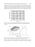
a) b) c)
Fig. 1. Applications of Robot Navigation: a) Aerial Robot, b) Aquatic Robot, c)Terrestrial Robot
There are two development trends: one declares that the project of any autonomous
system must begin with an accurate definition of its task (Harmon, 1987), and the other
proclaims that a robot must be able to perform any task in different environments and
situations (Noreils & Chatila, 1995). The current trend on industry is the specialization of
robot systems, which is due by two factors: the production cost of general purpose robot
is high, as it requires complex mechanical, electronic and computational systems; and a
robot is generally created to execute a single task – or a task “class” – during its life cycle,
as seem in Automated Guidance Vehicles (AVG). For complex tasks that require different
sensors and actuators, the current trend is the creation of a robot group where each
member is specialist on a given sub-task, and their combined action will complete the
task.
Conceptual Bases of Robot Navigation Modeling, Control and Applications
5
2.1 Robot Navigation systems and methods
Navigation is the science or art of guiding of a mobile robot in the sense of how travel
through the environment (McKerrow, 1991). The problems related to the navigation can be
briefly defined in three questions: “Where am I”, “Where am I going” and “How do I get
there?” (Leonard & Durrant-White, 1991). The first two questions may be answered by an
adequate sensorial system, while the third question needs an effective planning system. The
navigation systems are directly related to the sensors available on the robot and the
environment structure. The definition of a navigation system, just like any aspect of the
robot we have seem so far, is influenced by the restrictions imposed by both the
environment and the robot very purpose. The navigation may be obtained by three systems:
a coordinates based system, a behavior based system and a hybrid system.
The coordinates based system, like the naval navigation, uses the knowledge of one’s position
inside a global coordinate system of the environment. It is based on models (or maps) of the
environment to generate paths to guide the robot. Some techniques are Mapping (Latombe,
1991), Occupancy Grid Navigation (Elfes, 1987), and Potential Fields (Arkin et al., 1987). The
behavior based system requires the robot to recognize environment features through its
sensors and use the gathered information to search for its goals. For example, the robot must
be able to recognize doors and corridors, and know the rules that will lead it to the desired
location. In this case, the coordinate system is local (Graefe & Wershofen, 1991).
Information about the statistical features of the environment is important to both cited
systems. The modeling of the environment refers to the representation of objects and the
data structure used to store the information (the maps). Two approaches for map building
are the geometric and phenomenological representation. Geometric representation has the
advantage of having a clear and intuitive relation to the real world. However, the geometric
representation has no satisfactory representation of uncertain geometries, as well as is not
clear if knowing the world shape is really useful (Borenstein et al., 1995). The
phenomenological representation is an attempt to overcome this problem. It uses a
topological representation of the map with relative positioning which is based on local
reference frames to avoid the accumulation of relative errors. Whenever the uncertainty
grows too high, the robot sets a new reference frame; on the other hand, if the uncertainty
decreases, the robot may merge frames. This policy keeps the uncertainty bound locally
(Borenstein et al., 1995, as cited in Engelson & McDermott, 1992).
Mobile robots can navigate using relative or absolute position measures (Everett, 1995).
Relative positioning uses odometry or inertial navigation. Odometry is a simple and
inexpensive navigation system; however it suffers from cumulative errors. The inertial
navigation (Barshan & Durrant-White, 1995) uses rotation and acceleration measures for
extracting positioning information. Barshan and Durrant-White (1995) presented an inertial
navigation system and discusses the challenges related to mobile robot movement based on
non-absolute sensors. The most concerning issue is the accumulation of error found in
relative sensors. The absolute positioning system can use different kinds of sensors which
are divided in four groups of techniques: magnetic compass, active beacons, landmark
recognition and model matching. Magnetic compasses are a common kind of sensor which
uses Earth’s natural electromagnetic field and does not require any change on the
environment to be able to navigate through the world. Nevertheless, magnetic compasses
readings are affected by power lines, metal structures, and even the robot movement, which
introduces error to the system (Ojeda & Borenstein, 2000).
Advances in Robot Navigation
6
Active beacons are devices which emits a signal that is recognized by the robot. Since the
active beacons are placed in known locations, the robot is able to estimate its position using
triangulation or trilateration methods. In a similar fashion, the landmark system uses
features of the environment to estimate its position. These landmarks may be naturally
available on the environment, such as doors, corridors and trees; or they can be artificially
developed and place on the environment, such as road signs. On one hand, natural
landmarks do not require any modification in the world, but may not be easily recognized
by the robot. On the other hand, artificial landmarks modifies the environment, but offer
best contrast and are generally easier to be recognized. Nonetheless, the main problem with
landmarks is detecting them accurately through sensorial data. Finally, the model matching
technique uses features of the environment for map building or to recognize an
environment within a previously known map. The main issues are related to finding the
correspondence between a local map, discovered with the robot sensors, and a known
global map (Borenstein et al., 1995).
Inside model matching techniques, we can point out the Simultaneous Localization and
Mapping (SLAM). The SLAM addresses to the problem of acquiring the map of the
environment where the robot is placed while simultaneously locating the robot in relation to
this map. For this purpose, it involves both relative and absolute positioning techniques.
Still, SLAM is a broad field and leaves many questions unanswered – mainly on SLAM in
non-structured and dynamic environments (Siciliano & Khatib, 2008).
Other approach for mobile robot navigation is the biomimetic navigation. Some argue that
the classic navigation methods developed on the last decades have not achieved the same
performance flexibility of the navigation mechanisms of ants or bees. This has led
researchers to study and implement navigation behaviors observed on biological agents,
mainly insects. Franz and Mallot (Franz & Mallot, 2000) surveyed the recent literature on
the phenomena of mobile robot navigation. The authors divide the techniques of
biomimetic navigation into two groups: local navigation and path discovery. The local
navigation deals with the basic problems of navigation, as the obstacle avoidance and
track following, to move a robot from a start point (previously know or not) to a known
destination inside the robot vision field. Most of recent researches objectives are to test the
implementation of biological mechanisms, not to discover an optimal solution for a
determined problem.
The navigation of mobile robots is a broad area which is currently the focus of many
researchers. The navigation system tries to find an optimal path based on the data acquired
by the robot sensors, which represents a local map that can be part, or not, of a global map
(Feng & Krogh, 1990). To date, there is still no ideal navigation system and is difficulty to
compare the results of researches, since there is a huge gap between the robots and the
environment of each research (Borenstein et al., 1995). When developing the navigation
system of a mobile robot, the designer must choose the best navigation methods for the
robot application. As said by Blaasvaer et al. (1994): “each navigation context imposes
different requirements about the navigation strategy in respect to precision, speed and
reactivity”.
2.2 Sensors
The mobile robots need information about the world so they can relate themselves to the
environment, just like animals. For this purpose, they rely on sensor devices which
Conceptual Bases of Robot Navigation Modeling, Control and Applications
7
transform the world stimuli into electrical signal. These signals are electrical data which
represents state of about the world and must be interpreted by the robot to achieve its goals.
There is wide range of sensors used to this end.
Sensors can be classified by some features as the application, type of information and signal.
As for their usage, sensors can be treated as proprioceptive or exteroceptive. Proprioceptive
sensors are related to the internal elements of the robot, so they monitor the state of its inner
mechanisms and devices, including joints positions. In a different manner, exteroceptive
sensors gather information from the environment where the robot is placed and generally
are related to the robot navigation and application. From the viewpoint of the measuring
method, sensors are classified into active and passive sensors. Active sensors apply an
known interfering signal into the environment and verify the effect of this signal into the
world. Contrastingly, passive sensors does not provoke any interfering signal to measure
the world, as they are able to acquire “signals” naturally emitted by the world. Sensors can
also be classified according to the electrical output signal, thus are divided into digital and
analog sensors. In general, sensorial data is usually inaccurate, which raises the difficulty of
using the information provided by them.
The sensor choice is determined by different aspects that may overlap themselves or are
conflicting. The main aspects are: the robot goals, the accuracy of the robot and environment
models, the uncertainty of sensor data, the overall device cost, the quantity of gathered
information, the time available for data processing, the processing capabilities of the
embedded computer (on-board), the cost of data transmission for external data processing
(off-board), the sensors physical dimension in contrast to the required robot dimension, and
the energy consumption.
In respect to the combined use of sensor data, there is not a clear division of data integration
and fusion processes. Searching for this answer, Luo (Luo & Kay, 1989) presented the
following definition: “The fusion process refers to the combination of different sensors
readings into an uniform data structure, while the integration process refers to the usage of
information from several sensor sources to obtain a specific application”.
The arrangement of different sensors defines a sensor network. This network of multiple
sensors when combined (through data fusion or integration) functions as a single, simple
sensor, which provides information about the environment. An interesting taxonomy for
multiple sensor networks is presented by Barshan and Durrant-White (1995) and
complemented by Brooks and Iyengar (1997): Complementary: There is no dependency
between the sensors, however they can be combined to provide information about a
phenomena, Competitive: The sensors provides independent measures of the same
phenomena, which reduces the inconsistency and uncertainties about of the information,
Cooperative: different sensors which works together to measure a phenomena that a single
sensor is not capable of measuring, Independent: independent sensors are those of which
measures does not affect or complement other sensor data.
2.2.1 Robot Navigation sensors
When dealing with Robot Navigation, sensors are usually used for positioning and obstacle
avoidance. In the sense of positioning, sensors can be classified as relative or absolute
(Borenstein et al., 1995). Relative positioning sensors includes odometry and inertial
navigation, which are methods that measures the robot position in relation to the robot initial
point and its movements. Distinctively, absolute positioning sensors recognize structures on
the environment which position is known, allowing the robot to estimate its own position.
Advances in Robot Navigation
8
Odometry uses encoders to measure the rotation of the wheels, which allows the robot to
estimate its position and heading according to its model. It’s the most available navigation
system due to its simplicity, the natural availability of encoders, and low cost.
Notwithstanding, this is often a poor method for localization. The rotation measuring may
be jeopardized by the inaccuracy of the mechanical structure or by the dynamics of the
interaction between the tire and the floor, such as wheel slippage. On the other hand, the
position estimation takes into account all past estimations - it integrates the positioning. This
means that the errors are also integrated and will grow over time, resulting in a high
inaccurate system. Just like odometry, inertial navigation, which uses gyroscopes and
accelerometers to measure rotation and acceleration rates, is highly inaccurate due to its
integrative nature. Other drawback is the usual high costs of gyroscopes and accelerometers.
The heading measure provided by compasses represents one of the most meaningful
parameters for navigation. Magnetic compasses provides an absolute measure of heading
and can function on virtually all of Earth surface, as the natural magnetic field of Earth is
available on all of its surface. Nevertheless, magnetic compasses are influenced by metallic
structures and power lines, becoming highly inaccurate near them.
Other group of sensors for navigation are the active beacons. These sensors provide absolute
positioning for mobile robots through the information sent by three or more beacons. A
beacon is a source of known signal, as structured light, sound or radio frequencies. The
position is estimated by triangulation or trilateration. It is a common positioning system
used by ships and airplanes due to its accuracy and high speed measuring. The Global
Positioning System (GPS) is an example of active beacon navigation system.
The map based positioning consists in a method where robots use its sensors to create a
local map of the environment. This local map is compared to a known global map stored on
the robot memory. If the local map matches a part of the global map, then the robot will be
able to estimate its position. The sensors used in this kind of system are called Time-of-
Flight Range Sensors, which are active sensors that measures the distance of nearby objects.
Some widely used sensors are sonars and LIDAR scanners (Kelly, 1995).
As sensor industry advances in high speed, this chapter does not cover all sensors available in
the market. There are other sensors which may be used for navigation, as odor sensors (Russel,
1995, Deveza et al., 1994) for active beacon navigation, whereas the beacon emits an odor.
2.3 Control architectures for navigation
A mobile robot with a high degree of autonomy is a device which can move smoothly while
avoiding static and mobile obstacles through the environment in the pursuit of its goal
without the need for human intervention. Autonomy is desirable in tasks where human
intervention is difficult (Anderson, 1990), and can be accessed through the robot efficiency
and robustness to perform tasks in different and unknown environments (Alami et al.,
1998), or the ability to survive in any environment (Bisset, 1997), responding to expected and
unexpected events both in time and space, with the presence of independent agents or not
(Ferguson, 1994).
To achieve autonomy, a mobile robot must use a control architecture. The architecture is
closely linked to how the sensor data are handled to extract information from the world and
how this information is used for planning and navigating in pursuit of the objectives,
besides involving technological issues (Rich & Knight, 1994). It is defined by the principle of
operation of control modules, which defines the functional performance of the architecture,
the information and control structures (Rembold & Levi, 1987).