Advances in Robot Navigation Part 3 ppt
Bạn đang xem bản rút gọn của tài liệu. Xem và tải ngay bản đầy đủ của tài liệu tại đây (5.3 MB, 20 trang )
2
Vision-only Motion Controller for
Omni-directional Mobile Robot Navigation
Fairul Azni Jafar
1
, Yuki Tateno
1
, Toshitaka Tabata
1
,
Kazutaka Yokota
1
and Yasunori Suzuki
2
1
Graduate School of Engineering, Utsunomiya University,
2
Toyota Motor Corporation
Japan
1. Introduction
A major challenge to the widespread deployment of mobile robots is the ability to function
autonomously, learning useful models of environmental features, recognizing
environmental changes, and adapting the learned models in response to such changes.
Many research studies have been conducted on autonomous mobile robots that move by its
own judgment. Generally, in many research studies of autonomous mobile robotics, it is
necessary for a mobile robot to know environmental information from sensor(s) in order to
navigate effectively. Those kinds of robots are expected for automation in order to give
helps and reduce humans work load.
In previous research studies of autonomous mobile robots navigation, accurately control on
the robot posture with a possibility of less error, was always required. For that, it is
necessary to provide accurate and precise map information to the robot which makes the
data become enormous and the application become tedious. However, it is believed that for
a robot which does not require any special accuracy, it can still move to the destination like
human, even without providing any details map information or precise posture control.
Therefore, in this research study, a robot navigation method based on a generated map and
vision information without performing any precise position or orientation control has been
proposed where the map is being simplified without any distance information being
mentioned.
In this work we present a novel motion controller system for autonomous mobile robot
navigation which makes use the environmental visual features capture through a single
CCD camera mounted on the robot.
The main objective of this research work is to introduce a new learning visual perception
navigation system for mobile robot where the robot is able to navigate successfully towards
the target destination without obtaining accurate position or orientation estimation. The
robot accomplishes navigation tasks based on information from images captured by the
robot.
In the proposed approach, the robot identifies its own position and orientation based on the
visual features in the images while moving to the desired position. The study focused on
developing a navigation system where the robot will be able to recognize its orientation to
Advances in Robot Navigation
30
the target destination through the localization process without any additional techniques or
sensors required. It is believed that by having this kind of navigation system, it will
minimize the cost on developing the robot and reduce burdens on the end-user.
For any robot which is developed for elementary missions such as giving a guide in an
indoor environment or delivering objects, a simple navigation system will be good enough.
The robot for these tasks does not require any precise position or orientation identification.
Instead, qualitative information regarding the robot posture during the navigation task that
is sufficient to trigger further actions is needed. As it is not necessary for the robot to know
the exact and absolute position, a topological navigation will be the most appropriate
solution.
This research work developed a visual perception navigation algorithm where the robot is
able to recognize its own position and orientation through robust distinguishing operation
using a single vision sensor. When talking about robot, precise and accurate techniques
always caught our mind first. However, our research group proved that robots are able to
work without precise and accurate techniques provided. Instead, robust and simple learning
and recognizing methods will be good enough.
The remainder of this chapter is organized as follows. The next section will explain the
topological navigation method employed in the research work. Section 3 gives an overview
of the related work. In section 4, the omni-directional robot is introduced. Section 5 explains
the environmental visual features used in the approach, section 6 describe the evaluation
system of neural network, and section 7 details the motion control system. We conclude
with an overview of experimental results (section 8) and a conclusion (section 9).
2. Topological navigation
The proposed navigation method presented here uses a topological representation of the
environment, where the robot is to travel long distances, without demanding accurate
control of the robot position along the path. Information related to the desired position or
any positions that the robot has to get through is acquired from the map.
The proposed topological navigation approach does not require a 3D model of the
environment. It presents the advantage of working directly in the sensor space. In this case,
the environment is described by a topological graph. Each node corresponds to a description
of a place in the environment obtained using sensor data, and a link between two nodes
defines the possibility for the robot to move autonomously between two associated
positions.
The works presented here require a recording run before the robot navigate in an
environment, in order to capture representative images which are associated with the
corresponding nodes (places).
An advantage of the proposed approach is that the robot does not have to ‘remember’ every
position (image) along the path between two nodes. During the recording run, the robot will
only capture images around the corresponding node. This exercise will help to reduce the
data storage capacity.
At the end of the recording run, a topological map of the environment will be build by the
robot. Data of visual features obtained from the images of each node are used as instructor
data and a neural network (NN) data is produced for each node after trained by NN, before
the actual navigation is conducted in the environment.
Vision-only Motion Controller for Omni-directional Mobile Robot Navigation
31
The topological navigation approach here allows the distance between nodes to be far from
each other. The topological map in this approach may have only a few nodes as distance
between each node can be quite far. Each node corresponds to a description of a place in the
environment obtained using sensor data.
When the robot is moving to the target destination during autonomous run, it will first
identify its own position. By knowing its own starting node, the robot will be able to plan
the path to move to the target position and obtain the information about the next node from
the map. Based on the information, the robot will start moving until it is able to localize that
it has arrived at the next node. When the robot find that it is already at the next node, it will
then obtain information for the next moving node from the map and start moving toward it.
This action will be repeatedly carried out until the robot arrives at the desired destination.
An overview of the navigation method is presented in Fig. 1.
Fig. 1. Overview of the navigation process
In the localization process performed during navigating towards the target destination, the
robot compares the extracted visual features from the image captured during the robot
movement, with the stored visual features data of the target destination using NN. The NN
output result will lead to the knowledge of whether the robot is already arriving near the
respective node or not.
In this research study, a robust navigation method where the robot will take advantage of
the localization process not only to identify its own position but also the orientation is
proposed. By applying this method on the robot, it is believed that the robot is able to
correct its own pose and navigate towards the target destination without loosing the
direction while moving to the target destination.
2.1 Map information
The representations of large-scale spaces that are used by humans seem to have a
topological flavour rather than a geometric one (Park & Kender, 1995). For example, when
Advances in Robot Navigation
32
providing directions to someone in a building, directions are usually of the form "go straight
to the hall, turn left at the first corner, use the staircase on your right," rather than in
geometric form.
When using a topological map, the robot's environment is represented as an adjacency
graph in which nodes represent places (that the robot needs to identify in the environment)
and arcs stand for the connections between places. A link (show by the arc) on the
topological map means that the robot can successfully travel between the two places
(landmarks). A link can only be added to the map if the robot has made the corresponding
journey. In some instances the links are established at the same time as the places are
identified. Evidence has been provided that localization based on topological map, which
recognizes certain spots in the environment, is sufficient to navigate a mobile robot through
an environment.
The use of topological maps (graphs) has been exploited by many robotic systems to
represent the environment. A compact topological map with fewer locations requires less
memory and allow for faster localization and path planning. Topological representations
avoid the potentially massive storage costs associated with metric representations. In order
to reach the final goal, the navigation problem is decomposed into a succession of sub goals
that can be identified by recognizable landmarks. An example of topological map is shown
in Fig. 2.
Fig. 2. A topological map of landmarks in the city of Utsunomiya, Japan
3. Related work
An intelligent robot navigation system requires not only a good localization system but also
a dexterous technique to navigate in environment. The mobile robot has to be able to
determine its own position and orientation while moving in an environment in order for the
robot to follow the correct path towards the goal. Most current techniques are based on
complex mathematical equations and models of the working environment, however
following a predetermined path may not require a complicated solution.
Applications of additional sensors to control robot posture have been widely introduced
(Morales et al., 2009). Conversely, in the approach introduced in this research work, there is
no application of additional sensor to control the orientation of the robot. The only sensor
that is used in the robot system is vision sensor. Many researchers presented methods of
Vision-only Motion Controller for Omni-directional Mobile Robot Navigation
33
controlling robot pose by combining the problem with navigation towards the goal using
only vision sensor, where visual servoing is most popular.
In a research work introduced by Vasallo et al. (Vasallo et al., 1998), the robot is able to
correct its own orientation and position through a vanishing point calculated from the
corridor guidelines where the robot is navigating. The method allows the robot to navigate
along the centre of the corridor, where the progress along the path (links) is monitored using
a set of reference images. These images are captured at selected positions along the path.
The robot will be able to determine its own position through a comparison between the
acquired image and the reference image set. They used SSD (sum of squared differences
metric) method to perform the comparison. In these research works, they separated the task
on detecting position and orientation. In addition, the methods require tedious techniques
for both localization and navigation tasks in order to control the robot precisely from losing
the actual direction.
Mariottini et al. (Mariottini et al., 2004) employed a visual servoing strategy for holonomic
mobile robot based on epipolar geometry retrieved from current and desired image grabbed
with the on-board omnidirectional camera to control the pose of the robot during
navigation. Their servoing law is divided in two independent steps, dealing with the
compensation, respectively, of rotation and translation occurring between the actual and the
desired views. In the first step a set of bi-osculating conics, or bi-conics for short, is
controlled in order to gain the same orientation between the two views. In the second step
epipoles and corresponding feature points are employed to execute the translational step
necessary to reach the target position.
There is a method introduced by Goedeme et al. (Geodome et al., 2005) which is comparable
to the proposed approach. They developed an algorithm for sparse visual path following
where visual homing operations are used. In this research work, they focus on letting the
robot to re-execute a path that is defined as a sequence of connected images. An epipolar
geometry estimation method is used to extract the position and orientation of the target
during navigating towards the target point. The epipolar geometry calculation is done based
on visual features found by wide baseline matching. Information obtained from the epipolar
geometry calculation enables the robot to construct a local map containing the feature world
positions, and to compute the initial homing vector. However, the method of using epipolar
geometry requires difficult computation tasks.
In contrast to the approach introduced by Geodome the autonomous run operation in the
proposed navigation method in this research work is straightforward and does not comprise
any complicated tasks. In the work done by Geodome, the robot needs to perform an
initialization phase in order to calculate the epipolar geometry between starting position
and the target position. The robot will have to extract a trackable feature to be use as a
reference during driving in the direction of the homing vector. In the tracking phase
performed after the initialization phase, the feature positions of a new image are tracked,
and thus the robot position in the general coordinate system is identified through the
epipolar geometry measurements. The tasks perform by the robot in this approach are
rather complicated. Dissimilar to this method, the robot in the proposed approach identifies
its own starting position and immediately moves towards the target destination. All the
identification works are done directly based on the environmental visual features explained
in section 5. Moreover, the robot in the proposed approach does not have to measure the
distance to move to the following place.
Advances in Robot Navigation
34
In spite of that, all the studies introduced in the literature have been a very successful
achievement. However, they require complicated techniques to let the robot identify its own
position and to control the robot from losing the actual direction during navigating towards
the target destination. In the proposed approach here, a simple yet robust technique for both
robot localization and navigation is developed with the main objective is to let the robot
arrive safely at the proximity of the target destination. An emphasis is put on situations
where robot does not require accurate localization or precise path planning but is expected
to navigate successfully towards the destination. The approach also does not aim for
accurate route tracing.
With this consideration, a robust navigation method for autonomous mobile robot where
the robot will take advantage of the localization process not only to identify its own position
but also the orientation is proposed. It is believed that both robot position and orientation
can be identified through a single technique, and it is not necessary to have separate
technique to control the robot orientation. A method with less technique required for
identifying both position and orientation, will reduce the robot navigation time.
The proposed method is based on environmental visual features evaluated by neural
network. By applying this method on the robot, it is believed that the robot is able to correct
its own pose and navigate towards the target destination without losing the direction while
moving to the target destination.
In a simple navigation method which does not require for any precise or accurate techniques
as introduced in this research study, the robot programming will become less tedious. The
method that is introduced in this research work will able to help minimizing cost in robot
development.
An earlier contribution in the area of mobile robot navigation using image features and
NN is the work of Pomerleau (Pomerleau, 1989)}. It was then followed by many other
research works where they have successively let the robot navigate in the human working
environments (Burrascano et al., 2002; Meng & Kak, 1993; Na & Oh, 2004; Rizzi et al.,
2002).
One very similar research work with the proposed method is the one introduced by Rizzi
et al. (Rizzi et al., 2002)}. The robot in this approach uses an omnidirectional image sensor
to grab visual information from the environment and applies an artificial NN to learn the
information along the path. The visual information, which composed of RGB color values,
is preprocessed and compacted in monodimensional sequences called Horizon Vectors
(HV), and the path is coded and learned as a sequence of HVs. The system in this
approach guides the robot back along the path using the NN position estimation and
orientation correction. The orientation identification is performed by a circular correlation
on the HVs.
4. The omni-directional mobile robot
The autonomous mobile robot system in this research study is based on the Zen360 omni-
directional mobile robot which was developed by RIKEN Research Centre (Asama et al.,
1996). The driven mechanism part of the robot was developed by the previous members of
the Robotics and Measurement Engineering Laboratory of Utsunomiya University. The
robot consists of a computer and a CCD colour camera. Each image acquired by the system
has a resolution of 320 x 240. The entire system is shown in Fig. 3.
Vision-only Motion Controller for Omni-directional Mobile Robot Navigation
35
Fig. 3. The Omni-directional mobile robot
Model
Sony XC999
Heel Angle
106.30°
Tilt Angle
79.18°
Resolution
320 X 240 [pixel]
Table 1. Camera specification
The robot has 4 wheels where the wheel diameter is 360mm on the circumference of circle
with the rotating shaft is pointing towards the centre. The robot mechanism possesses 2
translatory DOF and 1 rotating DOF, which in total of 3 DOF (Degree of Freedom).
During the actual locomotion, the opposing 2 wheels are rotating on the same translation
direction derived through the activation of the 2 wheels bearing, therefore a stabilize
translation motion towards x axis or y axis is feasible. Furthermore, a turning motion is also
feasible due to the same direction driven of the 4 wheels.
Fig. 4. Robot wheel with free rollers
Under ordinary circumstances, the arranged wheels become resistance to the travelling
direction and the vertical direction. However, there are free rollers fixed on the wheel
periphery of all the wheels as shown in Fig. 4, where it reduced the resistance on the wheel
rotating direction and allowed for a smooth movement. Each wheel is built up from 6 big
free rollers and 6 small free rollers. The two type of free rollers are arranged 30[deg] in angle
alternately, and the free roller outer envelope form the outer shape of the wheel. With this
Free roller - Small
Free roller - Big
W
heel outer view
W
heel actual view
Movement mechanism
top view
Advances in Robot Navigation
36
condition, the robot is able to perform feasible omni-directional locomotion where it can
move in all directions without affecting its posture.
5. Features extraction
Feature extraction is a process that begins with feature selection. The selected features will
be the major factor that determines the complexity and success of the analysis and pattern
classification process. Initially, the features are selected based on the application
requirements and the developer's experience. After the features have been analyzed, with
attention to the application, the developer may gain insight into the application's needs
which will lead to another iteration of feature selection, extraction, and analysis. When
selecting features, an important factor is the robustness of the features. A feature is robust if
it will provide consistent results across the entire application domain.
5.1 Colour features
The concept of using colour histograms as a method of matching two images was pioneered
by Swain and Ballard (Swain & Ballard, 1991). A number of research works also use colour
histogram in their method for robot localization (Kawabe et al., 2006; Rizzi & Cassinis, 2001;
Ulrich & Nourbakhsh, 2000). These research works previously verified that colour can be
use as the features in mobile robot localization. However, unlike those studies, we examine
all the colours in an image, and use their dispositions, rather than histograms, as features.
In examining the colour, CIE XYZ colour scheme is use as it can be indicated in x and y
numerical value model. CIE XYZ considered the tristimulus values for red, green, and blue
to be undesirable for creating a standardized colour model. They used a mathematical
formula to convert the RGB data to a system that uses only positive integers as values.
In the proposed method, the CIE chromaticity diagram is separate into 8 colours with a non-
colouring space at the centre. It is regarded that those colours which are located in the same
partition as the identical colour. The separation of chromaticity diagram is shown in Fig. 5.
0.8
0.80
x
y
0.8
0.80
x
y
y=22.667x-6.715
y=2.867x-0.578
y=1.290x-0.168
y=9.000x+3.098
y=2.455x+1.070
y=0.409x+0.180
(x-0.31)+(y-0.31)=(0.066)
2
22
y=0.633x+0.504
y=0.450x+0.168
0.8
0.80
x
y
0.8
0.80
x
y
y=22.667x-6.715
y=2.867x-0.578
y=1.290x-0.168
y=9.000x+3.098
y=2.455x+1.070
y=0.409x+0.180
(x-0.31)+(y-0.31)=(0.066)
2
22
(x-0.31)+(y-0.31)=(0.066)
2
22
y=0.633x+0.504
y=0.450x+0.168
Fig. 5. Separating the chromaticity diagram into 8 colour partitions
Colours in an image are considered black when the lightness of the colour is low. It is
necessary to take these circumstances into consideration when applying colour features.
Therefore, luminosity L is applied to classify between black and the primary colour of each
partition in the separated chromaticity diagram. L is presented as follow;
L = 0.299R + 0.597G + 0.114B
(1)
Vision-only Motion Controller for Omni-directional Mobile Robot Navigation
37
We also use the luminosity to classify the non-coloring space into white, grey and black
color as we learned that the degree in lightness in the non-coloring space is changing
gradually from white to black through grey color.
L≥
50 is classify as white and black for L<35 at the non-coloring space of x=0.31 and y=0.31.
Grey color is considered when 50>L>35. For other partitions, black color is considered when
L≤
10. The value for L in this approach is determined empirically.
Formulating a simple way using the details of colour information, by roughly separating the
colours into 11 classifications as explained above is considered.
Pixels whose colours fall into one colour domain are considered to have the same colour.
Through this, the colour disposition in a captured image is evaluated based on area ratio in
the entire image and coordinates of the centre of area (x and y coordinates) of each 10
colours in the entire image, which means total of 30 data of visual features can be acquire
from colour features.
5.2 Shape features
A shape is made when the two ends of a line meet. Some shapes have curved lines while
other shapes may have straight lines. For example, a wheel has a shape made from a curved
line. One kind of shape is called geometric. Geometric shapes are simple shapes that can be
drawn with straight lines and curves, for example a desk. The work in this research study is
dealing with lines and points which are connected through the lines, in term of shape
feature.
Edge detection methods are used as a first step in the line detection process. Edge detection
is also used to find complex object boundaries by marking potential edge points
corresponding to places in an image where rapid changes in brightness occur. After these
edge points have been marked, they can be merged to form lines and object outlines.
In the proposed approach, the edge extraction is carried out based on a simple gradient
operation using Robert operator. The original colour image is converted to gray level and
then normalized so that the range of gray value is within [0,255]. From this, lines in an
image can be extracted through the edge extraction process.
Fig. 6. Extracting lines and connecting points
Advances in Robot Navigation
38
When further image processing done on the extracted edges, points which are connected
through the lines can be extracted and together with the extracted lines, they can be use as
information to recognize a place. The processes on extracting the points include noise
elimination, expansion and finish up with a thinning process. These processes can be seen in
Fig. 6. From the extracted connecting points and lines, it is able to acquire 2 data of visual
features, which consist;
• Ratio of the lines in the entire image
• Ratio of the connecting points in the entire image
5.3 Visual features data
An example of colour separation work and shape (lines and connecting points) extraction
work which is done on an image is shown in Fig. 7.
Original image Color separation Shape extraction
Fig. 7. Example of colour separation work and shape extraction work carried out on an
image
Based on the extraction process which explained earlier, each captured image (either for
the database data or for the position identification process) will produce a set of visual
features data after going through the features extraction processes. The visual features data
possess a total of 35 data where 33 data are from the colour features and another 2 data are
from the shape features data. The data set can be seen in Table 2. C in Table 2 is colour area
ratio, x and y are the coordinates of the colour area ratio, while S is representing the shape
features.
C[0] C[1] C[2] C[3] C[4] C[5] C[6] C[7] C[8] C[9]
x[0] x[1] x[2] x[3] x[4] x[5] x[6] x[7] x[8] x[9]
y[0] y[1] y[2] y[3] y[4] y[5] y[6] y[7] y[8] y[9]
S[1] S[2] S[3] S[4] S[5] S[6] S[7] S[8] S[9] S[10]
S[11]
Table 2. Architecture of the visual features data
6. Evaluation system
Neural networks (NN) are about associative memory or content-addressable memory. If content
is given to the network, then an address or identification will be return back. Images of
object could be storage in the network. When image of an object is shown to the network, it
will return the name of the object, or some other identification, e.g. the shape of the object.
Vision-only Motion Controller for Omni-directional Mobile Robot Navigation
39
A NN is a massive system of parallel-distributed processing elements (neurons) connected
in a graph topology. They consist of a network of processors that operate in parallel. This
means they will operate very fast. To date, the most complex NN that operate in parallel
consist of a few hundred neurons. But the technology is evolving fast. To recognize images,
one needs about one processor per pixel. The processors, also called neurons, are very
simple, so they can be kept small.
NN will learn to associate a given output with a given input by adapting its weight. The
weight adaptation algorithm considered here is the steepest descent algorithm to minimize a
nonlinear function. For NN, this is called backpropagation and was made popular in
(Mcclelland et al., 1986; Rumelhart et al., 1986). One of the advantages of the
backpropagation algorithm, when implemented in parallel, is that it only uses the
communication channels already used for the operation of the network itself. The algorithm
presented incorporates a minimal amount of tuning parameters so that it can be used in
most practical problems. Backpropagation is really a simple algorithm, and it has been used
in several forms well before it was invented.
NN is recommended for intelligent control as a part of well known structures with adaptive
critic. Recently, much research has been done on applications of NNs for control of
nonlinear dynamic processes. These works are supported by two of the most important
capabilities of NNs; their ability to learn and their good performance for the approximation
of nonlinear functions. At present, most of the works on system control using NNs are based
on multilayer feedforward neural networks with backpropogation learning or more efficient
variations of this algorithm.
Fig. 8. Multilayer perceptron neural network
Essentially, NN deals with cognitive tasks such as learning, adaptation, generalization and
optimization. NN improve the learning and adaptation capabilities related to variations in
Advances in Robot Navigation
40
the environment where information is qualitative, inaccurate, uncertain or incomplete. The
processing of imprecise or noisy data by the NN is more efficient than classical techniques
because NN are highly tolerant to noises.
Furthermore, evaluation using NN will make recognition process robust and decreases
the computational cost and time. NN offer a number of advantages, including requiring
less formal statistical training and the availability of multiple training algorithms. With
this consideration, NN has been choose in the proposed approach as the computational
tool to evaluate the similarity between images captured during learning and localization
phase.
In this work, a stratum type of multilayer perceptron NN as shown in Fig. 8 is used as the
computation tool. The 4 layers NN is used where the number of input layer depends on the
number of combination data between colour features and shape features, and the unit
number of each middle layer is depends on the number of input data.
6.1 Instructor data
In order to let the robot in the proposed approach achieve a sufficiently cursory and stable
recognition during the navigation, if the robot arrives in the proximity around the centre
of the memorized node, the robot must be able to identify that it has reached the node. It
is important to provide each node with a domain of area which can be identified by the
robot.
For that, a set of the instructor data is need to be provided with consideration that the robot
will be able to localize itself within a certain area around each place, rather than the exact
centre of the place. The robot is assign to capture few images around the centre of the node
during the recording run. From the captured images, visual features data are extracted.
Data taken at all nodes along the expected path is used as the instructor data for the NN.
The back-propagation learning rules are then used to find the set of weight values that will
cause the output from the NN to match the actual target values as closely as possible.
Standard back-propagation uses steepest gradient descent technique to minimize the sum-of
squared error over instructor data.
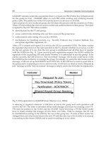
7. Motion control system design
To navigate along the topological map, we still have to define a suitable algorithm for the
position and orientation recognition in order to let the robot move on the true expected
path. This is mainly due to the inconsistency of the floor surface flatness level of where the
robot is navigating, that might cause to large error in robot displacement and orientation
after travelling for a certain distance.
In this work paper, we introduce a new method for mobile robot navigation, where the
robot recognizes its own orientation on every step of movement through NN, using the
same method for position recognition. In the proposed method, NN data for orientation
recognition is prepared separately with NN data for the position recognition. By separating
the NN into 2 functions, the width of the domain area for position recognition can be
organized without giving influence to the orientation recognition. Furthermore, it is
believed that through this, extensively efficient orientation recognition is achievable.
As mentioned earlier in is paper, in the proposed approach the robot need to conduct a
recording run first to capture images for instructor data collection. The robot will be brought
Vision-only Motion Controller for Omni-directional Mobile Robot Navigation
41
to the environment where it will have to navigate. At each selected node, the robot will
allow to capture images to prepare instructor data and NN data for both position and
orientation recognition. Topological map of the environment is prepared as soon as the
recording run is completed.
Next, when the robot performs autonomous run in the environment, visual features
extracted from the captured image is fed through the NN for position recognition first. This
recognition operation will be based on the NN data prepared for the position recognition. If
the result shows that the robot is not arriving near the target node yet, the orientation
recognition process will be executed. The robot will apply the same visual features to each
NN data of 5 different directions of the target node. This process is illustrated in Fig. 9. The
robot will need to capture only 1 image at each movement which will help to improve the
robot navigation time.
Fig. 9. NN evaluation against NN data of the 5 different directions
From the results produced by the 5 NN data, the robot will be able to determine its current
progress direction by computing the median point of the results. An example of this
evaluation method is demonstrated by Fig. 10. After the current progress direction is
understood, the robot will calculate the difference in angle between target node and current
progress direction, and correct its direction towards the target node. The same procedure is
repeated until the robot able to recognize that it is within the domain of the target node and
stop. This exercise will help keeping the robot on the true expected path. Through this, the
robot will able to move on the path to the target destination. Fig. 11 presents an algorithm of
the robot movement from TNm (target node of m order) to TNn including the orientation
recognition process.
7.1 Positioning control
At every step of the robot movement, the robot will perform a self-localization task first in
order to determine whether it has reached the target node or not. In order to perform the
self-localization task, the robot can simply capture one image and feed the extracted visual
features into the NN. Based on our empirical studies, we found out that the NN output is
gradually increasing when the robot is approaching towards the target node.
The work in this research study does not put aim on letting the robot to perform a precise
localization task. Therefore, when preparing the instructor data for NN of each node, a fact
that the robot will be able to localize itself within a certain area around each node, rather
than the exact centre of the node, need to be considered. This is necessary to ensure that the
robot will not stop rather far from the centre of the node. Thus it will help the robot to avoid
such problems like turning earlier than expected at a corner place which might cause a crash
to the wall.
Advances in Robot Navigation
42
Fig. 10. Evaluation method for current progress direction
Fig. 11. Navigation algorithm consists of robot movement from a TNm to TNn
To be able to get a sufficiently robust localization output, the robot is arranged to capture 3
images around the centre of each corresponding nodes. 1 image is captured at the centre of
the node and the other 2 images are about 5mm to the left and right from the centre, as
shown in Fig. 12 (a). We believe that the domain area of the node which help the robot to
robustly identify the node, will be constructed in this way.
It is important to evaluate the ability of the robot on recognizing its own position
(localization) at around the specified nodes, before the robot is put to navigate in the real
environment. Tests were conducted at 3 places (nodes) in a corridor environment to see how
a domain of area for localization exists. The robot is moved manually every 5 cm between -
80 and 80 cm on the X, Y, Zr and Zl axis of the place midpoint as shown in Fig. 12 (b). The
robot is also rotated by 5 degree in an angle range between -60 and 60 degree as depicted in
Fig. 12 (c). The result is presented in Fig. 13.
Orientation Reco
g
nition
Vision-only Motion Controller for Omni-directional Mobile Robot Navigation
43
Fig. 12. (a) Positions where the image of instructor data is captured. (b)(c) Robot moves
along each X, Y Zr, Zl and R axis of the place midpoint to evaluate the domain around the
place
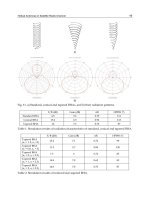
Fig. 13. Domain area acquired at the 3 places; (a) Place 1, (b) Place 2, (c) Place 3
7.2 Localization assessment
A manual localization experiment was performed in order to see the ability of the robot to
recognize its own position and thus localize the selected nodes. The experiment took place
at the 3
rd
floor corridor environment of the Mechanical Engineering Department building in
our university (Fig. 14). In this experiment, the localization is carried out against all the 3
nodes.
Fig. 14. Experiment layout of the corridor environment with the selected 3 nodes
Advances in Robot Navigation
44
After the instructor data is fed into NN for NN data preparation, the robot was brought
back to the corridor and manually moved to capture image at every 15mm from a starting
position which is about 150cm away from the Node 1 (see Fig. 14) until the last position
which is about 150cm ahead of Node 3. All the captured images are tested against NN data
of each 3 nodes.
The result of the localization experiment is shown in Fig. 15 (the graph with blue color). A
localization is considered achieved when NN output is higher than 0.7 (red line in the result
graph).
Fig. 15. Result of the test images localization test against NN data of each node; (a) Output
from Node 1 NN, (b) Output from Node 2 NN, (c) Output from Node 3 NN
There are some errors occurred in the result against NN data of Node 2, where images
around distance of 1200~1800cm mistakenly responded to the NN of Node 2 (Fig. 15 (b)).
The same phenomenon can be seen at the distance of about 3000~3600cm from the starting
point.
The set of instructor data described in previous section does not result in any particular
width, depth, and shape of the domain area for position recognition. Even though we do not
Vision-only Motion Controller for Omni-directional Mobile Robot Navigation
45
aim at the exact center of the node, it is desirable to have a way to somewhat control the size
and shape of the domain area so that it is more compact and the robot will be able to
converge and stop as much nearer as possible to the center of the node. In fact, the
unnecessary mis-recognitions as occurred in the localization result against NN data of Node
2 (Fig. 15 (b)), should be prevented. The idea is to add few instructor data to the current
method of preparation, which is believed will reduce the NN output just outside the desired
area.
After some preliminary tests, result of the tests indicated that if 2 instructor data of images
taken at distanced points of front and back from the center of the node, is added, and
trained the NN to output 0.1 for them, the localization domain of the node will be less
smaller (Fig. 16). However, distance of the additional data is different for each node to
obtain the best domain area for localization. It should be at 90cm for Node 1, 100cm for
Node 2 and 30 cm for Node 3. Localization results against NN data of the new method of
instructor data is shown in purple graph of Fig. 15.
Fig. 16. New method of acquiring instructor data; additional data whose output is set to 0.1
assigned at distanced points of front and back from the centre of the node
As a conclusion to this result, the width, depth and shape of the domain area might be
suffering by influences from the environment condition. A different method for preparing
the instructor data (with unfixed distance of additional data which trained to output 0.1)
might be necessary for different nodes even in the same environment. The shape and the
width of the domain area are not identical on every places. They vary and depend much on
the environment condition. For example when setting a place at a corner in the corridor, it is
necessary to put a consideration on the width of the domain area in order to avoid a
problem where the robot turns earlier and crashes into the wall. Furthermore, to let a robot
navigate in a narrow environment, it may be necessary to provide a smaller domain area of
each place.
Advances in Robot Navigation
46
7.3 Orientation control
When the robot is navigating through the environment, it is important for the robot to know
its own moving direction in order to move on the true expected path. By knowing its own
moving direction, the robot will be able to correct the direction towards the target
destination.
In the approach which is proposed in this research study, visual features from the image
captured at each step of the robot movement will be fed into the 5 NN data of different
directions of the target destination (node). The visual features are the same features used for
the position recognition. From the output results of the 5 NNs, the robot will be able to
determine its current moving direction.
To prepare the instructor data and NN data for the orientation recognition, the robot is
arranged to capture 5 images as shown in Fig. 17; 1 image at the centre and 1 image each to
forward and backward from the centre along the x and y axis. For each node, the instructor
data images are captured on 5 different directions during the recording run phase, as
depicted in Fig. 18. A set of instructor data, which consist of visual features extracted from
the images is prepared for each direction. The instructor data comprises 5 sets of features
data of the direction whose output is set to 1, and 1 set of features data from each other
directions whose output is set to 0. The instructor data are then going through a learning
process in the NN to obtain NN data. 5 sets of NN data in total are prepared for each node
in an environment.
Target Node Other
(Direction 0
o
) Direction
Fig. 17. Positions where images for instructor data are captured for orientation recognition
Fig. 18. Preparing the instructor data for orientation recognition of 5 different directions
Vision-only Motion Controller for Omni-directional Mobile Robot Navigation
47
Fig. 19. Results of recognition capability against NN for orientation recognition in which
distance for images captured at x axis is fixed
Advances in Robot Navigation
48
In order to recognize the finest distance for the 4 images on the x and y axis, a series of tests
have been conducted at the Node 3 of the corridor environment (see Fig. 14). The test has
been divided into two stages where in the first stage, 2 images of x axis are fixed to the
distance of 30mm from the centre. As for the y axis, the 2 images are captured on every
10mm between distances of 30mm to 100mm, which means 8 sets of instructor data are
prepared. After the instructor data is fed into NN for NN data preparation, a set of test
images have been captured at every 15mm from a starting position which is about 4650cm
far from the node. The output results of the test images which are tested against each NN
data are shown in Fig. 19.
The results show that NN data which consists of instructor data images captured at 80mm
from the centre of the node on the y axis produced the best recognition result. The test
images output is mostly constant above 0.7 from a distance of about 4000cm, with few
failure recognitions happened. With this condition, it is believed that mobile robot will be
able to determine the current progress direction from as far as 40m from the centre of the
node.
Next, in the second stage of the test, the 2 images on the y axis have been fixed to the
distance of 80mm from the centre of the node. This is appropriate to the result of the first
stage test. Images have been captured at 4 distances of 5mm, 10mm, 15mm and 30mm on x
axis. 4 sets of instructor data and NN data are prepared. Using the same set of test images
from the first stage test, a series of tests have been conducted against the 3 sets of NN data.
The results which presented in Fig. 20 show that NN data with instructor data images
captured at the distance of 30mm produced the finest result.
Fig. 20. Results of recognition capability against NN for orientation recognition in which
distance for images captured at y axis is fixed