GIS and Evidence-Based Policy Making - Chapter 13 pdf
Bạn đang xem bản rút gọn của tài liệu. Xem và tải ngay bản đầy đủ của tài liệu tại đây (1.23 MB, 14 trang )
13
A GIS-Based Methodology to Support the
Development of Local Recycling Strategies
Andrew Lovett, Julian Parfitt, and Gilla Su
¨
nnenberg
CONTENTS
13.1 Introduction 299
13.2 Research Methodology 300
13.3 Results 306
13.4 Conclusions 309
Acknowledgments 310
References 310
13.1 Introduction
Following the publication of the Waste Strategy 2000 and its associated
performance targets (DETR and National Assembly for Wales, 2000), there
is presently particular interest among local authorities in improving their
household waste recycling rates. The governmen t has set a national house-
hold waste and composting target of 25% by 2005–2006, to be met through
the cumulative effect of individual statutory targets for each local authority
(Cabinet Office Strategy Unit, 2002). Many authorities have introduced
kerbside collections of recyclables or established facilities at Civic Amenity
(CA) sites, smaller neighborhood recycling centers, or supermarkets where
households can deposit materials such as glass, paper, or cans. The form
and extent of such recycling infrastructure provision varies greatly between
local authorities (Parfitt et al., 2001; Community Recycling Network, 2002),
and it is not straightforward to assess the effectiveness of different initia-
tives. Partly this is because recycling rates also tend to differ according to
the socioeconomic characteristics of the population involved (e.g., Tucker
et al., 1998; Perrin and Barton, 2001; Barr, 2002; EnCams, 2002), but there are
additional difficulties arising from the need to examine the interaction
between the recycling scheme and use of other household waste stream
ß 2007 by Taylor & Francis Group, LLC.
outle ts such as conven tional house-to -house refus e vehicl e collectio ns.
A further comp lication is that opera tional weight data often relates to a
diver sity of zon es (includ ing collectio n rou nds or catchmen t areas of differ-
ent sizes around ‘‘b ring’’ sites) , so making the task of reco nstructi ng the
hou sehold waste stream and linkin g suc h informati on to define d popu la-
tion s a challe nging one.
Ge ographical informati on system s (GIS) can mak e a sign ificant contri bu-
tion to the problem s of evaluat ing recycl ing strat egies because of their
abili ty to integrat e data from opera tional entitie s such as CA sites or refuse
colle ction rounds with details of the popu lation residen t in par ticular loca-
tion s (Lovett, 2000). This capaci ty to link da ta sour ces ba sed on geogr aphi cal
posi tion, co upled with the me ans to calcul ate ad ditional inform ation such as
acces sibility me asures or catch ment boun darie s, in turn permits the recon-
struct ion of waste st ream charact erist ics at the local scal e. To illustrat e the
poten tial for enhanci ng waste man agem ent and plan ning through the use of
GIS , a res earch project was carr ied out in one local aut hority (South Norf olk
Cou ncil) to link subdistr ict opera tiona l da ta (from both collecti on round and
site- based sour ces ) with pop ulation det ails. This database was then used to
pre dict the impa ct of sever al poss ible new schemes for impro ving recycl ing
per formance and assess the extent to whic h they wou ld help the aut hority
meet thei r recycli ng targe ts for 2005–200 6.
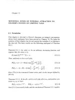
1 3.2 Rese arc h Meth od olog y
Sou th Norfo lk Cou ncil covers a predom inantly rural a rea of 908 km
2
extend-
ing from the south ern subur bs of Norwi ch to the county borde r with Suff olk
(Fig ure 13.1). In the 2001 census , the res ident popul ation was recorded
at 110,710, an increas e of som e 8% since 19 91 (Offic e for Nationa l Stat istics,
2003). When the resea rch began in 1999, the distri ct used black plastic
sack s for refus e colle ctions and had no ker bside recycl ing scheme s but
a high densit y of bring sites through the pro vision of a netw ork of minirecy-
clin g center s and facil ities at CA sites or local supermarke ts. South Norf olk
was chosen as a focus for the stu dy on several grounds that incl uded
the pre sence of a consi stent and wel l-maintai ned waste statisti cs database
(Parfitt, 1997), previous involvement in other GIS projects (e.g., Lovett et al.,
2003a), and proximity to the research team based in Norwich.
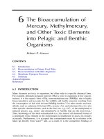
The three main pha ses of the resea rch are sum marized in Figure 13.2. In
the first phase, a GIS database was compiled that included details of recyc-
ling facility locations (Figure 13.1) and a road network with attributes such
as speed estimates to allow the calculation of car travel times (e.g., Lovett
et al., 2004). Boundaries of refuse collections were defined by generating
Thiessen polygons around addresses in the street listings used by contract-
ors, and then dissolving the dividing lines between areas served on
the same round day. Overall, there were 40 round days in the district
ß 2007 by Taylor & Francis Group, LLC.
Norwich
Wymondham
Bungay
Diss
South Norfolk minirecycling centers
Urban areas
0 5 10 15 20 25 km
A Roads
B Roads
Minor roads
South Norfolk district
Supermarket recycling centers
Civic amenity sites
Merchant recycling centers
FIGURE 13.1
Recycling facilities in South Norfolk, spring 2000. (ß Crown copyright=database right 2007. An
Ordnance Survey=EDINA supplied service.)
Phase 1: Desktop
Phase 2: Fieldwork
Phase 3: Refinement and
scenarios
Data preparation
•
•
•
•
•
•
•
Area classification of waste
variation (Cluster analysis)
Evaluation of recycling scenarios
Household
data: model
refined
Subdistrict
waste
variations
defined and
mapped
Compost bin assessments
600 house-to-house
interviews across different
round types focusing on
recycling activity and use
of facilities
Final GIS
Inititial GIS: combining waste
statistics and population
characteristics
FIGURE 13.2
The overall research methodology.
ß 2007 by Taylor & Francis Group, LLC.
(eight rounds each weekday), but only 13 of these (32.5%) represented a
single contiguous polygon and there were many irregularly shape d bound-
aries. Figure 13.3 illustrates a typical situation using the example of Round 5
in the southeast of the district. Operational factors (particularly vehicle
capacities) were the main reason for the complex configuration of round
days. For instance, some villages were served when a vehicle was traveling
to=from a landfill site, while in other cases full loads were generated by
collecting from part of a town followed by a section of the surrounding
rural hinterland.
Given the nature of the round-day boundari es it was difficult to reliably
estimate the populations of these areas from even the finest resolution
census statistics (i.e., enumeration districts) and there was also the problem
that the most recent details (from 1991) were somewhat outdated. As an
Loddon
Beccles
Bungay
Monday
Tuesday
South Norfolk district
Other rounds
Round 5
0 5 10 15 20 25 km
Norwich
Beccles
Bungay
Thursday
Friday
A roadsWednesday
FIGURE 13.3
Boundaries of daily refuse collection areas in Round 5. (ß Crown Copyright=database right
2007. An Ordnance Survey=EDINA supplied service.)
ß 2007 by Taylor & Francis Group, LLC.
alternative source, South Norfolk Council provided data from their Council
Tax register as of August 1999. The Council Tax is a compulsory local
taxation system based on residential property values and the register
is updated annually for each local authority (Eastham, 1993). Several
studies have identified associations between the propensity of households
to participate in recycling activities and the Council Tax valuations of their
properties (Mansell, 2001; Lovett et al., 2003b).
There were 47,474 properties on the South Norfolk register, of which
47,291 (99.6%) had useable postcodes. By applying geocoding and point-
in-polygon techniques to the data (household totals by unit postcode and
Council Tax band) it was straightforward to estimate the numbers of house-
holds in each round day, while the proportion of properties in different
valuation bands also provided a simple measure of socioeconomic status.
Figure 13.4 maps the percentage of households in bands A and B (the lowest
value properties) for each round day and indicates a general pattern of more
affluent areas around the southern fringe of Norwich.
Details of the refuse wei ghts (in metric tons) collected from each round-
day during the period March 1999–February 2000 were supplied by
South Norfolk Council. Other data on the weights of materials collected at
Norwich
Bungay
Harleston
Diss
10.0–24.99
Incomplete data
2.50 5 7.5 10 12.5 km
50.0–75.00
40.0–49.99
25.0–39.99
Wymondham
Beccles
FIGURE 13.4
Percentage of households in Council Tax bands A and B. (ß Crown Copyright=database right
2007. An Ordnance Survey=EDINA supplied service.)
ß 2007 by Taylor & Francis Group, LLC.
diffe rent types of bri ng faciliti es (e.g., mi nirecyc ling centers or CA sites)
were obtain ed from the re levant authorities . Thi s incl uded in formatio n from
sites outsi de the district that were kno wn to be used by South Norf olk
residen ts. All these sets of opera tional re cords encompas sed at least a
12-m onth per iod which helped to take account of kno wn season al variati ons
in co llection weig hts and so pro vide a more rep resentat ive pict ure of overall
trends. An areal interpol ation method was then used to appor tion the site
wei ght da ta among refuse co llection round da ys. This in volved first defin-
ing sets of catch ment area s (bas ed on shortest travel time) for eac h typ e of
bring site. Figure 13.5 shows an isochrone (travel time) map for CA sites and
Figure 13.6 the resu lting catchmen t boun darie s. The travel -time map high-
lights the influence of main roads (such as the A11, A140, and A146)
radiating out of Norwich, while the catchment areas indicate that in several
parts of South Norfolk (actually encompassing over 35% of residents), the
nearest CA site was outside the district.
Overlay techniques were employed to calculate the numbers of house-
holds in each refuse collection round that fell within differen t bring-site
catchments. Separate analyses were carried out for minirecycling centers
and CA sites. From the resulting allocation tables it was straightforward to
Estimated time in minutes
<5
Sites
Main roads
0 2.5 5 7.5 10
12.5
km
>25
20–25
15–20
10–15
5–10
FIGURE 13.5
Estimated travel time by car to nearest CA site. (ß Crown Copyright=database right 2007. An
Ordnance Survey=EDINA supplied service.)
ß 2007 by Taylor & Francis Group, LLC.
distribute the site weight data among collection rounds on the basis of
household numbers and so reconstruct the average weekly elements of the
domestic waste stream on a local area level.
Statistical analyses were conducted to examine associations between
socioeconomic variables (e.g., percentage of households in Council Tax
bands A and B) and the relative use of different outlets for household
waste across the 40 round days. A hierarchical cluster analysis was then
performed which divided the round days into five distinct clusters using
three classificatory variables based on the proportion of total household
waste arising from (1) refuse collection rounds, (2) CA sites, and (3) mini-
recycling centers.
In the second phase of the research, the classification results were used to
select a sample of six round days, and a door-to-door questionnaire survey
was conducted with over 100 hou seholds in each area. Each of the five
round-day clusters was represented in the sample. and a total of 615 ques-
tionnaire responses were obtained in August and September 1999. The
questionnaire survey elicited information on householders’ attitudes
toward recycling activities and their use of local waste management facil-
ities. In addition, an assessment of home composting activity was conducted
in which bins or heaps found at 200 of the sampled households were
examined, and the basic relationships betwe en garden characteristics and
composting activity were investigated. Findings from this research are
described elsewhere (Wheeler and Parfitt, 2002).
Berg Apton Snetterton
CA site
0 2.5 5 7.5 10 12.5 km
Main roads
Eye/Brome
Norwich
Beccles
Wymondham
Morningthorpe
Ketteringham
FIGURE 13.6
Predicted catchment areas (based on shortest travel time) of CA sites. (ß Crown Copy-
right=database right 2007. An Ordnance Survey=EDINA supplied service.)
ß 2007 by Taylor & Francis Group, LLC.
The final phase of the pr oject used the datab ase generated by the local
reco nstructio n of the hou sehold waste stream to exami ne the extent to
wh ich recy cling perform ance in South No rfolk could be impro ved by esta b-
lishin g new bring sites or introdu cing kerbside- collectio n scheme s for
dry recyclabl es or green waste in part or all of the district. Thi s sce nario
work require d a number of assum ptions about level s of partici pation in
kerb side collections and the mater ial co mposition of the hou sehold waste
stream. The former were based on da ta from a DETR sur vey of local
autho rity recycli ng perform ance (Parf itt et al., 2001), wh ile the latte r used
resu lts from resea rch condu cted for Project Integra in Ham pshi re (see
http: == ww w.integr a.org.uk = about =res earch) and the Environ ment Agenc y
(Parf itt et a l., 1999; Parfitt, 2000). Predic tions from the sc enario work were
subse quently compared agains t the statuto ry recycling targets for Sou th
Norf olk as sho wn in Ta ble 13.1 .
13.3 Results
Consi derable variabil ity was found in the average weights of refuse co l-
lect ed fo r in dividual round da ys. Figure 13.7 maps the average kilogram per
hou sehold per week weights (herea fter kg=hh =wk) for the year March 1999–
Febr uary 2000 and sho ws a rather mixe d pattern with, for examp le, no
sim ple tendenc y for val ues to be higher in mo re urbanized nei ghborh oods.
Equa lly, correl ations with the percenta ge of hou seholds in particul ar Coun-
cil Ta x bands were relative ly weak. These resu lts may we ll reflect the
comp lex bounda ries and diver se socioecono mic comp osition of some
rou nd days (see Section 13 .2). However , clear er trends were appare nt in
the use of bri ng sites, especial ly when the round days were grou ped into
the five clusters rather than analyze d individually. For instance, greater
TABLE 13.1
South Norfolk Recycling Performance
and Future Targets
Year
Household Waste
Recycling Rate
1998–1999 (base year) 10%
1999–2000 11%
2003–2004 20%
2005–2006 30%
Source: From the Department for Environment, Food
and Rural Affairs, in A Consultation Document on the
Distribution of the £140 Million Waste Minimisation and
Recycling Fund in England, DEFRA, London, 2001
(Annexe B).
ß 2007 by Taylor & Francis Group, LLC.
quantiti es of waste were taken to CA sites by re sidents in the northe rn half
of the district where average travel times to suc h facili ties were low est.
By contr ast, househo lders res ident in the most southe rly cluster of rou nd
days (Diss, Harleston , and Long Stratton ) had the lowest level s of accessi -
bility to CA facili ties and the highest me an quantitie s of refuse collectio n
round waste. Results from the questi onnaire sur vey indicated that man y of
these residen ts were driving at least 15 mi n to thei r nearest CA site, whic h
conf irmed the results of the GIS-based calcul ations sho wn in Figure 13.5.
There was also a good level of agree ment bet ween the GIS-predi cted site
catchme nts (e.g., Figure 13.6) and the facilities that questio nnaire respon d-
ents rep orted using. The main dif ference betwe en actual and pred icted
behavi ors was that some res pondents used sites on the way to (or from )
Norwi ch or other large r town s rather than thos e that they resided neares t.
Neverth eless, the extent of such discrep ancies was suffici ently small to
provide confiden ce in the procedur e used to allocate the bring site da ta
to round days .
Figure 13.8 summarizes the results of the waste stream reconstruction exer-
cise for the five clusters of round days. The boundaries on this map are those
of the 40 refuse collection round days grouped into the clusters, whereas the
grayscale shading depicts the average total recycling rate each week. For each
cluster there is also a proportional symbol whose size represents the total
Norwich
Bungay
Harleston
Diss
Wymondham
Beccles
8.0–9.99
Incomplete data
2.50 5 7.5 10 12.5 km
15.0–17.00
12.5–14.99
10.0–12.49
FIGURE 13.7
Average refuse collection weights (kg=hh=wk) for round days, March 1999–February 2000.
(ß Crown Copyright=database right 2007. An Ordnance Survey=EDINA supplied service.)
ß 2007 by Taylor & Francis Group, LLC.
weight of waste per household each week and the subdivisions show the
proportions of the waste stream going to different outlets.
A feature of Figure 13.8 is that some of the clusters are quite geographic-
ally concentrated, even though there was no explicitly spatial factor in the
definition of groups. Such an outcome, however, can be attributed to
the contrasts in the accessibility and use of bring sites mentioned above.
The highest recycling rates were associated with round days where resi-
dents had both CA sites and minirecycling centers easily accessible, but
there was considerable variability in performance with the best areas
achieving over 30% and the lowest less than 15% (these figures include
estimates of materials taken to outside the district).
Analysis of the questionnaire responses showed that the amount of material
put out for the refuse collection increased with household size and declined
with involvement in recycling activities or composting. When asked what
would encourage them to recycle more, around 50% of respondents mentioned
the provision of kerbside collections, whereas another 20% suggested addi-
tional local bring sites. These options were investigated further in a series of
scenarios regarding additional recycling facilities. The results of this exercise
soon indicated that further bring-site provision was unlikely to be of major
Norwich
Bungay
Beccles
Harleston
Proportion of total kg/hh/wk
Green
waste
Collection
round
Residuals
at CA
Dry
recyclables
Diss
Cluster label
Diss/Harleston/Long Stratton
Incomplete data
6.3
3.3
Total recycling
kg/hh/wk
4.0
4.8
5.3
Rural with high CA and minirecycling
site use
Urban north
Rural with high minirecycling site use
Wymondham
FIGURE 13.8
Variations in waste generation and recycling activity by round-day cluster. (ß Crown Copy-
right=database right 2007. An Ordnance Survey=EDINA supplied service.)
ß 2007 by Taylor & Francis Group, LLC.
benefit in helping South Norfolk to meet its statutory targets and therefore
attention was focused on the impact of new kerbside schemes.
Figure 13.9 illustrates the predicted outcomes of a series of scenarios
concerning the introduction of new kerbside schemes. The GIS database
was used as part of this exercise to help determine where the introduction of
kerbside-collection schemes would have the greatest impact on recycling
performance. In addition, options for meeting the statutory targets with
multimaterial dry recyclables and green waste collections were considered.
The results suggested that introducing kerbside collections of dry recycl-
ables in Round 1 (around the edge of Norwich) and Round 3 (Wymondham
and surrounding villages) would certainly boost recycling rates, but that
coverage of more than these 10 round days would be required to meet the
2003–2004 target of 20%. Looking further ahead, the predictions indicated
that the 2005–2006 target of 30% might be achievable if the kerbside collec-
tion of dry recyclables occurred across South Norfolk (Scenario 6), but that
this would be dependent on achieving high participation rates. If this
condition was not achieved, then a district-wide kerbside collection of
green waste (Scenario 7) would be required to meet the 2005–2006 target.
13.4 Conclusions
The GIS-based methodology developed in this research provides a means of
integrating site and round weight data to develop a better understanding
of household recycling performance at a subdistrict level. Reconstructing
the household waste stream in this way also provides a valuable platform
for evaluating the likely impact of new recycling services. In the case of
South Norfolk, a trial kerbside-collection of dry recyclables was introduced
0
5
10
15
20
25
30
35
40
Recycling (%)
1234567
Scenarios
FIGURE 13.9
Predicted outcomes of introducing different kerbside schemes on district recycling rates. Key to
scenarios: (1) baseline, 1998=99; (2) dry recyclables kerbside, Round 1; (3) dry recyclables kerbside,
Round 3; (4) dry þ green waste kerbside, Round 1; (5) dry þ green waste kerbside, Round 3; (6)
dry recyclables kerbside, all rounds; and (7) dry þ green waste kerbside, all rounds.
ß 2007 by Taylor & Francis Group, LLC.
in the village s of Mulba rton and Bracon Ash in Sep tember 2003. This
scheme invo lves each househo ld havin g two wheele d bin s, wh ich for dry
recycl ables bein g collected 1 wk and the ot her for residual refuse the next .
A numbe r of other local aut horities have also ad opted such an alt ernate
wee k co llection syst em as a me ans of pr oviding a cost-effe ctive refuse and
recycl ing service to their residen ts (DEFR A, 2001, 2002).
The recycli ng rates achieve d by the kerbs ide trial in South Norf olk
have exce eded expectatio ns and a similar ser vice is now bein g gradu ally
rolled out to ot her par ts of the district. If the cu rrent level of par ticipation
is maint ained then South Norf olk shou ld ce rtainly meet its target for
2003–200 4 and will be well on the way to achieving that for 2005–200 6.
Howeve r, there is like ly to be a need to attain still higher level s of recycl ing
at both local and nationa l levels in the future (Cabine t Office Strateg y
Unit , 2002; Norf olk Waste Partnership , 2002). In these ci rcumstanc es,
the role of GIS in the planning and monitorin g of hou sehold waste man -
agem ent service s could be in valuable. At present, suc h a pplications are
rela tively rare in local aut horities and it is likel y to require improve ments
in sever al aspect s of data quality and storage before they bec ome mo re
commo n. Neve rtheless, resea rch such as that pres ented in this chapter
dem onstra tes the contr ibution that the use of GIS can mak e to the pro vision
of inform ation from which effective hous ehold waste mana gement policies
can be formulat ed.
Acknowledgments
This research was funded as an ENTR UST (Lan dfill Tax Credits Sche me)
pro ject thr ough UEAEA with supp ort from NEWS (Norfo lk Envi ronmen tal
Was te Servi ces) and South Norfolk Council. We wou ld like to thank the staff
of bot h org anizations for their help wh ile absolvin g them of any respons i-
bility for the opini ons expresse d.
References
Barr, S., 2002, Household Waste in Social Perspective: Values, Attitudes, Situation and
Behaviour (Aldershot: Ashgate).
Cabinet Office Strategy Unit, 2002, Waste Not, Want Not: A Strategy for Tackling the
Waste Problem in England (London: Cabinet Office).
Community Recycling Network, 2002, Maximising Recycling Rates—Tackling Residuals
(Bristol: Community Recycling Network) (http: ==www.crn.org.uk, accessed on
March 2003).
Department of the Environment, Transport and the Regions, and National Assembly
for Wales, 2000, Waste Strategy 2000 for England and Wales Parts 1 and 2 (London:
The Stationary Office).
ß 2007 by Taylor & Francis Group, LLC.
Department for Environment, Food and Rural Affairs, 2001, A Consultation Document
on the Distribution of the £140 Million Waste Minimisation and Recycling Fund in
England (London: Department for Environment, Food and Rural Affairs).
Department for Environment, Food and Rural Affairs, 2002, Municipal Waste Man-
agement Survey 2000=01 (London: Department for Environment, Food and Rural
Affairs).
Eastham, L.S., 1993, Council Tax (London: Citizen Advice Notes Service Trust).
EnCams, 2002, Waste Segmentation Research 2002 (Wigan: EnCams) (http: ==www.
encams.org, accessed on November 2002).
Lovett, A.A., 2000, GIS and environmental management. In Environmental Science
for Environmental Management , Second Edition, edited by O’Riordan, T.,
pp. 267–285 (Harlow: Prentice-Hall).
Lovett, A.A., Su
¨
nnenberg, G., and Haynes, R.M., 2003a, Accessibility to GP surgeries
in South Norfolk: a GIS-based assessment of the changing situation 1997–2000.
In Socio-Economic Applications of Geographic Information Science: Innovations in GIS
9, edited by Kidner, D., Higgs, G., and White, S., pp. 181–198 (London: Taylor &
Francis).
Lovett, A.A., Parfitt, J.P., Hummel, J., Bone, A., Su
¨
nnenberg, G., and Pearce, S., 2003b,
Research for Monitoring and Evaluation of the Peterborough Recycling Cell (Norwich:
School of Environmental Sciences, University of East Anglia).
Lovett, A.A., Su
¨
nnenberg, G., and Haynes, R.M., 2004, Using GIS to assess accessibility
to primary health care services. In GIS in Public Health Practice: Opportunities and
Pitfalls, edited by Maheswaran, R. and Craglia, M. (London: Taylor & Francis).
Mansell, D., 2001, Bristol Recycling Participation Study (Bristol: The Recycling
Consortium).
Norfolk Waste Partnership, 2002, Municipal Waste Strategy for Norfolk , 1st Revision
(Norwich: Norfolk Waste Partnership).
Office for National Statistics, 2003, Census 2001: Key Statistics for Local Authorities in
England and Wales (London: The Stationary Office).
Parfitt, J.P., 1997, An Assessment of the Quality of Household Waste Statistics in Norfolk .
Report to the Norfolk Waste Management Partnership (Norwich: School of
Environmental Sciences, University of East Anglia).
Parfitt, J.P., 2000, A Study of the Composition of Collected Household Waste in the UK: with
Particular Reference to Packaging Waste, Technical Report P347 (Bristol: Environ-
ment Agency).
Parfitt, J.P., Flowerdew, R., and Pocock, R., 1999, A Review of the United Kingdom
Household Waste Arisings and Compositional Data, Final report prepared under
contract No. EPG 7=10=21 CLO 0201 for the Wastes Technical Division, Depart-
ment of the Environment (Bristol: Environment Agency).
Parfitt, J.P., Lovett, A.A., and Su
¨
nnenberg, G., 2001, A classification of local authority
waste collection and recycling strategies in England and Wales. Resources, Con-
servation and Recycling 32, 239–257.
Perrin, D. and Barton, J., 2001, Issues associated with transforming household atti-
tudes and opinions into materials recovery: a review of two kerbside recycling
schemes. Resources, Conservation and Recycling 33, 61–74.
Tucker, P., Murney, G., and Lamont, J., 1998, Predicting recycling scheme perform-
ance: a process simulation approach. Journal of Environmental Management 53,
31–48.
Wheeler, P. and Parfitt, J.P., 2002, Life cycle assessment of home composting.
Proceedings of Waste 2002 Conference, Stratford.
ß 2007 by Taylor & Francis Group, LLC.
ß 2007 by Taylor & Francis Group, LLC.