Landscape of Brazil
Bạn đang xem bản rút gọn của tài liệu. Xem và tải ngay bản đầy đủ của tài liệu tại đây (318.08 KB, 4 trang )
Fragile Amazon Rain Forest
The Brazilian government has built roads into the Amazon rain forest, opening it to development for mining and agriculture.
But most forest topsoil is thin and infertile, and newly planted crops deplete soil nutrients within a few years. Mining
operations have contaminated soils with the mercury that is used to extract gold.
Loren McIntyre/Woodfin Camp and Associates, Inc.
Microsoft ® Encarta ® 2008. © 1993-2007 Microsoft Corporation. All rights reserved.
Brazil's Wet Guiana Highlands
The northwest-facing slopes of northern Brazil's Guiana Highlands capture clouds that release heavy downpours. The runoff
collects into many streams that join tributaries of the Amazon and Orinoco rivers. The region is sparsely populated and
undeveloped.
Dan Guravich/Photo Researchers, Inc.
Microsoft ® Encarta ® 2008. © 1993-2007 Microsoft Corporation. All rights reserved.
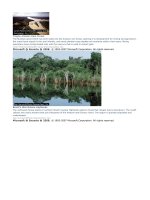
Forests of the Amazon Basin
More than half of Brazil lies in the heavily forested Amazon Basin. The tropical rain forest of the Amazon Basin is among the
world's most varied ecosystems, containing more than 2 million plant and animal species. In the space of 2.6 square
kilometers (1 square mile), biologists have identified more than 3,000 tree types, among them Brazil nut, mahogany,
purple heart, and rosewood. The great commercial value of these trees has drawn loggers to the Amazon Basin, raising
concerns about deforestation.
Ulrike Welsch/Photo Researchers, Inc.
Microsoft ® Encarta ® 2008. © 1993-2007 Microsoft Corporation. All rights reserved.
Waterfall in the Brazilian Highlands
The principal rivers of Rio Grande do Sul, the southernmost state of Brazil, drain into the Lagoa dos Patos near Porto Alegre.
In the highlands of the northeast corner of the state, the thick mountain forests are punctuated by dramatic cascades such
as this one, near Canela.
Francois Gohier/Photo Researchers, Inc.
Microsoft ® Encarta ® 2008. © 1993-2007 Microsoft Corporation. All rights reserved.
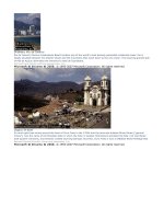
Rondônia, Brazil
These Landsat images show a portion of the state of Rondônia, Brazil, in which forest cutting has taken place during an 11-
year time span-from 19 June 1975 (left) to 1 August 1986 (right). Systematic cutting of the forest vegetation starts along
roads and then fans out to create the "feather" pattern shown in the right half of the 1 August 1986 image. The cutover
land and urban areas appear in light green and blue, whereas healthy vegetation is shown as red.
U.S. Geological Survey/© Microsoft Corporation. All Rights Reserved.
Microsoft ® Encarta ® 2008. © 1993-2007 Microsoft Corporation. All rights reserved.
Planaltos of Brazil
Stretched out in the interior of northeast Brazil are eroded mountains that have formed high planaltos, or plains. Rising
from these planaltos are isolated mountains, which are composed of rock that is more resistant to erosive forces such as
wind and precipitation.
Tyba/Claus Meyer/Latin Focus
Microsoft ® Encarta ® 2008. © 1993-2007 Microsoft Corporation. All rights reserved.
Fernando de Noronha Islands
Isolated 400 kilometers (250 miles) off Brazil's coast, the federal territory of Fernando de Noronha consists of an island
group that was once a penal colony for Portugal and, later, Brazil. A volcano created the largest island, also called Ilha
Fernando de Noronha. The territory's economy is based on guano and salt.
Peter Feibert/CONTEXTO
Microsoft ® Encarta ® 2008. © 1993-2007 Microsoft Corporation. All rights reserved.
Rio de Janeiro Carnival
Brazil’s annual Carnival festival attracts visitors from all over the world to Rio de Janeiro. The famous celebration, held
before the start of Lent, includes dance (notably samba competitions), song, and music. Spectacular costumes provide a
riot of color throughout the days of parties.
Stephanie Maze/National Geographic Society
Microsoft ® Encarta ® 2008. © 1993-2007 Microsoft Corporation. All rights reserved.