4 9 earth and water, high and low
Bạn đang xem bản rút gọn của tài liệu. Xem và tải ngay bản đầy đủ của tài liệu tại đây (3.78 MB, 10 trang )
Fascinating Facts
• American writer Mark Twain described
the shape of the Mississippi River as “a
long, pliant [easily bent] apple-paring
[peeling].”
• Each of the Great Lakes ranks among
the fourteen largest lakes in the world.
• Rain forests grow in parts of the West
near the Pacific coast.
Genre
Nonfiction
Comprehension Skill
Compare and
Contrast
Text Features
• Maps
• Captions
Earth and Water,
High and Low
by
Scott Foresman Social Studies
ISBN 0-328-14840-7
ì<(sk$m)=beiea < +^-Ä-U-Ä-U
ANN ROSSI
In this book you will learn about different
areas of the United States. You will also
read about some of the natural features
that are found in those areas.
Write to It!
Which waterway or landform would
you most like to see? Write a paragraph
explaining your choice. Include at least
three reasons for your choice.
Vocabulary
region
Write your paragraph on a separate sheet
of paper.
plain
landform
desert
mountain
Earth and Water,
High and Low
erosion
volcano
by
wetland
prairie
waterway
glacier
ANN ROSSI
Maps
MapQuest, Inc.
Photographs
Every effort has been made to secure permission and provide appropriate credit for photographic material. The publisher deeply
regrets any omission and pledges to correct errors called to its attention in subsequent editions.
Unless otherwise acknowledged, all photographs are the property of Scott Foresman, a division of Pearson Education.
Photo locators denoted as follows: Top (T), Center (C), Bottom (B), Left (L), Right (R), Background (Bkgd)
ISBN: 0-328-14840-7
Copyright © Pearson Education, Inc.
All Rights Reserved. Printed in the United States of America. This publication is protected
by Copyright, and permission should be obtained from the publisher prior to any prohibited
reproduction, storage in a retrieval system, or transmission in any form by any means,
electronic, mechanical, photocopying, recording, or likewise. For information regarding
permission(s), write to: Permissions Department, Scott Foresman, 1900 East Lake Avenue,
Glenview, Illinois 60025.
1 2 3 4 5 6 7 8 9 10 V0G1 14 13 12 11 10 09 08 07 06 05
Opener: ©Transparencies, Inc.
2 ©David Edwards/NGS Image Collection
4 ©David Muench/Corbis
5 ©Corbis
6 ©DK Images
7 ©Transparencies, Inc.
8 ©Steve Dunwell/Index Stock Imagery
9 ©Jake Rajs/Getty Images
Editorial Offices: Glenview, Illinois • Parsippany, New Jersey • New York, New York
10 ©Digital Vision
11 ©Iain Davidson Photographic/Alamy
Sales Offices: Needham, Massachusetts • Duluth, Georgia • Glenview, Illinois
13 ©NASA/Corbis
Coppell, Texas • Sacramento, California • Mesa, Arizona
14 ©Getty Images
15 ©Scott Smith/Index Stock Imagery
Regions of the United States
Areas in the United States
CA
CANADA
PACIFIC OCEAN
HI
0
100 Miles
0 100 Kilometers
CO
Colo
R. ra
COLORADO
PLATEAU
do
AZ
NM
NE
PA
IA
IL
KS
MO
OK
Re d R .
AR
TX
IN
Oh
i
0
0
N
MEXICO
200
DC
VA
NC
P
AP
SC
GA
L
AL
AT
TN
MS
OH
R . WV
KY
LA
PACIFIC
OCEAN
HI
AN
TI C
MO
PL C
UN
A I OA
TA
N
ST A
INS
L
CA
NS
Northeast
Southeast
Midwest
Southwest
West
UT
TAI
NV
ME
MA
NY
MI
WI
SD
WY
AC
UN
Key
MN
RI
CT
NJ
DE
MD
AN
ID
MO
400 Kilometers
PACIFIC OCEAN
.
Y
OR
MT M issouri R ND
o
400 Miles
AL
CK
0
NH
VT
RO
0
WA
R.
D
A
M ississip
pi
AK
NA
People sometimes talk about different areas in the
United States. They divide the United States into these
regions: Northeast, Southeast, Midwest, Southwest,
and West.
The natural features in each region make it special.
For example, plains are a landform in the Midwest.
A desert is a landform in the Southwest.
FL
ATLANTIC
OCEAN
Gulf of
Mexico
400 Miles
200 400 Kilometers
This map shows the five regions of the United States.
Many kinds of rivers and landforms are found in more
than one region. For example, rivers are found in all
regions. Almost every region has a mountain range.
You will read about some of the landforms in the
United States.
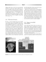
You can see rock formations like this one in the Southwest.
2
3
Mountains
Mountains are usually steep and have sharp or rounded
peaks. Forces within Earth form mountains. Erosion
caused by wind and rain shape them.
The Rocky Mountains are in the West. They are the
largest mountain system in North America. The highest
peaks in the Rocky Mountains are in Colorado. Many
peaks are more than 14,000 feet (4,267 meters) high.
Mount St. Helens is located in Washington.
Mount Elbert is the tallest peak in the Rocky Mountains.
The Cascade Range is another mountain range in
the West. Most of the peaks in the Cascade Range are
volcanoes. Mount St. Helens is a volcano in the Cascade
Range. For more than 120 years, Mount St. Helens was
quiet. Then, in 1980, it erupted. In October 2004,
Mount St. Helens erupted again.
5
Inside a Volcano
Ash cloud
Lava
Feeder pipe
Magma chamber
A volcano may erupt when magma, or melted
rock, gathers underground in a magma chamber.
Pressure from within Earth forces the magma up.
The volcano then erupts lava and clouds of steam,
ash, and gases. Lava is the term for magma that
erupts onto Earth’s surface.
6
The Appalachian Mountains are the oldest mountain
system in North America. They are part of a large
mountain system. The Appalachians are in the eastern
part of the United States.
Several mountain ranges in the Northeast and the
Southeast make up the Appalachian Mountains. The tallest
peak of the Appalachians is Mount Mitchell. It is 6,684
feet high (2,037 meters).
Mount Mitchell is located in the Black Mountains.
7
The Gulf Coastal Plain curves along the Gulf of
Mexico. Both the Gulf Coastal Plain and the Atlantic
Coastal Plain have many kinds of wetlands. Swamps
and marshes are wetlands. Rivers flow from inland areas
through the coastal plains to the ocean.
A prairie is a fairly flat plain covered mainly by tall
grasses. Prairies stretch across the Midwest from Canada
to Texas. Different types of grasses grow in the rich prairie
soil.
This part of the Great Plains is located in the Midwest.
This part of the Atlantic Coastal Plain is in
the Northeast.
Plains and Prairies
A plain is a large area of fairly flat land. Plains are
found in many regions of the United States. The Atlantic
Coastal Plain lies along the East Coast.
8
Rivers and Lakes
The Mississippi River is the largest river in North
America. It is an important waterway. The Mississippi
River begins in Minnesota and flows south to the Gulf of
Mexico.
The Rio Grande and the Colorado River both begin
in the West, in Colorado. They are also important to the
Southwest. The Rio Grande forms the border between
Texas and Mexico. The Colorado River forms the border
between Arizona and California. Both rivers are used to
bring water to the dry Southwest. The Colorado River is
also an important source of water for southern California.
The Mississippi River is a busy waterway.
The Rio Grande flows through New Mexico.
11
The Great Lakes
250 Miles
n
125
0
e Superior
Lak
125
250 Kilometers
CANADA
S
MN
aw
re
nc
e
To
Atl Rive
an
ti
r
c
ea
0
Oc
ME
L
t.
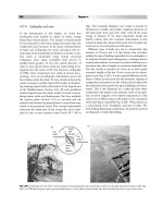
The Finger Lakes are much smaller than the Great Lakes.
The Finger Lakes are not linked. Long ago the Finger Lakes
were rivers. They are located in the Northeast.
VT
WI
Lake Michiga
n
Lake
Huron
nt
eO
Lak
MI
NH
ario
NY
CT
Lak
e
Er
Illi
n
Riv ois
er
pp
issi
iss
M
MO
NJ
OH
IN
N
MD
IL
DE
Key
ATLANTIC
OCEAN
WV
National border
State border
VA
i
Ri
RI
ie
PA
IA
MA
ve
KY
r
River
The Great Lakes, rivers, and canals combine to form
a network of waterways.
Lakes are also important waterways. The Great Lakes
are a chain of five lakes in the northern United States.
Sheets of moving ice called glaciers created these lakes
long ago. The Great Lakes are part of a major waterway
that connects the Midwest with other areas.
12
The Finger Lakes in New York State, as seen from above, look
like fingers on a hand.
Deserts, volcanoes, rivers, lakes, mountains, plains,
islands, and wetlands—all these landforms and
waterways are in the different regions of the United
States. From the mountains to the coastal plains, they are
what shape the United States.
The Atlantic Coastal Plain is located on the East Coast.
The Mojave Desert is part of the North American Desert.
Deserts and Other Places
In the United States, deserts are found in the West and
Southwest. The Mojave (moe-HA-vee) Desert is part of a
larger desert area called the North American Desert. The
dry Mojave gets only a few inches of rain each year.
14
In this book you will learn about different
Glossary
Write to It!
areas of the United States. You will also
desert an area that gets very little rain
read about some of the natural features
erosion
rock by water
thatthe
arewearing
found inaway
thoseofareas.
and wind
Which waterway or landform would
you most like to see? Write a paragraph
explaining your choice. Include at least
three reasons for your choice.
glacier huge sheets of ice that cover land
Vocabulary
landform a natural feature
of the earth’s surface
region
Write your paragraph on a separate sheet
of paper.
mountain a very high landform,
often with
plain
steep sides
landform
plain an area of flat land that often is covered
desert
with grass or trees
prairie an area wheremountain
grasses grow well, but trees
are rare
erosion
region an area in which
places share similar
volcano
characteristics
wetland
volcano a mountain with
an opening through
prairie
which ash, gas, and lava are forced
waterway
waterway a system of rivers, lakes, and canals
glacier
through which ships travel
wetland land that is covered with water at times
ISBN: 0-328-14840-7
Copyright © Pearson Education, Inc.
All Rights Reserved. Printed in the United States of America. This publication is protected
by Copyright, and permission should be obtained from the publisher prior to any prohibited
reproduction, storage in a retrieval system, or transmission in any form by any means,
electronic, mechanical, photocopying, recording, or likewise. For information regarding
permission(s), write to: Permissions Department, Scott Foresman, 1900 East Lake Avenue,
Glenview, Illinois 60025.
1 2 3 4 5 6 7 8 9 10 V0G1 14 13 12 11 10 09 08 07 06 05
16
Maps
MapQuest, Inc.
Photographs
Every effort has been made to secure permission and provide appropriate credit for photographic material. The publisher deeply
regrets any omission and pledges to correct errors called to its attention in subsequent editions.
Unless otherwise acknowledged, all photographs are the property of Scott Foresman, a division of Pearson Education.
Photo locators denoted as follows: Top (T), Center (C), Bottom (B), Left (L), Right (R), Background (Bkgd)
Opener: ©Transparencies, Inc.
2 ©David Edwards/NGS Image Collection
4 ©David Muench/Corbis
5 ©Corbis
6 ©DK Images
7 ©Transparencies, Inc.
8 ©Steve Dunwell/Index Stock Imagery
9 ©Jake Rajs/Getty Images
10 ©Digital Vision
11 ©Iain Davidson Photographic/Alamy
13 ©NASA/Corbis
14 ©Getty Images
15 ©Scott Smith/Index Stock Imagery