- Trang chủ >>
- THPT Quốc Gia >>
- Hóa
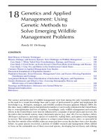
EARTH SCIENCE geology, the environment, and the universe 2008 (18)
Bạn đang xem bản rút gọn của tài liệu. Xem và tải ngay bản đầy đủ của tài liệu tại đây (5.35 MB, 34 trang )
The Dynamic Earth
Chapter 17
Plate Tectonics
BIG Idea Most geologic activity
occurs at the boundaries between
plates.
Chapter 18
Volcanism
BIG Idea Volcanoes develop
from magma moving upward from
deep within Earth.
Chapter 19
Earthquakes
BIG Idea Earthquakes are natural vibrations of the ground, some of
which are caused by movement
along fractures in Earth’s crust.
Chapter 20
Mountain Building
BIG Idea Mountains form
through dynamic processes which
crumple, fold, and create faults in
Earth’s crust.
464
CAREERS IN
EARTH SCIENCE
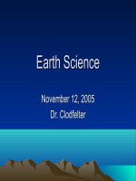
Volcanologist This
volcanologist is monitoring
volcanic activity to help forecast an
eruption. Volcanologists spend much of
their time in the field, collecting samples
and measuring changes in the shape of a
volcano.
Earth Science
Visit glencoe.com to learn more about
the work of volcanologists. Then
write a short newspaper article
about how volcanologists
predicted a recent
eruption.
To learn more about volcanologists,
visit glencoe.com.
Unit 5 • The Dynamic Earth 465
Krafft/Photo Researchers
Plate Tectonics
BIG Idea Most geologic
activity occurs at the boundaries between plates.
17.1 Drifting Continents
MAIN Idea The shape and
geology of the continents suggests that they were once joined
together.
17.2 Seafloor Spreading
MAIN Idea Oceanic crust
forms at ocean ridges and
becomes part of the seafloor.
17.3 Plate Boundaries
MAIN Idea Volcanoes, mountains, and deep-sea trenches
form at the boundaries between
the plates.
17.4 Causes of
Plate Motions
MAIN Idea Convection currents in the mantle cause plate
motions.
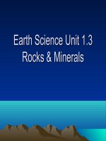
GeoFacts
• The San Andreas Fault is a
1200-km-long gash that runs
from northern California almost
to Mexico.
• Each year, plate movement
along the fault brings
Los Angeles about 5 cm closer
to San Francisco.
• In this photo, the North
American Plate is on the right,
the Pacific Plate is on the left.
466
Kevin Schafer/CORBIS
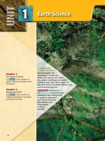
Start-Up Activities
Plate Boundaries Make this
Foldable to compare the types
of plate boundaries and their
features.
LAUNCH Lab
Is California moving?
Southwestern California is separated from the rest
of the state by a system of cracks along which movement takes place. These cracks are called faults. One
of these, as you might know, is the San Andreas Fault.
Movement along this fault is carrying southwestern
California to the Northwest in relation to the rest of
North America at a rate of about 5 cm/y.
STEP 1 Fold up the
bottom edge of a legalsized sheet of paper
about 3 cm and crease.
STEP 2
Fold the sheet
into thirds.
San
Andreas
Fault
0
300 km
San
Francisco
Los Angeles
N
Procedure
1. Read and complete the lab safety form.
2. Use a metric ruler and the map scale to
determine the actual distance between
San Francisco and Los Angeles.
3. At the current rate of movement, when will
these two cities be next to each other?
Analysis
1. Infer what might be causing the motion of
these large pieces of land.
2. Calculate How far will southwestern
California move in a 15-year period?
STEP 3 Glue or staple to make three pockets. Label the pockets
Divergent, Convergent,
and Transform.
ent
Diverg
Convergent Tran
sform
FOLDABLES Use this Foldable with Section 17.3. As
you read this section, summarize on index cards
or quarter sheets of paper the geologic characteristics of each type of boundary and the processes associated with it.
Visit glencoe.com to
study entire chapters online;
explore
•
Interactive Time Lines
•
Interactive Figures
•
Interactive Tables
animations:
access Web Links for more information, projects,
and activities;
review content with the Interactive
Tutor and take Self-Check Quizzes.
SectionChapter
1 • XXXXXXXXXXXXXXXXXX
17 • Plate Tectonics 467
Section 1 7.1
Objectives
◗ Identify the lines of evidence that
led Wegener to suggest that Earth’s
continents have moved.
◗ Discuss how evidence of ancient
climates supported continental drift.
◗ Explain why continental drift was
not accepted when it was first
proposed.
Drifting Continents
MAIN Idea The shape and geology of the continents suggests that
they were once joined together.
Real-World Reading Link When you put together a jigsaw puzzle, what fea-
tures of the puzzle pieces do you use to find matching pieces? Scientists used
features such as shape and position to help them piece together the way the
continents were arranged millions of years ago.
Review Vocabulary
hypothesis: testable explanation of
a situation
New Vocabulary
continental drift
Pangaea
Early Observations
With the exception of events such as earthquakes, volcanic eruptions, and landslides, most of Earth’s surface appears to remain relatively unchanged during the course of a human lifetime. On the
geologic time scale, however, Earth’s surface has changed dramatically. Some of the first people to suggest that Earth’s major features
might have changed were early cartographers. In the late 1500s,
Abraham Ortelius (or TEE lee us), a Dutch cartographer, noticed
the apparent fit of continents on either side of the Atlantic Ocean.
He proposed that North America and South America had been
separated from Europe and Africa by earthquakes and floods.
During the next 300 years, many scientists and writers noticed and
commented on the matching coastlines. Figure 17.1 shows a proposed map by a nineteenth-century cartographer.
The first time that the idea of moving continents was proposed
as a scientific hypothesis was in the early 1900s. In 1912, German
scientist Alfred Wegener (VAY guh nur) presented his ideas about
continental movement to the scientific community.
Reading Check Infer why cartographers were among the first to
suggest that the continents were once joined together.
Figure 17.1 Many early cartographers, such as Antonio SniderPelligrini, the author of these 1858
maps, noticed the apparent fit of the
continents.
■
468
Chapter 17 • Plate Tectonics
University of California, Berkeley
Before separation
After separation
Continental Drift
Wegener developed an idea that he called continental drift, which
proposed that Earth’s continents had once been joined as a single
landmass that broke apart and sent the continents adrift. He called
this supercontinent Pangaea (pan JEE uh), a Greek word that
means all the earth, and suggested that Pangaea began to break
apart about 200 mya. Since that time, he reasoned, the continents
have continued to slowly move to their present positions, as shown
in Figure 17.2.
Of the many people who had suggested that continents had
moved around, Wegener was the first to base his ideas on more
than just the puzzlelike fit of continental coastlines on either side
of the Atlantic Ocean. For Wegener, these gigantic puzzle pieces
were just the beginning. He also collected and organized rock, climatic, and fossil data to support his hypothesis.
Interactive Figure To see an animation of the
breakup of Pangaea, visit glencoe.com.
a
Pang
■ Figure 17.2 Wegener hypothesized that
all the continents were once joined together.
He proposed that it took 200 million years of continental drift for the continents to move to their
present positions.
Locate the parts of Pangaea that became
North and South America. When were they
joined? When were they separated?
ea
200 mya: All the continents assembled
in a single landmass that Wegener named
Pangaea.
180 mya: Continental rifting breaks
Pangaea into several landmasses. The North
Atlantic Ocean starts to form.
135 mya: Africa and South America
begin to separate.
Present: India has collided with Asia to form the
Himalayas and Australia has separated from
Antarctica. A rift valley is forming in East Africa.
Continents continue to move over Earth’s surface.
65 mya: India moves north toward Asia.
Section 1 • Drifting Continents 469
Evidence from rock formations Wegener reasoned that
when Pangaea began to break apart, large geologic structures, such
as mountain ranges, fractured as the continents separated. Using
this reasoning, Wegener thought that there should be areas of similar rock types on opposite sides of the Atlantic Ocean. He observed
that many layers of rocks in the Appalachian Mountains in the
United States were identical to layers of rocks in similar mountains
in Greenland and Europe. These similar groups of rocks, older than
200 million years, supported Wegener’s idea that the continents had
once been joined. Some of the locations where matching groups of
rock have been found are indicated in Figure 17.3.
■ Figure 17.3 Alfred Wegener used the
similarity of rock layers and fossils on opposite sides of the Atlantic Ocean as evidence
that Earth’s continents were once joined.
Identify groupings that suggest that
there was once a single landmass.
Evidence from fossils Wegener also gathered evidence of the
existence of Pangaea from fossils. Similar fossils of several different
animals and plants that once lived on or near land had been found
on widely separated continents, as shown in Figure 17.3. Wegener
reasoned that the land-dwelling animals, such as Cynognathus
(sin ug NATH us) and Lystrasaurus (lihs truh SORE us) could not
have swum the great distances that now exist between continents.
Wegener also argued that because fossils of Mesosaurus (meh zoh
SORE us), an aquatic reptile, had been found in only freshwater
rocks, it was unlikely that this species could have crossed the
oceans. The ages of these different fossils also predated Wegener’s
time frame for the breakup of Pangaea, and thus supported his
hypothesis.
North
America
Europe
Asia
Glossopteris
Atlantic Ocean
Africa
Equator
India
Pacific Ocean
South
America
Pacific Ocean
Indian Ocean
Cynognathus
Glossopteris
Lystrosaurus
Mesosaurus
Similar rock types
Matching mountain ranges
470
Chapter 17 • Plate Tectonics
(c)John Cancalosi/Peter Arnold, Inc., (r)Martin Land/Photo Researchers
Mesosaurus
Antarctica
Australia
Reading Check Infer how Wegener’s background in
meteorology helped him to support his idea of
continental drift.
■ Figure 17.4 A coal deposit in Antarctica indicates
that swamp plants once thrived in this area.
Explain How did coal, which forms from ancient
swamp material, end up in Antarctica?
Coal deposits Recall from Chapter 6 that sedimen-
tary rocks provide clues to past environments and climates. Wegener found evidence in these rocks that
the climates of some continents had changed markedly. For example, Figure 17.4 shows a coal deposit
found in Antarctica. Coal forms from the compaction
and decomposition of accumulations of ancient
swamp plants. The existence of coal beds in
Antarctica indicated that this frozen land once had a
tropical climate. Wegener used this evidence to conclude that Antarctica must have been much closer to
the equator sometime in the geologic past.
Figure 17.5 Glacial deposits nearly 300 million
years old on several continents led Wegener to propose
that these landmasses might have once been joined and
covered with ice. The extent of the ice is shown in white.
■
Glacial deposits Another piece of climatic evi-
dence came from glacial deposits found in parts of
Africa, India, Australia, and South America. The
presence of these 290-million-year-old deposits suggested to Wegener that these areas were once covered
by a thick ice cap similar to the one that covers
Antarctica today. Because the traces of the ancient
ice cap are found in regions where it is too warm
for them to develop, Wegener proposed that they
were once located near the south pole, as shown in
Figure 17.5. Wegener suggested two possibilities to
explain the deposits. Either the south pole had shifted
its position, or these landmasses had once been closer
to the south pole. Wegener argued that it was more
likely that the landmasses had drifted apart rather
than Earth changing its axis.
North
America
South
America
Eurasia
Africa
India
Antarctica
ali
a
Australian Government Antarctic Division © Commonwealth of Australia
Climatic evidence Because he had a strong
background in meteorology, Wegener recognized
clues about ancient climates from the fossils he studied. One fossil that Wegener used to support continental drift was Glossopteris (glahs AHP tur us),
a seed fern that resembled low shrubs, shown in
Figure 17.3. Fossils of this plant had been found on
many parts of Earth, including South America,
Antarctica, and India. Wegener reasoned that the
area separating these fossils was too large to have had
a single climate. Wegener also argued that because
Glossopteris grew in temperate climates, the places
where these fossils had been found were once closer
to the equator. This led him to conclude that the
rocks containing these fossil ferns had once been
joined.
tr
Aus
Section 1 • Drifting Continents 471
■ Figure 17.6 Wegener collected
further evidence for his theory on a
1930 expedition to Greenland. He died
during this expedition, many years
before his data became the basis for the
theory of plate tectonics.
Section 1 7.
7.1
1
In the early 1900s, many people in the scientific community considered the continents and ocean basins to be fixed features on
Earth’s surface. For the rest of his life, Wegener continued travelling to remote regions to gather evidence in support of continental drift. Figure 17.6 shows him in Greenland on his last
expedition. Although he had compiled an impressive collection
of data, the theory of continental drift was never accepted by the
scientific community.
Continental drift had two major flaws that prevented it from
being widely accepted. First, it did not satisfactorily explain what
force could be strong enough to push such large masses over such
great distances. Wegener thought that the rotation of Earth might
be responsible, but physicists were able to show that this force was
not nearly enough to move continents.
Second, scientists questioned how the continents were moving. Wegener had proposed that the continents were plowing
through a stationary ocean floor, but it was known that Earth’s
mantle below the crust was solid. So, how could continents move
through something solid? These two unanswered questions —
what forces could cause the movement and how continents could
move through solids — were the main reasons that continental
drift was rejected. It was not until the early 1960s that new technology revealed more evidence about how continents move that
scientists began to reconsider Wegener’s ideas. Advances in seafloor mapping and in understanding Earth’s magnetic field provided the necessary evidence to show how continents move, and
the source of the forces involved.
Assessment
Section Summary
Understand Main Ideas
◗ The matching coastlines of continents on opposite sides of the
Atlantic Ocean suggest that the continents were once joined.
1.
◗ Continental drift was the idea that
continents move around on Earth’s
surface.
◗ Wegener collected evidence from
rocks, fossils, and ancient climates to
support his theory.
◗ Continental drift was not accepted
because there was no explanation
for how the continents moved or
what caused their motion.
MAIN Idea
Draw how the continents were once adjoined as Pangaea.
2. Explain how ancient glacial deposits in Africa, India, Australia, and South America
support the idea of continental drift.
3. Summarize how rocks, fossils, and climate provided evidence of continental drift.
4. Infer what the climate in ancient North America must have been like as a part of
Pangaea.
Think Critically
5. Interpret Examine Figure 17.5. Oil deposits that are approximately 200 million
years old have been discovered in Brazil. Where might geologists find oil deposits of
a similar age?
6. Evaluate this statement: The town where I live has always been in the same place.
Earth Science
7. Compose a letter to the editor from a scientist in the early 1900s arguing against
continental drift.
472
Chapter 17 • Plate Tectonics
Self-Check Quiz glencoe.com
Alfred Wegener Institute
A Rejected Notion
Section 1 7. 2
Objectives
◗ Summarize the evidence that led
to the discovery of seafloor
spreading.
◗ Explain the significance of magnetic patterns on the seafloor.
◗ Explain the process of seafloor
spreading.
Review Vocabulary
basalt: a dark-gray to black finegrained igneous rock
New Vocabulary
magnetometer
magnetic reversal
paleomagnetism
isochron
seafloor spreading
Seafloor Spreading
MAIN Idea Oceanic crust forms at ocean ridges and becomes part
of the seafloor.
Real-World Reading Link Have you ever counted the rings on a tree stump
to find the age of the tree? Scientists can study similar patterns on the ocean
floor to determine its age.
Mapping the Ocean Floor
Until the mid-1900s, most people, including many scientists,
thought that the ocean floors were essentially flat. Many people
also had misconceptions that oceanic crust was unchanging and
was much older than continental crust. However, advances in technology during the 1940s and 1950s showed that all of these widely
accepted ideas were incorrect.
One technological advance that was used to study the ocean floor
was the magnetometer. A magnetometer (mag nuh TAH muh tur),
such as the one shown in Figure 17.7, is a device that can detect
small changes in magnetic fields. Towed behind a ship, it can record
the magnetic field generated by ocean floor rocks. You will learn
more about magnetism and how it supports continental drift later in
this section.
Another advancement that allowed scientists to study the ocean
floor in great detail was the development of echo-sounding methods. One type of echo sounding is sonar. Recall from Chapter 15
that sonar uses sound waves to measure distance by measuring the
time it takes for sound waves sent from the ship to bounce off the
seafloor and return to the ship. Developments in sonar technology
enabled scientists to measure water depth and map the topography
of the ocean floor.
Figure 17.7 Magnetometers are
devices that can detect small changes in
magnetic fields. The data collected using
magnetometers lowered into the ocean
furthered scientists’ understanding of rocks
underlying the ocean floor.
■
Section 2 • Seafloor Spreading 473
John F. Williams/U.S. Navy/Getty Images
■ Figure 17.8 Sonar data revealed
ocean ridges and deep-sea trenches.
Earthquakes and volcanism are common along ridges and trenches.
Juan de
Fuca Ridge
Marianas
Trench
Southeast
Indian Ridge
East
Pacific
Rise
Central
Indian
Ridge
Mid-Atlantic
Ridge
Southwest
Indian
Ridge
Pacific
Antarctic
Ridge
Chile
Ridge
Ocean-Floor Topography
The maps made from data collected by sonar and magnetometers
surprised many scientists. They discovered that vast, underwater
mountain chains called ocean ridges run along the ocean floors
around Earth much like seams on a baseball. These ocean floor
features, shown in Figure 17.8, form the longest continuous
mountain range on Earth. When they were first discovered, ocean
ridges generated much discussion because of their enormous
length and height—they are more than 80,000 km long and up to
3 km above the ocean floor. Later, scientists discovered that earthquakes and volcanism are common along the ridges.
Reading Check Describe Where are the longest continuous moun-
tain ranges on Earth?
VOCABULARY
SCIENCE USAGE V. COMMON USAGE
Depress
Science usage: to cause to sink to a
lower position
Common usage: to sadden or
discourage
474
Chapter 17 • Plate Tectonics
Maps generated with sonar data also revealed that underwater
mountain chains had counterparts called deep-sea trenches, which
are also shown on the map in Figure 17.8. Recall from Chapter 16
that a deep-sea trench is a narrow, elongated depression in the seafloor. Trenches can be thousands of kilometers long and many kilometers deep. The deepest trench, called the Marianas Trench, is in
the Pacific Ocean and is more than 11 km deep. Mount Everest, the
world’s tallest mountain, stands at 9 km above sea level, and could
fit inside the Marianas Trench with six Empire State buildings
stacked on top.
These two topographic features of the ocean floor — ocean
ridges and deep-sea trenches— puzzled geologists for more than
a decade after their discovery. What could have formed an underwater mountain range that extended around Earth? What is the
source of the volcanism associated with these mountains? What
forces could depress Earth’s crust enough to create trenches nearly
6 times as deep as the Grand Canyon? You will find out the answers
to these questions later in this chapter.
Ocean Rocks and Sediments
In addition to making maps, scientists collected samples of deep-sea
sediments and the underlying oceanic crust. Analysis of the rocks
and sediments led to two important discoveries. First, the ages of the
rocks that make up the seafloor varies across the ocean floor, and
these variations are predictable. Rock samples taken from areas near
ocean ridges were found to be younger than samples taken from
areas near deep-sea trenches. The samples showed that the age of
oceanic crust consistently increases with distance from a ridge, as
shown in Figure 17.9. This trend was symmetric across the ocean
ridges. Scientists also discovered from the rock samples that even the
oldest parts of the seafloor are geologically young—about 180 million years old. Why are ocean-floor rocks so young compared to
continental rocks, some of which are at least 3.8 billion years old?
Geologists knew that oceans had existed for more than 180 million
years so they wondered why there was no trace of older oceanic
crust.
The second discovery involved the sediments on the ocean floor.
Measurements showed that ocean-floor sediments are typically a
few hundred meters thick. Large areas of continents, on the other
hand, are blanketed with sedimentary rocks that are as much as 20
km thick. Scientists knew that erosion and deposition occur in
Earth’s oceans but did not understand why seafloor sediments were
not as thick as their continental counterparts. Scientists hypothesized that the relatively thin layer of ocean sediments was related to
the age of the ocean crust. Observations of ocean-floor sediments
revealed that the thickness of the sediments increases with distance
from an ocean ridge, as shown in Figure 17.9. The pattern of
thickness across the ocean floor was symmetrical across the ocean
ridges.
Careers In Earth Science
Marine geologist Earth scientists
who study the ocean floor to
understand geologic processes such
as plate tectonics are marine
geologists. To learn more about Earth
science careers, visit glencoe.com.
Figure 17.9 The ages of
ocean crust and the thicknesses
of ocean-floor sediments increase
with distance from the ridge.
■
Ocean ridge
Thick sediment
Thin sediment
Young rocks
Old rocks
Crust
Crust
Section 2 • Seafloor Spreading 475
■ Figure 17.10 Earth’s magnetic
field is generated by the flow of molten
iron in the liquid outer core. The polarity
of the field changes over time from normal to reversed.
N
S
N
Normalmagnetic
magnetic field
Normal
field
S
Reversedmagnetic
magnetic field
Reversed
field
Magnetism
■
Figure 17.11 Periods of normal
polarity alternate with periods of
reversed polarity. Long-term changes in
Earth’s magnetic field, called epochs,
are named as shown here. Short-term
changes are called events.
0.0
Magnetic epochs
Brunhes
normal epoch
1.0
Age (mya)
Matuyama
reversed epoch
2.0
3.0
4.0
Gauss
normal epoch
Gilbert
reversed epoch
Normal
polarity
5.0
476
Reversed
polarity
Chapter 17 • Plate Tectonics
Earth has a magnetic field generated by the flow of molten iron in
the outer core. This field is what causes a compass needle to point
to the North. A magnetic reversal happens when the flow in the
outer core changes, and Earth’s magnetic field changes direction.
This would cause compasses to point to the South. Magnetic reversals have occurred many times in Earth’s history. As shown in
Figure 17.10, a magnetic field that has the same orientation as
Earth’s present field is said to have normal polarity. A magnetic
field that is opposite to the present field has reversed polarity.
Magnetic polarity time scale Paleomagnetism is the
study of the history of Earth’s magnetic field. When lava solidifies,
iron-bearing minerals such as magnetite crystallize. As they crystallize, these minerals behave like tiny compasses and align with
Earth’s magnetic field. Data gathered from paleomagnetic studies of
continental lava flows allowed scientists to construct a magnetic
polarity time scale, as shown in Figure 17.11.
Magnetic symmetry Scientists knew that oceanic crust is
mostly basaltic rock, which contains large amounts of iron-bearing
minerals of volcanic origin. They hypothesized that the rocks on the
ocean floor would show a record of magnetic reversals. When scientists towed magnetometers behind ships to measure the magnetic
orientation of the rocks of the ocean floor, a surprising pattern
emerged. The regions with normal and reverse polarity formed a
series of stripes across the floor parallel to the ocean ridges. The scientists were doubly surprised to discover that the ages and widths of
the stripes matched from one side of the ridges to the other.
Compare the magnetic pattern on opposite sides of the ocean ridge
shown in Figure 17.12.
Figure 17.12 Reversals in the polarity of Earth’s
magnetic field are recorded in the rocks that make up the
ocean floor.
Identify the polarity of the most recently produced
basalt at the ocean ridge.
rt
Gil
be
ma
Bru
nh
Bru es
nh
es
Ma
tuy
am
a
Ga
uss
ya
Ma
tu
ss
Ga
u
Gi
l be
rt
■
Normal
polarity
5.0 3.3
2.5 0.7 0 0.7 2.5 3.3
Age of crust (millions of years)
5.0
Reversed
polarity
By matching the patterns on the seafloor with the known pattern of reversals on land, scientists were able to determine the age
of the ocean floor from magnetic recording. This method enabled
scientists to quickly create isochron (I suh krahn) maps of the
ocean floor. An isochron is an imaginary line on a map that shows
points that have the same age—that is, they formed at the same
time. In the isochron map shown in Figure 17.13, note that relatively young ocean-floor crust is near ocean ridges, while older
ocean crust is found along deep-sea trenches.
■ Figure 17.13 Each colored band
on this isochron map of the ocean floor
represents the age of that strip of the crust.
Observe What pattern do you observe?
Section 2 • Seafloor Spreading 477
National Geophysical Data Center/NOAA/NGDC
Master Page used: NGS
Visualizing Seafloor Spreading
Figure 17.14 Data from topographic, sedimentary, and paleomagnetic research led scientists to propose
seafloor spreading. Seafloor spreading is the process by which new oceanic crust forms at ocean ridges, and
slowly moves away from the spreading center until it is subducted and recycled at deep-sea trenches.
Deep-sea
trench
Magma intrudes into the ocean floor
along a ridge and fills the gap that is
created. When the molten material
solidifies, it becomes new oceanic crust.
Ocean ridge
Deep-sea
trench
Continental
crust
Magma
intrudes
Oceanic
crust
Mantle
The continuous spreading and intrusion
of magma result in the addition of new
oceanic crust. Two halves of the oceanic
crust spread apart slowly, and move
apart like a conveyor belt.
Crust melts
Crust melts
The far edges of the oceanic crust sink
beneath continental crust. As it
descends, water in the minerals causes
the oceanic crust to melt, forming
magma. The magma rises and forms
part of the continental crust.
To explore more about seafloor
spreading, visit glencoe.com.
478
Chapter 17 • Plate Tectonics
S. Jonasson/FLPA
Seafloor Spreading
Using all the topographic, sedimentary, and paleomagnetic data
from the seafloor, seafloor spreading was proposed. Seafloor
spreading is the theory that explains how new ocean crust is
formed at ocean ridges and destroyed at deep-sea trenches.
Figure 17.14 illustrates how seafloor spreading occurs.
During seafloor spreading, magma, which is hotter and less
dense than surrounding mantle material, is forced toward the surface of the crust along an ocean ridge. As the two sides of the ridge
spread apart, the rising magma fills the gap that is created. When
the magma solidifies, a small amount of new ocean floor is added
to Earth’s surface. As spreading along a ridge continues, more
magma is forced upward and solidifies. This cycle of spreading and
the intrusion of magma continues the formation of ocean floor,
which slowly moves away from the ridge. Of course, seafloor
spreading mostly happens under the sea, but in Iceland, a portion
of the Mid-Atlantic Ridge rises above sea level. Figure 17.15
shows lava erupting along the ridge.
Recall that while Wegener collected many data to support the
idea that the continents are drifting across Earth’s surface, he could
not explain what caused the landmasses to move or how they
moved. Seafloor spreading was the missing link that Wegener
needed to complete his model of continental drift. Continents are
not pushing through ocean crust, as Wegener proposed. In fact,
continents are more like passengers that ride along while ocean
crust slowly moves away from ocean ridges. Seafloor spreading led
to a new understanding of how Earth’s crust and rigid upper mantle
move. This will be explored in the next sections.
Section 1 7. 2
■ Figure 17.15 The entire island of
Iceland lies on the Mid-Atlantic ocean
spreading center. Because the seafloor is
spreading, Iceland is growing larger. In
1783, more than 12 km3 of lava erupted—enough to pave the entire U.S. interstate freeway system to a depth of 10 m.
Assessment
Section Summary
Understand Main Ideas
◗ Studies of the seafloor provided evidence that the ocean floor is not flat
and unchanging.
1.
◗ Oceanic crust is geologically young.
3. Differentiate between the terms reversed polarity and normal polarity.
◗ New oceanic crust forms as magma
rises at ridges and solidifies.
4. Describe the topography of the seafloor.
◗ As new oceanic crust forms, the
older crust moves away from the
ridges.
5. Explain how an isochron map of the ocean floor supports the theory of seafloor
spreading.
MAIN Idea
Describe why seafloor spreading is like a moving conveyor belt.
2. Explain how ocean-floor rocks and sediments provided evidence of seafloor
spreading.
Think Critically
6. Analyze Why are magnetic bands in the eastern Pacific Ocean so far apart
compared to the magnetic bands along the Mid-Atlantic Ridge?
MATH in Earth Science
7. Analyze Figure 17.11. What percentage of the last 5 million years has been spent
in reversed polarity?
Self-Check Quiz glencoe.com
Section 2 • Seafloor Spreading 479
Section 1 7. 3
Objectives
◗ Describe how Earth’s tectonic
plates result in many geologic
features.
◗ Compare and contrast the three
types of plate boundaries and the
features associated with each.
◗ Generalize the processes associated with subduction zones.
Plate Boundaries
MAIN Idea Volcanoes, mountains, and deep-sea trenches form at
the boundaries between the plates.
Real-World Reading Link Imagine a pot of soup that has been allowed to
cool in a refrigerator. Fats in the soup have solidified into a hard surface, but if
you tilt the pot back and forth, you will see the rigid surface bending and cracking. This is similar to the relationship between different layers of Earth.
Review Vocabulary
mid-ocean ridge: a major feature
along the ocean floor consisting of an
elevated region with a central valley
New Vocabulary
tectonic plate
divergent boundary
rift valley
convergent boundary
subduction
transform boundary
Theory of Plate Tectonics
The evidence for seafloor spreading suggested that continental and
oceanic crust move as enormous slabs, which geologists describe
as tectonic plates. Tectonic plates are huge pieces of crust and rigid
upper mantle that fit together at their edges to cover Earth’s surface.
As illustrated in Figure 17.16, there are about 12 major plates and
several smaller ones. These plates move very slowly—only a few centimeters each year—which is similar to the rate at which fingernails
grow. Plate tectonics is the theory that describes how tectonic plates
move and shape Earth’s surface. They move in different directions
and at different rates relative to one another and they interact with
one another at their boundaries. Each type of boundary has certain
geologic characteristics and processes associated with it. A divergent
boundary occurs where tectonic plates move away from each other.
A convergent boundary occurs where tectonic plates move toward
each other. A transform boundary occurs where tectonic plates
move horizontally past each other.
Figure 17.16 Earth’s crust and rigid upper mantle are broken into enormous slabs called tectonic
plates that interact at their boundaries.
■
Juan
de Fuca
Plate
North
American
Plate
Caribbean
Plate
Eurasian Plate
Philippine
Plate
African Plate
Nazca
Plate
South
American
Plate
Scotia Plate
480 Chapter 17 • Plate Tectonics
Divergent
boundary
Convergent
boundary
Plate
boundary
Arabian
Plate
Cocos
Plate
Pacific
Plate
North
American
Plate
Indo-Australian
Plate
Antarctic Plate
Pacific Plate
Divergent boundaries Regions where
two tectonic plates are moving apart are called
divergent boundaries. Most divergent boundaries
are found along the seafloor, where they form midocean ridges, as shown in Figure 17.17. The actual
plate boundary is located in a fault-bounded valley
called a rift, which forms along a ridge. It is in this
central rift that the process of seafloor spreading
begins. The formation of new ocean crust at most
divergent boundaries accounts for the high heat flow,
volcanism, and earthquakes associated with these
boundaries.
Rift
valley
Reading Check Identify the cause of volcanism and
earthquakes associated with mid-ocean ridges.
Throughout millions of years, the process of seafloor spreading along a divergent boundary can cause
an ocean basin to grow wider. Although most divergent boundaries form ridges on the ocean floor, some
divergent boundaries form on continents. When continental crust begins to separate, the stretched crust
forms a long, narrow depression called a rift valley.
Figure 17.17 shows the rift valley that is currently
forming in East Africa. The rifting might eventually
lead to the formation of a new ocean basin.
Divergent boundary
Figure 17.17 Divergent boundaries are places where
plates separate. An ocean ridge is a divergent boundary on
the ocean floor. In East Africa, a divergent boundary has
also created a rift valley.
■
Model Ocean-Basin Formation
How did a divergent boundary form the South Atlantic Ocean? Around 150 mya, a divergent
boundary split an ancient continent. Over time, new crust was added along the boundary, widening the
rift between Africa and South America.
Procedure
1. Read and complete the lab safety form.
2. Use a world map to create paper templates of South America and Africa.
3. Place the two continental templates in the center of a large piece of paper, and fit them together
along their Atlantic coastlines.
4. Carefully trace around the templates with a pencil. Remove the templates and label the diagram
150 mya.
5. Use an average spreading rate of 4 cm/y and a map scale of 1 cm = 500 km to create six maps that
show the development of the Atlantic Ocean at 30-million-year intervals, beginning 150 mya.
Analyze and Conclude
1. Compare your last map with a world map. Is the actual width of the South Atlantic Ocean the
same on both maps?
2. Consider why there might be differences between the width in your model and the actual width
of the present South Atlantic Ocean.
Section 3 • Plate Boundaries 481
Altitude/Peter Arnold, Inc.
Basalt
Convergent boundaries At convergent
boundaries, two tectonic plates are moving toward
each other. When two plates collide, the denser plate
eventually descends below the other, less-dense plate
in a process called subduction. There are three types
of convergent boundaries, classified according to
the type of crust involved. Recall from Chapter 1
that oceanic crust is made mostly of minerals that
are high in iron and magnesium, which form dense,
dark-colored basaltic rocks, such as the basalt
shown in Figure 17.18. Continental crust is composed mostly of minerals such as feldspar and
quartz, which form less-dense, lighter-colored granitic rocks. The differences in density of the crustal
material affects how they converge. The three types
of tectonic boundaries and their associated landforms are shown in Table 17.1.
Oceanic-oceanic In the oceanic-oceanic convergent boundary shown in Table 17.1, a subduction
Granite
■ Figure 17.18 Oceanic plates are mostly basalt.
Continental plates are mostly granite with a thin cover of
sedimentary rock, both of which are less dense than basalt.
VOCABULARY
ACADEMIC VOCABULARY
Parallel (PAIR uh lel)
extending in the same direction,
everywhere equidistant, and not
meeting
The commuter train runs parallel to
the freeway for many kilometers.
482
Chapter 17 • Plate Tectonics
(t)Joyce Photographics/Photo Researchers, (b)Andrew J. Martinez/Photo Researchers
zone is formed when one oceanic plate, which is
denser as a result of cooling, descends below another
oceanic plate. The process of subduction creates a
deep-sea trench. The subducted plate descends into
the mantle, thereby recycling oceanic crust formed at
the ridge. Water carried into Earth by the subducting
plate changes the melting temperature of the plate,
causing it to melt. The molten material, called
magma, is less dense so it rises back to the surface,
where it often erupts and forms an arc of volcanic
islands that parallel the trench. Some examples of
trenches and island arcs are the Marianas Trench and
Marianas Islands in the West Pacific Ocean and the
Aleutian Trench and Aleutian Islands in the North
Pacific Ocean. A volcanic peak in the Aleutian Island
arc is shown in Table 17.1.
Oceanic-continental Subduction zones are also
found where an oceanic plate converges with a continental plate, as shown in Table 17.1. Note that it is
the denser oceanic plate that is subducted. Oceaniccontinental convergence also produces a trench and
volcanic arc. However, instead of forming an arc of
volcanic islands, oceanic-continental convergence
results in a chain of volcanoes along the edge of the
continental plate. The result of this type of subduction is a mountain range with many volcanoes. The
Peru-Chile Trench and the Andes mountain range,
which are located along the western coast of South
America, formed in this way.
Table 17.1
Summary of Convergent Boundaries
Type of Convergent Boundary
Interactive Table To explore
more about convergent boundaries, visit glencoe.com.
Example of Region Affected
by Boundary
Example of Landform Produced
Aleutian Islands
Chagulak Island, Alaska
Andes mountain range
Osorno Volcano, Chile
Himalayas
Ama Dablan, Nepal
Oceanic-oceanic
Volcanic
island arc
Ocean
trench
Oceanic
crust
Magma
Subducting
plate
Mantle
Oceanic-continental
Volcanic
mountain
range
Ocean
Oceanic trench
crust
Magma
Continental crust
Sub
du
ctin
gp
lat
e
Mantle
Continental-continental
Continental crust
Mantle
Ancient
oceanic crust
Section 3 • Plate Boundaries 483
(l to r, t to b)NASA/Photo Researchers, (2)Kevin Schafer/Peter Arnold, Inc., (3)Jeff Schmaltz/NASA, (4)Ed Viggiani/Getty Images, (5)Firstlight/Getty Images, (6)Woodfall/WWI/Peter Arnold, Inc.
Continental-continental The third type of convergent boundary
forms when two continental plates collide. Continental-continental
boundaries form long after an oceanic plate has converged with a continental plate. Recall that continents are often carried along attached
to oceanic crust. Over time, an oceanic plate can be completely subducted, dragging an attached continent behind it toward the subduction zone. As a result of its denser composition, oceanic crust descends
beneath the continental crust at the subduction zone. The continental
crust that it pulls behind it cannot descend because continental rocks
are less dense, and will not sink into the mantle. As a result, the edges
of both continents collide, and become crumpled, folded, and uplifted.
This forms a vast mountain range, such as the Himalayas, as shown in
Table 17.1.
FOLDABLES
Incorporate information
from this section into
your Foldable.
Transform boundaries A region where two plates slide
horizontally past each other is a transform boundary, as shown
in Figure 17.19. Transform boundaries are characterized by
long faults, sometimes hundreds of kilometers in length, and by
shallow earthquakes. Transform boundaries were named for the
way Earth’s crust changes, or transforms, its relative direction and
velocity from one side of the boundary to the other. Recall that
new crust is formed at divergent boundaries and destroyed at
convergent boundaries. Crust is only deformed or fractured
somewhat along transform boundaries.
PROBLEM-SOLVING Lab
Interpret Scientific
Illustrations
How does plate motion change along a transform boundary? The figure at the right shows
5. Assess Which two locations represent the
oldest crust?
the Gibbs Fracture Zone, which is a segment of
the Mid-Atlantic Ridge located south of Iceland
and west of the British Isles. Copy this figure.
Analysis
1. Draw arrows on your copy to indicate the
direction of seafloor movement at locations
A, B, C, D, E, and F.
2. Compare the direction of motion for the
following pairs of locations: A and D, B and
E, and C and F.
Think Critically
3. Differentiate Which three locations are on
the North American Plate?
4. Indicate the portion of the fracture zone
that is the boundary between North America
and Europe.
484
Marie Tharp
Chapter 17 • Plate Tectonics
A
B
C
D
E
F
Albert Copley/Visuals Unlimited
■ Figure 17.19 Plates move horizontally past each other along a transform plate boundary. The bend in these train tracks resulted from the transform boundary running through parts of Southern California.
Transform fault
Most transform boundaries offset sections of ocean ridges, as you
observed in the Problem-Solving Lab. Sometimes transform boundaries occur on continents. The San Andreas Fault is probably the
best-known example. Recall from the Launch Lab at the beginning
of this chapter that the San Andreas Fault system is part of a transform boundary that separates southwestern California from the rest
of the state. Movements along this transform boundary create situations like the one shown in Figure 17.19 and are responsible for
most of the earthquakes that strike California every year.
Section 1 7. 3
Assessment
Section Summary
Understand Main Ideas
◗ Earth’s crust and rigid upper mantle
are broken into large slabs of rock
called tectonic plates.
1.
◗ Plates move in different directions
and at different rates over Earth’s
surface.
3. List the geologic features associated with each type of convergent boundary.
◗ At divergent plate boundaries, plates
move apart. At convergent boundaries, plates come together. At transform boundaries, plates slide
horizontally past each other.
MAIN Idea Describe how plate tectonics results in the development of Earth’s
major geologic features.
2. Summarize the processes of convergence that formed the Himalayan mountains.
4. Identify the type of location where transform boundaries most commonly occur.
Think Critically
5. Choose three plate boundaries in Figure 17.16, and predict what will happen
over time at each boundary.
6. Describe how two portions of newly formed crust move between parts of a ridge
that are offset by a transform boundary.
◗ Each type of boundary is characterized by certain geologic features.
Earth Science
7. Write a news report on the tectonic activity that is occurring at the Aleutian Islands
in Alaska.
Self-Check Quiz glencoe.com
Section 3 • Plate Boundaries 485
Section 1 7. 4
Objectives
◗ Explain the process of convection.
◗ Summarize how convection in the
mantle is related to the movements
of tectonic plates.
◗ Compare and contrast the processes of ridge push and slab pull.
Review Vocabulary
convection: the circulatory motion
that occurs in a fluid at a nonuniform
temperature owing to the variation of
its density and the action of gravity
New Vocabulary
ridge push
slab pull
■ Figure 17.20 Water cooled by the ice
cube sinks to the bottom where it is warmed by
the burner and rises. The process continues as
the ice cube cools the water again.
Infer what will happen to the ice cube due
to convection currents.
Causes of Plate Motions
MAIN Idea Convection currents in the mantle cause plates to move.
Real-World Reading Link You probably know a lava lamp does not contain
real lava, but the materials inside a lava lamp behave much like the molten rock
within Earth.
Convection
One of the main questions about the theory of plate tectonics has
remained unanswered since Alfred Wegener first proposed continental drift. What force or forces cause tectonic plates to move?
Many scientists now think that large-scale motion in the mantle — Earth’s interior between the crust and the core — is the mechanism that drives the movement of tectonic plates.
Convection currents Recall from Chapter 11 that convection
is the transfer of thermal energy by the movement of heated material
from one place to another. As in a lava lamp, the cooling of matter
causes it to contract slightly and increase in density. The cooled
matter then sinks as a result of gravity. Warmed matter is then displaced and forced to rise. This up-and-down flow produces a pattern of motion called a convection current. Convection currents
aid in the transfer of thermal energy from warmer regions of matter to cooler regions. A convection current can be observed in the
series of photographs shown in Figure 17.20. Earth’s mantle is
composed of partially molten material that is heated unevenly by
radioactive decay from both the mantle itself and the core beneath
it. Radioactive decay heats up the molten material in the mantle
and causes enormous convection currents to move material
throughout the mantle.
Beaker
with
H2O
Ice
cube
Drops of
blue food
coloring
Burner
486 Chapter 17 • Plate Tectonics
Richard Megna/Fundamental Photographs
Convection
current
Figure 17.21 Convection currents develop in
the mantle, moving the crust and outermost part of
the mantle, and transferring thermal energy from
the Earth’s interior to its exterior.
■
Subducting
slab
Subducting
slab
Mantle
Co
nve
ction
currents
Convection in the mantle Convection currents in the mantle,
illustrated in Figure 17.21, are thought to be the driving mechanism
of plate movements. Recall that even though the mantle is a solid,
much of it moves like a soft, pliable plastic. The part of the mantle
that is too cold and stiff to flow lies beneath the crust and is attached
to it, moving as a part of tectonic plates. In the convection currents of
the mantle, cooler mantle material is denser than hot mantle material.
Mantle that has cooled at the base of tectonic plates slowly sinks
downward toward the center of Earth. Heated mantle material near
the core is then displaced, and like the wax warmed in a lava lamp, it
rises. Convection currents in the mantle are sustained by this rise and
fall of material which results in a transfer of energy between Earth’s
hot interior and its cooler exterior. Although convection currents can
be thousands of kilometers across, they flow at rates of only a few
centimeters per year. Scientists think that these convection currents
are set in motion by subducting slabs.
Reading Check Discuss Which causes a convection current to flow:
the rising of hot material, or the sinking of cold material?
Plate movement How are convergent and divergent movements of tectonic plates related to mantle convection? The rising
material in the convection current spreads out as it reaches the
upper mantle and causes both upward and sideways forces. These
forces lift and split the lithosphere at divergent plate boundaries.
As the plates separate, material rising from the mantle supplies the
magma that hardens to form new ocean crust. The downward part
of a convection current occurs where a sinking force pulls tectonic
plates downward at convergent boundaries.
Section 4 • Causes of Plate Motions 487
■ Figure 17.22 Ridge push and slab
pull are two of the processes that move tectonic plates over the surface of Earth.
Ocean ridge
Trench
Continent
Ridge
push
Trench
Interactive Figure To see an animation of
ridge push and slab pull, visit glencoe.com.
Continent
Slab
pull
Mantle
Slab
pull
Outer core
Inner
core
Push and Pull
Scientists hypothesize that there are several processes that determine
how mantle convection affects the movement of tectonic plates.
Study Figure 17.22. As oceanic crust cools and moves away from
a divergent boundary, it becomes denser and sinks compared to the
newer, less-dense oceanic crust. As the older portion of the seafloor
sinks, the weight of the uplifted ridge is thought to push the oceanic
plate toward the trench formed at the subduction zone in a process
called ridge push.
A second and possibly more significant process that determines
the movement of tectonic plates is called slab pull. In slab pull, the
weight of a subducting plate pulls the trailing slab into the subduction zone much like a tablecloth slipping off the table can pull articles
off with it. It is likely that combination of mechanisms such as these
are involved in plate motions at subduction zones.
Section 1 7 . 4
Assessment
Section Summary
Understand Main Ideas
◗ Convection is the transfer of energy
via the movement of heated matter.
1.
◗ Convection currents in the mantle
result in an energy transfer between
Earth’s hot interior and cooler
exterior.
2. Restate the relationships among mantle convection, ocean ridges, and subduction
zones.
◗ Plate movement results from the processes called ridge push and slab
pull.
MAIN Idea Draw a diagram comparing convection in a pot of water with convection in Earth’s mantle. Relate the process of convection to plate movement.
3. Make a model that illustrates the tectonic processes of ridge push and slab pull.
Think Critically
4. Evaluate this statement: Convection currents only move oceanic crust.
5. Summarize how convection is responsible for the arrangement of continents on
Earth’s surface.
Earth Science
6. Write dictionary definitions for ridge push and slab pull without using those terms.
488
Chapter 17 • Plate Tectonics
Self-Check Quiz glencoe.com