Nguyen an thinh and luc hens 2017 a dig
Bạn đang xem bản rút gọn của tài liệu. Xem và tải ngay bản đầy đủ của tài liệu tại đây (2.57 MB, 10 trang )
Vietnam Journal of Earth Sciences, 39(1), 87-96
Vietnam Academy of Science and Technology
Vietnam Journal of Earth Sciences
(VAST)
/>
A Digital Shoreline Analysis System (DSAS) applied on
mangrove shoreline changes along the Giao Thuy Coastal
area (Nam Dinh, Vietnam) during 2005-2014
Nguyen An Thinh1*, Luc Hens2
1
Hanoi University of Natural Resources and Environment (HUNRE), Vietnam
2
Flemish Institute for Technological Research (VITO), Belgium
Received 10 November 2016. Accepted 12 February 2017
ABSTRACT
The paper deals with a combination of the Digital Shoreline Analysis System (DSAS) and remote sensing, studying historical mangrove shoreline changes and mangrove zoning in the Giao Thuy coastal area of the Nam Dinh province, Vietnam. The results show an over-all mangrove area increase of 2,487 hectares during the years 2005-2014.
This dynamics results from both degradation and increase of the mangroves. The calculated degradation rate is 1.41
m yr-1, and the growth rate is 1.26 m yr-1 on average. 4 different mangrove zones were delineated based on the End
Point Rate (EPR) values of DSAS transects. The differential evolution of the mangroves in these zones is driven by
socio-economic and environmental factors. The results contribute to practices of mangrove planning and management
in a coastal area. Furthermore, historical mangrove shoreline change provides indicators to monitor coastal environmental changes for global warming, climate change, storm effects, sea level change, pollution, and sedimentation
rates.
Keywords: Digital Shoreline Analysis System (DSAS), mangrove shoreline changes, mangrove zoning, transect,
Giao Thuy coast, Vietnam.
©2017 Vietnam Academy of Science and Technology
1. Introduction1
Mangroves provide a variety of beneficial
ecosystem services such as protecting shorelines, accelerating sediment accretions, and
buffering shorelines from erosion by storms
and waves (Sathirathai and Barbier, 2001).
Combinations of both natural and human driving forces cause significant mangrove changes
*
Corresponding author, Email:
along the coasts. Considerable natural driving
forces include storm damage, and changes in
rainfall, tidal regimes and sea level (Ellison,
2000; Lewis, 2005); whereas, urbanization,
industrialization, and aquaculture are considered main human contributing factors to mangrove changes (Cohen and Lara, 2003; Rebelo
et al., 2009; Tran et al., 2014). The reconstruction of mangrove changes allows identifying historical coastline dynamics, assessing
the intensity and impact of natural hazards
87
Nguyen An Thinh and Luc Hens/Vietnam Journal of Earth Sciences 39 (2017)
and developments in coastal areas, among
others in the context of global climate change
(Alongi, 2008). Traditionally, remote sensing
and GIS were recommended to detect and describe mangrove changes. To this end, both
aerial photos and satellite images were used.
More recently the combination of remote
sensing and GIS with spatial models as fractal
analysis (Nguyen et al., 2015) or Digital
Shoreline Analysis System (DSAS) (Thieler
et al., 2009) was used. Because DSAS is effective for calculating changing rates of mangrove boundary changes incorporating an evidently -identified attribute position at separate
times (Cohen and Lara, 2003; Sheik and
Chandrasekar, 2011), it is able to provide a
better understanding of the nature, dynamics
and trend of mangrove shoreline change.
DSAS applications to study shoreline dynamics in coastal areas are found in the USA,
Turkey, Italy, Cameroon, Ghana, India, Bangladesh, and Vietnam - just listing these examples (Moussaid et al., 2015; Hegde and
Akshaya, 2015). Vietnamese research using
DSAS showed shoreline changes in the Nam
Dinh coast (To and Thao, 2008), Kien Giang
coast (Nguyen et al., 2015), and in the MuiCa
Mau coast, where long-term changes were
documented (Tran et al., 2014). To and Thao
(2008) indicates that the shoreline moved
forward 37-39 meters in Xuan Thuy coast
during 1905-1992; whereas, Nguyen et al.,
2015 show that mangrove extent in Kien
Giang coast decreased during period 19891992, increased during 1992-2003, and decreased during 2003-2006.
The GiaoThuy district has a volatile economy on the move, in particular in its central
area and along the coast. The largest, partially
protected mangrove area of the Red River Biosphere Reserve (BR), is found in the Xuan
Thuy National Park (NP) along the coast of
Giao Thuy. Tidal alluvial soil covers the area,
which facilitates the growth of the mangrove
forest (Vu, 2016). Mangroves in this area
changed significantly over last centuries
(Pham and Nguyen, 2016); their surface in88
creased since the last ten years. However, urbanization, agro-aquaculture, and marine infrastructure construction recently caused
mangrove degradation in specific locations.
Moreover, climate change hazards as storms,
floods, and sea level rise synergistically contribute to the degradation. To counteract this
degradation, strategic spatial planning targeted at sustainable mangrove management, and
addressing the conflicts between mangrove
protection and socio-economic development is
most necessary.
This paper aims at zoning the mangroves
along the coast of Giao Thuy based on mangrove shoreline changes during the period
2005-2014. Rates of mangrove shoreline degradation and increaseare calculated using
DSAS data derived from LANDSAT satellite
images.
2. Material and methods
2.1. Study area
The coastline of GiaoThuy is 32 kilometers
long and stretches along the northeast of the
Nam Dinh province (Figure 1). The coastal
communes are Giao Thien, Giao An, Giao
Lac, Giao Xuan, Giao Hai, Giao Long, Bach
Long, Giao Phong, and Quat Lam. As part of
the Red River Delta, this area has two estuaries - Ba Lat and Day- where most mangroves
are found. Xuan Thuy NP which is located in
the south of the Ba Lat estuary, is planned as
the core area of the Red River BR. This is the
first RAMSAR site in Southeast Asia since
the Convention took effect in 1989. Most
mangroves in Giao Thuy are found in the
Xuan Thuy NP and in the Ba Lat estuary. Almost all the mangrove trees were planted
which explains the occurrence of Kandeliaobovata as the dominant species. The most
spread
species
mixtures
consist
of
Aegicerascorniculatum + Sonneratiacaseolaris
+ Avicennia marina + Acanthus ilicifolius,
Vietnam Journal of Earth Sciences, 39(1), 87-96
Kandeliaobovata + Aegicerascorniculatum
(in Xuan Thuy NP), and of Aegicerascorniculatum + Avicennia marina (in Con Lu area),
and Kandeliaobovata (in the Giao Lam com-
mune). The study period 2005-2014 was selected because of the strong economic growth
in the district, which affected considerably
mangrove changes along the coast.
!
My Loc
Nam Dinh
Lô
Hà Gia ng
Lai C hâu
Cao Bằng
Sg.
Lào Cai
Bằng
T-ờng
Sg.
Hồ
ng
Bắc Cạn
Vu Ban
Yên BáiTuyên Quang
Lạng S ơn
Sơn La
Điện Biên P hủ
Sg.
Móng Cái
Đ
Việt Trì
à
2
Hạ Long
Sg.
M
Nam Truc
QĐ CôTô
Hòa Bình
Y Yen
ã
Nam Dinh province
Xuan Truong
Truc Ninh
3
Vinh
Đồng Hới
ac
Par
Đ. Cồn Cỏ
l
el Is
Giao Thuy
s
and
bãi đá Bắc
Đ. Cây
Đ. Nam
Đ. Ph ú Lâm
cồn Cát Na m
Đ. Linh Cô n
Đông Hà
cửa Thuận An
Đ. Hoàn g Sa
Huế
Đá Lồ i
đá Bông Bay
.
Đ. Bạ ch Qu y
Đ.Tri Tôn
Tam Kỳ
Hai Hau
Đ. Lý Sơ n
Quảng Ngãi
5
Kon Tum
Plây Ku
Tuy Hòa
R
ằn g
Buôn Ma Thuột
Nha Trang
Gia Nghĩa
Đà Lạt
Phan Rang - Tháp Chàm
Đồng Xoài
Tây Nin h
Thủ Dầu Một
6
Nghia Hung
EAS
S g.
à
T S
EA
Quy Nhơn
Đ
Biên Hòa
7
Phan Thiết
Long X uyên
Đ. Ph ú Quốc
Tân An
Cao
Sg. Lãnh Mỹ Tho
T iề
n
Rạch Giá
Trà Vinh
Sg.
g
c ử a Cu n
H
ậu
Vị Thanh
QĐ. Nam Du
Sóc Trăng
30
Bạc Liê u
u
Hầ
hòn Hải
đá Ch ữ Th ập
kilometers
aĐ
Cà Mau
ịn h
An
đá Tây
đá Lát
đá Đô ng
Đ. Tr- ờng Sa
QĐ. Côn Sơn
hòn Kho ai
bãi Cà Mau
15
cử
QĐ. Thổ Chu
0
Đ. Ph ú Quý
Vũng Tàu
Vĩnh Long
Spratly Islands
bãi Vũ ng Mây
Figure 1. The location of the Giao Thuy district in the Nam Dinh province
2.2. Satellite detection of mangroves
Available remotely sensed images were
used as the primary data to detect mangrove
covers. Three LANDSAT TM satellite images
(table 1), realized respectively on 2005 Oct 10
and 2010 Nov 9 (LANDSAT 7 ETM+), and
2014 Sep 25 (LANDSAT 8 OLI-TIRS) were
used. Although the Nam Dinh province, is
well covered by good spatial data (aerial photos from 1942, Corona (American highresolution images from 1960-1963), SPOT4
and 5, and IKONOS-images), these LANDSATdata sources are sufficient to describe
major changes in mangrove cover over the
province. Recently, Nguyen et al., 2015 used
Landsat images to map mangrove in the Kien
Giang coastal area, Vietnam. The results
showed that Landsat images are able to fit for
mapping mangrove in such areas because they
are cloud free and freely available. The
LANDSAT data were downloaded for free
from the
United
States
Geological
Survey
(USGS)
homepages
(). Using the
ENVIđ system version 5.2 (the Environment
for Visualizing Images, USA), satellite images were submitted to the supervised classification. Bare tidal soil (BS), water (WA) and five
land cover types were recognized on the satellite images: built-up land (BU), cropland
(CR), marshland (ML), salt production areas
(SP), and mangroves (MA). Salt production
areas (SP) was principally recognized by its
extent and location: this type of land cover locates limitedly in costs of Bach Long, Giao
Phong, and Quat Lam. Two land cover transition matrices allowed describing areas where
89
Nguyen An Thinh and Luc Hens/Vietnam Journal of Earth Sciences 39 (2017)
mangroves changed to another type of land
cover and vice versa during the periods 20052010 and 2010-2014. For each land cover
type, the evolution of its surface during the
study period was calculated using class statis-
tics, post classification in an ENVI environment. Because the LANDSAT image specifies
the pixel size in its header, the resulting class
statistics include the area covered by each selected class (land cover type).
Table 1.Characteristics of LANDSAT TM satellite images
Bands and
Spatial resolution
Swathwidth
wavelength (µm)
(meters)
(kilometers)
1 (0.45-0.52)
30
185
2 (0.52-0.60)
30
185
3 (0.63-0.69)
30
185
4 (0.76-0.90)
30
185
5 (1.55-1.75)
30
185
6 (10.40-12.50)
120
185
7 (2.08-2.35)
30
185
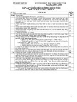
2.3. Digital Shoreline Analysis System
(DSAS)
The Digital Shoreline Analysis System
(DSAS) is a GIS-based system developed by
the United States Geological Survey (USGS).
Two DSAS versions are available: the DSAS
extension of the Environmental System Research Institute (ESRI)’s ArcGIS software
(Thieler et al., 2009), and the DSAS web. The
DSAS software was selected because it runs
faster than the web-based version. DSAS
measures gaps between the shoreline positions
during defined periods of time. This provides
the basic data to calculate the shoreline
changes. The historical trend of these shoreline changes is based on indicators of the
shoreline geometry. The system controls the
following coastline characteristics: historical
coastline dynamics, shoreline change, development and evolution of gulls, cliff retreat and
erosion, shoreline measurement and modeling
(Oyedotun, 2014). In this study, the End Point
Rate (EPR) was chosen the statistical parameters describing the spatial patterns of shoreline
change (Thieler et al., 2009). EPR measures
mangrove shoreline change by dividing the
distance of the mangrove shoreline between
its initial (year 2005) and the most recent position of shoreline (year 2014).
Figure 2 shows the DSAS components and
its operational flow. DSAS components include the baselines (the starting points of all
90
Repeatcoverage
(days)
16
16
16
16
16
16
16
Orbitaltitude
(kilometers)
705
705
705
705
705
705
705
transects), historical shorelines (for the studied periods), DSAS transects (casting from the
baseline and intersect the multiple shoreline
features), measurement points, measurement
distances, and shoreline uncertainty (setup as
a Personal Geodatabase in DSAS). Baseline,
historical shorelines, and shorelines uncertainty are input data provided by the mangrove
cover maps of 2005, 2010, and 2015. The
spacing between transects along the baseline
and the length of transects were defined based
on the mangrove pattern. The distance between two neighboring transects is 100 meters. DSAS transects are 2,000 meters long.
With a coastline of 32 kilometers, the maximum number of DSAS transects is 320. However, the Giao Long and GiaoHai communes
have no mangroves: consequently only 272
DSAS transects were defined. The DSAS operational flow includes 4 steps: (i) Set default
parameters (step 1): Establish transects, shoreline calculations, metadata and log file output
options; (ii) Cast transects (step 2): establish a
transect geodatabase, a casting method by using smoothing distances, flip baseline orientation, and a transect metadata file; (iii) Edit
(step 3):modify the baseline and directly edit
individual transects; (iv) Calculate the change
statistics (step 4): including process data
(choose existing transect layers, select the statistics to be calculated, specify the confidence
Vietnam Journal of Earth Sciences, 39(1), 87-96
intervals, and shoreline intersection thresholds), validate, and extract the outputs (define
measurement locations and the external module XML input table).
Figure 2. Digital Shoreline Analysis System components and operational flows
3. Results
3.1. Reconstruction of mangrove cover
change
Three mangrove cover maps extracted
from LANDSAT satellite images show that
the mangrove area increased faster and faster
during the period 2005-2014. By 2014 mangroves were found in 7 of the 9 coastal communes along the Ba Lat and Day estuaries:
Giao Thien, Giao An, Giao Lac, Giao Xuan
(Ba Lat estuary), Bach Long, Giao Phong, and
Quat Lam (Day estuary). Mangroves increased by 2,487 hectares over a period of 10
years, which corresponds with an average expansion rate of 250 ha yr-1.
In 2005 the mangroves covered 1,387 hectares; by 2010 the figure increased to 2,309
hectares. This corresponds with an increase of
9,212 hectares. During this first period the
mangrove cover changed gradually driven by
agro-aquaculture, afforestation and ecological
succession. CR and BS were the main land
cover types which turned into MA: 380 hectares of CR and 671 hectares of BS were involved. During the same period, MA mainly
changed to 110 hectares of CR and 49 hectares of BS.
Mangrove change during 2010-2014 shows
similar trends as during the previous period.
In 2014 there were 3,874 hectares of mangroves, which corresponds with an increase of
1,565 hectares over 5 years. The changes are
explained by urbanization, agro-aquaculture
and afforestation. 163 hectares of CR and
1,903 hectares of BS were the main land cover types which were transformed in mangroves. Mangroves also changed in CR, BU
and BS (369, 85, and 44 hectares respectively). Figure 3 shows limited changes in mangrove cover in the Day estuary, while their
expansion and defragmentation was most significant in the Xuan Thuy NP and the Ba Lat
estuary.
91
Nguyen An Thinh and Luc Hens/Vietnam Journal of Earth Sciences 39 (2017)
Con Ngan
Con Lu
Con Xanh
Quat Lam
(A) LANDSAT 2005 October 10
Con Ngan
Con Lu
Con Xanh
Quat Lam
(B) LANDSAT 2010 November 9
Con Ngan
Con Lu
Con Xanh
Quat Lam
Mangrove cover
(C) LANDSAT 2014 September 25
Figure 3. LANDSAT satellite images (left) and mangrove cover maps (right) in 2005, 2010, and 2014
3.2. Historical mangrove shoreline change
The mangrove shoreline underwent both
expansion and regression during the period
2005-2010. Figure 4 shows the baselines and
92
the DSAS transects which were used to calculate the shoreline changes. 5 baselines were
established along the Xuan Thuy NP, and the
coasts of Giao Thien, Bach Long, Giao
Vietnam Journal of Earth Sciences, 39(1), 87-96
Phong, and Quat Lam. 272 DSAS transects
have been used to calculate the shoreline dynamics. They are identified using consecutively increasing numbers from left to right. Positive values of the EPR (end point rate) indicate mangrove shoreline expansion towards
the sea (increase), and negative values represent inland movements (degradation).
In 126 transects mangrove shoreline regressionwas observed, while the other 146 transects showed expansion of the mangroves.
During 2005-2014, the regression rate variesbetween 0.02 m yr-1 to 36.77 m yr-1, with
an average of 1.41 m yr-1 (see the maps A, B,
and C in the Figure 3). The rate of increase
ranges between 0.03 to 49.27 m yr-1, with an
average of 1.26 m yr-1 (see the maps B and D
in the Figure 3). This figure is not in conflict
with the overall increase of the mangroves
which is described above. Mangrove shorelines move land inwards: new mangroves are
formed inland as a result of plantation programs; whereas, damaged mangroves are
merely located on tidal alluvial soils close to
the sea which protects the hinterland from impacts of sea waves and storms.
Figure 3. End Point Rate value of historical mangrove shorelines in the Giao Thuy coast during 2005-2014
Differentiating mangroves just using cover
data from LANDSAT satellite images is uncertain because all mangrove patches show a
homogeneous pattern and texture. As shown
in figure 4, using the DSAS transect results
and the derived EPR values one may disti
guish 4 mangrove zones in the study area (see
the figure 4):
- Mangrove zone 1 (along with the coast of
the Giao Thien commune) (“A1” symbol in
the map of mangrove zoning): this zone includes mangroves of the upper Ba Lat estuary.
The 40 transects of this zone are consecutively numbered from 1 to 40. These forests were
lost as a result of intensive aquaculture development (mangrove MA transfer to marshland
93
Nguyen An Thinh and Luc Hens/Vietnam Journal of Earth Sciences 39 (2017)
ML). EPR values range from -1.61 to 0.01 m
yr-1.
- Mangrove zone 2 (Xuan Thuy NP) (A2):
this zone includes the mangroves surrounding
the lower Ba Lat estuary. Their protection status varies: In Con Lu near the core zone of the
Xuan Thuy NP they are strictly protected:
Con Ngan is an ecological restoration area:
other mangroves are part of the beach and
mining areas and are not protected. Aquaculture expanded on the bare tidal soils of the area. The mangroves near Con Xanh were the
subject of natural disasters as storms, flash
floods, salinization, pollution and calamities
from inland industrial areas. The protected
mangrove forests in this vast zone increase
and expand on the bare land faster than in the
three other zones. The ERP values of the 143
DSAS transects (numbered 41 to 183) in this
zone range between 40.01 and 68.75 m yr-1 in
Con Lu, Con Ngan, and Con Xanh, and between 0.01 and 20.01 m yr-1 along the beaches of the Giao An, Giao Lac and Giao Xuan
communes.
- Mangrove zone 3 (Bach Long and Giao
Phong coast) (A3): this zone includes mangroves surrounding the Day estuary. Mangroves are regressing as a result of intensive
agro-aquaculture development and salt production. The ERP values of the 50 DSAS
transects (numbered from 184 to 235) vary
between -36.77 and -19.99 m yr-1, which indicates the regression of the mangrove forest in
this zone.
- Mangrove zone 4 (Quat Lam coast) (A4):
this zone includes the mangroves of the Day
estuary. Tourism develops in this area, while
both agro-aquaculture and industry are less
important and mangroves increase in this
zone. A large area of bare tidal soil outside the
national dike allows the expansion of the forests. The ERP values in the 36 DSAS transects (236 to 272) range between 20 to 40 m
yr-1. This is the second fastest rate of mangrove extension along the coastline in
Giao Thuy.
Figure 4. Mangrove zones of Giao Thuy coast
94
Vietnam Journal of Earth Sciences, 39(1), 87-96
4. Discussion and conclusion
Overall the mangroves in the Giao Thuy
district increased by 2486.96 hectares during
2005-2014. Among the 272 DSAS transects in
this study, 126 showed mangrove shoreline
regression, while the mangrove forests increased in the 146 other transects. The degradation rate is calculated at 1.41 m yr-1, and
the growth rate is 1.26 m yr-1on average. The
dynamic analysis of the DSAS transects using
EPR-values allows defining 4 zones in the
study area. Zones near the Xuan Thuy NP and
along the coast of Quat Lam coast expand
fastest along the coastline in Giao Thuy.
Even though other research also focused
on detecting and monitoring mangrove changes in Nam Dinh province using remote sensed
data (Pham et al., 2016) or based on a combination of DSAS and remote sensing (To and
Thao, 2008), this is the first study using
DSAS for the purpose of both mangrove
shoreline change analysis and mangrove zoning. This is a methodological improvement
because proved very difficult to clarify different mangrove zones by using only mangrove
zone type detected on separate satellite images. The combination with DSAS statistics allows identifying indicators that discriminate
between different mangrove zones. DSAS allows examining historical shorelines, which is
an advantage as compared with the traditional
ground survey techniques (Thieler et al.,
2009). This study combines DSAS and remote
sensing to describe historical mangrove shoreline changes and mangrove zoning. The results show that this combination is a practical
application for decision-making on coastal
management.
The main limitation of this study is in
choosing the DSAS statistical change parameters defining the mangrove zones. Five main
measures among which the Net Shoreline
Movement (NSM), the Shoreline Change Envelope (SCE), the End Point Rate (EPR), the
Linear Regression Rate (LRR) and the
Weighted Linear Regression Rate (WLR) can
be used. In this study, only the End Point Rate
(EPR) was calculated. However, because of
the strong correlation between these values
(Thieler et al., 2009), the EPR is a sensitive
measure of mangrove change. It is easy to understand as it calculates the shoreline position
over different time periods.
Socio-economic development, but also environmental factors as global climate change
explain the changes and make further studies
imperative. Not only the rate of change should
be quantified, but also the drivers of the
changes should be identified in more detail.
Historical mangrove shoreline change should
be considered as a parameter to monitor
changes in coastal environments as indicators
of global warming, climate change, storm effects, sea level change, pollution, and sedimentation rates.
References
Alongi, D.M., 2008. Mangrove forests: Resilience, protection from tsunamis, and responses to global climate change. Estuarine, Coastal and Shelf Science,
76(1), 1-13.
Cohen, M.C.L., Lara R.J., 2003. Temporal changes of
mangrove vegetation boundaries in Amazonia: Application of GIS and remote sensing techniques.
Wetland Ecology Management 11, 223-231.
Ellison, J., 2000. How South Pacific mangroves may
respond to predicted climate change and sea level
rise. In: Gillespie A. and Burns W. (Eds.). Climate
change in the South Pacific: Impacts and responses
in Australia, New Zealand, and small islands states.
Dordrecht, Netherlands: Kluwer Academic Publishers (Chapter 15), 289-301.
Hegde, A.V., Akshaya B.J., 2015. Shoreline transformation study of Karnataka Coast: Geospatial Approach. Aquatic Procedia 4, 151-156.
Lewis, R.R., 2005. Ecological engineering for successful
management and restoration of mangrove forests.
Ecological Engineering, 24(4SI), 403-418.
Moussaid, J., Fora A.A., Zourarah B., Maanan M.,
Maanan M., 2015. Using automatic computation to
95
Nguyen An Thinh and Luc Hens/Vietnam Journal of Earth Sciences 39 (2017)
analyze the rate of shoreline change on the Kenitra
coast, Morocco.Ocean Engineering, 102(1), 71-77.
Nguyen Hai Hoa, McAlpine C., Pullar D., Leisz S.J.,
Galina G., 2015. Drivers of coastal shoreline
change: case study of Hon Dat coast, Kien Giang,
Vietnam. Environmental Management, 55(5),
1093-1108.
Oyedotun, T.D.T., 2014. Shoreline Geometry: DSAS as
a tool for historical trend analysis. Geomorphological Techniques, Chapter 3(2.2), British Society for
Geomorphology, 1-12.
Pham Quang Son , Nguyen Duc Anh, 2016. Evolution of
the coastal zone in Hai Hau district (Nam Dinh province) and nearest region over the last 100 years
based on analysis topographic maps and multitemporal remote sensing data. Vietnam Journal
of Earth Sciences, 38(1), 118-130 (in Vietnamese).
Rebelo, L.M., Finlayson C.M., Nagabhatla N., 2009.
Remote sensing and GIS for wetland inventory,
mapping and change analysis. Environmental Management, 90, 2144-2153.
Sathirathai, S., Barbier E.B., 2001. Valuing mangrove
conservation in southern Thailand. Contemporary
96
Economic Policy, 19(2), 109-122.
Sheik, M., Chandrasekar, 2011. A shoreline change
analysis along the coast between Kanyakumari and
Tuticorin, India, using digital shoreline analysis system. Geo-spatial Information Science, 14(4), 282.
Thieler, E.R., Himmelstoss E.A., Zichichi J.L., Ergul A.,
2009. Digital Shoreline Analysis System (DSAS)
version 4.0 - An ArcGIS extension for calculating
shoreline change.U.S. Geological Survey Open-File
Report 2008-1278.
Dang Van To, Phan Thi Phuong Thao, 2008. A shoreline
analysis using DSAS in Nam Dinh coastal area.
GeoInformatics, 4(1), 37-42.
Tran Thi V., Xuan A Tien Thi., Phan Nguyen Hong,
Dahdouh-Guebas F., Koedam N. , 2014. Application
of remote sensing and GIS for detection of longterm mangrove shoreline changes in Mui Ca Mau,
Vietnam. Biogeosciences ,11, 3781-3795.
Vu Van Loi, 2016. Sedimentary facies and engineering
geological characteristics of Holocene deposits in
the coastal area of Tien Lang district, Hai Phong
city. Vietnam Journal of Earth Sciences, 38(1),
108-117.