Projection of saline intrusion into groundwater in the context of climate change in the coastal zone of Ha Tinh province
Bạn đang xem bản rút gọn của tài liệu. Xem và tải ngay bản đầy đủ của tài liệu tại đây (1.6 MB, 7 trang )
Environmental Sciences | Climatology
Doi: 10.31276/VJSTE.60(4).82-88
Projection of saline intrusion into
groundwater in the context of climate change
in the coastal zone of Ha Tinh province
Van Dai Nguyen*, Tien Anh Do, Kim Tuyen Nguyen
Vietnam Institute of Meteorology, Hydrology and Climate Change
Received 30 June 2018; accepted 19 September 2018
Abstract:
Introduction
In addition to surface water, groundwater is an
essential source of water for agriculture, industry, and
living in Ha Tinh province (central Vietnam). However,
overexploitation and unreasonable use of groundwater
has put this resource at risk of endangerment and
pollution. In the coastal areas especially, the impact of
climate change and the rise in sea-level has increased
the risk of salt-water intrusion into groundwater. In
this study, the groundwater system model (GSM) is
applied to simulate the intrusion of saline water in
different climate change scenarios in the coastal area
of Ha Tinh province. The result reveals that saline
intrusion into groundwater is becoming more complex
and is a rising trend in climate change scenarios
RCP4.5 and RCP8.5.
Salt-water intrusion into surface water and groundwater
is a frequent problem in the coastal areas of Ha Tinh
province, as well as in other provinces and cities. With the
current socio-economic growth rate, water demand from
various sectors is increasing dramatically; on the other
hand, with the impact of climate change, surface water as
a resource is diminishing and pollution levels are rising.
This, in turn, depletes the available store of surface water
that sectors depend on. In this context, groundwater would
be an effective solution to provide for the needs of socioeconomic development, especially where exploitation
of surface water is no longer possible. However, as with
surface water, groundwater also faces the risk of seawater
intrusion; hence, if there are no solutions to reducing
saltwater infiltration, or rationally using and supplementing
fresh water for groundwater, coastal resources will diminish
and fail to supply the needs of socio-economic development.
In this study, the GSM is applied to simulate groundwater
level and assess saline intrusion in climate change scenarios
over extended periods of time in the coastal areas of Ha
Tinh (including seven coastal districts, two towns, and one
city: Nghi Xuan, Duc Tho, Can Loc, Loc Ha, Thach Ha,
Cam Xuyen, and Ky Anh districts; the city of Ha Tinh; and
the towns of Ky Anh, Hong Linh). The primary objective
of this study is to assess the impact of climate change on
coastal groundwater resources.
Keywords: climate change, coastal, groundwater, Ha
Tinh, saline intrusion.
Classification number: 5.2
Method and data
Method
The GSM model was applied to simulate the groundwater
resource for the coastal area of Ha Tinh province:
The GSM is a model that integrates the MODFLOW
[1] groundwater flow model and the MT3DMS [2] waterquality model to simulate groundwater flow and quality.
In the MODFLOW model, the three-dimensional
*Corresponding author: Email:
82
Vietnam Journal of Science,
Technology and Engineering
December 2018 • Vol.60 Number 4
study is to assess the impact of climate change on coastal groundwater
The partial differential
describing the
fate and
transporting
of and transporting of
Theequation
partial differential
equation
describing
the fate
resources.
contaminants of species
k in 3D, of
transient
flow systems
can beflow systems can be
contaminants
speciesgroundwater
k in 3D, transient
groundwater
written as follows: written as follows:
Method and data
Method
(C k )
(Ck()C k ) k (Ck k )
D) ij qs Cs
Rn (vi C k ) qs Csk(2)
Dij
(v C
The GSM model was applied to simulate the groundwater resource
for
the
t x x i the
| Climatology
transporting
The partial differential
fate
and
of Rn
Environmental
Sciences
t
xi equation
x j describing
x
i
i
j
xi
coastal area of Ha Tinh province
(2)
contaminants of species k in 3D, transient groundwater flow systems can be
The GSM is a model that integrates the MODFLOWwritten
[1]Where:
groundwater
Where:
as follows:
flow model and the MT3DMS [2] water-quality model to simulate groundwater
of
sub-surfaceof medium,
consideredmedium,
to be considered to be
: the porosity
the
the sub-surface
: (the
(C k ) the
relationship
C k ) porosity
flow and movement
quality.
k
of a groundwater level of a constant
density
dimensionless.
Dij
vi =(qvii C/θ.
) qs Csk Rn
(2)
dimensionless.
xi
xi
-3
k x j
-3
In through
the MODFLOW
the three-dimensional
movement
ofdissolved
a t
porous model,
earth material
may be described
the
species
concentration
of
k,
ML
Ck:by
:
dissolved
concentration
of
species
k,
ML
C
.
.
of the
qs: volumetric flow rate per unit of the volume
groundwater
level of partial
a constant
density through
porous earth materialt:maytime,
be T.
following
differential
equation:
t: representing
time, T.
Where:
aquifer,
fluid sources (positive) and sinks
described by the following partial differential equation:
coordinate
axis, L. coordinate axis, L.
xi,j: distance along the
: distance
along the
relevant Cartesian
xi,jrelevant
-1 Cartesian
. coefficient
porosity(negative),
ofdispersion
the Tsub-surface
medium,
to be
2 considered
-1
h
h
h
h : Dijthe
:
hydrodynamic
tensor,
L
T
.
D
:
hydrodynamic
dispersion
coefficient
tensor, L2T-1.
ij
K xx K yy K zz W Sdimensionless.
(1)(1)
-1
s
k
seepage or linear
waterorvelocity,
LT ;water
this
is related
to-1;the
x
x y
y z
z
t
: pore
seepage
linear
velocity,
this is related to the
k v i:
-3 pore
Cs v: iconcentration
of
the
source
or sink
flux LT
for
species
:
dissolved
concentration
of
species
k,
ML
C
.
qthe
.
specific discharge or specific
Darcy flux
by means
of the relationship
vi =
discharge
or
Darcy
flux
by
means
of
v i = qi / .
i / relationship
Where:
-3
where:
t:
time, T.
k, ML
qs: volumetric
flowqs.: rate
per unitflow
of the
volumetric
rate volume
per unitof ofthetheaquifer,
volume of the aquifer,
xx,
along the relevant Cartesian coordinate axis,-1L.
- Kxx, Kyy, Kzz: are values of hydraulic conductivity along the
and zfluid
i,j: y,distance
-1
representing
(positive)
andsources
sinks (negative),
T . sinks
representing
fluid
(positive)
-3 -1 (negative), T .
, Kassumed
: are values
of hydraulic conductivity
along sources
- Kxx, Kyyare
2 -1 and
zz
Rk n: chemical
coefficientreaction
tensor, Lterm,
T . ML T -3.
coordinate axes, which
to be parallel to the major axes D
ofij:hydraulic
khydrodynamic dispersion
-3
C : concentration
of the
or sink flux
forsource
species k, MLflux
Cs :source
of the
. for species k, ML .
the(L/T).
x, y, and z coordinate axes, which are assumed
to be or linear
conductivity
vi: sseepage
poreconcentration
water -3velocity,
LT-1; thisor-3issink
related
to the
-1
-1
reaction
ML of
T reaction
Rn : chemical
term, ML
Rterm,
parallel to the major axes of hydraulic conductivity
(L/T).
.
left-hand
n : chemical
specific
discharge
or Darcy
flux
by
means
the
v2i =T
qi. / be. expanded into
- h: is the potentiometric head (L).
The
side
ofrelationship
Equation
can
∑
volumetric
flowofterms:
rate left-hand
per 2 unit
the
volume
ofbe
the
aquifer,
s:The
left-hand side
Equation
canside
beofof
expanded
into
two
terms:
The
Equation
2 can
expanded
into two terms:
two
h: is the flux
potentiometric
head
(L). sources qand/or
- W: is a -volumetric
per unit volume
representing
sinks
representing
andk sinks (negative),
T-1.
of water, with W < 0.0 for flow out of the groundwater system,
and Wk > 0.0fluid
for sources (positive)
k
k
k
k
k
-3
(
C
)
C
C
(C
) qC'k,CML
for
C
k
k
- W: is
Cs : concentration of the source
or sink
Cflux
species
flow into the system
(T-1a).volumetric flux per unit volume representing
C k .
q(3)
' s C k (3)
(3)
t
-3t -1 t t t st
t
t
-1 forR flow
sources
and/or
sinks
of
water,
with
W
<
0.0
out
chemical
reaction
term,
ML
T
:
.
- S: is the specific storage capacity of the porous material (L ). n
of the groundwater system, and W > 0.0 for flow into
the
-1
- t: is time (T). -1
q's side
is the
rate
of change
transient
storage (unit,
). storage (unit, T-1).
Where:
q's 2 canin
isbe
the
rate
change
transient
groundwater
The left-hand
ofWhere:
Equation
expanded
into two
is
the ofgroundwater
rate
ofin terms:
change
in Ttransient
where:
t
system (T ).
t
This equation describes water-level dynamics in heterogeneous and
(C k )
C k
C k -1
Ck
(3)
groundwater
storage
(unit,
T ).q's C k
anisotropic environments.
- S: is the specific storage capacity of the porous The
material
chemical
reaction
term
in
equation
2
can
be used
to include
thebeeffect
t
t
t
t
The
chemical
reaction
term
in equation
2 can
used to include the effect
-1
). MT3DMS water quality model, transporting of
(L the
With
solutions
a
generalin biochemical
and chemical
geochemical
reactions
onintheequation
fate reactions
and2transport
of fate and transport of
of
general
biochemical
and
geochemical
on
the
The
reaction
term
can
be
-1 used to
porous environment is a complex chemical and physical process.
Two
q's basicisConsidering
Where:
the
rate
of
change
in
transient
groundwater
storage
(unit,
T
).
contaminants.
only
two
basic
types
of
chemical
reactions,
that
is,
contaminants.
Considering
only
two
basic
types
of
chemical
reactions, that is,
- t:theis process
time (T).
include the effect of general biochemical and geochemical
t
components of
are (i) the transporting of hydrodynamics and (ii)
aqueous-solid surfaceaqueous-solid
reactions (sorption)
and first-order
rate and
reactions,
the rate reactions, the
surface
reactions
(sorption)
first-order
diffusion of ions and particles are dissolved in water from the high concentration
reactions
on the asfate
and transport of contaminants.
reaction
can be expressed
follows:
This equation describes water-level chemical
dynamics
in term
chemical
reaction term
can be expressed as follows:
to the low concentration. When contaminated water flows through The
the porous
chemical reaction
term in only
equation
2basic
can be
usedof
to chemical
include thereactions,
effect
Considering
two
types
that
k
heterogeneous
and anisotropic
k
environment,
it mixes with uninfected
water by environments.
means of mechanical
dispersion
Csurface
C
of general
biochemicalis,and
geochemical
reactions
and
transport
of
k on the k fate
k and first-order
k
aqueous-solid
reactions
(sorption)
1C
R
n2 bC b
1C 2 bC (4)
(4)
Rn b t types
that dilutes it and reduces its concentration. Molecular diffusion
and mechanical
contaminants.
Considering
only two basic
of chemical
is,
tterm canthat
Withbe the
MT3DMS
water quality
model,
transporting
rate reactions,
the chemical
reaction reactions,
be expressed
dispersion cannot
separated
in an underground
stream and
both processes
are
aqueous-solid
surface reactions (sorption) and first-order rate reactions, the
in a porous
environment is a complex
chemical
referred tosolutions
as hydrodynamic
dispersion.
asWhere:
follows:
Where:
chemical
and physical process. Two basic components
of thereaction
processterm can be expressed as follows: -1
medium,
ML
ρb: bulk density of theρbsub-surface
: bulk density
of the sub-surface
medium, ML-1.
.
C k
-1
are (i) the transporting of2 hydrodynamics and (ii) Cdiffusion
k
k
k
k
: concentration
ofRC
species
subsurface
solids,
MM
b k sorbed
1Conof
the
species
k sorbed
on the
subsurface
solids,
.(4)
(4) MM-1.
n :concentration
2 bC
-1
t
of ions and particles are dissolved in water from the
high
-1
for the dissolved
phase,
: first-order
reaction rate
for Tthe. dissolved phase, T .
1 rate
1 : first-order reaction
concentration to the low concentration. When
contaminated
for the sorbed
(solid)
phase,
T-1.
2 : first-order reaction
Where:
: first-order
reaction
rate for
the sorbed
(solid) phase, T-1.
2 rate
water flows through the porous environment, it mixes with where:
ρb: bulk density of the sub-surface medium, ML-1.
uninfected water by means of mechanical dispersion
that
of the sub-surface medium, ML-1.
ρb: bulkkdensity
sorbed on the subsurface solids, MM-1.
C k : concentration of species
dilutes it and reduces its concentration. Molecular: diffusion
: concentration
of species
Ckrate
for the dissolved
phase, T-1k. sorbed on the subsurface
1 first-order reaction
3
and mechanical dispersion cannot be separated
in an solids, MM-1.
-13
2 : first-order reaction rate for the sorbed (solid) phase, T .
underground stream and both processes are referred
to as
λ1: first-order reaction rate for the dissolved phase, T-1.
hydrodynamic dispersion.
λ2: first-order reaction rate for the sorbed (solid) phase,
The partial differential equation describing the fate and
The partial differential equation describing the fate and transporting of
T-1.
3
transporting
of speciesflow
k insystems
3D, transient
contaminants
of species of
k incontaminants
3D, transient groundwater
can be
Substituting equations 3 and 4 into equation 2 and
flow systems can be written as follows:
written asgroundwater
follows:
omitting
theequations
species
in order
simplify
the
Substituting
3 andindex
4 into equation
2 andtoomitting
the species
(C k )
(C k )
D
(v C k ) qs Csk Rn
(2)(2) index
presentation,
Equation
2 can be rearranged
andberewritten
in order to simplify
the presentation,
Equation 2 can
rearranged as:
and
t
xi ij x j xi i
Where:
rewritten as:
where:
: the
porosity of the sub-surface medium, considered to be
dimensionless.θ: the porosity of the sub-surface medium, considered to
Ck: be
dissolved
concentration of species k, ML-3.
dimensionless.
t: time, kT.
concentration
of species
k,L.ML-3.
C : dissolved
xi,j: distance
along the relevant
Cartesian coordinate
axis,
2 -1
Dij: hydrodynamic
t: time, T.dispersion coefficient tensor, L T .
vi: seepage or linear pore water velocity, LT-1; this is related to the
along
the relevant
Cartesian
axis,
xi,j: distance
= qi / .
specific discharge
or Darcy flux
by means
of the relationship
vi coordinate
L.
qs: volumetric flow rate per unit of the volume of the aquifer,
representing fluid
(positive) and
sinks (negative),
T-1. tensor, L2T-1.
hydrodynamic
dispersion
coefficient
Dij: sources
-3
k
Cs : concentration of the source or sink flux for species k, ML .
-3
-1
linear
water velocity, LT-1; this is
vi: seepage
reaction or
term,
ML Tpore
.
Rn : chemical
related to the specific discharge or Darcy flux by means of
The left-hand side of Equation 2 can be expanded into two terms:
(C k )
C k
C k
Ck
q' s C k
t
t
t
t
Where: q's
(3)
C
C
C
b
Dij (viC ) qsCs q's C 1C 2 bC
t
t xi x j xi
Equation
5 is 5a mass
is, the change
Equation
is abalance
mass statement,
balancethat
statement,
thatin the
is, mass
the
storage (both dissolved and sorbed phases) at any given time is equal to the
change
in
the
mass
storage
(both
dissolved
and
sorbed
difference between the mass inflow and outflow due to dispersion, advection,
phases)and
at any
given
time is equal to the difference between
sink/source,
chemical
reactions.
theLocal
mass
inflow isand
duethetovarious
dispersion,
advection,
equilibrium
oftenoutflow
assumed for
sorption processes
(i.e.,
sink/source,
andfast
chemical
sorption
is sufficiently
relative toreactions.
the transport time scale). When the local
equilibrium assumption is invoked, it is customary to express equation 5 in the
Local
following
form: equilibrium is often assumed for the various
sorption processes (i.e., sorption is sufficiently fast relative
C
C scale). When the local equilibrium
to the
R transport
Dij time
(viC ) qsCs q's C 1C 2 bC
(6)
t
xi
x j xi
Where: R is referred to as the retardation factor, which is a dimensionless factor
defined as:
is the rate of change in transient groundwater storage (unit, T-1).
b C Vietnam Journal of Science,
t
R 1 4
December 2018 • Vol.60 Number
C Technology and Engineering
The chemical reaction term in equation 2 can be used to include the effect
of general biochemical and geochemical reactions on the fate and transport of
(5)
(5)
83(7)
When the local equilibrium assumption is not appropriate, sorption
processes are typically represented through a first-order kinetic mass transfer
rewritten as:
C
C
C
b
Dij (viC ) qsCs q's C 1C 2 bC
t
t xi x j xi
(5)
Equation 5 is a mass balance statement, that is, the change in the mass
storage (both dissolved and sorbed phases) at any given time is equal to the
Environmental Sciences | Climatology
difference between the mass inflow and outflow due to dispersion, advection,
sink/source, and chemical reactions.
Local equilibrium is often assumed for the various sorption processes (i.e.,
sorption
is sufficiently
fast relative
to customary
the transport time
scale). When
the local
assumption
is invoked,
it is
to express
equation
5
equilibrium
assumption
is
invoked,
it
is
customary
to
express
equation
5
in
the
in the following form:
following form:
R
C
C
D
(v C ) qsCs q's C 1C 2 bC
t xi ij x j xi i
(6)
(6)
Where: R is referred to as the retardation factor, which is a dimensionless factor
where:
defined
as: R is referred to as the retardation factor, which is a
dimensionless factor defined as:
C
R 1 b
C
(7)
ρb ∂ C
R = 1the
+ local
(7)
When
q ∂ Cequilibrium assumption is not appropriate, sorption
processes are typically represented through a first-order kinetic mass transfer
equation, as discussed in the section on chemical reactions.
when the local equilibrium assumption is not appropriate,
Data
sorption processes are typically represented through a firstInputkinetic
data for the
GSMtransfer
include: equation, as discussed in the
order
mass
- Hydrometeorological
data: meteorological and hydrographic data up to
section
on chemical reactions.
2014 from the project “Technical consultancy on the hydrological/hydraulic
Data
model of
the Rao Cai river basin and the drainage model in the city of Ha Tinh,
Ha Tinh province” were also part of the project “Integrated water resource
Input data for the GSM include:
management and urban development in Ha Tinh province”, conducted by the
Vietnam- Academy
for Water Resources [3].
Additional
data up to 2016 and
were
Hydrometeorological
data:
meteorological
collected
from the Hydrometeorological
Centre
the National
Center of
hydrographic
data up to 2014Data
from
theofproject
“Technical
Meteorology
and on
Hydrology
(now the Meteorological
and of
Hydrological
consultancy
the hydrological/hydraulic
model
the Rao
Administration).
Cai river basin and the drainage model in the city of Ha Tinh,
Land-use
data: land-use
status part
data of
forthe
Ha project
Tinh from
2015 were
Ha- Tinh
province”
were also
“Integrated
collected from Center for Land Assessment under Center for Land Survey and
water resource management and urban development in
Planning under General Department of Land Administration.
Ha Tinh province”, conducted by the Vietnam Academy
for Water Resources [3]. Additional data up to 2016 were
collected from the Hydrometeorological Data Centre of the
4
National Center of Meteorology
and Hydrology (now the
Meteorological and Hydrological Administration).
- Land-use data: land-use status data for Ha Tinh from
2015 were collected from Center for Land Assessment
under Center for Land Survey and Planning under General
Department of Land Administration.
- Stratigraphic data: the 2014 1:200,000-scale hydrogeological map of Ha Tinh province was sourced from
the National Center for Water Resource Planning and
Investigation.
- The stratigraphic data on hydro-geological boreholes
were inherited from the project “Planning, exploitation,
utilization, and protection of water resources in Ha Tinh
province up to 2020”, conducted by the 2F Division for
Water Resources Planning and Investigation of the Ministry
of Natural Resources and Environment in 2011 [4].
- Survey data: survey data were collected by means
of interviews with local people using pre-designed table
templates, and by means of direct water sampling. The
scope and subjects of the survey were the current status
of water use in 330 households and 20 organisations in 10
coastal districts/cities/towns of Ha Tinh province.
- Climate-change scenarios: climate-change in Ha Tinh
84
Vietnam Journal of Science,
Technology and Engineering
province was examined in terms of two scenarios, RCP4.5
and RCP8.5, for temperature (Table 1), precipitation (Table
2) and sea level rise (Table 3) extraction from climate
change and sea-level rise scenarios for Vietnam, which were
updated by Ministry of Natural Resources and Environment
in 2016 [5].
Table 1. Changes in temperature (oC) compared to the period
1986-2005 in terms of different climate change scenarios in Ha
Tinh province.
RCP4.5
RCP8.5
Temperature
2016-2035 2046-2065
2080-2099 2016-2035 2046-2065
2080-2099
Annual
0.6
(0.3÷1.0)
1.5
(1.0÷2.1)
2.0
(1.4÷2.9)
0.9
(0.6÷1.3)
1.9
(1.3÷2.8)
3.5
(2.8÷4.8)
Winter
0.6
(0.3÷1.0)
1.3
(0.7÷1.8)
1.6
(1.0÷2.1)
0.9
(0.6÷1.2)
1.7
(1.2÷2.4)
2.8
(2.0÷3.7)
Spring
0.6
(0.1÷1.2)
1.3
(0.7÷1.9)
2.0
(1.2÷2.9)
0.9
(0.5÷1.3)
1.8
(0.9÷2.8)
3.2
(2.0÷4.5)
Summer
0.8
(0.4÷1.3)
1.9
(1.2÷3.0)
2.6
(1.8÷3.6)
1.0
(0.5÷1.5)
2.3
(1.4÷3.6)
4.1
(3.2÷5.7)
Autumn
0.6
(0.3÷1.1)
1.5
(1.0÷2.2)
2.0
(1.2÷2.9)
0.8
(0.4÷1.4)
2.0
(1.3÷3.0)
3.6
(2.7÷5.0)
Source: Vietnam Institute of Meteorology, Hydrology and Climate
Change (IMHEN).
Table 2. Changes in rainfall (%) relative to the period 1986-2005
in terms of climate change scenarios in Ha Tinh province.
RCP4.5
Rainfall
RCP8.5
2016-2035 2046-2065
2080-2099 2016-2035
2046-2065
2080-2099
Annual
11.3
(6.0÷16.6)
16.3
(8.5÷24.4)
13.0
(3.4÷22.6)
12.9
(6.8÷18.9)
14.1
(8.9÷19.0)
17.4
(10.6÷24.4)
Winter
12.0
(4.1÷19.5)
21.0
12.8
(11.4÷30.4) (5.4÷20.0)
3.5
(-2.1÷9.2)
13.0
(1.6÷24.4)
19.8
(6.5÷33.2)
Spring
2.8
(-3.7÷9.2)
14.5
(4.3÷23.9)
9.4
-4.2
5.0
(-1.8÷20.5) (-14.4÷5.8) (-3.5÷13.0)
16.1
(2.1÷30.5)
Summer
21.1
9.1
4.8
40.6
(-3.7÷44.7) (-2.1÷20.3) (-5.7÷16.1) (5.0÷70.7)
Autumn
9.9
(3.8÷16.1)
19.0
(5.2÷31.6)
17.6
(3.8÷30.3)
18.6
(-6.5÷43.4)
8.2
15.1
(-0.1÷15.8) (6.6÷23.4)
22.2
(3.0÷41.8)
17.6
(8.2÷27.0)
Source: IMHEN.
Table 3. Sea-level rise scenarios for the coastal areas of Ha Tinh
province (cm).
Scenarios
Timeline of the 21st century
2030
2040
2050
2060
2070
2080
2090
2100
RCP4.5
13
17
(8÷18) (10÷24)
22
(13÷31)
27
(16÷39)
33
39
(20÷47) (24÷56)
46
53
(28÷65) (32÷75)
RCP8.5
13
18
(9÷18) (12÷26)
25
(17÷35)
32
(22÷45)
40
50
(28÷57) (34÷71)
60
72
(41÷85) (49÷102)
Source: IMHEN.
December 2018 • Vol.60 Number 4
Environmental Sciences | Climatology
- Boundary conditions:
+ The sea boundary is
approximately 143 km, from
the Lam river mouth to the end
of Ky Anh town, next to Quang
Binh province.
+ The river boundary
comprises four major rivers, the
Lam, Ha, Lui, Quyen, and their
major branches (Fig. 2).
+ The groundwater
restoration
boundary
was
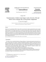
Fig. 1. Computational domain and computational
the Fig. the
2. Sea and river boundaries in the research area.
calculatedgrid
by ofsubtracting
research area.
evaporation boundary from the Fig. 2. Sea and river boundaries in the
precipitation boundary in the research area.
corresponding exposure area of
Holocene layer
Results and discussion
geological layers in the research
Pleistocene layer
The GSM model constructed for the coastal
area
of Ha
area (Fig.
3 and
Table 4).
Neogen, Triat, OrdovicTinh province
Silur layer
- The computational domain includes the coastal districts
of Nghi Xuan, Duc Tho, Can Loc, Loc Ha, Thach Ha, Cam
Xuyen, and Ky Anh; the city of Ha Tinh; and the towns of
Ky Anh, Hong Linh (Fig. 1).
- The computational grid includes 563,060 grid points,
including 294,865 computational points. Grid cell size is
200 m x 200 m.
Fig. 3. Exposure
of geological
in the research
area.
Fig. area
3. Exposure
arealayers
of geological
layers in
- Boundary conditions:
the research area.
+ The sea boundary is approximately 143 km, from the
- A 3-year period was used to warm up the model to
Lam river mouth to the end of Ky Anh town,
next4.toClassification
Quang
Table
of the
restoration
area in the coastal
reduce
thegroundwater
effect of initial
conditions.
Binh province.
area of Ha Tinh province.
- Computational time step: daily.
+ The river boundary comprises four major rivers, the
Restoration rate
No. 2). Restoration
area
Calibration
and validation
Lam, Ha, Lui, Quyen, and their major branches (Fig.
from rainfall (%)
+ The groundwater restoration boundary was1calculated
HoloceneFor model calibration, this
35 research employs monitoring
by subtracting the evaporation boundary from the data from January 2014 to December 2016 from four
2
Pleistocene
35
precipitation boundary in the corresponding exposure area groundwater level stations within research area (Table 5).
3 Table 4).
Neogen, Triat, Ordovic-Silur
15
of geological layers in the research area (Fig. 3 and
Table 4. Classification of the groundwater restoration area in
the coastal area of Ha Tinh province.
Table 5. Differences between the simulated water level and the
water level measured at groundwater level monitoring wells in
the research area.7
No.
Station
Mean absolute
difference
Root mean square
deviation
Maximum
difference (m)
No.
Restoration area
Restoration rate
from rainfall (%)
1
QT2a-HT_0
0.05
0.004
0.15
1
Holocene
35
2
QT5a-HT_0
0.13
0.023
0.32
2
Pleistocene
35
3
QT6-HT_0
0.18
0.057
0.91
3
Neogen, Triat, Ordovic-Silur
15
4
QT6b-HT_0
0.13
0.039
0.81
December 2018 • Vol.60 Number 4
Vietnam Journal of Science,
Technology and Engineering
85
January 2014 to December 2016from four groundwater level stations within
research area (Table 5).
Table 5. Difference s between the simulated water level and the water level
measured at groundwater level monitoring wells in the research area
MeanSciences
absolute Root
mean
Maximum
| Climatology
Environmental
No.
Station
difference
square deviation difference (m)
1
QT2a-HT_0
0.05
0.004
0.15
QT5a-HT_0
0.023
0.32
The
results of0.13
the model calibration
and validation
show
that
the
model parameters
are 0.057
reliable and can0.91
be applied
3
QT6 -HT_0
0.18
to
research
on
groundwater
in
the
coastal
area
of
4
QT6b-HT_0 0.13
0.039
0.81Ha Tinh.
change of rainfall and a sea level rise of 0.09 m. By 2030,
in terms of scenarios RCP4.5 and RCP8.5, the storage tends
to decrease relative to the current situation. In that year, the
level of salinity intrusion tends to decrease in all the months
Salt-water
reserve
terms and
of validation
the climate
change
The
results of the
model in
calibration
show that
the model
of the year in terms of both RCP4.5 and RCP8.5 scenarios,
scenarios
parameters
are reliableand can be applied to research on groundwater in the
with the largest decrease occurring in August. This change
coastal area of Ha Tinh.
The results of calculating the salt-water storage in the is primarily due to a change in rainfall by 2030, which is
Salt-water
reserve
in terms oflayers
the climate
change
scenarios
Holocene
and
Pleistocene
in 2020
and
2030 in terms
quite similar for both RCP4.5 and RCP8.5 scenarios and the
The results RCP4.5
of calculating
salt-water
storage in tothethe
Holocene
of scenarios
and the
RCP8.5
compared
currentand
scenario of a 0.13 m rise in sea level.
Pleistocene
and 2030
of scenarios
RCP4.5 andinRCP8.5
situationlayers
(thein 2020
average
of in
theterms
period
1986-2005)
the
compared to the current sit
uation (the average of the period 1986-2005) in the
The magnitude of saline intrusion in 2020 and 2030
coastal area of Ha Tinh province are shown in Figs. 4A , 4B.
coastal area of Ha Tinh province are shown in Fig. 4A and Fig. 4B .
is less than that of the (current) baseline period due to a
704
Current status (1986-2005)
RCP4.5 (2020)
RCP8.5 (2020)
significant increase in rainfall in these years.
2
702
Volumn (10 6 m3)
700
698
696
694
692
690
688
686
684
I
II
III
IV
V
VI
(A)
VII
VIII
IX
X
XI
XII
The results of calculating salt-water storage in the
Holocene and Pleistocene layers for the periods 2016-2035,
2046-2065, and 2080-2099 in terms of the RCP4.5 and
RCP8.5 scenarios compared to the current situation in the
thencoastal
it increases
at theprovince
end of theare
century
(2080
With 5B.
scenario
areagradually
of Ha Tinh
shown
in-2099).
Figs. 5A,
RCP8.5, in the early years of the 21st century (2016-2035) groundwatersalinity
shows
trends
of salinity
intrusion
into
intrusionFigure
increase5s in
July, the
August,
September
, November,
and December
compared
to the current
s inarethe
remaining
months.
groundwater
in the situation,
researchand
area,decrease
which
very
complex.
st
However,
in
the
last
years
of
the
21
century
(2080-2099),
saline
st intrusion into
With scenario RCP4.5, in the early years of the 21 century
groundwatertends to increase sharply in comparison with that ofall months of
(2016-2035) the level of salinity intrusion tends to decrease;
the year.
704
Current status (1986-2005)
702
RCP8.5 (2030)
Period 2046-2065
706
8
Period 2080-2099
704
Volumn (10 6 m3)
700
Volumn (10 6 m3)
RCP4.5 (2030)
698
696
694
692
702
700
698
696
694
692
690
690
688
I
II
III
IV
V
VI
VII
VIII
IX
X
XI
XII
I
II
III
IV
V
VI
VII
VIII
IX
X
XI
XII
(A)
(B)
Fig. 4. Salt-water storage diagrams in the Holocene and
Fig.
4. Salt -water
storage
the Holocene
layers
Pleistocene
layers
in diagrams
2020 (A)inand
2030 (B)and
in Pleistocene
the research
inarea
2020according
(A) and 2030
( B ) in the
research
according to scenarios
to scenarios
RCP4.5
andarea
RCP8.5.
RCP4.5 and RCP8.5 .
706
Current status (1986-2005)
Period 2016-2035
Period 2046-2065
Period 2080-2099
Volumn (10 6 m3)
704
The
in Fig.
show4 that
groundwater
salinity in thesalinity
research area
Theresults
results
in 4Fig.
show
that groundwater
in in 702
2020 in terms of scenarios RCP4.5 and RCP8.5 tends to decrease compared with 700
the research area in 2020 in terms of scenarios RCP4.5
the current situation. By 2020, the level of salinity intrusion tends to decrease in
698
RCP8.5
decrease
compared
with
the current
alland
months
of thetends
year in to
both
the RCP4.5
and RCP8.5
scenarios.
For both
situation.
By 2020,
theoccurs
levelinofJuly,
salinity
to for 696
scenarios,
the largest
decrease
and theintrusion
smallest intends
January
decrease
all months
the year
in both the occurs
RCP4.5
RCP4.5
, and in
in December
for of
RCP8.5.
This phenomenon
dueand
to the 694
hypothesis
the problem
claims
thatscenarios,
the amountthe
of largest
groundwater
extraction 692
RCP8.5 ofscenarios.
For
both
decrease
remains
unchanged
to smallest
the currentinsituation
; thisfor
change
may primarily
I
II
III
IV
V
VI
VII
VIII
IX
X
XI
XII
occurs
in July,relative
and the
January
RCP4.5,
and
(B)
bein
dueDecember
to the change
of
rainfall
and
a
sea
level
rise
of
0.09
m.
By
203
0,
in
terms
for RCP8.5. This phenomenon occurs due to
of scenarios RCP4.5 and RCP8.5 , the storage tends to decreaserelative to the Fig. 5. Saltwater storage charts in the Holocene and Pleistocene
the hypothesis of the problem claims that the amount ofFig. 5. Saltwater storage charts in the Holocene and Pleistocene layers of
current situation. In that year, the level of salinity intrusion tends to decrease in layers of the research area for the periods 2016-2035, 2046extraction
remains
unchanged
relative
to thewith
2065, and
in terms
of scenarios
RCP4.5
(A) and in
area2080-2099
for the periods
2016 -2035,
2046-2065,
and 2080-2099
the research
allgroundwater
the months of the
yearin terms
of both RCP4.5
and RCP8.5
scenarios,
(B). RCP4.5 (A) and RCP8.5 ( B ).
situation;
this change
may
due todue
thetoterms
of scenarios
thecurrent
largest decrease
occurring
in August.
Thisprimarily
change is be
primarily
a RCP8.5
change in rainfall by 2030, which is quite similar for both RCP4.5 and RCP8.5 Area of salinity intrusion in terms of the climate change scenarios
scenarios andthe scenario of a0.13 m rise in sea level.
As shown in Fig. 6, by 2020 and 2030, salinity will intrude into both the
The magnitude of saline intrusion in 2020 and 2030 isless than that of the
Holocene and Pleistocene layers in terms of both climate change scenarios,
Vietnam
Journal
of
Science,
2018
Vol.60
86 baseline period due to asignificant increase
(current)
in rainfall
in •these
years.Number
RCP4.5 and4 RCP8 .5; however, in the 1986-2005 baseline period, intrusiononly
Technology and Engineering December
occurred near the river banks and rivermoutharea.
The results of calculating salt-water storage in the Holocene and
Pleistocene layers for the periods 2016-2035, 2046-2065, and 2080-2099 in
Environmental Sciences | Climatology
Holocene layer in terms of the RCP8.5 scenario
Holocene layer in terms of the RCP4.5 scenario
10.5
10
Area (1,000 ha)
Area (1,000 ha)
11
9.5
9
8.5
8
Pleistocene layer in terms of the RCP4.5 scenario
Pleistocene layer in terms of the RCP8.5 scenario
12.5
Area (1,000 ha)
Area (1,000 ha)
13
10.4
10.2
10
9.8
9.6
9.4
9.2
9
8.8
8.6
12
11.5
11
12.8
12.6
12.4
12.2
12
11.8
11.6
11.4
11.2
11
Fig. 6. Surface area of groundwater salinisation in terms of the climate change scenarios in the coastal area of Ha Tinh province.
then it increases gradually at the end of the century (20802099). With scenario RCP8.5, in the early years of the
21st century (2016-2035) groundwater salinity intrusion
increases in July, August, September, November, and
December compared to the current situation, and decreases
in the remaining months. However, in the last years of the
21st century (2080-2099), saline intrusion into groundwater
tends to increase sharply in comparison with that of all
months of the year.
and Pleistocene layers are similar in each climate change
scenario. In terms of the RCP4.5 scenario, the area of saline
groundwater is lower than the current one in the early and
mid-21st century and is higher at the end of the century. In
terms of the RCP8.5 scenario, the area of saline groundwater
does not change substantially relative to the status in the
early and mid-21st century, and increases at the end of the
century.
As shown in Fig. 7, the area of salt-water intrusion in
the Holocene layer is primarily in Ky Anh town and Nghi
Xuan, Thach Ha, and Cam Xuyen districts, with area itself
ranging from 1,500 ha to over 2,000 ha; while in the coastal
districts, the area of saline intrusion into the groundwater
ranges from 300 ha to over 600 ha. In the Pleistocene layer,
the largest areas of saltwater intrusion are in Ky Anh district
and Ky Anh town with over 2,000 ha. Nghi Xuan and
Cam Xuyen districts experience 1,900 ha of intrusion and
Thach Ha district approximately 1,500 ha. In the remaining
districts, the area of saltwater intrusion is approximately
equal to that which occurs in the Holocene layer. This trend
of changes in the area of saline intrusion into groundwater is
similar to that in the other areas in coastal Ha Tinh.
Area of salinity intrusion in terms of the climate
change scenarios
As shown in Fig. 6, by 2020 and 2030, salinity will
intrude into both the Holocene and Pleistocene layers in
terms of both climate change scenarios, RCP4.5 and RCP8.5;
however, in the 1986-2005 baseline period, intrusion only
occurred near the river banks and rivermouth area.
The results in Fig. 6 show that, in terms of all climate
change scenarios considered, the area of saline groundwater
in both the Pleistocene and Holocene layers slightly varies
from month to month during the year. The changing trends
in the area of saline groundwater intrusion in the Holocene
1
December 2018 • Vol.60 Number 4
Vietnam Journal of Science,
Technology and Engineering
87
Environmental Sciences | Climatology
2,500
decrease slightly, and thereafter it increases gradually at the
end of the century.
Holocene layer in terms of the RCP4.5 scenario
1986-2005
2020
2030
2016-2035
2046-2065
2080-2099
Area (ha)
2,000
1,500
1,000
500
0
Nghi Hong Linh Duc Tho Can Loc
Xuan
town
2,500
Loc Ha Thach Ha Ha Tinh
city
Cam
Xuyen
Ky Anh
dist.
Ky Anh
town
Holocene layer in terms of the RCP8.5 scenario
1986-2005
2020
2030
2016-2035
2046-2065
2080-2099
Area (ha)
2,000
1,500
1,000
500
0
2,500
Nghi Hong Linh Duc Tho Can Loc
Xuan
town
Loc Ha Thach Ha Ha Tinh
city
Cam
Xuyen
Ky Anh
dist.
Ky Anh
town
Pleistocene layer in terms of the RCP4.5 scenario
1986-2005
2020
2030
2016-2035
2046-2065
2080-2099
Area (ha)
2,000
1,000
500
2,500
Nghi Hong Linh Duc Tho Can Loc
town
Xuan
Loc Ha Thach Ha Ha Tinh
city
Cam
Xuyen
Ky Anh
dist.
Ky Anh
town
2020
2030
2016-2035
2046-2065
Area (ha)
The research was supported by the project "Consultant
to study the impact of climate change on underground water
resources in Ha Tinh province and propose a sustainable
management solution".
The authors declare that there is no conflict of interest
regarding the publication of this article.
Pleistocene layer in terms of the RCP8.5 scenario
1986-2005
2080-2099
2,000
REFERENCES
1,500
[1] 2F Division for Water Resources Planning and Investigation
(2011), Project “Planning, Exploiting, Utilizing and Protecting Water
Resources in Ha Tinh Province up to 2020”.
1,000
500
0
These results are calculated based on the averages
for periods of heavy and light rainfall, so the trend of an
increase in levels of salinity in groundwater is not clear. In
fact, salt-water intrusion frequently occurs during the years
of light rainfall, especially in the months of the dry season.
It is therefore necessary to undertake a more detailed
examination for each year, especially those of lighter rainfall
in order to obtain a more specific assessment of the impact
of climate change on groundwater. The results of this study
provide the premise and basis for further research.
ACKNOWLEDGEMENTs
1,500
0
According to the climate change scenarios, at the
beginning of the century, rainfall in Ha Tinh increased and
so did the reserve of underground water in the province; at
the end of the century, the sea level in Ha Tinh will rise (by
68 cm), saline intrusion into groundwater will increase, and
groundwater saline storage will tend to decrease slightly
relative to the beginning of the century.
Nghi Hong Linh Duc Tho Can Loc
Xuan
town
Loc Ha Thach Ha Ha Tinh
city
Cam
Xuyen
Ky Anh
dist.
Ky Anh
town
Fig.7.7.Surface
Surface
area
groundwater
salinisation
in terms
the
12 salinisation
Fig.
a rea
of of
groundwater
in terms
of the of
climate
climate
change
scenarios
in theof coastal
districts. of Ha Tinh
change
scenarios
in the
coastal districts
Ha Tinh province
province.
As shown in Fig. 7, the area of salt-water intrusion in the Holocenelayer
is primarily in Ky Anh town and Nghi Xuan, Thach Ha, and Cam Xuyen
Conclusions
districts,
with area itself ranging from 1,500 ha to over 2,000 ha; while in the
coastal districts, the area of saline intrusion into thegroundwater ranges from
Saline
intrusion
tends to
decrease
in areas
terms
the
300 ha
to overwater
600 ha.
In the Pleistocene
layer,
the largest
of of
saltwater
and Ky Anh
town with over
2,000 ha.and
Nghi
intrusion
are in Kychange
Anh district
two climate
scenarios
considered
- RCP4.5
Xuan
and Cam
experience
1,900 hastorage
of intrusion
Thach Ha
RCP8.5
- byXuyen
2020districts
and 2030:
salt-water
willand
decrease
district approximately 1,500 ha. In the remaining districts, the area of saltwater
by 0.53is approximately
to 0.96% and
byto0.65
to 0.70%
bythe2020
andlayer.
2030,
intrusion
equal
that which
occurs in
Holocene
T his
respectively.
trend
of changes in the area of saline intrusion intogroundwateris similar to that
in the other areas incoastal Ha Tinh.
In terms of both RCP4.5 and RCP8.5 scenarios, the
Conclusion s
average for the future periods 2016-2035, 2046-2065, and
Saline water intrusion tends to decreasein terms of the two climate
2080-2099
shows
that
the development
groundwater
change
scenarios
considered
- RCP4.5
and RCP8.5 - byof
2020
and 2030: saltby 0.53%
by 0.65% toIn0.70%
2020
water
storage
salinity
inwill
thedecrease
research
area tois0.96%
quiteand
complex.
the by
early
and
2030,
respectively.
and mid-century, the level of saline intrusion tends to
[2] Arlen W. Harbaugh (2005), MODFLOW-2005, The U.S.
Geological Survey Modular Ground-Water Model - the GroundWaterFlow Process, Chapter 16 of Book 6, Modeling techniques,
Section A, Ground Water, U.S. Department of the Interior and U.S.
Geological Survey, Reston, Virginia.
[3] Chunmiao Zheng, P. Patrick Wang (1999), MT3DMS: A
Modular Three-Dimensional Multispecies Transport Model for
Simulation of Advection, Dispersion, and Chemical Reactions of
Contaminants in Groundwater Systems, Documentation and User’s
Guide, Department of Geological Sciences, University of Alabama,
Tuscaloosa.
[4] Ministry of Natural Resources and Environment
(2016), Scenarios for climate change and sea level rise for Vietnam.
[5] Vietnam Academy for Water Resources (2016), Project
“Technical consultancy on hydrological/hydraulic model of Rao
Cai river basin and drainage model in the Ha Tinh city, Ha Tinh
Province”.
In terms of both RCP4.5 and RCP8.5 scenarios, the average for the future
periods 2016-2035, 2046-2065, and 2080-2099 shows that thedevelopmentof
groundwater salinity in theresearch area is quite complex. In the early and midcentury, the level of saline intrusion tends to decreaseslightly, and thereafter it
Vietnam Journal of Science,
increases
88 gradually at the end of the century.December 2018 • Vol.60 Number 4
Technology and Engineering
According to the climate change scenario
s, at the beginning of the
century, rainfall in Ha Tinh increased and so did the reserve of underground
water in the province; at the end of the century,the sea level in Ha Tinh will rise