Earth Sciences
Bạn đang xem bản rút gọn của tài liệu. Xem và tải ngay bản đầy đủ của tài liệu tại đây (4.21 MB, 71 trang )
Earth Sciences
When you have read this chapter you will have been introduced to:
• the formation and structure of the Earth
• rocks, minerals, and geologic structures
• weathering
• how landforms evolve
• coasts, estuaries, and changing sea levels
• solar energy
• albedo and heat capacity
• the greenhouse effect
• evolution, composition, and structure of the atmosphere
• general circulation of the atmosphere
• ocean currents and gyres
• weather and climate
• ice ages and interglacials
• climate change
• climatic regions and plants
6 Formation and structure of the Earth
Among the nine planets in the solar system, Earth is the only one which is known to support life. All
the materials we use are taken from the Earth and it supplies us with everything we eat and drink. It
receives energy from the Sun, which drives its climates and biological systems, but materially it is
self-contained, apart from the dust particles and occasional meteorites that reach it from space
(ADAMS, 1977, pp. 35–36). These may amount to 10000 tonnes a year, but most are vaporized by
the heat of friction as they enter the upper atmosphere and we see them as ‘shooting stars’. At the
most fundamental level, the Earth is our environment.
The oldest rocks, found on the Moon, are about 4.6 billion years old and this is generally accepted to
be the approximate age of the Earth and the solar system generally. There are several rival theories
describing the process by which the solar system may have formed.
1
The most widely accepted
theory, first proposed in 1644 by René Descartes (1596–1650), proposes that the system formed
from the condensation of a cloud of gas and dust, called the ‘primitive solar nebula’ (PSN). It is now
thought this cloud may have been perturbed by material from a supernova explosion. Fusion processes
within stars convert hydrogen to helium and in larger stars go on to form all the heavier elements up
to iron. Elements heavier than iron can be produced only under the extreme conditions of the supernova
explosion of a very massive star, and the presence of such elements (including zinc, gold, mercury,
and uranium) on Earth indicates a supernova source.
As the cloud condensed, its mass was greatest near the centre. This concentration of matter comprised the
Sun, the planets forming from the remaining material in a disc surrounding the star, and the whole system
2
Earth Sciences / 19
20 / Basics of Environmental Science
rotated. The inner planets formed by accretion. Small particles moved close to one another, were drawn
together by their mutual gravitational attraction, and as their masses increased they gathered more particles
and continued to grow. At some point it is believed that a collision between the proto-Earth and a very
large body disrupted the planet, the material re-forming as two bodies rather than one: the Earth-Moon
system. This explains why the Earth and Moon are considered to be of the same age and, therefore, why
lunar rocks 4.6 billion years old are held to be of about the age of the Earth and Moon.
The material of Earth became arranged in discrete layers, like the skins of an onion. If accretion was
a slow process compared to the rate at which the PSN cooled, the densest material may have arrived
first, followed by progressively less dense material, in which case the layered structure has existed
from the start and would not have been altered by melting due to the gravitational energy released as
heat by successive impacts. This model is called ‘heterogeneous accretion’. If material arrived quickly
in relation to the rate of PSN cooling, then it would have comprised the whole range of densities. As
the planet cooled from the subsequent melting, denser material would have gravitated to the centre
and progressively less dense material settled in layers above it. This model is called ‘homogeneous
accretion’ (ALLABY AND ALLABY, 1999).
As it exists today, the Earth has a mean radius of 6371 km, equatorial circumference of 40077 km,
polar circumference of 40009 km, total mass of 5976×10
24
g, and mean density of 5.517 g. cm
-3
. Of
its surface area, 149×10
6
km
2
(29.22 per cent) is land, 15.6×10
6
km
2
glaciers and ice sheets, and
361×10
6
km
2
oceans and seas (HOLMES, 1965, ch. II). Land and oceans are not distributed evenly.
There is much more land in the northern hemisphere than in the southern, but at the poles the positions
are reversed: Antarctica is a large continent, but there is little land within the Arctic Circle.
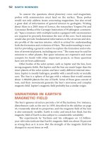
At its centre, the Earth has a solid inner core, 1370 km in radius, made from iron with some nickel
(see Figure 2.1). This is surrounded by an outer core, about 2000 km thick, also of iron with nickel,
but liquid, although of very high density. Movement in the outer core acts like a self-excit-ing dynamo
and generates the Earth’s magnetic field, which deflects charged particles reaching the Earth from
space. Outside the outer core, the mantle, made from dense but somewhat plastic rock, is about 2900
km thick, and at the surface there is a thin crust of solid rock, about 6 km thick beneath the oceans
and 35 km thick (but less dense) beneath the continents.
Miners observed long ago that the deeper their galleries the warmer they found it to work in them.
Surface rocks are cool, but below the surface the temperature increases with depth. This is called the
‘geothermal gradient’. A little of the Earth’s internal heat remains from the time of the planet’s
formation, but almost all of it is due to the decay of the radioactive elements that are distributed
widely throughout the mantle and crustal rocks. The value of the geothermal gradient varies widely
from place to place, mostly between 20 and 40°C for every kilometre of depth, but in some places,
Figure 2.1 Structure of the Earth (not to scale)
Earth Sciences / 21
such as Ontario, Canada, and the Transvaal, South Africa, it is no more than 9 or 10°C per kilometre
(HOLMES, 1965, ch. XXVIII, p. 995). Because of the low thermal conductivity of rock, very little
of this heat reaches the surface and it has no effect on the present climate.
Where the gradient is anomalously high, however, it can be exploited as a source of geothermal
energy. In volcanic regions, such as New Zealand, Japan, Iceland, and Italy, water heated below
ground may erupt at the surface as geysers, hot springs, or boiling mud. More often it fails to reach
the surface and is trapped at depth, heated by the surrounding rock. A borehole drilled into such a
reservoir may bring hot water to the surface where it can be used. In some places a body of dry
subsurface rock is much hotter than its surroundings. In principle this can also be exploited, although
experimental drilling, for example some years ago in Cornwall, Britain, has found the resulting
energy rather costly. The technique is to drill two boreholes and detonate explosive charges at the
bottom, to fracture the rock between them and so open channels through it. Cold water is then
pumped at pressure down one borehole; it passes through the hot rock and returns to the surface
through the other borehole as hot water.
This exploitation of geothermal energy is not necessarily clean. Substances from the rock dissolve into
the water as it passes, so it returns to the surface enriched with compounds some of which are toxic.
The solution is often corrosive and must be kept isolated from the environment and its heat transferred
by heat exchangers. Nor is the energy renewable. Removal of heat from the rock cools it faster than it
is warmed by radioactive decay, so eventually its temperature is too low for it to be of further use.
Similarly, the abstraction of subsurface hot water depletes, and eventually empties, the reservoir.
Although subsurface heat has no direct climatic effect, there is a sense in which it does have an
indirect one. Material in the mantle is somewhat plastic. Slow-moving convection currents within
the mantle carry sections of the crustal rocks above them, so that over very long time-scales the
crustal material is constantly being rearranged.
2
On Earth, but possibly on no other solar-system
planet, the crust consists of blocks, called ‘plates’, which move in relation to one another. The
theory describing the process is known as ‘plate tectonics’ (GRAHAM, 1981). At present there
are seven large plates, a number of smaller ones, and a still larger number of ‘microplates’. The
boundaries (called ‘margins’) between plates can be constructive, destructive, or conservative. At
constructive margins two plates are moving apart and new material emerges from the mantle and
cools as crustal rock to fill the gap, marked by a ridge. There are ridges near the centres of all the
world’s oceans. Where plates move towards one another there is a destructive margin, marked by
a trench where one plate sinks (is subducted) beneath the other. At conservative margins two
plates move past one another in opposite directions (see Figure 2.2). There are also collision
zones, where continents or island arcs have collided. In these, all the oceanic crust is believed to
have been subducted into the mantle, leaving only continental crust. Such zones may be marked in
various ways, one of which is the presence of mountains made from folded crustal rocks. An
island arc is a series of volcanoes lying on the side of an ocean trench nearest to a continent. The
volcanoes are due to the subduction of material.
Slowly but constantly the movement of plates redistributes the continents carried on them. A glance at
a map shows the apparent fit between South America and Africa, but for 40 million years or more prior
to the end of the Triassic Period, about 213 million years ago, all the continents were joined in a
supercontinent, Pangaea, surrounded by a single world ocean, Panthalassa. Pangaea then broke into
two continents, Laurasia in the north and Gondwana in the south, separated by the Tethys Sea, of
which the present Mediterranean is the last remaining trace. The drift of continents in even earlier
times has now been reconstructed, with the proposing of a supercontinent called Rodinia that existed
about 750 million years ago (DALZIEL, 1995). The Atlantic Ocean opened about 200 million years
ago and it is still growing wider by about 3–5 cm a year. A little more than 100 million years ago India
22 / Basics of Environmental Science
Figure 2.2 Plate structure of the Earth and seismically active zones
Earth Sciences / 23
separated from Antarctica. The Indian plate began subducting beneath the Eurasian plate and as
India moved north the collision, about 50 million years ago, raised the Himalayan mountain
range. India is still moving into Asia at about 5 cm a year and the mountains are still growing
higher (WINDLEY, 1984, pp. 161 and 310), although the situation is rather complicated. Rocks
exposed at the surface are eroded by ice, wind, and rain, so mountains are gradually flattened.
At the same time, the crumpling that produces mountains of this type increases the mass of
rock, causing it to sink into the underlying mantle. This also reduces the height of large mountain
ranges. It is possible, however, for the eroded material to lighten the mountains sufficiently to
reduce the depression of the mantle, causing them to rise, and there is reason to suppose this is
the case for the Himalayas (BURBANK, 1992). The Red Sea is opening and in time will become
a new ocean between Africa and Arabia.
The distribution of land has a strong influence on climates. If there is land at one or other pole, ice
sheets are more likely to form. The relative positions of continents modify ocean currents, which
convey heat away from the equator, and the size of continents affects the climates of their interiors,
because maritime air loses its moisture as it moves inland. The Asian monsoon is caused by pressure
differences to the north and south of the Himalayas. In winter, subsiding air produces high pressure
over the continent and offshore winds, with very dry conditions inland. The word ‘monsoon’ simply
means ‘season’ (from the Arabic word for ‘season’, mausim) and this is the winter, or dry, monsoon.
In summer, pressure falls as the land warms, the wind direction reverses, and warm, moist air flows
across the ocean toward the continent, bringing heavy rain. This is the summer, wet monsoon. Plate
tectonics exerts a very long-term influence, of course, and other factors modify climates in the
shorter term, but the distribution of land and sea determines the overall types of climate the world is
likely to have (HAMBREY AND HARLAND, 1981).
Plate tectonics affects the environment more immediately and more dramatically. The movement
of plates causes earthquakes, because it tends to happen jerkily as accumulated stress is
released, and is associated with volcanism due to weakening of the crust at plate margins.
Earthquakes cause damage to physical structures, which is the direct cause of most injuries,
and those which occur beneath the sea produce tsunami (www.geophys.washington.edu/tsunami/
general/physics/physics.html). These are shock waves affecting the whole water column. No
more than a metre high and with a wavelength of hundreds of kilometres, but travelling at
more than 700 km h
-1
, on reaching shallow water they rise to great height and destructive
power (ALLABY, 1998, pp. 54–60).
If volcanic ash reaches the stratosphere it can cause climatic cooling, but volcanic eruptions are
more usually associated with damage to human farms and dwellings. This arises partly because of
the beneficial effect volcanoes can have. Volcanic ash and dust are often rich in minerals and rejuvenate
depleted soils. Farmers can grow good crops on them, which is why there tend to be cultivated fields
at the foot and even on the lower slopes of active volcanoes.
7 The formation of rocks, minerals, and geologic structures
Volcanoes create environments. This was demonstrated very dramatically, and shown on televi-sion,
in 1963, when a new submarine volcano called Surtsey (volcano.und.nodak.edu/vwdocs/volc_images/
europe_west_asia/surtsey.html) erupted to the south of Iceland. The eruption was extremely violent,
because sea water entered the open volcanic vent, and steam, gas, pieces of rock, and ash were
hurled many kilometres into the air. Since then eruptions of this type have been called ‘Surtseyan’.
The lava cone was high enough to rise above the surface, where it formed what is now the island of
24 / Basics of Environmental Science
Surtsey. As it cooled, sea birds began to settle on it.
3
They carried plant seeds and slowly plants and
animals began to colonize the new land.
Even the damage caused by destructive eruptions is repaired, although this can take a long time. The
1883 eruption of Krakatau, in the Sunda Strait between Java and Sumatra, Indonesia, destroyed
almost every living thing on Krakatau itself and on two adjacent islands. Three years later the lava
was covered in places by a thin layer of cyanobacteria, and a few mosses, ferns, and about 15 species
of flowering plants, including four grasses, had established themselves. By 1906 there was some
woodland, which is now thick forest. The only animal found in 1884 was a spider, but by 1889 there
were many arthropods and some lizards. In 1908, 202 species of animals were living on Krakatau
and 29 on one of the islands nearby, although bats were the only mammals. Rats were apparently
introduced in 1918. Species continued to arrive and 1100 were recorded in 1933 (KENDEIGH,
1974, pp. 24–25).
Rock that forms from the cooling and crystallization of molten magma is called ‘igneous’, from the
Latin igneus, ‘of fire’, and all rock is either igneous or derived from igneous rock. This must be so,
since the molten material in the mantle is the only source for entirely new surface rock. If the magma
reached the surface before cooling the rock is known as ‘extrusive’; if it cooled beneath the surface
surrounded by older rock into which it had been forced, it is said to be ‘intrusive’. Intrusive rock may
be exposed later as a result of weathering. It is not only igneous rocks that can form intrusions. Rock
salt (NaCl) can accumulate in large amounts beneath much denser rocks and rise through them very
slowly to form a salt dome. Salt domes are deliberately sought by geologists prospecting for oil but
occasionally they can break through the surface. When this happens the salt may flow downhill like
a glacier.
The character of the rock depends first on its chemical composition. If it is rich in compounds of iron
and magnesium it will be dark (melanocratic); if it is rich in silica, as quartz and feldspars, it will be
light in colour (leucocratic). Rock between the two extremes is called ‘mesocratic’. The rock comprises
minerals, each with a particular chemical composition, and minerals crys-tallize as they cool. Whole
rock is quarried for building and other uses; many minerals are mined for the chemical substances
they contain, especially metals, and some are valued as gemstones. Crystallization proceeds as atoms
bond to particular sites on the surface of a seed crystal, forming a three-dimensional lattice. It can
occur only where atoms have freedom to move and so the more slowly a molten rock cools the larger
the crystals it is likely to contain. The crystal size gives the rock a grain structure, which also contributes
to its overall character. The type of rock is also determined by the circumstances of its formation.
Lava that flows as sheets across the land surface or sea bed often forms basalt, a dark, fine-grained,
hard rock. Basalt covers about 70 per cent of the Earth’s upper crust, making it the commonest of all
rocks; most of the ocean floor is of basalt overlain by sediments and on land it produces vast plateaux,
such as the Deccan Traps in India. Intrusive igneous rocks are usually of the light-coloured granite
type. Beyond this, however, the identification and classification of igneous rocks are rather
complicated.
4
Rocks formed on the ocean floor may be thrust upward to become dry land or exposed when the
sea level falls. Tectonic plate movements are now believed to be the principal mechanism by
which this occurs. Where two plates collide the crumpling of rocks can raise a mountain chain,
as is happening now between the Indian and Eurasian plates, raising the Himalayan chain. The
Himalayas, which began to form some 52–49 million years ago following the closure of the
Tethys Sea, are linked to the Alps, which began forming about 200 million years ago owing to
very complex movements of a number of plates (WINDLEY, 1984, pp. 202–308). The formation
of a mountain chain by the compression of crustal rocks is known as an ‘orogeny’ (or
‘orogenesis’).
Earth Sciences / 25
The British landscape was formed by a series of orogenies. The first, at a time when Scotland was
still joined to North America, began about 500 million years ago and produced the Caledonian-
Appalachian mountain chain (WINDLEY, 1984, pp. 181–208) as well as the mountains of northern
Norway. The Appalachians were later affected by the Acadian orogeny, about 360 million years ago,
and the Alleghanian orogeny, about 290 million years ago. Europe was affected by the Hercynian
and Uralian orogenies, both of which occurred at about the same time as the Alleghanian. Figure 2.3
shows the area of Europe affected by several orogenies.
5
Igneous intrusions can be exposed through the weathering away of softer rocks surrounding them. Such
an exposed intrusion, roughly circular in shape and with approximately vertical sides, is called a ‘boss’ if
its surface area is less than 25 km
2
and a ‘batholith’ if it is larger (and they are often much larger).
Dartmoor and Bodmin Moor, in Devon and Cornwall, Britain, lie on the surface of granite batholiths.
Mountains are not always formed from igneous rocks, however. There are fossil shells of marine
organisms at high altitudes in the Alps and Himalayas, showing that these mountains were formed
by the crumpling of rocks which had formed from sea-bed sediments.
Many sedimentary rocks are composed of mineral grains eroded from igneous or other rocks and
transported by wind or more commonly water to a place where they settle. Others, said to be of
‘biogenic’ origin, are derived from the insoluble remains of once-living organisms. Limestones, for
example, are widely distributed. Most sediments settle in layers on the sea bed, to which rivers have
carried them. Periodic changes in the environmental conditions in which they are deposited may
cause sedimentation to cease and then resume later, and chemical changes in the water or the sediment
itself will be recorded in the sediments themselves and in the rocks into which they may be converted.
Figure 2.3 The mountain-forming events in Europe
Note: The thick lines (- • - • -) mark the Alpine orogeny
26 / Basics of Environmental Science
Sandstones are perhaps the most familiar sedimentary rocks, consisting mainly of sand grains, made
from quartz (silica, SiO
2
) which crystallized originally into igneous rock. Clay particles, much smaller
than sand grains, can pack together to make mudstones. Sediments rich in calcium carbonate, often
consisting mainly of the remains of shells and containing many fossils, form limestone and dolomite
(sometimes known as ‘dolostone’ to distinguish it from the mineral called dolomite) (HOLMES,
1965, ch. VI, pp. 118–141). Particles deposited as sediments are changed into rock by the pressure of
later deposits lying above them and the action of cementing compounds subsequently introduced
into them. The process, occurring at low temperature, is called ‘diagenesis’. Some sedimentary
rocks are very hard and many, especially sandstones and limestones, make excellent and durable
building stone. Once formed, a sedimentary rock is subject to renewed weathering, especially if it is
exposed at the surface, so sedimentary rocks continually form and re-form.
Sediments are deposited in horizontal layers, called ‘beds’, but subsequent movements of the crust
often fold or fracture them. It is not unusual for beds to be folded until they are upside down, and the
reconstruction of the environmental conditions under which sediments were deposited from the
study of rock strata often begins by seeking to determine which way up they were when they formed.
All in all, the interpretation of sedimentary structures can be difficult.
6
Figure 2.4 shows the sequence
of events by which sedimentary structures may be folded, sculptured, and then subside to be buried
beneath later beds producing an unconformity.
Figure 2.4 Stages in the development of an unconformity
Earth Sciences / 27
The extreme conditions produced by the folding and shearing of rock can alter its basic structure by
causing some of its minerals to recrystallize, sometimes in new ways. This process, called
‘metamorphism’, also happens when rock of any type comes into contact with molten rock, during
the intrusion of magmatic material for example. Marble is limestone or dolomite (dolostone) that
has been subjected to metamorphism at high temperature. Such shells as it contained are completely
destroyed as the calcium carbonate recrystallizes as the mineral calcite. If quartz or clay particles are
present, new minerals may form, such as garnet and serpentine. Hard limestone containing fossils is
often called marble, but there are no fossils in true marble.
Slate is also a metamorphic rock, derived from mudstone or shale, in which the parallel align-ment
of the grains, due to the way the rock formed, allows the rock to cleave along flat planes (HOLMES,
1965, pp. 168–170). It may contain fossils, although they are uncommon and usually greatly deformed,
because slate forms when the parent sedimentary rock is squeezed tightly between two bodies of
harder rock that are moving in parallel but opposite directions, so its particles, and fossils, are dragged
out. It is this that gives slate its property of ‘slaty cleavage’ which, with the impermeable surface
imparted at the same time, makes it an ideal roofing and weatherproofing material. Metamorphic
rocks are widely distributed and with practice you can learn to recognize at least some of them.
7
All the landscapes we see about us and the mineral grains that are the starting material for the soils
which form over their surfaces are produced by these processes. The intrusion or extrusion of igneous
rock supplies raw material. This weathers to provide the mineral grains which become soil when
they are mixed with organic matter, or is transported to a place where it is deposited as sediment.
Pressure converts sediments into sedimentary rocks, which may then be exposed by crustal movements,
so that erosion can recommence. Metamorphic rocks, produced when other rocks are subjected to
high pressures and/or temperatures, are similarly subject to weathering. It is the cycling of rocks,
from the mantle and eventually back to it through subduction, that produces the physical and chemical
substrate from which living organisms can find subsistence.
8 Weathering
No sooner has a rock formed than it becomes vulnerable to attack by weathering. The word
‘weathering’ is slightly misleading. We associate it with wind, water, freezing, and thawing. These
are important agents of weathering, but they are not the only ones. Weathering can be chemical as
well as physical and it often begins below ground, completely isolated from the weather.
Beneath the surface, natural pores and fissures in rocks are penetrated by air, containing oxygen and
carbon dioxide, and by water into which a wide variety of compounds have dissolved to make an
acid solution. Depending on their chemical composition, rock minerals may dissolve or be affected
by oxidation, hydration, or hydrolysis (HOLMES, 1965, pp. 393–400). Oxidation is a reaction in
which atoms bond with oxygen or lose electrons (and other atoms gain them, and are said to be
‘reduced’). Hydration is the bonding of water to another molecule to produce a hydrated compound;
for example, the mineral gypsum (CaSO
4
.2H
2
O) results from the hydration of anhy-drite (CaSO
4
).
Hydrolysis (lysis, from the Greek lusis, ‘loosening’) is a reaction in which some parts of a molecule
react with hydrogen ions and other parts with hydroxyl (OH) ions, both derived from water, and this
splits the molecule into two or more parts.
The result of chemical weathering can be seen in the limestone pavements found in several parts of
England, Wales, and Ireland.
8
South Devon, England, is famous for its red sandstones, well exposed
in the coastal cliffs of the Torbay area. These date from the Devonian Period, some 400 million years
28 / Basics of Environmental Science
ago, when what is now Devon was a hot, arid desert. The desert sand contained some iron, which
was oxidized to its insoluble red oxide, giving the sandstone its present colour.
Limestone pavement
A distinctive feature, sometimes covering a large area, that occurs in many
parts of the world. It forms when horizontal limestone beds are exposed by the
erosion of any material that may once have covered them and joints within
them are penetrated by rain water carrying dissolved CO
2
. This weak carbonic
acid (CO
2
+ H
2
O → H
+
+ (HCO
3
)
-
) reacts with calcium carbonate to produce
calcium bicarbonate, which is soluble in water and is carried away. This widens
the joints to form deep crevices (called ‘grikes’ in England) separated by raised
‘clints’. Small amounts of soil accumulating in the sheltered grikes provide a
habitat for lime-loving plants, making limestone pavements valuable botani-
cally. At a deeper level, the grikes may join to form caves. Particular areas of
limestone pavement are protected in Britain by Limestone Pavement Orders
issued under the Wildlife and Countryside Act 1981, mainly to prevent the
stone being taken to build garden rockeries and for other ornamental uses.
Iron oxidizes readily and this form of weathering has produced hematite (Fe
2
O
3
) , one of the most
important iron ore minerals, some of which occurs in banded ironstone formations, 2–3 billion years
old, composed of alternating bands of hematite and chert (SiO
2
). Iron and other metals can also be
concentrated by hydrothermal, or metasomatic, processes. Near mid-ocean ridges, where new basalt
is being erupted on to the sea bed, iron, manganese, and some other metals tend to separate from the
molten rock and are then oxidized and precipitated, where particles grow to form nodules, sometimes
called ‘manganese nodules’ because this is often the most abundant metal in them. Vast fields of
nodules, containing zinc, lead, copper, nickel, cobalt, silver, gold, and other metals as well as
manganese and iron, have been found on the floor of all the oceans (KEMPE, 1981). A few years ago
serious consideration was given to the possibility of dredging for them, but at present metals can be
obtained more cheaply by conventional mining on land.
Hydrothermal weathering, in which hot solutions rise from beneath and react with the rocks they
encounter, produces a range of commercially valuable minerals, perhaps the best known of which is
kaolin, or ‘china clay’. This material was first discovered in China in 500 BC and was used to make
fine porcelain, hence the names ‘china clay’ and ‘kaolin’, from kao ling, meaning ‘high ridge’, the
type of landscape in which it occurred. Today it is still used in white ceramics, but most is used as a
filler and whitener, especially in paper. The paper in this book contains it. Kaolin deposits
(www.wbb.co.uk/)Welcome.htm) occur in several countries, but the most extensively mined ones are
in Cornwall and Devon, Britain.
Kaolin is a hydrated aluminium silicate, Al
2
O
3
2SiO
2
.2H
2
O, obtained from the mineral kaolinite. The
British deposits occur in association with the granite batholiths and bosses intruded during the
Hercynian orogeny. Granites consist of quartz crystals, mica, and feldspars. Feldspars are variable in
composition. All are aluminium silicates, those associated with the kaolinite deposits being plagioclase
feldspars, relatively rich in sodium. As the intruded granite was cooling, it was successively exposed
to steam, boron, fluorine, and vaporized tin. The feldspar reacted with these, converting it into kaolinite
(the process is known as kaolinization), a substance consisting of minute white hexagonal plates
Earth Sciences / 29
which are separated from the rock industrially by washing and precipitation, leaving a residue of
quartz grains (a white sand) and mica. About 15 per cent of the material is recovered as kaolin
(www.kaolin.com/ccpmin.htm), 10 per cent is mica waste, and 75 per cent is sand, which is also
waste although it has found some use for building and landscaping. In some places the kaolinization
process has been completed from above, possibly by humic or other acids from overlying organic
material, but most of the kaolinite formed at depth is overlain by unaffected granite, probably because
the upward movement of acidic fluids was halted by the absence of veins or joints it could attack.
The resulting deposits are funnel-shaped, extending in places to depths of more than 300 m.
Bauxite, the most important ore of aluminium, is also produced by the chemical weathering of
feldspars, in this case by hydration. Bauxite is a mixture of hydrous aluminium oxides and hydroxides
with various metals as impurities; to be suitable for mining it should contain 25–30 per cent of
aluminium oxide.
Bauxite is a variety of laterite, one product of the kind of extreme weathering of soil called
‘laterization’. The word ‘laterite’ is from the Latin later, meaning ‘brick’, and laterite is brick-hard.
Laterization occurs only in some parts of the seasonal tropics, where soils are derived from granite
parent material, but it is possible that removing the forest or other natural vegetation in such areas
may trigger the formation of laterites. These can be broken by ploughing.
Except on steep slopes, tropical soils overlying granite can be up to 30 m deep. Naturally acidic water
from the surface percolates through them, steadily eating away at the parent rock beneath, and plants
draw the water up again through their roots. Water is also drawn upward by capillary attraction through
tiny spaces between soil particles and evaporates from the surface. If the rainfall is fairly constant
through the year, the movement of water is also constant, but if it is strongly seasonal, evaporation
exceeds precipitation during the dry season and mineral compounds dissolved in the soil water are
precipitated, the least soluble being precipitated first. Provided vegetation cover is adequate, with roots
penetrating deep into the soil, the minerals will not accumulate in particular places and when the rains
return they will be washed away. If there is little plant cover, however, they may accumulate near the
surface. The most insoluble minerals are hydroxides of iron and aluminium (kaolinite) and they are
what give many tropical soils their typically red or yellow colour (HOLMES, 1965, pp. 400–401). Soil
developed over granite will contain sand, or quartz grains, and clays derived from feldspars in varying
amounts. Figure 2.5 shows how these can grade almost imperceptibly from one to the other and from
both into laterite. Laterite layers or nodules are hard, but not usually thick, because, being impermeable,
they prevent further percolation of water downwards into the soil and thus bring the laterization process
to an end. Erosion of the surface layer may then expose the laterite.
Figure 2.5 Gradation of clay and sand to laterite
Source: Holmes, Arthur. 1965. Principles of Physical Geology. Nelson, Walton-
on-Thames
30 / Basics of Environmental Science
Laterization does not necessarily render a soil useless and many relatively laterized soils are cultivated,
although some soils resembling lateritic soils, for example in parts of the eastern United States, are
not truly laterized. Indeed, there are doubts about the extent to which laterization is occurring at
present. Lateritic soils in the West Indies, Indonesia, Australia, India, and China may well be of
ancient origin (HUNT, 1972, p. 193).
Living organisms contribute to weathering. By moving through soil they assist the penetration of air
and water, and the decomposition of organic material releases acids and carbon dioxide, some of
which dissolves into the soil water. Biological activity contributes greatly to the formation of soil.
Physical weathering is also important in soil formation, especially in its initial stages, but it can also
degrade soils through erosion. Thermal weathering, which is the expansion and contraction due to
repeated heating and cooling, causes rocks to flake, especially if water is held within small crevices.
Small particles detached from the rock may then be carried by the wind and if they strike other rocks
more particles may be chipped from them. Depending on their size, the particles may be carried well
clear of the ground or may roll and bounce along the surface; the process is called ‘saltation’. Most
serious erosion is due to water, however. All water flowing across the land surface carries soil particles
with it. This can lead to the formation of rills and gullies into which more particles are washed and
then transported, or where water flows as sheets whole surface layers can be removed. In addition to
this, all rivers erode their banks, and waves erode the shores of lakes and the sea (HUDSON, 1971,
pp. 33–46).
These processes are entirely natural and part of the cycles by which originally igneous rocks are
converted into sediments and landforms are made and age, but human activities can accelerate them.
The UN estimates that in the world as a whole, some 1.093 billion hectares (ha) of land have been
degraded by water erosion, 920 million ha by sheet and surface erosion and a further 173 million ha
by the development of rills and gullies. Of the total area subject to serious degradation by water, 43
per cent is attributed to the removal of natural vegetation and deforestation, 29 per cent to over-
grazing, 24 per cent to poor farming practices, such as the use of machinery that is too heavy for the
soil structure to support and the cultivation of steep slopes, and 4 per cent to the over-exploitation of
vegetation (TOLBA AND EL-KHODY, 1992, pp. 149–150). There is, however, some evidence that
modern farming techniques can reduce soil erosion substantially. A study of a site in Wisconsin
found that erosion in the period 1975–93 was only 6 per cent of the rate in the 1930s (TRIMBLE,
1999). This may be due to higher yields from the best land, combined with methods of tillage designed
to minimize erosion (AVERY, 1995).
Weathering is the general name given to a variety of natural processes by which rock is recycled and
soil and landscapes created. It creates and alters environments, but human activities can accelerate it
on vulnerable land, degrading natural habitats and reducing agricultural productivity.
9 The evolution of landforms
The weathering of exposed rocks and the erosion and transport of loose particles create the landscapes
we see and change them constantly. Change is usually slow, but not always. The 1952 Lynmouth
flood was very sudden (see box), but not far away there are landscapes which record conditions long
ago. During the most recent glaciation the ice sheets did not extend as far south as Devon, but on the
high granite batholith of Dartmoor the climate was severe, with permanently frozen ground
(permafrost), and to this day parts of Dartmoor are periglacial landscapes. Rock masses were shattered
by the repeated freezing and thawing of water that penetrated crevices.
Earth Sciences / 31
In winter the water expanded as it froze, widening the crevices, and in summer the water shrank as
it melted, releasing flakes of rock and also large boulders. For those few weeks in summer when the
weather was warm enough to thaw the surface layers of the permafrost, turning soil locked solid by
ice into wet mud, the mud, together with large boulders embedded in it, slid downhill, only to be
brought to a halt when the temperature dropped and the mud froze again. Today, although there is no
permafrost, the scattering of boulders around the tors remains as a record of the climate more than
10000 years ago. Similar periglacial processes acting on the weak, jointed chalk of southern England
caused slopes to retreat through the loss of material from their faces and produced large deposits of
the angular debris comprising fragments of varying sizes called ‘coombe rock’ or sometimes ‘head’
(other definitions confine ‘head’ to deposits other than chalk). There are similar periglacial relics in
North America and elsewhere in Europe.
The Lynmouth flood
On Exmoor, in south-west England, in the summer of 1952, almost 230 mm of
rain fell in 24 hours on to land that was already waterlogged. The water drained
northward, carried in two rivers, the East and West Lyn, which enter the sea
together at the small village of Lynmouth, falling some 300 m in rather more
than 1 km. Unable to carry the volume of water, during the night of 15 and 16
August both rivers flooded and the overflow from the West Lyn cut a new
channel that took it through Lynmouth, rejoining the original course at the mouth.
Houses, roads, and bridges were destroyed, an estimated 40000 tons of trees,
soil, boulders, and rubble and masonry from collapsed structures piled up in
the village, and 31 people were killed. The disaster was caused by nothing
more than rain. Lynmouth was subsequently restored and is now a popular
and attractive holiday resort.
Present permafrost regions occur in latitudes much higher than Britain. In Canada and Alaska within
the Arctic Circle in places the permafrost is 400 m thick and in parts of Siberia it is 700 m thick. In
Resolute Bay, in the Canadian Arctic, it extends to a depth of about 1000 m. Overall, nearly 20 per
cent of the land area within the Arctic Circle is permafrost, and has remained in this state since the
retreat of the ice sheets that once covered it.
Ice sheets are major sculptors of landscapes. As they move, they scour away all soil and other loose
material, pushing it ahead and to the sides of them, where it may form moraines. They smooth
angular rocks and the weight of the ice depresses the ground beneath. During a major glaciation ice
sheets may grow to a thickness of more than 2500 m and depress the underlying surface by 600 m,
which may take it to below sea level. As the ice retreats, the surface rises again, but it is a slow
process, at least as measured on a human scale. Northern Canada, where shore-lines rose several
tens of metres in less than 1000 years, and Scandinavia are still rising to compensate for the loss of
their ice sheets around 10000 years ago; in Scandinavia the surface was depressed by about 1000 m
and has subsequently risen by 520 m. This ‘glacioisostasy’ demonstrates the slight flexibility of the
Earth’s crust.
Because there is a lag between the disappearance of the ice sheets and the recovery of the original
surface elevation, bowls may remain where the ice was thickest. Depending on their location, these
may be flooded by the sea or fill with fresh water. The North American Great Lakes and the Baltic
Sea were made in this way. On a much smaller scale, so were the lakes of the English Lake District.
32 / Basics of Environmental Science
Ice accumulating in a pre-existing hollow will erode the sides to the open-sided, approximately
circular shape of a cirque (also known as a ‘corrie’ or ‘cwm’). Where a relatively narrow glacier
flows into the sea the trough it excavates may later form a fjord, known in Scotland as a ‘sea loch’.
Some fjords are more than 1200 m deep. In latitudes higher than about 50°, ice has been the major
geomorphological (‘landscape-forming’) agency.
Soil will tend to move slowly downslope by ‘soil creep’, caused by the expansion and contraction of material
due to repeated wetting and drying, or ‘solifluction’, where the soil is lubricated by rain water (formerly the
term ‘solifluction’ was applied only to periglacial environments where the ground is frozen for part of the
year, but it is now used more widely and is recognized as an important process in some tropical areas). The
rate of soil creep has been measured in the English Pennines as between 0.5 and 2.0 mm at the surface and
0.25 to 1.0 mm in the uppermost 10 cm (SMALL, 1970, p. 224). If the soil is deep and the underlying rock
extensively weathered, large masses may slip suddenly and move rapidly as ‘earth flows’. The collapse of
coal tips at the Welsh village of Aberfan in 1966 was of this type (in this case known strictly as a ‘flowslide’).
The tips had been built over springs. Tip material absorbed the water, greatly increasing its weight but
simultaneously lubricating it until it lost its inertia catastrophically (SMALL, 1970, p. 29–34). Earthquakes
can break the bonds holding soil particles together, resulting in earth flows of dry material.
There are several ways in which masses of rock and earth can move downslope (HOLMES, 1965, p.
481). All such movements alter the shape of slopes, generally smoothing and reducing them. Figure
2.6 shows the stages by which this happens:
(1) material from the free face is detached
and falls to form a scree which buries a
convex lower slope; (2) further falls cause
the free face to retreat until it disappears
altogether, leaving a slope that grades
smoothly to the level of the higher ground;
(3) the slope itself then erodes further. It can
also happen that accumulated water increases
the weight of a mass of weathered material
until it shears away and slides down a
concavely curved shear plane between it and
the adjacent material. Because of the curved
slope, the sliding layers are tilted backwards
as they descend, so the toe of the slide is
tipped upwards, forming a barrier behind
which further debris will be held. This is a
‘rotational slide’, examples of which can be
seen in several places along the south coast
of England and in the Isle of Wight. Most
failures are quite complex and involve more
than one mechanism.
Geomorphology, the study of landforms and
the processes by which they are produced and
change, began with the work of an American
geologist, William Morris Davis (1850–
1934), of Harvard University. He proposed
that landscapes evolve through a ‘cycle of
erosion’ (the ‘Davisian cycle’). This begins
Figure 2.6 Slope development
Earth Sciences / 33
when land is raised by tectonic movements. In a young landscape hills slope steeply and the slope of
river beds is irregular. As the landscape matures, hill slopes become gentle and river beds slope smoothly.
Eventually, the old landscape has eroded to a gently rolling peneplain (‘almost a plain’), a word Davis
coined. His idea was (posthumously) challenged, in 1924, by the German geologist Walther Penck
(1888–1923), who argued that once a slope has settled at an angle which is mechanically stable for the
material of which it is composed, it will maintain that angle. Erosion will wear away its face, but will
not make it more shallow, so the face will retreat but the angle will remain fairly constant, and the
steeper the slope the faster it will erode, because the slow-moving weathered material on a shallow
slope will protect the underlying surface. Thus, if a slope is steeper near the bottom than it is higher up,
the lower slope will erode faster than the upper slope and the structure will collapse. As the argument
developed, geomorphologists came to realize that a true understanding of ‘the slope problem’ can best
be gained from studies of low-latitude landscapes that have not been formed mainly by glacial action,
as were those on which the theories of Davis and Penck were largely based (SMALL, 1970, pp. 194–
224). Interest in the topic is not purely academic, for an understanding of how rock and soil behaves on
sloping ground is necessary for engineers calculating the risks of landslides, erosion, and flooding, and
devising schemes to minimize them. The matter is of major environmental importance.
Rivers provide the principal means by which particles eroded from surface rocks are transported from
the uplands to the lowlands and eventually to the sea. Rivers are also major landscape features in their
own right and, by cutting channels across the surface, important agents in the evolution of landscapes.
It is not only mineral particles they transport, of course. Water draining into a river from adjacent land
also contains organic matter and dissolved
plant nutrients, and rivers also carry those
substances we discharge into them as an
apparently convenient method of waste
disposal. They are also a major source of water
supplied for domestic and industrial use.
Water drains from higher to lower ground,
moving slowly as ground water between the
freely draining soil and an impermeable layer
of rock or clay, eventually emerging at the
surface as a spring, seeping from the ground,
or feeding directly into a river. The ‘water
table’ is the upper limit of the ground water,
below which the soil is fully saturated. These
terms have the same meanings in British and
North American usage, but confusion can
arise over ‘watershed’, which has two
different meanings. A drainage system
removes water from a particular area, and one
such area is separated from adjacent areas.
In Britain, the area from which water is
removed by a particular drainage system is
called a ‘catchment’ and in North America it
is called a ‘watershed’. One catchment is
separated from another by a ‘divide’, which
in Britain is sometimes known as a
‘watershed’, and within a catchment the
drainage system forms a pattern. Figure 2.7
Figure 2.7 Drainage patterns. A, subparallel;
B, dendritic; C, semi-denritic; D, trellised;
E, rectangular; F, radial
34 / Basics of Environmental Science
illustrates six of the commonest patterns, but others are possible and real patterns are seldom so
clearly defined as the pictures may suggest. Climate, the type of rock, and the extent of erosion all
play a part in determining the type of pattern that will develop. Dendritic patterns, for example,
usually form on gently sloping land of fairly uniform geologic character. Radial patterns occur around
domed hills and batholiths, and trellis patterns where rivers cross, more or less at right angles,
alternating bands of relatively hard and soft rocks.
As they flow, rivers can be approximately classified into zones, mainly on a biological basis. The
headstream, or highland brook, is small, usually torrential (which means its water flows at more than
90 cms
-1
), and the water temperature varies widely. Few aquatic animals can survive in it. A little
lower, trout can survive in what is still a fast-flowing stream, the troutbeck. Silt and mud begin to
collect at the bottom of the minnow reach or grayling zone, some plants can survive, and the animal
life becomes a little more diverse. In the lowland reach or bream zone the water flows slowly, the
river is often meandering, and animal life is diverse. In this final zone the river flows across the
coastal plain into the estuary.
10 Coasts, estuaries, sea levels
It seems natural to think of an estuary in terms of the river flowing into it, to see it as the end of the
river, with a boundary somewhere offshore where the river meets and merges with the sea. Stand on
a headland overlooking an estuary and this is how it looks, but the picture is misleading. An estuary
is more accurately described as an arm of the sea that extends inland and into which a river flows. An
estuary is dominated by the sea rather than its river, and many estuaries are in fact ‘rias’, or ‘drowned
river valleys’, old river valleys which were flooded at some time in the past when the sea level rose.
The estuaries of south-west England are good examples of rias. In several cases, such as the Camel
in north Cornwall, before the marine transgression that began about 10300 years ago the sea was 36
m below its present level (the sea is still rising at about 25 cm per century), and gently undulating
land, with hills formed from igneous intrusions through Devonian slate which survive now as offshore
islands, extended up to 5 km from the present coast. This land was blanketed with mixed deciduous
forest. Remnants of the forest have been found on the sea bed at several points along the coast and its
botanical and faunal composition determined (JOHNSON AND DAVID, 1982).
Sea levels change and at various times in the past they have been both higher and lower than they are
today, and they are changing still. During glacial periods (ice ages), sea levels fall, because the
volume of the oceans decreases as water evaporated from them accumulates in ice sheets. As the
weight of ice depresses the land beneath it sea levels rise; as the ice sheets melt they also rise; and as
land depressed by the weight of ice rises again when the ice has melted they fall. There is clear
evidence in many places that sea levels were much lower at some time in the past. Raised beaches
can be found that are several metres above the present high-tide level. These are areas of approximately
level ground, nowadays usually vegetated, containing large numbers of shells of marine organisms.
They can have been produced only by the movement of waves and tides over them, at a time when
they formed the shore; they are ancient beaches now some distance from the sea.
The sea bed at the mouth of the Camel estuary is mainly sandy, with sand bars, and there are many
sandy beaches along the adjacent coast. Sand consists primarily of quartz grains weathered and eroded
from igneous rocks inland and transported by the river. They are deposited at the mouth of the estuary,
then transported further by tides and sea currents. As they move they become mixed with varying
amounts of sea shells, most of which are crushed to tiny fragments through being battered by harder
Earth Sciences / 35
stones, producing a beach material with a
relatively high calcium carbonate content;
this was formerly used by farmers as ‘lime’,
to raise the pH of their soils.
Sand that has been transported many miles
by river is deposited where fresh water and
sea water meet. Because sea water is
denser than fresh water the two do not mix
readily and tend to flow in separate
channels. The configuration of these
channels is determined by the topography
of the estuary itself; they may flow side
by side or form a wedge, in which fresh
water rises over the sea water. On an
incoming tide, freshwater and seawater
currents often flow in opposite directions
and marine fish can move considerable
distances inland by keeping to the salt-
water channel.
As the fresh water is forced to rise, it loses energy, and the quantity of material a river can transport,
known as its ‘traction load’ or ‘bed load’, is directly proportional to the energy with which it flows.
This depends in turn on such factors as the potential gravitational energy causing the water to flow
(essentially the height of the river source above sea level), the gradient of the channel, and the
amount of friction caused by contact with the banks and bed (SMALL, 1970, pp. 34–41). As the
river water rises and loses energy, the sand grains sink, falling through the underlying salt water and
on to the bed. Figure 2.8 shows what happens and how over time the deposition of sand can lead to
the formation of a bar at the estuary mouth.
Sand does not remain static on the sea bed and material for the growth of a bar is also provided by
sand being carried landward or along the shore by tides and sea currents. The sea water also loses
energy as it pushes against the fresh water, and the sand it carries is again deposited.
Sand grains are much larger and heavier than the particles of silt rivers also carry. Silt particles are
2–60 micrometres (µm) in diameter, sand grains 60–2000 µm (in the British standard classification;
in the widely used Udden-Wentworth classification they are 4–62.5 µm and 62.5–2000 µm
respectively). Ordinarily, large particles would be expected to settle first and small ones later, but in
an estuary the opposite occurs. Mudbanks, composed of silt, still smaller clay particles and, mixed
with them, organic molecules from the decomposition of the waste products and dead bodies of
biological organisms, form inland of the sand banks. Flocculation is the process responsible for this
phenomenon. Many of the very small particles carry an electrical charge owing to the presence of
bicarbonate (HCO
3
-
), calcium (Ca
2+
), sulphate (SO
4
2-
), and chlorine (Cl
-
) ions. In the boundary zone
where fresh and salt water meet, these particles encounter chlorine, sodium (Na
+
), sulphate, and
magnesium (Mg
2+
) ions, which bond to them and attract more silt particles, so the material forms
clumps larger and heavier than sand grains, and these settle. The organic material mixed with them
provides rich sustenance for bacteria and, closer to the surface, burrowing invertebrate animals,
which provide food for wading birds. The environment is harsh because the salinity of the water
varies widely, so although only a restricted number of species can regulate their osmosis well enough
to survive in the mud, those which succeed do so in vast numbers. Estuarine waters may also be
enriched by a ‘nutrient trap’, where the current pattern causes dissolved plant nutrients to be retained
Figure 2.8 Deposition of sand and formation of an
estuarine sand bar
36 / Basics of Environmental Science
(CLARK, 1977, p. 6). In sheltered areas, plants rooted in the mud trap further sediment. In this way
mangroves extend some tropical coastlines seaward and, in temperate regions, sediment trapped by
saltmarsh vegetation raises the surface until it is beyond the reach of the tides and becomes dry land.
Beach material is transported by currents produced mainly by waves in directions determined by the
angle between the shoreline and prevailing movements of the water. Tides have much less effect. If
the angle between the approaching waves and the shore is less than 90°, water will flow parallel to
the shore, carrying loose beach material with it. This is longshore drift. Its mechanics are complex,
but its effect is to shift material to one end of the beach, where it may be trapped against resistant
material, such as a cliff or groynes built to prevent beach erosion, swept away entirely (and commonly
deposited elsewhere), or deposited where the shoreline turns into the mouth of a bay or estuary and
the current becomes turbulent. Sand or shingle accumulating in this way may eventually rise above
the water as a spit (HOLMES, 1965, pp. 820–822). Longshore drift moves material in such a way as
to rearrange the shoreline so it is at right angles to prevailing waves. This is why waves often appear
to meet the shore at right angles.
Waves are produced mainly by wind. This is obvious enough in the case of the huge waves thrown
against the coast during storms, but less so in the case of the gentle swell that moves against ocean
shores on even the calmest days and in fact is caused by strong winds 1500 km or more from land.
The size of sea waves depends on wind force and the length of time during which it blows, the
distance over which the water is affected (called the ‘fetch’), and the influence of waves that were
generated elsewhere. Some waves are also driven gravitationally. Low atmospheric pressure allows
the sea level to rise beneath it and water flows downhill towards areas where higher pressure produces
a lower sea level.
Beaches are built by waves, and especially by ‘spilling breakers’ which move a long way up the
beach before breaking, spilling a little water from their crests. ‘Plunging breakers’, which collapse
earlier, produce a strong backwash that tends to erode the beach. Where the usual wave pattern is of
spilling breakers arriving at about six to eight a minute, the uppermost part of the beach is likely to
end in a raised mound of coarse sand or pebbles (a ‘berm’).
Where waves crash against a vertical rock face, their force is considerable. It has been measured at
up to 25 t m
-2
(SMALL, 1970, p. 438). If the rock is soft, or has many joints or fissures, this is
enough to erode it. In harder rock, it is enough to violently compress air held in crevices and allow
the air to expand again as the water recedes. This weakens the rock and may produce further cracks
into which air enters, until eventually sections are detached as boulders.
Sea cliffs are the result of the wave erosion of hills and as what used to be a hill is cut back, the base
becomes a gently sloping wave-cut platform and the eroded material accumulates just below the
low-tide limit as a wave-built terrace. Figure 2.9 illustrates the process and shows that it is the
ultimate fate of sea cliffs to be eroded completely, until the land slopes gently from the upper limit of
wave action to the low-tide line.
How long this takes depends on the resistance offered by the rock, the degree to which it is exposed
to the full force of the waves, and the topography of the original high ground. In north Cornwall,
Britain, the very impressive sea cliffs have taken around 10000 years to reach their present condition.
The process may never be completed, because the sea level may reverse its present trend and fall
again. This could happen were the ice sheets to advance in a new glaciation. Alternatively, cliff
erosion may accelerate as the sea level rises. In some places the present sea-level rise is due to
erosion, so it is really a sinking of the land rather than a rising of the sea. It is also believed to be
due, in some places exclusively, to the expansion of sea water due to a warming of the sea as
Earth Sciences / 37
a result of what may be a general climatic warming. Many climatologists predict that such a
warming is likely to continue, but the consequences for sea levels are difficult to estimate and
predictions vary widely.
11 Energy from the Sun
Tides are driven by gravitational energy and plate tectonics by the heat generated by the radioactive
decay of elements in the Earth’s mantle, but the energy driving the atmosphere, oceans, and living
organisms is supplied by the Sun. To a limited extent this energy can also be harnessed directly to
perform useful work for humans. Solar heat can be used directly to warm buildings and water,
desalinate water, and cook food. Sunlight can be converted into electricity. Electrical power can also
be generated from wind and sea waves and, because the atmospheric circulation responsible for
wind and wind-driven waves is driven by solar heat, these are also forms of solar energy.
The outer layer of the Sun, which is what we see and the region from which the Sun radiates, is at a
temperature of about 6000 K and it radiates energy at 73.5×10
6
W from every square metre of its
visible surface (the photosphere; being entirely gaseous, the Sun has no solid surface). The figure
can be calculated because the Sun behaves as a ‘black body’. This is a body that absorbs all the
energy falling on it and radiates energy at the maximum rate possible; the rate is calculated by using
Stefan’s law
9
and is proportional to the absolute temperature raised to the fourth power.
The Sun radiates in all directions and the Earth, being a very small target at a distance of 150 million
km, intercepts 0.0005 per cent of the total. At the top of the Earth’s atmosphere this amounts to about
1360 W m
-2
, a value known as the ‘solar constant’.
Solar output is not as constant as this name suggests. Between 1981 and 1984, it decreased by 0.07
per cent (HIDORE AND OLIVER, 1993, p. 166). This is a small deviation, but a decrease of about
0.1 per cent sustained over a decade would be sufficient to produce major climatic effects and a 5 per
cent decrease might trigger a major glaciation. Cyclical variations in the Earth’s rotation and orbit
also alter the solar constant. These are believed to be the major cause of large-scale climatic change,
and variations in solar output, marked by changes in sunspot activity, are linked to less dramatic
changes, such as the Little Ice Age, a period when average temperatures were lower than at present
which lasted from about 1450 to 1880. Some scientists believe that the recent climatic warming and
rise in atmospheric carbon dioxide concentration are both wholly due to the marked increase in
energy output of the Sun since about 1966 (CALDER, 1999).
Figure 2.9 The development of a sea cliff, wave-cut platform, and wave-build terrace
38 / Basics of Environmental Science
Radiant heat and light are both forms of electromagnetic radiation, varying only in their wavelengths,
and the Sun radiates across the whole electromagnetic spectrum. According to Wien’s law
10
, the
wavelength at which a body radiates most intensely is inversely proportional to its temperature, so
the hotter the body the shorter the wavelength at which it radiates most intensely. This is not
surprising, because electromagnetic radiation travels only at the speed of light (beyond the Earth’s
atmosphere, in space, about 300000 km s
-1
) and the only way its energy can increase is by reducing
the wavelength. Very short-wave (high-energy) gamma (10
-4
–10
-8
µm) and X (10
-3
–10
-5
µm) solar
radiation is absorbed in the upper atmosphere and none reaches the surface. Radiation with a
wavelength between 0.2 and 0.4 µm is called ‘ultraviolet’ (UV); at wavelengths below 0.29 µm,
most UV is absorbed by stratospheric oxygen (O
2
) and ozone (O
3
). The wavelengths between 0.4
and 0.7 µm are what we see as visible light, with violet at the short-wave end of the spectrum and
red at the long-wave end. These are the wavelengths at which the Sun radiates most intensely, with
an intensity peak at around 0.5 µm in the green part of the spectrum. It is the part of the spectrum
to which our eyes are sensitive, for the obvious reason that the most intense radiation is also the
most useful, although some animals have eyes receptive to slightly shorter or longer wavelengths.
Beyond the red end of the visible spectrum lie the infra-red wavelengths (0.7 µm to 1 mm) and,
with increasing wavelengths, microwaves and radio waves, the longest of which have wavelengths
up to about 100 km.
The atmosphere is transparent to wavelengths longer than 0.29 µm, although water vapour absorbs
energy in several narrow bands between 0.9 and 2.1 µm (BARRY AND CHORLEY, 1982, pp. 10
and 15). When radiant energy, as light or heat, strikes the surface of land or water its energy is
absorbed and the surface is warmed. The Earth is not warmed evenly and Figure 2.10 shows how the
energy is distributed. The equator faces the Sun, which is always directly overhead at noon.
Consequently, its radiation is most intense at the equator. With increasing distance from the equator,
the Sun is lower in the sky at all seasons and its radiation covers a larger area less intensely.
Although latitude is obviously important, and places in high latitudes tend to receive less solar
energy than those in low latitudes, cloudiness modifies the general distribution quite strongly. The
equatorial region does not receive the most intense insolation, because for much of the time clouds
shade the surface, reflecting incoming sunlight. Tropical and subtropical deserts, where skies are
mainly clear, receive 50 to 100 per cent more insolation than the equator and the dry interiors of
North America and Eurasia are much sunnier than maritime regions.
Rather less than half of the solar radiation reaching the top of the atmosphere penetrates all the way
to the surface. As Figure 2.11 shows, most of the ‘lost’ incoming radiation is reflected directly back
into space, and about 10 per cent is absorbed or scattered by ozone, water vapour, and particulate
matter in the troposphere.
It is scattering that gives the sky its colour. Radiation bounces off particles (mainly molecules) of
a particular size in relation to its wavelength. All that changes is the direction of the radiation.
There is no loss of energy, but shorter wavelengths scatter more than longer ones. This is called
Rayleigh scattering, after Lord Rayleigh (1842–1919) who discovered it, and it reflects radiation
in all directions. When the Sun is high in a clear sky, violet light is scattered and absorbed very
high in the atmosphere and blue below it. Scattering diffuses the blue light evenly and so the sky
appears blue. If the sky is hazy, dust particles scatter light of all wavelengths and the sky appears
white. When the Sun is low, dust particles scatter light in the orange and red wavelengths, but
shorter wavelengths are absorbed during the much longer passage of the light through the air, and
the sky appears orange or red. Spherical particles larger than those responsible for Rayleigh
scattering (more than about 0.1 µm) scatter light of all wavelengths, mainly without changing its
direction. This is Mie scattering, discovered by Gustav Mie in 1908, and it tends to darken the
Earth Sciences / 39
Figure 2.10 Average amount of solar radiation reaching the ground surface, in kcal cm
-2
yr
-1
(1 kcal=4186.8 J)
40 / Basics of Environmental Science
sky colour by counteracting the effect of Rayleigh scattering; it makes the sky a darker blue after rain
has washed out solid particles.
Once warmed, the Earth also behaves as a black body, radiating energy in the long, infra-red
waveband. All the received energy is reradiated. All the portion which is captured by green plants
and subsequently passed to animals that eat the plants is converted back into heat by the process of
respiration and escapes from the Earth. This must be so, because if captured energy were retained
permanently the Earth would grow continually hotter, and it does not. Overall, the amount of
radiation received from the Sun is equal to the amount radiated into space from the surface of the
Earth, but a proportion of the outgoing energy is retained for a time in the atmosphere. This
produces the ‘greenhouse effect’.
Solar energy can be exploited for domestic and industrial use, as a so-called ‘renewable’ energy
source, but none of the exploitive technologies is free from problems (RAVEN ET AL., 1993,
pp. 234–250).
Figure 2.11 Absorption, reflection, and utilization of solar energy
Earth Sciences / 41
Fast-growing crops, harvested to be burned, are being cultivated in several parts of the world as
‘biomass’ fuel. Willow (Salix species) and similar woody plants can be burned directly, after drying
then chopping and compressing them, which reduces their bulk. Alcohols can be obtained from
plants rich in sugar or starch and either used directly or dehydrated and mixed with gasoline to make
‘gasohol’. Low petroleum prices led to a decline in the number of Brazilian cars being built to run on
‘gasohol’, but in 1999 car manufacturers announced an increase in production in an attempt to boost
car sales. Fiat planned to raise output of these vehicles from 90 in August to 1,300 in September and
Volkswagen planned an increase from 800 to 1,200. General Motors introduced a new model in
September and Ford planned to relaunch its models in the spring of 2000. Methanol, an alternative
liquid fuel, can also be obtained from plant material. Such fuels are renewable because they can be
replaced easily by growing more of the fuel crop, and although they are based on carbon they make
no contribution to the greenhouse effect, because the carbon they release when burned is absorbed
photosynthetically by the plants which replace them; the carbon is recycled. Biomass crops occupy
land, however, and if they are to be grown on the scale needed to supply useful amounts of fuel they
could compete for space with food or fibre crops, and because they sell for a lower price than
conventional crops they may be grown very intensively to maximize yields.
Solar heat is absorbed by a black surface. Manufactured solar collectors exploit this, using the absorbed
heat to warm water, then transferring the heat to a hot water system. Collectors are limited
geographically, because they are most efficient where insolation is greatest and do not work well in
high latitudes. They have been installed on many buildings, usually attached to roofs or walls facing
the Sun, but their high capital cost often makes the energy they provide more expensive than that
supplied by the public utilities. In the tropics, however, direct solar heating can be used to distil
water and for cooking, with real advantages.
Photovoltaic cells can be used in any latitude, because they convert light, not heat, into electrical
power. In years to come this technology may provide useful amounts of energy, but at present its low
efficiency (about 15 per cent) means very large arrays are required and the resulting power is much
more expensive than electricity generated by other means. For many years, scientists and engineers
have been discussing the technical feasibility of constructing truly vast arrays of photovoltaic cells
in geostationary orbit and transmitting the power generated as microwaves to a receiving station on
the surface, where they would be reconverted to electrical power. The amount of energy obtainable
in this way would be great, although it would not be cheap, and at present no one can predict its
environmental consequences.
Sunlight can be concentrated. A device developed in Israel by the commercial arm of the Weizmann
Institute of Science and Boeing uses highly reflective mirrors (heliostats) to track the Sun and reflect
sunlight to another reflector on top of a central tower. This reflector redirects the sunlight to a matrix
of concentrators, which increase the intensity of the light 5000 to 10000 times, compared with the
sunlight reaching the surface outside the facility. The concentrated light is fed to a receiver, called
‘Porcupine’ because it contains hundreds of ceramic pins arranged in a geometric pattern. Compressed
air flowing across the pins is heated and channelled to gas turbines that generate electrical power.
The prototype plant was installed late in 1999.
Wind power is also exploited widely, but it, too, suffers from the fact that although solar energy, as
wind, is abundant, it is variable and very diffuse. The amount of energy captured by a wind turbine
is proportional to the square of the diameter of the circle described by its blades and the cube of the
wind speed (ALLABY, 1992, pp. 194–202) in a 32 km h
-1
wind, a 15-metre-diameter rotor linked to
a generator operating at 50 per cent efficiency generates 24 kW of power. Most modern wind generators
have a rated capacity of about 750 kW and are established in arrays (‘wind farms’), each turbine
occupying about 2 ha, the spacing necessary to avoid mutual interference, therefore up to 3000
42 / Basics of Environmental Science
turbines, occupying 6000 ha, are needed to match the output of a large conventional power station.
The unreliability of the wind means conventional generating capacity must be held available for use
when the wind speed is too low or so high that the blades must be feathered (turned edge-on to the
wind) to stop the rotors turning. Suitable sites for such installations are limited, and in highly valued
open landscapes they tend to be visually intrusive and arouse strong opposition. Were wind power to
provide a substantial proportion of our energy requirements, there could be a risk that the very large
installations might affect local climates by extracting a significant part of the energy of weather
systems.
The vertical movement of sea waves can also be used to generate electricity. The technology
is well advanced, but wave power suffers from disadvantages similar to those of wind power.
The installations need to be large and both they and the cables carrying the energy they generate
to shore must be able to withstand ocean storms. They must also be located in places where
wave movement is large and reliable, but well clear of shipping lanes. This limits the availability
of suitable sites. An alternative device, which occupies a much smaller area, extracts energy
from the oscillation of waves within a cylindrical structure, and energy can also be obtained
in still waters by exploiting the temperature difference between warm surface water and cold
deep water.
Wind and wave power can probably be used most effectively on a small scale in places that are
beyond the reach of conventional energy distribution systems, such as remote, sparsely populated
islands where demand is modest and the cost of links to the mainland high. Direct solar energy,
captured by solar collectors or photovoltaic arrays, may become more popular if they can be
made more efficient and ways can be found to spread the high capital cost over the lifetime of
the installation. Biomass conversion, exploiting energy captured by photosynthesis in green
plants, is perhaps the most promising of the renewable technologies. It requires land that is
surplus to rival agricultural needs; a criterion that perhaps is now being met in many parts of the
European Union.
Compared with the energy our planet apparently receives from the Sun, the amount we derive from
fossil and nuclear fuels seems trivial. It is tempting, therefore, to suppose that solar energy can be
harnessed to provide environmentally benign power from an original source that is free. Unfortunately,
the technical problems are formidable, the costs high, and the environmental consequences uncertain.
12 Albedo and heat capacity
Walk in a snow-covered landscape on a sunny day and you may feel more comfortable if you wear
dark glasses. Indeed, you may be well advised to wear dark glasses, because the light may be bright
enough to hurt your eyes. Once the snow has melted, and the ground is carpeted with plants, you will
have less need of dark glasses. The light will not be so bright.
We can see objects because of the light reflected from them. Their colour is determined by the
wavelengths of the light they reflect and their brightness by the amount. Freshly fallen snow
reflects 80–90 per cent of the light falling on it, grass 18–25 per cent, and this is why you need
dark glasses when crossing snow: it may be almost as bright as the Sun itself. Grass, on the other
hand, is much duller.
The proportion of light reflected by a surface is called the ‘reflection coefficient’, or more usually
‘albedo’ of that surface. It can be measured and is usually expressed as a fraction or a percentage. As
Table 2.1 shows, albedo varies widely from one surface to another.
Earth Sciences / 43
About 70 per cent of the Earth’s surface is covered by
water. Its albedo varies according to the angle at which
sunlight reflects from it. When the Sun is low in the
sky much more light is reflected and the water looks
brighter than when the Sun is high; in the latter case
most of its light penetrates the water and is absorbed,
and the water looks dark. Early and late in the day,
when the water is calm, the occupants of open boats
can develop sunburn quite quickly, even in cool
weather. Table 2.2 compares the incident angle of
radiation with the resultant albedo for water.
Reflected radiation does not warm the surface and so
albedo has an important climatic effect, and one that can
be modified by human intervention, although the
relationship is more complex than it may seem. The
clearance of tropical rain forest to grow field crops, for
example, involves little change, but if that change is from
forest to pasture for feeding livestock, the albedo could
double. In this case, the ground would absorb less heat,
so there would be less evaporation of water and less cloud
would form. This would reduce the average cloud albedo,
however, so increasing the amount of radiation reaching
the surface and warming it again, evaporating more water
and increasing cloudiness once more, but not necessarily
to its original value.
This rather intricate relationship illustrates an important
point. Climate is strongly subject to feedback effects.
In most cases, as in our example, these tend to stabilize
conditions, as negative feedback, but positive feedback
also occurs. It exaggerates effects and so has a
destabilizing effect which can be felt rapidly, as in the
onset of glaciation and glacial melting. Eventually,
positive feedback is overridden by negative feedback
and a destabilized system finds a new level of stability.
Clean air reflects no light, but air is seldom clean. It
contains very small particles, called ‘aerosols’. In the
upper troposphere and at lower levels over the open sea,
concentrations range from about 100 to 600 per cm
3
, but
at low level over continents they are much higher and in
industrial regions can reach millions. They vary in size
from 10
-3
to 10
2
µm and gravity has little effect on them, because they are so small. They tend to reflect
short-wave radiation, thus increasing planetary albedo, and in saturated air water vapour will condense on
aerosols smaller than about 0.5 µm, encouraging cloud formation and also increasing albedo (and removing
the aerosols in precipitation). Increasing the albedo has a cooling effect, but aerosols absorb radiation at
infra-red wavelengths, so those in the lower atmosphere also have a warming influence; for those reaching
the stratosphere, on the other hand, the cooling influence of increased albedo is dominant. To complicate
matters further, aerosols settling on to clean snow ‘dirty’ it, reducing its albedo.
Table 2.1 Albedos of various surfaces
Table 2.2 Effect of the incident angle
of radiation on water’s
albedo