Tài liệu Understanding the GPS P2 pdf
Bạn đang xem bản rút gọn của tài liệu. Xem và tải ngay bản đầy đủ của tài liệu tại đây (469.69 KB, 10 trang )
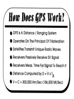
How Does GPS Work?
How the Global Positioning System works is, conceptually, really
very simple. All GPS is, is a distance (ranging) system. This means that
the only thing that the user is trying to do is determine how far they are
from any given satellite. There is no inherent vector information, which
implies azimuth (compass direction) and elevation, in the GPS signal. All
that the GPS satellite does is shoot out a signal in all directions, although
there is a preferential orientation towardthe Earth.
In essence, the GPS operates on the principle of trilateration. In
trilateration, the position of an unknown point is determined by measuring
the lengths of the sides of a triangle between the unknown point and two
or more known points (i.e., the satellites). This is opposed to the more
commonly understood triangulation, where a position is determined by
taking angular bearings from two points a known distance apart and
computing the unknown point’s position from the resultant triangle.
The satellites do this by transmitting a radio signal code that is
unique to each satellite. Receivers on the ground passively receive each
visible satellite’s radio signal and measures the time that it takes for the
signal to travel to the receiver. Distance is then a simple matter of comput-
ing D = V x T, or deriving distance (D) by multiplying the time in transit
(T) of the signal by the velocity of transit (V). This is the old “if a car
travels a 60 mph, how far will it travel in two hours?” Since radio waves
travel at the speed of light, which is essentially fixed at 300,000 kilome-
ters per second, the velocity is a given. Therefore, the only thing needed
by the user to calculate distance from any given satellite is a measurement
of the time it took for a radio signal to travel from the satellite to the
receiver.
33
Two- Way vs. One- Way Ranging
The two diagrams to the left illustrate common examples of the two
principal types of ranging, One-Way Ranging and Two-way Ranging, that
most of us are familiar with.
We’ve all seen those WWII submarine movies where the SONAR
(SOund
NAvigation and Ranging) man intently listens to the “Ping, Ping,
Ping” of the destroyer above that is trying to locate and sink the sub.
While this is seldom done anymore, it serves well to illustrate the concept
of two-way ranging. In the case of the diagram at
left,
the submarine sends
out a unique and recognizable sound (the “ping”) and measures the time
it takes to reach something (in the diagram, the sea floor) and bounce back
up to the listener. Essentially, the listener is listening for and timing the
echo. The listener knows how fast the sound travels through the water and
so can quickly and easily calculate how far away that something (the sea
floor) is. More contemporary examples can be seen in modern EDM’s
(Electronic Distance Measuring equipment) which measure how far away
something is by bouncing either a laser beam or, in some cases, sound
waves, off of it and measuring the time it takes to return.
The second diagram illustrates the concept of one-way ranging in
a way that most of us are familiar with-the thunderstorm. We know that
by counting the seconds that it takes for the thunder to reach us after the
flash of lightning, we can determine how far away the storm is. We know
that it takes about five seconds for sound to travel one mile and we know
precisely when the lightning occurred. Even though the light from the
lightning does take a finite span of time to reach us, considering how
(relatively) close the storm is and how fast light travels, for all intents and
purposes, we see the flash the instant it occurs. This is, conceptually, how
GPS works. The difference is that GPS measures radio-wave transit time
rather than sound.
35