Tài liệu Báo cáo " Spatial organization for rational land use and environmental protection in Uong Bi Town by functional sub-areas" docx
Bạn đang xem bản rút gọn của tài liệu. Xem và tải ngay bản đầy đủ của tài liệu tại đây (572.13 KB, 8 trang )
VNU Journal of Science, Earth Sciences 23 (2007) 88-95
88
Spatial organization for rational land use and
environmental protection in Uong Bi Town
by functional sub-areas
Truong Quang Hai*
Institute of Vietnamese Studies and Development Sciences, VNU
Received 05 February 2007
Abstract. Spatial or territorial organization is one of effective tools for sustainable land use. Spatial
organization of land use and environmental protection by functional sub-areas is performed on the
basis of comprehensive and integrated research on characteristics and differentiation laws of
natural components and landscapes, socio-economic factors, the present status and trend of
environmental changes as well as the structures and functions of sub-areas.
Uong Bi is a national center for tourism, coal mining and thermal power production. The
development of economic sectors has led to a series of urgent environmental and social problems,
requiring implementation of plans and solutions for ensuring sustainable development. This paper
proposes a scientific-based spatial organization of land use and environmental protection by eight
functional sub-areas in the Uong Bi Town area.
Keywords: Spatial organization; Land use; Environmental protection; Territorial zoning; Uong Bi Town.
1. Introduction
*
Land as the space for living and production
activities is an extremely valuable resource, and
an important component of the environment.
Territorial organization of land use and
environmental protection is coordinated
arrangement of land uses in the multi-sectoral
relationship, combining the economic
development with environmental protection,
with the aim to use natural and socio-economic
potentials efficiently, prevent pollution and
improve the environment quality [1, 2].
_______
*
Tel.: 84-4-5571338.
E-mail:
The Uong Bi Town is the western gateway
of Quang Ninh Province, a junction for economic
and commercial exchanges in the corridor of
National highways No 10 and 18, which is a key
economic area of Quang Ninh Province.
The Uong Bi Town area has rather rich
mineral resources, consisting of coal (690
million tons), limestone (28-30 million tons),
claystone (595,000 tons), and forest resources
(10,736 ha), high potential tourism resources
with Yen Tu tourist center, Lung Xanh waterfalls,
Yen Trung reservoir. These are considered very
important resources, contributing to the
economic development of the town. However,
the development of economic sectors, especially
mining, thermal power generation, etc., has led
to a series of pressing issues in terms of
Truong Quang Hai / VNU Journal of Science, Earth Sciences 23 (2007) 88-95
89
environment and society. The immediate and
long term problem of Uong Bi is that concrete
measures and action plans are required not
only for sustainable economic growth, but also
for ensuring environmental quality and social
stability. For this very reason it is necessary to
organize the space for rational land use and
environmental protection of Uong Bi Town in
the direction of sustainable development.
2. Data and research methods
2.1. Approaches to spatial organization research
The systems approach and sustainable
development approach are the leading
methodology in the territorial organization of
land use and environmental protection.
A system is an assemblage of factors
interacting with each other and with the
environment through the material and energy
flow. Any system is a component of a higher
level system. Between those systems exists a
mutual relationship. Each system is structurally
complete and functionally unified. Therefore,
when acting on a component of a system, its
other components also change, leading to
changes in the system as a whole.
The territory of Uong Bi as a geosystem
formed by a mutual relationship between
natural factors (geologic, topographic, climatic,
hydrologic, pedologic, biologic, etc.), socio-
economic factors and forms of exploitation and
use of natural resources (industrial, agricultural
production, etc.). This system is structurally
complete and functionally unified: economic,
administrative, ecologic, social, and other
functions).
The sustainable development approach
requires a harmonic combination between socio-
economic development and environmental
protection, in particular it requires to implement
three objectives: (1) effective economic
development, (2) harmonic development of
social aspects, improvement of living standards
of the population and (3) prevention of
pollution and improvement of the ecological
environment.
2.2. Data for spatial organization
The data sources serving territorial
organization of land use and environmental
protection consist of geomorphologic, pedologic,
climatic, hydrologic, vegetation cover, statistical
and socio-economic survey data of the whole
Uong Bi Town and its wards, communes in
2004, 2005, 2005; water and air environment
analysis data from pilot research sites collected
in the rainy and dry seasons from 2004 to 2006;
a series of 1: 25,000 scale geomorphologic,
pedologic, and land use status, vegetation cover,
population distribution, general economic,
environmental quality status maps, natural
hazards, environmental zoning maps of Uong
Bi Town.
2.3. Research procedure and methods
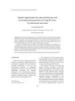
The procedure for territorial organization
research of Uong Bi Town consists of two large
steps [3, 4] (Fig. 1): (1) Survey, analysis and
evaluation of natural, socio-economic and
environmental conditions of Uong Bi Town; (2)
Orientation of spatial organization by sub-areas
and recommendations of solutions for
implementation.
The main research methods used include:
Field survey; Sample analysis for environmental
components; Mapping, remote sensing and GIS.
Integrated and inter-disciplinary surveys were
conducted along traverses across the main
types of landforms and characteristic production
areas of Vang Danh, Nam Mau coal mining
areas, Yen Tu tourist area, the aquacultural area
in the south of the town, etc.), the main
population area at the center of the town. Soil,
water and air samples were analyzed for
evaluating the status, spatial and temporal
variation of the environmental quality in the
study area.
Truong Quang Hai / VNU Journal of Science, Earth Sciences 23 (2007) 88-95
90
Analyzing the
economic,
ecological, social
and environmental
functions of each
sub-area (II.1)
Proposing measures for implementing
spatial organization in land use and
environmental protection for each sub-area
(II.5)
Evaluation of natural
conditions, natural resources
(I.1)
Analysis of current status of
socio-economic development
(I.2)
Analysis of environmental
status and natural hazards in
the area (I.3)
Territorial zoning (I.4)
Analyzing and predicting
urgent natural resources and
environmental issues for
each sub
-
area (II.3)
Proposing orientation for spatial
organization in land use and
environmental protection (II.4)
Analyzing socio-
economic
development
orientation
(II.2)
Step
1
Step 2
Fig. 1. Research procedure for spatial organization of land use and environmental protection in Uong Bi Town.
The mapping, remote sensing and GIS
methods were used in various stages in the
research process, with the aim to present the
distribution and relationship between natural,
socio-economic components in the territory of
Uong Bi Town. In the research process, SPOT 5
space images with resolution of 2.5 m and
various software programs (Mapinfo 7.8,
ArcGIS 9.0) were used for compiling thematic
maps and territorial organization maps of land
use and environmental protection.
3. Spatial organization of land use and
environmental protection
3.1. Territorial zoning of Uong Bi Town
Zoning of Uong Bi Town is essentially
dividing this area into sub-areas with particular
natural, socio-economic and environmental
characteristics.
Sub-area is a particular territorial unit
which is considered a geosystem consisting of
relatively homogeneous natural conditions,
socio-economic activities which have mutual
interactions creating specific characteristics
allowing to orient for exploitation and use of
natural resources and environmental
protection.
Research and evaluation of these sub-areas
will create a scientific basis for planning the
economic development attached with the
rational exploitation and utilization of natural
resources and environmental protection in the
direction of sustainable development.
Each sub-area is delineated based on the
Truong Quang Hai / VNU Journal of Science, Earth Sciences 23 (2007) 88-95
91
following characteristics:
• Relative uniformity in terms of natural
conditions (geology, geomorphology, climate -
hydrology, soil-vegetation);
• Specific characteristics in terms of
economic development, exploitation and use of
natural resource (mining, forms of land use,
degree of urbanization and industrial
development, rural areas and agricultural,
forestry and fishery development);
• Assemblage of urgent environmental
problems and natural hazards.
Although each sub-area has particular
characteristics in terms of groups of natural,
socio-economic and environmental factors, the
names of sub-areas are usually attached with
their geographic names and functions for easy
identification of their spatial distribution,
characteristics, role and functions.
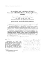
Based on the above indicators, the study
area is divided into 4 groups of sub-areas
consisting of 8 sub-areas (Fig. 2).
3.2. Spatial organization of land use and
environmental protection by sub-areas
Based on the results of research on
structures and functions of sub-areas, analysis
of the current status and the trend of socio-
economic development, regional environmental
evolution, combined with the consideration of
orientation for development of Uong Bi area
and Quang Ninh Province, a spatial organization
of land use and environmental protection by
sub-areas has been proposed.
• Yen Tu tourist and medium mountain forest
landscape conservation sub-area
This is an area with medium height, steep
slope mountains of Yen Tu mountain range.
The landform in this sub-area is developed on
coarse grained sedimentary rocks, consisting of
alternating layers of conglomerate, gritstone,
sandstone, claystone and coal seams of Hon Gai
formation. The soil here is of feralite type, of
yellowish red color, with rather high humus
content, vulnerable to erosion and acidification.
This is an area of close, ever green, humid
subtropical forest with broad leaf trees (mixed
with some conifer trees), with many species of
precious timber trees, valuable medicinal herbs,
beautiful flowers.
The Yen Tu historical - cultural site is a
national Buddhist Center, a special natural
beauty spot. The conversion of Yen Tu area into
a large scale cultural - ecological tourist site
brings great socio-economic benefit, but on the
other hand it also causes great pressures on the
environment, especially in the festival season.
Therefore it is necessary to preserve and
refurbish historic and cultural relics, protect the
natural landscape of the beauty spot, especially
the forest cover along the tourist route; adopt
strong sanctions to prevent illegal exploitation
of timber, medicinal herbs and other non-
timber forest resources.
• East Yen Tu - Bao Dai low mountain and hill
forestry sub-area
The northern part of this sub-area is
characterized by medium mountains composed
of coarse grained terrigenous rocks of Hon Gai
formation. The topography here is of high slope,
strong dissection. Here occurs a well preserved
primary forest cover, where originates the
system of rivers and streams flowing to Uong Bi
Town. The main function of this sub-area is to
protect the watershed forest, contributing to the
regulation of surface water flow and
improvement of the ecological environment.
The southern part of this sub-area is of low
mountain topography, composed of volcano-
sedimentary rocks of Binh Lieu formation. This
is where originate most of streams flowing into
the Sinh River and Vang Danh stream in
Thuong Yen Cong population and agricultural
sub-area. It is crossed by the Yen Tu tourist
route, therefore the vegetation cover here has
been strongly impacted. Besides the secondary
forests there are humid tropical secondary
scrubland savannas. Here priority should be
given to the forest zoning and regeneration, soil
protection and erosion control.
Truong Quang Hai / VNU Journal of Science, Earth Sciences 23 (2007) 88-95
92
Fig. 2. Sub-areas of Uong Bi Town for spatial organization of land use and environmental protection.
• Vang Danh coal mining sub-area
The vast mining sites of Vang Danh,
Vietmindo and Nam Mau coal companies to the
NE of Uong Bi Town. The extent and output of
coal mining are increasing for both open pit
and underground mines. Coal mining brings
big economic benefits, but impacts strongly the
land and forest resources, causes ever more
serious environmental pollution in the mining
area and the surroundings. Coal mining is the
greatest source of environmental pollution in
the area of Uong Bi Town. It is necessary to
perform well and in time the land rehabilitation
and reforestation, plan appropriate coal mining
waste dumps.
In the area of the coal processing plant
appropriate technological solutions must be
used for treatment of the waste water from the
coal processing, reducing dust and noise.
• Thuong Yen Cong valley and gentle hill
populated and agricultural production sub-area
The topography of this sub-area consists
mainly of tectonic valley, structural- denudation
types with accumulative-denudation and delta
margin landforms, composed mainly of coal
bearing terrigenous sediments. In the sub-area
are formed the main soil types: colluvial soil,
sterile alluvial soil, and yellow feralite soil on
Truong Quang Hai / VNU Journal of Science, Earth Sciences 23 (2007) 88-95
93
sandstone. The soils are in general rich in
nutrients, tend to be acidified (pH = 4 ÷ 4.5).
With the relatively gentle topography, the
water from the Sinh River and the Uong River
can be used for agricultural development. The
colluvial and alluvial soils are favorable for
cultivation of rice and dry crops. On the other
hand, this sub-area is crossed by National road
No 18B in E-W direction, so it is the favorable
for population settlement and agricultural
development in comparison with the other sub-
areas in the mountain area north of the Uong Bi
Town.
For the Thuong Yen Cong rural and
agricultural development priority area, priority
is given to rice cultivation to ensure food
supply to the population, fruit trees and
vegetable growing to serve tourists in Yen Tu
during the spring festivals and the population
of Vang Danh Ward.
Agricultural and forestry cultivation
models on the plain marginal hills and tectonic
valleys which bring high economic efficiency
and maintain the ecological sustainability should
be established: an appropriate cultivation
technique should be used, the soil quality
should be protected and improved, soil erosion
and wash-off should be prevented.
The Vang Danh urban and service area is
the main living area of the population in Vang
Danh Ward and most miners' households, with
many restaurants, trade and service
establishments. The environmental issues given
priority for solution include: clean water supply
and domestic waste water treatment, collection
and disposal of domestic wastes.
• Central low mountain and hill forestry and
ecotourist sub-area
This sub-area is mainly of low mountain
and hill landforms on coal bearing terrigenous
sediments, together with some other types of
landforms such as plain marginal hills
composed of coal bearing terrigenous sediments,
erosion-tectonic valleys with hummocky
topography formed by dissection of terraces
and pediments. The soil cover consists mainly
of yellow red or yellow gray feralite soil on
sandstone. In this sub-area occurs mainly close,
humid tropical board leaf, ever green forest
type with predominance of wood trees and
secondary humid tropical shrubs.
The main function of this sub-area is to
develop forestry, build reservoirs, ensuring
sufficient clean water for domestic water
supply and for production in Vang Danh Ward.
The Yen Trung reservoir area should be
built as an ecological tourist and resort area
with protection, restoration and planting of
pine forest. The waste water treatment and the
collection of solid wastes from tourist area
should be properly conducted.
Construction of a dam across the Sinh River
and Muoi Hai Khe stream to create a multi-
purpose reservoir is a strategic turn for
domestic water supply in Uong Bi Town [5].
Full use of the beautiful scenery of the reservoir
area should be made for developing ecotourism
and resorts, but special attention should be paid
to the protection of the water environment in
the reservoir.
The forest cover upstream of the reservoirs
must be strictly protected to ensure constant
water supply sources for the reservoirs even
during the dry season, contributing to the
reduction of soil erosion, suspended solids
contents in the river and stream water and
sedimentation in the reservoir.
The landscape of this sub-area is being
impacted by human activities as it is located
adjacent to National road 18B and crossed by
coal hauling roads from Vang Danh coal mine
to Dien Cong port. The vegetation cover
consists mainly of secondary shrubs and
planted forests. The soil cover in many places is
strongly eroded, exposing bed rock. For this
sub-area, priority is given to the zoning of
forest for regeneration, forest planting, soil
protection, erosion control.
Truong Quang Hai / VNU Journal of Science, Earth Sciences 23 (2007) 88-95
94
• Central urban and industrial sub-area
The industrial part of this sub-area has high
population density with concentration of
industrial production. To improve the quality
of environment it is necessary to restrict
construction of new industial facilities here. The
most urgent environmental issue in this sub-
area is the industrial and municipal waste
management. Appropriate technilogies must be
used for mitigating the pollution due to gas
emission from the thermal power plant,
treatment of industral waste water, close
management of solid industrial wastes,
especially hazardous wastes.
The urban part of this sub-area has diverse
sources of industrial and domestic wastes,
which have caused local environmental
pollution. Urgent environmental issues to be
solved include: ensuring sufficient clean water
suply for the urban population; planning for
collection and treatment of waste water from
domestic activities and from service
establishments, market places, retaurants;
collection and full disposal of hazardous wastes
from the hospitals, health care facilities in the
urban area of the town and dispersed industrial
facilities; classifying solid wastes at the source
and establishing new waste collection stations,
performing good collection and disposal of
urban wastes; planning and building new
recreation grounds and parks, developing
spaces such as greeneny areas, etc.; taking
measures to closely manage the transportation
of fill and construction materials for
implementing construction projects.
• Southern new industrial, commercial and
urban sub-area
This sub-area is characterized by low-land
marine-alluvial accumulative plain landform.
Here are concentrated agricultural, fishery,
forestry activities of tidal area, operation of the
coal terminal and implementation of industrial,
commercial and new urban development
projects. The main environmental issues of this
sub-area are air pollution, noise, water
pollution due to transport activities, construction
projects and development of population areas.
Besides, waste water treatment and
rehabilitation, upgrading and construction of
water supply and drainage systems are also
important issues raised for this sub-area.
It is necessary to promote integrated
development of industrial and commercial
areas concentrated along National roads No 10
and 18A taking into consideration the space for
development of the new urban area, making
use of the advantage in terms of position and
privileged investment policy to help the
development of the sub-area and create jobs for
the local people; closely managing the
construction of infrastructures; taking measures
for mitigating dust and gas emission by means
of transport carrying fill and construction
materials for construction projects along the
roads; closely controlling the discharge of waste
water from factories, commercial areas,
mitigating their impacts on the environment,
especially water environment.
• South Uong Bi agricultural, fishery and port
economy lowland plain sub-area
This sub-area is a strip of low-lying
accumulation plain of fluvio-marine genesis
along the sides of Da Bac River. The elevation
combined with strong effect of the tides led to
the formation of an acidic and saline soil cover.
The soil is of low humus, total and available
NPK contents and relatively high Cl content.
The vegetation cover is mainly halophilous and
acidophilous flora.
Commercial agriculture should be
developed on the land side of the dike and
aquaculture should be developed sustainably
on the river side. Environmental sanitation
should be well carried out in the population
clusters in the low-lying plain along the river
sides. The residual limestone mountains in the
low-lying plain along Hang Ma and Da Bac
rivers, which form charming landscapes,
Truong Quang Hai / VNU Journal of Science, Earth Sciences 23 (2007) 88-95
95
require investment for development of
ecotourism and resorts.
The Dien Cong coal terminal and Bach Thai
Buoi integrated terminal need to be upgraded
in size and application of appropriate technical
measures to prevent water and air pollution
caused by coal transportation.
The coal hauling routes start at mining sites
of Vang Danh, Vietmindo, Nam Mau coal
companies and end at Dien Cong coal terminal.
The coal hauling railway and road
infrastructures are in bad condition and need to
be upgraded to meet the increasing demands of
coal extraction and transportation in coming
years. Greenery corridors with a width of 20 -
30m should be established along the roads to
minimize the air pollution and improve the
climatic condition in the area.
4. Conclusions
Territorial organization is one of effective
solutions for management and rational use of
land resources toward sustainable development.
A spatial organization of rational land use
and environmental protection of Uong Bi Town
area has been proposed on the basis of
structural-functional analysis of sub-areas, with
special attention paid on the economic and
environmental functions.
Based on the characteristics of natural,
socio-economic conditions, the present status
and trend of environmental changes, the Uong
Bi area is divided into 4 groups of sub-areas
consisting of 8 sub-areas: Yen Tu tourist and
medium mountain forest landscape
conservation sub-area, East Yen Tu - Bao Dai
low mountain and hill forestry sub-area, Vang
Danh coal mining sub-area, Thuong Yen Cong
valley and gentle hill populated and
agricultural production sub-area, Central low
mountain and hill forestry and ecological
tourist sub-area, Central urban and industrial
sub-area, Southern new industrial, commercial
and urban sub-area, South Uong Bi agricultural,
fishery and port economy lowland plain sub-
area.
Acknowledgements
This paper was completed within the
framework of Fundamental Research Project
703106 funded by Vietnam Ministry of Science
and Technology.
References
[1] M.M. William, Landscape Planning: Environmental
Applications, third edition, John Wiley, Sons, Inc.,
USA, 1997.
[2] N.D. Vinh, Strategic Research and Planning for
Socio-economic Development in Vietnam – Learning
and Creation, National Politics Publishing
House, Hanoi, 2003 (in Vietnamese).
[3] N.C. Huan, A Spatial Organization Study for
Economic Development, Rational Utilization of
Natural Resources and Environmental
Protection at Provincial and District Level (case
study of Lao Cai Province), VNU Journal of
Science, Natural Sciences and Technology No. 4 /
XX (2004) 55 (in Vietnamese).
[4] T.Q. Hai, N.C. Huan, D.V. Bao, Territorial
Organization for Ecotourism Development at
Provincial Level, VNU Journal of Science, Natural
Sciences and Technology No. 4AP / XXII (2006) 58
(in Vietnamese).
[5] N.C. Huan, D.V. Bao, T.Q. Hai, H.D. Son, T.T.
Ha, N.A. Thinh, T.V. Truong, Study on Water
Supply Planning for Uong Bi Town until 2020,
VNU Journal of Science, Natural Sciences and
Technology No. 4AP / XXII (2006) 96 (in
Vietnamese).