Tài liệu Báo cáo " Mechanism of forming the Dien Bien basin " pdf
Bạn đang xem bản rút gọn của tài liệu. Xem và tải ngay bản đầy đủ của tài liệu tại đây (162.4 KB, 4 trang )
VNU Journal of Science, Earth Sciences 23 (2007) 76-79
76
Mechanism of forming the Dien Bien basin
Chu Van Ngoi*, Luong Thi Thu Hoai
College of Science, VNU
Received 12 March 2007
Abstract. The Dien Bien basin in the Northwest of Vietnam is the largest one of the pull-apart
basins related to the Dien Bien - Lai Chau fault zone. This basin, orientated from the north to the
south, is 21km long, 6-8km wide and rhomboidal in shape. The process of forming this basin is
related closely to the activities of the Dien Bien - Lai Chau fault zone in Neotectonic time. On
analyzing information concerning the kinematics of the Dien Bien - Lai Chau fault zone, the
geological structure and the sediments of the basin, we suppose that the Dien Bien basin is a splay
pull-apart one related to the movement of the Dien Bien - Lai Chau fault zone in Pliocen-
Quaternary time. The determination of the mechanism of forming the Dien Bien basin is important
to specify Neotectonic activities of the Dien Bien - Lai Chau fault zone.
Keywords: Active tectonics; Dien Bien - Lai Chau fault zone; Pull-apart basins; Quaternary.
1. Introduction
*
The Dien Bien basin, 21km long and 6-8km
wide, is an important political, economic and
cultural center of the Northwest region of
Vietnam in general and of the Dien Bien
Province in particular. In geological respect, the
Dien Bien basin is a small, narrow, rhomboidal
pull-apart basin, stretching along the Dien Bien
- Lai Chau fault zone, which is more than
160km long, 6-10km wide, and is the most
seismically active fault zone in Indochina.
Being an important center of the Northwest
region of Vietnam, the Dien Bien basin has been
studied in detail for many years. However, the
dynamic model of forming this basin is still a
knotty question for scientists who study the
movement of the Dien Bien - Lai Chau fault
_______
*
Corresponding author. Tel.: 84-4-5587060.
E-mail:
zone in Neotectonic time.
In this paper, the authors have analyzed the
data about the Dien Bien - Lai Chau fault zone
activities, the geological structure of the basin,
as well as the theory of basin-forming regime to
figure out the mechanism of formation and
development of this basin.
2. Activity of the Dien Bien – Lai Chau fault
zone in Neotectonic time
During Neotectonics, the geological
structure of the Northwest region of Vietnam is
controlled by 2 fault zones: the Red River fault
zone in the northeast and the Dien Bien - Lai
Chau fault zone in the west.
Since Pliocene, the collision of the Indian
plate to Eurasia plate had produced a stress
field with
1
σ
in N – S direction and
3
σ
in E – W
Chu Van Ngoi, Luong Thi Thu Hoai / VNU Journal of Science, Earth Sciences 23 (2007) 76-79
77
direction [1]. This stress field caused the
displacement on all of the active faults in this area.
The Dien Bien - Lai Chau fault zone is one
of the most active fault zones in Indochina. This
fault zone is a part of the Lai Chau – Luong Pha
Bang – Pursat fault system, extending from the
border between China and Vietnam from the
north, to the Gulf of Thailand in the south. In
the Northwest region of Vietnam, this fault is
about 160km long and 6-8km wide, orientated
north-south, starting from Chieng Chai (Lai
Chau) to Tay Trang Pass (Dien Bien) and
characterized by left-lateral regime in Pliocene-
Quaternary time [1].
Morphologically, Dien Bien - Lai Chau fault
zone has en-echelon structure with a major
fault in the center of the zone and several
secondary faults in the south. The fault zone
cuts through Proterozoic, Paleozoic and
Mesozoic sedimentary and metamorphic rocks,
also Paleozoic and Triassic granitoids. Along
the Dien Bien - Lai Chau fault zone, there are
some small basins. The Dien Bien - Lai Chau
basin, located in the south, is the largest one.
Within Dien Bien basin, there is some
olivine basalt exposed along the main fault in
Doc Lap hill, Tom village, Muong Thanh
airport [2]. The olivine basalt is also found in
borehole at the depth of 160m in the central
part of basin. This is a product of tectonic
activities of the Dien Bien - Lai Chau fault zone
in Pliocene-Quaternary time and is one of the
bases for determining age of Dien Bien basin.
The movement on the Dien Bien - Lai Chau
fault zone also led to form several secondary
faults. These secondary faults are expressed
clearly in the electronic and seismological cross-
sections [3].
The electronic cross-sections show 4
secondary faults in the Quaternary deposits of
the Dien Bien basin. They are divided into 2
groups: the first, located near the Nam Rom
river bank, is steeper and dipping eastward; the
second, located near the basin center, is gentler
and dipping westward. Between these 2 groups
there is a brittle deformation zone which is
subsided and covered by unconsolidated
Quaternary sediments.
3. Geological structure and formation of the
Dien Bien basin
The geological structure of the Dien Bien
basin is composed of 2 main parts: the
basement consists of Triassic sedimentary
bedrock and the cover consists of Neogene-
Quaternary formations. The basin floor has an
unsymmetrical "V" shape: the west side is
steeper and the east side is gentler.
- The basement composed of conglomerate,
gritstone, grading upward to black-grey
claystone, siltstone, small-grained sandstone
bearing. The bedrock is brittle shattered and
pulverized. Some members are folded.
According to the electronic and seismological
cross-sections, there is a shattered zone
developed along the long axis of the basin. The
rock of the east side has been broken much
more than that of the west side.
- The cover composed of olivine basalt and
loose sediments:
+ The Late Neogene basalt erupted as a
chain of olivine, pyroxene basalt stretching
along the axis of the basin. The sample taken
from drill hole shows that the mineral
composition of basalt mainly includes olivine
and pyroxene, rarely quartz. This basalt has a
blue-grey color and is very stable. Its thickness
reaches about 100m. When the rock is
weathered, the color is changed into red-grey
and the weathering basalt layer reaches 2.5-10m.
+ The Quaternary loose sediments are
mainly fluvial sediments which are divided
into 3 layers. The first one is composed of
boulder, pebble, grit mixed with light-grey silt
and clay. Pebbles are well rounded and sorted
with the main composition of quartz. The
Chu Van Ngoi, Luong Thi Thu Hoai / VNU Journal of Science, Earth Sciences 23 (2007) 76-79
78
second one is composed of pebble, granule,
sand and boulder in the low part, silt, clay
mixed with some sand layers in the upper part.
The last one is composed of pebble, granule
mixed with silt and clay.
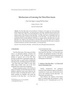
4. Mechanism of forming the Dien Bien basin
Based on analyzing the activities of the
Dien Bien - Lai Chau fault zone and the
geological characteristics of the Dien Bien basin,
the process of formation of the Dien Bien basin
is figured out as follows:
In early Pliocene, as a consequence of the
collision Indian plate to Eurasia plate, the South
China block was drifted and moved to the
southeast as the displacement along the Red
River fault and the Indochina block was drifted
northward. The Dien Bien - Lai Chau fault and
the Sop Cop - Lang Chanh fault were reactivated
with the opposite strike slip regime: Dien Bien -
Lai Chau fault was left-lateral and Sop Cop -
Lang Chanh was right-lateral one, producing
an extensional field, associating secondary
faults.
The secondary faults played a role of the
channel system for the olivine basalt eruption.
After the basalt eruption, the weathering
process and the subsidence process to form the
Dien Bien basin started.
On the west side of the basement, the
subsidence may take place so quick that the
basement slope is steeper and the bed rock is
more stable. In turn, on the other side the
bedrock was subsided progressively because it
is fairly far the major fault. As a result, the
basement slope is gentler. This process formed
the unsymmetrical "V" shape of the basement.
As the subsidence processing, the
sedimentary process happened and reaches to
the sediment thickness of some 5-160m.
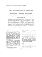
The above proofs lead us to conclude that
the Dien Bien basin was formed as a Splay pull-
apart basin [4].
5. Conclusions
1. The Neotectonic movement of Dien Bien -
Lai Chau fault zone and of Sop Cop - Lang
Chanh fault plays an important role in forming
the Dien Bien basin.
Fig. 1. Diagram illustrating the mechanism of forming the Dien Bien basin.
Chu Van Ngoi, Luong Thi Thu Hoai / VNU Journal of Science, Earth Sciences 23 (2007) 76-79
79
2. The geological structure of Dien Bien
basin is divided into 2 parts: the basement is
composed of deformed Triassic sediment; and
the cover consisted of olivine basalt and loose
fluvial sediment.
3. Morphological structure and the
developmental history of the Dien Bien basin
clearly expresses that the Dien Bien basin was
formed by Splay pull-apart regime.
References
[1] N.V. Hung, Characteristics of the neotectonic faults
in NW Vietnam, Ph.D thesis, Institute of Geology,
VAST, Hanoi, 2002 (in Vietnamese).
[2] Ministry of Heavy Industry, Ministry of
Construction, General Department of Geology,
Report on investigation of the geological
characteristics of Dien Bien City, Hanoi, 1994 (in
Vietnamese).
[3] D.V. Toan, D.V. Tuyen, Applying resistance-
electric method on studying geological characteristics
in Dien Bien Valley, Institute of Geology, VAST,
Hanoi, 2001 (in Vietnamese).
[4] M. Williams, T. Hathaway, Structural geology
workshop, Robertson Petroleum Training Centre,
1997.