Bell & Howell Information and Learning 300 North Zeeb Road, Ann Arbor, MI 48106-1346 USA 800-521-0600UMI.The Potential of Soil Survey Data in a Quantitative Evaluation of Surficial Geology Mapping in Northern Maine by Rosalia EvansThesis submitted t pptx
Bạn đang xem bản rút gọn của tài liệu. Xem và tải ngay bản đầy đủ của tài liệu tại đây (2.44 MB, 131 trang )
Bell & Howell Information and Learning
300 North Zeeb Road, Ann Arbor, MI 48106-1346 USA
800-521-0600
UMI
The Potential of Soil Survey Data
in a Quantitative Evaluation of Surficial Geology
Mapping in Northern Maine
by
Rosalia Evans
Thesis submitted to the
Eberly College of Arts and Sciences
at West Virginia University
in partial fulfillment of the requirements
for the degree of
Master of Arts
in
Geography
J. Steven Kite, Ph.D., Chair
Daniel Weiner, Ph.D.
Gregory Elmes, Ph.D.
Department of Geology and Geography
Morgantown, West Virginia
2002
Keywords: geographic information systems, soil surficial geology relationships,
soil survey potential applications, surficial geological mapping, Maine.
Copyright 2002 Rosalia Evans
v
TABLE OF CONTENTS
Abstract
ii
Dedication iii
Acknowledgements iv
Table of contents v
List of figures vi
List of tables vii
Introduction 1
Purpose 5
Research objectives 7
Study areas 8
Previous research 11
Research materials and methods 14
Soil survey data 14
Converting soil mapping units to geologic units 22
Soil-surficial geology framework development 25
Prescott’s map data 27
Analysis of Prescott’s map data 28
Genes’s map data 31
Analysis of Genes’s map data 33
Kite’s point observations 35
Analysis of Kite’s point observations 37
GIS overlay results 42
Kite’s point data compared to the derivative map’s classifications 42
Kite’s point data compared to Prescott’s surficial geology map 46
Kite’s point data compared to Genes’s surficial geology maps 48
Prescott’s map units compared to the derivative map’s classifications 50
Genes’s map units compared to the derivative map’s classifications 51
Analysis of Kite’s point data compared to Prescott, Genes, and the derivative map 52
Analysis of the derivative map compared to Kite, Genes, and Prescott 55
Conclusion 73
Bibliography 80
APPENDIX 1 Soil series descriptions 83
APPENDIX 2 Kite’s surficial geology data at the 248 point stations 93
APPENDIX 3 The origin of Kite’s point data compared to the derivative map 99
APPENDIX 4 Kite’s point data compared to Prescott’s mapped units 104
APPENDIX 5 Kite’s point data compared to Genes’s mapped units 109
APPENDIX 6 Derivative map’s classifications compared to Genes’s mapped units 114
APPENDIX 7 Derivative map’s classifications compared to Prescott’s mapped units 119
APPENDIX 8 Till, alluvium, and ice-contact stratified drift classifications on the derivative map
versus Kite, Genes, and Prescott according to textural differences 124
vi
LIST OF FIGURES PAGE
1 Northern Maine study areas 6
2 Soil survey sheets in the northern Maine study areas 10
3 Electronically produced derivative map compiled from soil survey data 19
4 Prescott’s map produced electronically 29
5 Genes’s maps produced electronically 32
6 Kite’s point observations produced electronically 36
7 Maine geological surficial data sheet 38
vii
LIST OF TABLES PAGE
1 Parent materials associated with particular soils in the St. John River Valley,
northern Maine 3
2 The 73 soil mapping units and associated slope 15
3 Soil series arranged according to drainage catenas 17
4 The RMS (root of the means squared) achieved through the digitization, and the
calculated meters error on the ground for the 17 soil survey sheets 21
5 Area and percentage of area of surficial geology map units on the derivative surficial
geology map derived from soil surveys 30
6 Area and percentage of area of surficial geology map units on portions of Prescott’s
ground-water favorability map 30
7 Area and percentage of area of surficial map units on portions of Genes’s Fort Kent
Stockholm, Van Buren, and Eagle Lake quadrangles 34
8 Descriptions of the landforms upon or in which Kite’s point observations are located 39
9 The origins of Kite’s data at the 248 point stations 39
10 Sub-categories of Kite’s, Prescott’s, Genes’s, and the derived map’s surficial geology
combined for comparison purposes 41
11 Kite’s point data compared to the derivative map’s surficial geology classifications 43
12 Agreement between Kite’s point data and the derivative map’s classifications 43
13 Kite’s point data compared to Prescott’s surficial geology 47
14 Agreement between Kite’s point data and Prescott’s mapped units 47
15 Kite’s point data compared to Genes’s surficial geology 49
16 Agreement between Kite’s point data and Genes’s mapped units 49
17 Prescott’s map compared to the derivative map at Kite’s point locations 51
18 Agreement between the derivative map and Prescott’s map 50
19 Genes’s map compared to the derivative map at Kite’s point locations 51
20 Agreement between the derivative map and Genes’s map 52
21 The probability till mapped by Genes and Prescott, and classified on the derivative
map is interpreted by Kite as the same 54
22 The probability alluvium mapped by Genes and Prescott, and classified on the
derivative map is interpreted by Kite as the same 54
23 The probability ice-contact stratified drift mapped by Genes and Prescott,
and classified on the derivative map is interpreted by Kite as the same 54
24 The probability till, ice-contact stratified drift, and alluvium mapped by Genes and
Prescott, and classified on the derivative map is interpreted by Kite as the same 55
25 The probability till mapped by the geologists is classified on the derivative map
as the same 56
26 The probability ice-contact stratified drift mapped by the geologists is classified
on the derivative map as the same 56
27 The probability alluvium mapped by the geologists is classified on the derivative
map as the same 57
28 The probability till, ice-contact stratified drift, and alluvium mapped by the geologists
is classified on the derivative map as the same 57
29 The probability till, ice-contact stratified drift, alluvium, swamp, and outwash mapped
by the geologists is classified on the derivative map as the same 57
30 Soil series arranged according to drainage catenas showing Kite versus the
derivative map 58
31 Soil series arranged according to drainage catenas showing Prescott versus the
derivative map 62
32 Soil series arranged according to drainage catenas showing Gene versus the
derivative map 63
viii
LIST OF TABLES PAGE
33 The well drained soil series showing the geologists versus the derivative map 77
34 The moderately well drained to somewhat poorly drained soil series showing the
geologists versus the derivative map 78
35 The poorly to very poorly drained soil series showing the geologists versus
derivative map 64
36 The probability till, ice-contact stratified drift, swamp, outwash, and glacial lake
deposits mapped by Genes and Prescott, and classified on the derivative map are
interpreted by Kite as the same 79
37 Kite’s till interpretations arranged according to percent of slope compared to the
derivative map’s till classifications 65
38 Gene’s till interpretations arranged according to percent of slope compared to the
derivative map’s till classifications 66
39 Prescott’s till interpretations arranged according to percent of slope compared
to the derivative map’s till classifications 67
40 Kite’s alluvium interpretations arranged according to percent of slope compared to
the derivative map’s alluvium classifications 68
41 Gene’s alluvium interpretations arranged according to percent of slope compared
to the derivative map’s alluvium classifications 69
42 Prescott’s alluvium interpretations arranged according to percent of slope compared
to the derivative map’s alluvium classifications 70
43 Kite’s ice-contact stratified drift interpretations arranged according to percent of
slope compared to the derivative map’s ice-contact stratified drift classifications 71
44 Gene’s ice-contact stratified drift interpretations arranged according to percent of
slope compared to the derivative map’s ice-contact stratified drift classifications 71
45 Prescott’s ice-contact stratified drift interpretations arranged according to percent
of slope compared to the derivative map’s ice-contact stratified drift classifications 72
INTRODUCTION
The late Wisconsin Laurentide Ice Sheet’s final retreat from the St. John River
Valley between approximately 12,000 and 11,000 YBP (Hughes et al., 1985; Thompson
and Borns, 1985; Lowell and Kite, 1986b) left a landscape rich in glacial deposits.
Commonly stratified, unconsolidated deposits in the St. John chronicle the Quaternary
geologic history of the area. This transported surficial material is dominated by till,
outwash, ice-contact stratified drift deposits, and alluvium. The unconsolidated glacial
deposits were derived locally and from the Canadian Shield (Genes et al, 1981).
Subsequent surficial processes and soil genesis during post-glacial time resulted in the
formation of 73 different soil map units in the two study areas along the St. John River in
northern Maine.
Surficial geology maps are becoming more important as environmental issues
related to human population growth increase. The earth's resources, formed by or
involved in geologic processes, are burdened by increasing human consumption
(Montgomery, 1992). Surficial geology maps are useful in some very practical aspects of
this consumption including the location of water supplies, sites for waste-disposal, and
foundation materials suitable for heavy construction (Hunt, 1986). At least 15 percent of
all mineral production is contained in surficial deposits (Hunt, 1986). Bedrock maps
cover most of the United States but relatively few areas have surficial geology map
coverage. The traditional interest in bedrock reflects its association to hard-rock mineral
resources (Hunt, 1986). But many resources such as sand and gravel or groundwater
are directly related to surficial geology. However, surficial geology mapping is time
consuming and expensive, and unfortunately the last three decades have seen a
decrease in basic geologic mapping due to the prevailing political climate in which cut-
backs in basic field research have occurred (Kite, 1996).
2
Soil is the result of the chemical and physical weathering of rock, unaltered
minerals, and organic debris over an extended period of time (Ritter, 1987). During this
transition, distinct horizons occur. This arrangement is known as a soil profile. A well-
developed soil profile reflects the environment under which it formed. The character of
the soil profile is influenced by external factors of climate (precipitation and temperature),
organisms (fauna and flora), topography (elevation, slope and depth to water table),
parent material (chemical and physical aspects), and time (age in years) (Jenny, 1941).
These external factors control soil development. Differences in these factors correlate
with differences in soils. Climate is relatively uniform over the St. John study areas and
the display of vegetation is controlled by topography and parent materials. Hence,
climate and vegetation cause little of the variation in soils along the St. John River.
Parent material, landform and age are independent variables in soil formation in northern
Maine and are the cause of marked differences.
Parent material is defined as soil at time zero of soil formation (Buol et al., 1980).
Variation in the stratified, unconsolidated parent material in the northern Maine study
areas has a controlling effect on the soil properties that lead to the identification of a
particular soil. The parent material associated with particular soils of the St. John River
Valley (table 1) was obtained from Arno (1964).
Roy Charles Lindholm (1993) determined that compiling a derivative geology
map based solely on soil distribution portrayed on soil survey maps may be a valuable
aid to geologists or others in the absence of surveyed geologic maps. The northern
Maine study areas are covered by soil survey maps (Arno, 1964) as well as surficial
geology maps (Prescott, 1973) (Genes, undated; 1978A; 1978B; 1981). Unpublished
field-observed point data were also available for the areas (Kite, 1996). These rich
sources of soil and surficial geology data afford a unique opportunity to investigate the
soil-surficial geology relationships in northern Maine.
3
Table 1
PARENT MATERIAL SOIL SERIES DRAINAGE
THICK TILL gravelly, stony Plaisted
Howland
well
moderately well
gravelly Caribou well
fine, stony Mondara
Burnham
Easton
Washburn
poor
very poor
poor
very poor
fine Conant
Daigle
moderately well
moderately well
THIN TILL
Thorndike
Mapleton
well
well
ICE-CONTACT
Stetson well
FINE ALLUVIUM
Canandaigua
Salmon
Nicholville
poor
well
moderately well
OUTWASH
Allagash
Red Hook
Atherton
Machias
Madawaska
Fredon
Halsey
well
poor
very poor
moderately well
moderately well
poor
very poor
ALLUVIUM
Mixed Alluvial Land
Hadley
Winooski
poor/very poor
well
moderately well
MADE LAND
Made land
SWAMP
Peat & Muck under water
OUTCROP
Steep Rockland &
Thorndike
well
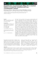
Table 1. Parent materials associated with particular soils in the St. John River
Valley, northern Maine, study areas. (Arno, 1964)
4
A derivative surficial geology map of the two study areas can be compiled by
designating colors or patterns to soil survey map units that represent soil series that
typically develop in a similar surficial geology unit. This compilation method does not
require computing technology and thus is available to those not having access to such
technology. However, computers were used for this project. A geographic information
system (GIS) (ARC/INFO, 1995) was used to manipulate the soil, surficial and attribute
data for the project. GIS has unique capabilities that can greatly enhance the
quantitative evaluation of this research. “The ability to generate maps via the overlay
process with data derived from various sources and at various scales is a highly
effective, rapid process” (Steinwand, 1992). Overlay analysis is a powerful technique in
utilizing the derivative surficial geology map to identify spatial distributions and
relationships in soil survey map units.
Within this framework, non-geologic influences that may account for
discrepancies in the distribution of surficial geology units among the data sets are
recognized. The non-geologic influences include the time involved in field data
collection, the intended purpose of the map, and map scale. The comparison process
undertaken by this research may or may not be affected by these influences (Lindholm,
1993, 1994; Kite, 1982).
5
PURPOSE
The purpose of this research is to investigate the utility of using soil survey maps
to represent the surficial geology of portions of the Lower St. John River Valley of
Northeastern Aroostook County, Maine (figure 1). This area was chosen because of the
availability of soil data and three different types of surficial geology data. Soil surveys
conducted in the early 1960's for agricultural purposes by the Soil Conservation Service
cover the entire American portion of the St. John River Valley in northeastern Aroostook
County (Arno, 1964). These soil surveys are the source of soil data for this project.
Surficial data were obtained from two published sources: United States Geologic Survey
Hydrologic Atlas (Prescott, 1973) and Maine Geological Survey Maps of the Surficial
Geology of Fort Kent, Stockholm, Van Buren, and Eagle Lake quadrangles (Genes,
undated; 1978A; 1978B; 1981). Unpublished records of surficial deposits obtained
through extensive field work conducted by J. Steven Kite from 1977 to 1989 in
Northeastern Aroostook County, Maine, collected for genetic-stratigraphic interpretation
provide a third source of surficial geology data for this project.
A map portraying the geographic distribution of the surficial geology of the areas
based solely on information derived from soil survey maps was compiled. Agreement
among the derivative map, Prescott's map, Genes’s maps, and Kite’s point data was
assessed. Kite's point records of surficial geology deposits were used to determine the
position for all comparisons.
6
7
RESEARCH OBJECTIVES
In order to fulfill the purpose set forth in this study, the following objectives have
been identified:
Primary objective
1. To employ the multi-layer analytical capabilities of a geographic information
system (GIS) to examine soil-surficial geology relationships in Northern Maine.
Secondary objectives
1. To compile a derivative surficial geology map of selected areas in the St. John
River Valley in Northeast Aroostook County, Maine, derived solely from soil survey data
as represented in the Soil Survey of that area (Arno, 1964).
2. To compare the derivative surficial geology map, Prescott's (1973) surficial
geology map, Genes's (undated; 1978A; 1978B; 1981) surficial geology maps, and the
geographic distribution of surficial geology deposits obtained through field observations
by J. Steven Kite (1977 to 1989).
3. To determine which of the three maps, the compiled surficial map, Prescott's
(1973) map or Genes's (undated; 1978A; 1978B; 1981) maps has the best fit to Kite's
unpublished point observations (1977 to 1989).
4. To determine which of the three surficial geology sources, Kite's unpublished
point observations (1977 to 1989), Prescott's (1973) map or Genes's (undated; 1978A;
1978B; 1981) maps has the best fit to the map derived from soils.
8
STUDY AREAS
The two study areas are located in Northeastern Aroostook County, along the St.
John River, on the northern border of Maine. The study areas include portions of the St.
John River Valley near Fort Kent and another section of the valley stretching from the
town of Grande Isle to the town of Hamlin. The two areas were delineated as the
research site because they are areas that contain all four of the data sources. The
surface area is approximately 210 km
2
and lies within the Fort Kent, Eagle Lake,
Stockholm and Van Buren 15 minute topographic quadrangles (figure 1). Data for this
project occurs on portions of seventeen soil survey sheets in Aroostook County, Maine
(Arno, 1964) (figure 2). All the data sets used in this research include observations within
the designated areas.
The study areas have rich glacial histories reflected by the surficial geology in
which soils formed. Till is the dominant parent material and is mostly derived from local
sedimentary rock. Glacial meltwaters deposited sandy and gravelly outwash along the
St. John River. Silty and sandy stream terraces formed from alluvial material deposited
in areas that were floodplains of the river when it carried much more water. Most of the
alluvium has been in place long enough to have formed a B horizon. Small islands
formed of recent alluvium occur in the river and consist mainly of very fine sand and silt
(Arno, 1964).
Soil formation is also a reflection of the length of time the soil has been
developing (Arno, 1964). Soil age is indicated by horizon development. The oldest soils
in the area have developed in till or outwash. These soils have developed since the Late
Wisconsin glaciation, and have strong A, B and C horizons. Soils on stream terraces
have weakly developed horizons. Soils in recently deposited alluvium have very little or
no horizon development.
The topography along the St. John River consists of narrow floodplains (Arno,
1964). Few of these floodplains extend beyond one half mile in width. The moderately
9
sloping ridges in the area are 800 to 1400 feet above sea level with the steepest slopes
extending in a northerly direction toward the St. John River.
The area has a cool, humid continental climate (Arno, 1964). The ground is
frozen between November and April denoting a long cold winter. Precipitation averages
34 inches per year, with much of it falling as snow.
10
11
PREVIOUS RESEARCH
Part of the literature relevant to this study concerns the areas’ geographic
location in relation to late Wisconsin history. This area has received much attention
concerning the deglaciation pattern of the Laurentide Ice Sheet (Lowell, et al., 1990).
Theories exist regarding the expected distribution of glaciofluvial deposits that may be
confirmed or refuted, in part, by the additional evidence obtained by this research as to
where these deposits are in relation to a postulated ice cap divide extending over the
area (Fastook, et al., 1980; Hughes, et al., 1985). Support for this glacial history has
been demonstrated by studies conducted on erosional features, such as rat tail
striations, and other directional features in the area (Lowell, 1980; Nicholas, et al., 1981;
Kite, et al., 1981; Nicholas and Kite, 1981). Genes et al. (1980), in investigating the
surficial geology of Aroostook County, Maine, concluded that granite-gneiss erratics of
Canadian Shield provenance in the Van Buren till indicated advance of the Laurentide
Ice Sheet into northern Maine during late Wisconsin time.
Understanding the soil-surficial geology relationship examined in this study is
predicated on an understanding of soil genesis. Soil genesis includes the weathering of
both surficial mantle rock and alterations of organic compounds (Buol et al., 1980). In
northern Maine, glacial till, the dominant parent material, tends to reflect the lithology
and composition of the material over which the glaciers moved. Soil is a function of
climate, parent material, relief, biota and time (Jenny, 1941). Arno contends the
development of soils depends on five factors: the parent material; the climate; the
biological forces; the relief or lay of the land; and time (1964). The kind of soil that
develops depends on the interaction of these five factors. Since parent material is one of
these factors, soil survey maps may be potential sources of data for representations of
surficial geology in northern Maine (Kite, 1982). After establishing the soil-surficial
12
geology relationship, it is possible to infer soil types from where they reside in the
landscape.
Lindholm (1993; 1994) used soil survey maps to compile a geologic map of the
Culpeper basin in Virginia showing bedrock distribution. Compared to two published
geologic maps of the area, the compiled map proved to be quite accurate. Kite (1982)
used soil survey maps to compile a map of glaciofluvial deposits in northern Maine. He
determined soil maps are somewhat successful in showing the distribution of lacustrine
silts and clays. Using soil surveys as potential sources of geologic information might
prove to be relatively accurate, readily available and cost efficient to a geologist for use
in field data collection as a primary tool when surficial geology is not available (Lindholm,
1994).
Less time is involved in the production of a geologic map compiled from soil
survey sheets versus one compiled employing conventional mapping techniques.
Conventional mapping techniques involve extensive research and observation in the
field. Conventional soil mapping data for soil surveys include: steepness, length and
shape of slope, stream size and speed, kinds of vegetation, types of rock, bore hole
data, comparisons to local and regional soil profiles, and comparisons to aerial
photographs (Arno, 1964). Data generated for surficial mapping include: location type,
coordinate system, landform, elevation, photos, sediment composition of geologic units,
age, depositional environment of the unit, sample analysis including thickness, texture,
color, HCl reaction, unit sorting, bed sorting, strength, roundness and sphericity,
sedimentary structures, secondary feature development subsequent to original
deposition, underlying contact units, and directional data (Kite, et al., 1986; Kite, 1994).
Since soil surveys contain descriptions of each soil type and the parent material in which
it formed, using these surveys as a source for geologic information involves merely
identifying the soil type formed in a particular parent material.
13
The area surveyed in relationship to the amount of time involved in conventional
mapping indicates a degree of intensity (Kite, 1982). Prescott (1973) in compiling his
Groundwater Favorability and Surficial Geology of the St. John River Valley, Maine
surveyed at a pace of approximately 16 km
2
to 24 km
2
per day (assuming a five-day
work-week) with perhaps a reduction in this intensity of 8 km
2
to 12 km
2
per day due to
mulit-seasonal work (Kite, 1982). Genes (undated; 1978A; 1978B; 1981) covered 20 km
2
to 28 km
2
per day (assuming a five-day work-week) during his mapping (Kite, 1982). The
soil scientists of Northeastern Aroostook County Maine mapped at a rate of 1 km
2
to 2
km
2
per day (assuming a five-day work-week) in the production of the soil survey of that
region (1964). The measurement of the intensity of data collection employing the same
or similar field mapping techniques may reflect this precision in units mapped. The
amount of field observation has a direct cost correlation: as field work increases, costs
increase.
The compilation of surficial and other types of maps using soil survey data as the
primary source of input involves much less time to produce, reflecting a decrease in field
work. A geology map of the Culpeper Basin, Virginia, an area comprising 2,200 km
2
, was
completed in two months mapping 36 km
2
per day using soil survey data (Lindholm,
1994). This is a much faster rate of mapping than conventional geologic mapping
affords. Lindholm enjoyed this rate of mapping because of the availability of soil survey
maps of the area. In turn, cost efficiency increased along with this increased rate of
mapping speed.
14
RESEARCH METHOD
Soil Survey Data
The study areas contain smoothly sloping soils in till derived from shale and
limestone, smoothly sloping soils in till derived from acid rock, irregularly sloping shallow
to moderately deep soils in till derived from calcareous rocks, irregularly sloping soils in
till derived from acid rock, nearly level to sloping soils of the flood plains and terraces,
and nearly level to gently sloping poorly drained and very poorly drained soils in firm till.
The landscape is comprised of geomorphic features that include floodplains, bedrock
outcrop, terraces, eskers, deltas, kames, kame terraces, and hummocky, blanket and
veneer surfaces. A total of 73 different mapping units were identified by the Soil
Conservation Service (Arno, 1964) (table 2) in the two study areas. These units
represent 28 soil series (table 3). Appendix 1 describes the soil series.
The 73 mapping units are located on portions of 17 Soil Survey of Aroostook
County, Maine, Northeastern Part (Arno, 1964) map sheets at a scale of 1:20,000. Aerial
photographs comprise the base maps for the soil data. Each paper map sheet covers
approximately 38.7 km
2
. The two study areas lie within 47
°20’00’’ and 47
°00’00’’ N
latitude, and 68
°40’00’’ and 67
°45’00’’ W longitude. The soil data were collected on the
basis of soil type, location and possible use (Arno, 1964). The primary focus of the
collection was slanted toward agricultural use.
The soil survey sheets were converted to digital format using ARC/INFO
Geographic Information System, Version 6.0 (ESRI, Inc., 1995). ARC/INFO establishes
spatially referenced data into covers that contain information about spatial relationships
and information about points and areas. The conversion process involved hand-digitizing
the soil boundaries from the detailed soil maps created by soil scientists. Universal
Transverse Mercator (UTM) geographic reference system was used for common
referencing. The geo referencing was established by locating point values on UTM
topographic sheets of road intersections or sharp turns, and in some extreme
15
Table 2
MAP SYMBOL
SOIL SERIES
SLOPE
(Percent)
AgA Allagash 0 to 2
AgB Allagash 2 to 8
AgC Allagash 8 to 15
AgD Allagash 15 to 35
CdB Canadaigua silt loam, thin solum 0 to 8
CgA Caribou 0 to 2
CgB Caribou 2 to 8
CgC Caribou 8 to 15
CgC2 Caribou 8 to 15 eroded
CgD Caribou 15 to 25
CgD2 Caribou 15 to 25 eroded
CgE Caribou 25 to 45
CoA Conant silt loam 0 to 2
CoB Conant silt loam 2 to 8
CoC Conant silt loam 8 to 15
DaB Daigle silt loam 2 to 8
EaA Easton and Washburn silt loams 0 to 8
EaB Easton and Washburn slit loams 2 to 8
EsB Easton and Washburn stony silt loams 0 to 8
FhA Fredon and Halsey silt loams 0 to 2
FhB Fredon and Halsey silt loams 2 to 8
HaA Hadley silt loam level
HaB Hadley silt loam undulating
HoA Howland gravelly loam 0 to 2
HoB Howland gravelly loam 2 to 8
HoC Howland gravelly loam 8 to 15
HvB Howland very stony loam 0 to 8
HvC Howland very stony loam 8 to 15
MaA Machias gravelly loam 0 to 2
MaB Machias gravelly loam 2 to 8
MaC Machias gravelly loam 8 to 15
MbA Madawaska fine sandy loam 0 to 2
MbB Madawaska fine sandy loam 2 to 8
MbC Madawaska fine sandy loam 8 to 15
Md Made land
MhB Mapleton shaly silt loam 0 to 8
MhC Mapleton shaly silt loam 8 to 15
MhD Mapleton shaly silt loam 15 to 35
Mn Mixed alluvial land
MoA Monarda and Burnham silt loams 0 to 2
MoB Monarda and Burnham silt loams 2 to 8
MrB Monarda and Burnham very stony silt loams 0 to 8
Table 2. The 73 soil mapping units in the northern Maine study areas and associated
slope (Arno, 1964).
16
Table 2
MAP SYMBOL
SOIL SERIES
SLOPE
(Percent)
NcA Nicholville silt loam 0 to 2
NcB Nicholville silt loam 2 to 8
Pa Peat and Muck
PgA Plaisted gravelly loam 0 to 2
PgB Plaisted gravelly loam 2 to 8
PgC Plaisted gravelly loam 8 to 15
PgD Plaisted gravelly loam 15 to 25
PgE Plaisted gravelly loam 25 to 45
PrB Plaisted very stony loam 0 to 8
PvB Plaisted and Howland very stony loams 0 to 8
PvC Plaisted and Howland very stony loams 8 to 15
RaA Red Hook and Atherton silt loams 0 to 2
RaB Red Hook and Atherton silt loams 2 to 8
SaA Salmon silt loams 0 to 2
SaB Salmon silt loams 2 to 8
SaC Salmon silt loams 8 to 15
Sb Steep rockland and Thorndike materials
SgA Stetson gravelly loam 0 to 2
SgB Stetson gravelly loam 2 to 8
SgC Stetson gravelly loam 8 to 15
SgD Stetson gravelly loam 15 to 25
SgE Stetson gravelly loam 25 to 45
ThB Thorndike shaly silt loam 0 to 8
ThC Thorndike shaly silt loam 8 to 15
ThD Thorndike shaly silt loam 15 to 25
ThE Thorndike shaly silt loam 25 to 45
TkB Thorndike very rocky silt loam 0 to 8
TkC Thorndike very rocky silt loam 8 to 15
TkD Thorndike very rocky silt loam 15 to 25
TkE Thorndike very rocky silt loam 25 to 45
Wn Winooski silt loam
Table 2. The 73 soil mapping units in the northern Maine study areas and associated
slope (Arno, 1964).
17
Table 3
PARENT MATERIAL
Well drained
soils
Moderately well
drained to
somewhat
poorly drained
soils
Poorly drained
soils
Very poorly
drained soils
Glacial till derived from
acid shale and slate
Plaisted
gravelly till
Howland
gravelly till
Monarda
gravelly till
Burnham
gravelly till
Glacial till derived from
limy shale
Caribou
gravelly till
Conant
firm till
Easton
firm till
Washburn
firm till
Glacial till derived from
weakly calcareous or acid
shale or slate
Daigle
firm till
Glacial till derived from
acid or weakly calcareous
shale
Thorndike &
Steep
Rockland
thin till
Glacial till derived from
calcareous rock
Mapleton
thin till
Glacial outwash and
gravelly material on
terraces
Stetson
gravelly
Machias
gravelly
Fredon
Halsey
Silty material on terraces
Salmon Nicholville Canadaigua
Sandy material on
terraces
Allagash
Madawaska Red Hook Atherton
Silty and fine sandy
floodplain deposits
Hadley Winooski
Mixed
Alluvial Land
gravelly
Mixture of soil materials –
Made Land
Decaying organic
materials
Peat & Muck
Table 3. Soil series in the northern Maine study areas arranged according to drainage catenas.
(Made Land, Mixed Alluvial Land, Peat & Muck, and Steep Rockland are not classified
as soil series.) (Arno, 1964)
18
cases stream forks, and locating these on the soils base of the aerial photographs to use
as tic points as the soils map sheets contained no spatial referencing.
Once digitized, the covers were appended into the final coverage representing
the study areas (figure 3). This vector format was edited interactively to add polygon
labels that identify the soil units, to repair open and closed polygons, and to connect like
soil polygons to adjacent units. The purpose of this outline map of the digitized soil
sheets is not for analysis or intrepretation, but merely as a depiction. Any map of the
soils data at the scale this format allows would be impossible to represent in a
meaningful way. A legend of the 73 soils on the depiction would be too extensive to
include.
The described conversion process introduces various sources of positional error
from the original maps or from digitization or from registration that may impact the overall
accuracy of the database and the end product. The source soil documents used in the
conversion may be distorted resulting in map boundary adjustments. This distortion may
be due to paper shrinkage or expansion. Because the original soils maps are no longer
available, distortion may also result from photocopying these maps for digitizing. The
original drafting may also be flawed (Maling, 1989). Aerial photographs taken in 1942,
1947, and 1960 and used in the construction of the soil base maps in 1962 may no
longer be accurate. The soil boundaries were drawn by the Soil Conservation Service on
these photographs because they show woodlands, buildings, field borders, trees, roads,
streams, and other detail to enhance positional accuracy. They were not spatially
referenced when produced in 1962. Problems arise when attempting to locate
positionally accurate points by the use of these physical and cultural features for a
digitizing reference grid. In referencing points from 7.5 minute topographic quadrangles
(Fort Kent North, Fort Kent South, Wheelock, Paulette Brook, Violette Stream, Van
Buren, Doyle Ridge, and Hamlin) produced from aerial photographs taken in 1982 and
edited in 1985 and 1986 for location on the soil sheets, it was discovered that some
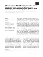
Figure 3. Depiction of the surficial geology
units derived from soil survey maps in the
northern Maine study areas (Arno, 1964).
19