báo cáo khảo sát địa chất
Bạn đang xem bản rút gọn của tài liệu. Xem và tải ngay bản đầy đủ của tài liệu tại đây (451.32 KB, 14 trang )
PROJECT : LOOKING FOR A QUARRY SITE AVALILABLE PRODUCING SUITABLE ROCK
MATERIALS USED FOR VPR BAI GOC SEASPORTLFOR A QUARRY SITE SEAPORT PROJECT.
Report on soil investigation
CONTENT
1
Introduction ............................................................................................................ 3
1.1
General ............................................................................................................ 3
1.2
Legal basic ...................................................................................................... 4
1.3
Scope of work................................................................................................. 4
1.4
Location of survey area ................................................................................... 5
1.5
Study scope and Standard system application .................................................. 5
2
Quantity of geotechnical investigation .................................................................... 6
3
Equipments ............................................................................................................. 6
4
Survey method ........................................................................................................ 7
4.1
Exploration Drilling process and Sampling ...................................................... 7
5
Laboratory Test ...................................................................................................... 7
6
Daily report and Photographs.................................................................................. 8
7
8
6.1
Daily report ..................................................................................................... 8
6.2
Photographs ..................................................................................................... 8
Geotechnical characteristics of the project area ....................................................... 8
7.1
Geological feature of area ................................................................................ 8
7.2
Tectonics and Earthquake. ............................................................................. 11
7.3
Hydrogeological condition............................................................................. 11
7.4
Strata main of the investigation area .............................................................. 12
Conclusions and recommendations ....................................................................... 13
8.1
Conclusions ................................................................................................... 13
8.2
Recommendations ......................................................................................... 14
PORT TECHNOLOGY CONSTRUCTION CONSULTING AND COMMERICAL ( JSC)
Page 1
PROJECT : LOOKING FOR A QUARRY SITE AVALILABLE PRODUCING SUITABLE ROCK
MATERIALS USED FOR VPR BAI GOC SEASPORTLFOR A QUARRY SITE SEAPORT PROJECT.
Report on soil investigation
Appendices
Location of boreholes
Appendix No1
Boring logs
Appendix No2
Sumary of laboratory result
Appendix No3
Geologycal profiles
Appendix No4
Daily report and Photographs
Appendix No5
Local Geological map
Appendix No6
PORT TECHNOLOGY CONSTRUCTION CONSULTING AND COMMERICAL ( JSC)
Page 2
PROJECT : LOOKING FOR A QUARRY SITE AVALILABLE PRODUCING SUITABLE ROCK
MATERIALS USED FOR VPR BAI GOC SEASPORTLFOR A QUARRY SITE SEAPORT PROJECT.
Report on soil investigation
1 Introduction
1.1 General
- Looking for a quarry site available producing suitable rock materials used for
VPR Bai Goc seaport Project at Dong Hoa District – Phu yen province, survey
construction will provided to proved rock for the project area as preliminary estimate
quatity and volume of rock. Engineering geologycal investigation consists of drilling,
sampling, laboratory testing.
- The contract has sighed 25/07/2014 by Technology construction consulting and
commercial with Vung ro petroleum liability limited co.
- The geological survey work in situ has started September, 30th 2014 and
completely October, 15th 2004.
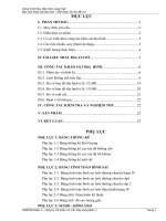
Map of locaiton survey of the project area
PORT TECHNOLOGY CONSTRUCTION CONSULTING AND COMMERICAL ( JSC)
Page 3
PROJECT : LOOKING FOR A QUARRY SITE AVALILABLE PRODUCING SUITABLE ROCK
MATERIALS USED FOR VPR BAI GOC SEASPORTLFOR A QUARRY SITE SEAPORT PROJECT.
Report on soil investigation
1.2 Legal basic
Construction Law No. 16/2003 QH11 by Social Republic of Viet Nam’s national.
Assembly at the 4th meeting on construction, tenure XI on 26th November 2013.
Decree No. 209/2004/NĐ – CP by Government dated 16th December 2004,
stipulating the management of construction quality.
Decree No. 12/2009/ NĐ – CP dated February 10, 2009 by Government.
Decree No. 12/2006/CT – BXD dated November 11, 2006 by Government.
Circular No. 12/2005/TT – BXD dated July 15, 2005 by Ministry of
Construction. Instruction for some contents of construction project management and
ability terms of individuals and organizations of construction activity.
Circular No. 49/2008/NĐ – CP dated April 18, 2008 for modification,
supplementary of Decree number, 209/2004/NĐ – CP dated September 16, 2004
stipulating the management of construction quality.
Survey Task and Survey Execution Plan Which were approved by PORT
TECHNOLOGY CONSTRUCTION CONSULTING AND COMMERICAL (JSC).
The geotechnical investigation for the project was carried out based on the
following document:
Economic contract on soil investigation for Looking for a quarry site available
producing suitable rock materials used for VPR Bai Goc seaport project.
1.3 Scope of work
The geological survey work aims to supply information about geotechnical condition
of the mining material area, defines boundary of layer, Soil sampling and Rock sampling
in order to determine physical – mechanical. The depth of borings and the type of
samples to be taken at each hole will be as directed by the Client.
The finish depths of the borings are shown in the table quantily (table 2). The actual
depth of each borehole will depending on actual thickness and conditions weathered
rock.
Based on the soil classification, assess geotechnical and estimated the actual volume,
quality of rock material.
PORT TECHNOLOGY CONSTRUCTION CONSULTING AND COMMERICAL ( JSC)
Page 4
PROJECT : LOOKING FOR A QUARRY SITE AVALILABLE PRODUCING SUITABLE ROCK
MATERIALS USED FOR VPR BAI GOC SEASPORTLFOR A QUARRY SITE SEAPORT PROJECT.
Report on soil investigation
1.4 Location of survey area
Location of bore hole in the plan area is at Bai Nga – Dong Hoa District – Phu Yen
Province. Based on determine coordinates of boreholes, positions are determined by
GPS tool and about elevation had provided by Client.
1.5 Study scope and Standard system application
Technical specification of the project area follows as:
A.
American Standards ASTM
No
Tests
American Standards ASTM
1
Drilling
1.1
Auger Borings
ASTM D 1452-80
1.2
Field Logging
ASTM D 5434-03
1.3
Classification of Soils for engineering ASTM D 2487-06
Purposes
1.4
Descriptionand Identification of Soils
ASTM D2488-06
1.5
Core drilling
ASTM D 2113-83
ASTM D 2113-06
2
Sampling
2.1
Guide for sampling
ASTM D 420
2.3
Field Logging
ASTM D 5434-03
2.5
Soils - Sampling, packing
ASTM D 4820
2.6
transportation and curing of samples
3
Rock
3.1
Standard Test Method for Unconfined
Compressive Strength of Intact Rock Core
Specimens
B.
ASTM D 2938-95
Other Reference standards:
Method statement for Geotechnical Investigation was approved by Engineer of
Employer.
ASTM – American Society for testing and Material.
PORT TECHNOLOGY CONSTRUCTION CONSULTING AND COMMERICAL ( JSC)
Page 5
PROJECT : LOOKING FOR A QUARRY SITE AVALILABLE PRODUCING SUITABLE ROCK
MATERIALS USED FOR VPR BAI GOC SEASPORTLFOR A QUARRY SITE SEAPORT PROJECT.
Report on soil investigation
BS – 5930: 1999 Code of Practice for site investigation British Standards
instution.
TCVN – Vietnam Construction Standard (22TCN 259 – 2000).
Soil names was determined by site boring record of the boreholes. Soil layers were
determined based on classification in situ, state and distribution of them.
2
Quantity of geotechnical investigation
Site investigations were include drilling, taking sample:
Drilling and taking samples at 2 Borehole;
42 taken samples in situ and 10 taken samples were tested in laboratory;
More details on quantity of works are shown on table 2
QUANTITY OF WORKS INVAGETIGATION
No Borehole
Actual coordinates
X
1
2
BH01
BH02
3
Y
1428479.00 602339.00
1428363.00 602270.00
TOTAL
Elevation Depth of
(m)
Borehole
+52.50
+117.00
41.00
55.00
96.00
Sampling
Rock
sample
16
17
33
Number
of core
Disturbed
box
sample
4
8
5
11
9
19
Equipments
Using 01 drilling machines XY – 1A Made in China with maximum capacity of
150m. Following equipments were used for site investigation:
Table No.3: Equipments were used for the site investigation
No.
2
Equip. Name
Rotary coring
type
Hydraulic pump
3
Positioning
4
5
6
7
Leveling
SPT
Double tube
Drilling rod
1
Model/Manufacturer
Capacity
Unit
Quantity
XY-1A, XJ100/China
150m
No.
02
China
Total Station/England
DGPS/France
Pentax/Japan
Vietnam
Vietnam
China
-
No.
-
No.
-
No.
No.
Set
Meter
02
01
01
01
02
02
140
PORT TECHNOLOGY CONSTRUCTION CONSULTING AND COMMERICAL ( JSC)
Page 6
PROJECT : LOOKING FOR A QUARRY SITE AVALILABLE PRODUCING SUITABLE ROCK
MATERIALS USED FOR VPR BAI GOC SEASPORTLFOR A QUARRY SITE SEAPORT PROJECT.
Report on soil investigation
8
9
Casing
Other appliance
China
-
-
Meter
-
60
-
Manpower attended in the investigation is shown in the table below.
Table No.4: Manpower
No.
1
Job & Degree
Qualified geotechnical
engineer
2
4
Geotechnical engineer
3
Worker
4
5
Operator
Surveyor
6
7
Lab staff
Geotechnical engineer
Responsibility
Manager & officer in
charge
Field manager and
recording
Drilling
Number Remarks
01
QC
Operate drilling
Positioning and
leveling
Lab testing
Making report
01
-
05
-
011
1
-
05
02
-
Survey method
4.1 Exploration Drilling process and Sampling
Drilling methods shall be rotary, core rotary or percussion drilling with betonies
solution
The core samples are taken 100% by double core tube according to ASTM D
2113-06. The equipment ensures the core samples with proper condition during
investigation. The rock sample are taken by diamond drill bit, shall allow the assessment
of total core recovery (TCR), solid core recovery (SCR), and fracture index and rock
quality designation (RQD).
5
Laboratory Test
Physical – mechanical properties of rock (specific gravity, Determination of
amorphous silicate content, water absorption test, Determination of alkali silica
reactivity and Unconfined compression test of rock.) are determined in accordance with
Vietnamese standard and American standard ASTM D854, C3111-2007, D 2938-95,C
127, C 227.
PORT TECHNOLOGY CONSTRUCTION CONSULTING AND COMMERICAL ( JSC)
Page 7
PROJECT : LOOKING FOR A QUARRY SITE AVALILABLE PRODUCING SUITABLE ROCK
MATERIALS USED FOR VPR BAI GOC SEASPORTLFOR A QUARRY SITE SEAPORT PROJECT.
Report on soil investigation
6
Daily report and Photographs
6.1 Daily report
A daily quantity Report shall be completed by Geotechnical engineer and agreed to
by the Client upon completion of each day’s work. by Geotechnical engineer will come
to agreement with the Client or his representative on quantities of work performed each
day. Daily report shall be supplied for the Client sighed by Geotechnical engineer and
the Client upon the completion of each day’s work.
6.2 Photographs
All the field investigation such as boring, sampling have taken photographs. More
details in photograph can be see in appendix No 5 (inserted in the daily reports).
7
Geotechnical characteristics of the project area
7.1 Geological feature of area
Based in geology map sheet of Tuy Hoa 1:200 (D-49-XXVI) on 1:200.000 scale,
which was issued by the Geological Bureau, geological structure in the geological
investigation area are divided as follows:
Bedrock
Complex Deo Ca (yD-yl;-yK de): The Complex Deo Ca is exposed in Tra Buc,
Muong Han, Song Cai, Nui Huang and Deo Ca massifs. It is composed of 3 intrusive
phases and 1 dyke phase.
- Phase 1 (Kđc1): exposed in the northern margin of the Deo Ca massif in some
small bodies. It is composed of biotite-hornblende granodiorite and biotite-hornblende
granomonzonite. These rocks are grey coloured with pink spots, irregularly smallgrained, of massive structure and hemidiomorphic texture. Mineral composition (%):
plagioclase = 28-47; quartz = 17-28; kalifeldspath = 18-40; biotite = 5- 15; hornblende =
0-8; together with sphene, apatite, zircon and magnetite.
- Phase 2 ( đc2): is the main component of the Complex Deo Ca. It is
composed of biotite granosyenite and biotite (hornblende) granite. These rocks are pinkgrey coloured, coarse-grained, of massive structure and hemidiomorphic texture, but
PORT TECHNOLOGY CONSTRUCTION CONSULTING AND COMMERICAL ( JSC)
Page 8
PROJECT : LOOKING FOR A QUARRY SITE AVALILABLE PRODUCING SUITABLE ROCK
MATERIALS USED FOR VPR BAI GOC SEASPORTLFOR A QUARRY SITE SEAPORT PROJECT.
Report on soil investigation
widespread porphyritic texture, with pink kalifeldspath as phenocrysts, 0.5 - 2.5cm in
size, on a medium-grained groundmass. Mineral composition (%): plagioclase = 14-32;
quartz = 18-34; kalifeldspath = 30-62; biotite = 3-10; hornblende = 0-5 together with
sphene, apatite, zircon and magnetite.
- Phase 3 (đc3): exposed in the Deo Ca massif in some small bodies. It is
composed of biotite granite and biotite granosyenite. These rocks are pink coloured,
irregularly small-grained, of massive structure and hemidiomorphic texture. Mineral
composition (%): plagioclase = 22-33; quartz = 25-38; kalifeldspath = 33-39; biotite = 36 together with sphene, apatite and tourmaline.
- Dyke phase: found in almost all massifs of the complex. The dykes are usually
some decimetres to some metres thick, stretching on tens metres. They are composed of
aplitic granite, pegmatoids and small- grained porphyritic granosyenite. Accessory
mineral association in hard rock concentrates panning samples (g/t): magnetite =
1,014.9; ilmenite = 13.33; hematite = a little, pyrite = 2.96, sphene = 87.81; apatite 0.49;
zircon = 7.09; cyrtolite = 0.7 together with molybdenite, anatase, fluorite, rutile and
tourmaline. Petrochemically, the described rocks belong to the calc-alkaline line rou
alkaline t e with otassiumoften prevailing over sodium (Na / K = 0.51 - 0.87). According
to the classification of Chappell and White (1974), they belong to the I-granite typc, or
after Ishihara S. (1977), to the magnetite granite series. Significant microelements
(clarke): Sr = 0.66 - 1; Ba = 0.38 - 0.56 having high frequency (82-100%); Co = 3.5; Ni
= 1.5 - 5.6; Cu = 2.58; Pb = 2.4; Ag = 200; Sn = 3.77; Mo = 8; Yb = 2.78 and Zn = 1.66
- 4.16. Related minerals: Cu-Mo (Deo Cll massif). Granosyenite of the Deo ca Complex
penetrates granodiorite of the Upper Jurassic Dinh Quan Complex, observed at Hoa
Nguyen, felsic cffusives of the Cretaceous Nha Trang Formation, observed at Niii
Huong, as well as Lower Jurassic Dray Linh Formation in the northern foot of the Deo
Cll massif. Isotopic datation (K-Ar) of biotite from granite collected in the northern foot
of the Deo Cll massif gives a value of 127 Ma (Nguyen Xu an Bao and Huynh Trung,
1980), and from granite of the Deo Cll massif gives 87 ± 3.3 Ma (Lasser, 1974). All
above-cited factual data allow to date the complex as Cretaceous.
Quaternary deposite
PORT TECHNOLOGY CONSTRUCTION CONSULTING AND COMMERICAL ( JSC)
Page 9
PROJECT : LOOKING FOR A QUARRY SITE AVALILABLE PRODUCING SUITABLE ROCK
MATERIALS USED FOR VPR BAI GOC SEASPORTLFOR A QUARRY SITE SEAPORT PROJECT.
Report on soil investigation
Lower Pleistocene, upper part: Tuy Hoa Formation (amQ/ th).The Tuy Hoa
Formation was described recently by Tran Tinh and VG Van Vinh (1993) while
surveying the Tuy Hoa map sheet on 1:200000 scale, grouping fluvio-marine sediments
lying in the depth from 76.8 to 106.5m (borehole TH.2 at Dong Tac village, Tuy Hoa
District) beneath the Tuy Hoa plain. The section IS composed of 4 members:
- Member 1 (106.5 - 102.2m): cobble, pebble, granule grading upward to sandf grit
and clay with interbeds of clayish silt; 4.3m thi~k. Grain composition of pebble and
granule consists of siltstone, rhyolite, arkosic sandstone and quartz. Granulity
composition (%): pebble-grit (1- 5mm in size) = 13-20; coarse sand = 30-40; mediumgrained to fine sand = 30-40; clay-silt = 10-15; cobble <1. The grains are badly rounded
and sorted. The granulity quickly changes upward. In the upper part of the member the
granulity is seen as follows (%): grit = 4.5 - 35; sand = 30-60; silt = 9-35; and clay = 2035. The panning sampling from drill core has been giving sapphire (1 to 5 grains, 0.12 x
0.25mm), gold (3-5 grains), cassiterite, cinnabar, ilmenite, monazite, tourmaline,
limonite, zircon and rutile.
- Member 2 (102.2 - 90m): greenish-grey to black-grey silt and clay intercalated
with white-grey fine sand; 12.2m thick. Silicate analysis of clay gives (%): Si02 = 59.02;
Al203 = 17.26; Fe203 = 6.07; S03 = 0.77; P20S = 0.03; Na20 = 1.25; K20 = 2.93; H20
= 2.52 and; LOI = 8.16.
- Member 3 (90-81m): black-grey clay and coaly clay bearing carbonized plant
debris and large-sized mollusc shells; 9m thick. Foraminiferas studied by Pham Thi
Bach Mai comprise Nonion grateloupi, Rotalia japonica, R. tochigensis, R. ozawai,
Elphidium
craticulatum,
E.
jenseni,
Giroidina
nipponica,
Bolivina
striatula
nishikanbaraensis, Bucella frigida, Quinqueloculina seminula etc. giving the age from
Mio-Pliocene to present day, and the littoral environment.
- Member 4 (81-77m): greenish-grey clay, 4m thick.
The total thickness of the formation in this section reaches 29.5m. The Tuy Hoa
Formation has been assigned to Early Plei~tocene, upper part
According to the map 1/50.000 Tuy Hoa formation is devides into parts, The Area
A belong to follow complex:
PORT TECHNOLOGY CONSTRUCTION CONSULTING AND COMMERICAL ( JSC)
Page 10
PROJECT : LOOKING FOR A QUARRY SITE AVALILABLE PRODUCING SUITABLE ROCK
MATERIALS USED FOR VPR BAI GOC SEASPORTLFOR A QUARRY SITE SEAPORT PROJECT.
Report on soil investigation
- Wind deposite VQIV23 includes dunes located on the south and east
- Marine – Swamp Depsite Hon Chong mbQIVhc 2-3
7.2 Tectonics and Earthquake.
Faults
Faults are fairly developed in the Phu Yen Province, having mainly 3 principal
trends: NE-SW, NW-SE and N-S. NE-SW faults are developed with medium scale in the
Deo Phuong Hoang - Deo Ca block, with the Vinh Long - Tuy Hoa fault as the most
significant. All the faults of this group have an almost vertical slip surface and a clear
left-lateral movement.
- N-S faults are small- and medium-sized faults, developed in Hoa Nguyen area.
They all have a vertical slip surface.
- NW-SE faults have been recognized in Deo Ca and San Hoa areas, consisting of
small- to medium-sized faults.
According to the Geological Map 1/50.000, fault has not been discovered on the
investigation site.
Earthquake
According to the study and published by Global Physical Institute of Vietnam, the
area belong to stability area with intensity I= 7 (MSK scale) of earthquake ( TCXDVN
375-2006) with max magnitude a=0.0656 ,
7.3 Hydrogeological condition
The location is surrounded by Da Nong river and sea at the east. Ground water are
existing in made ground, zone of fissured and weathered and supplied mainly by rainy.
In according to the hydrogeological report of Phu Yen coastal sand established by
the Department of Water Resource Management, reserves of water in marine deposits is
medium and small only.
PORT TECHNOLOGY CONSTRUCTION CONSULTING AND COMMERICAL ( JSC)
Page 11
PROJECT : LOOKING FOR A QUARRY SITE AVALILABLE PRODUCING SUITABLE ROCK
MATERIALS USED FOR VPR BAI GOC SEASPORTLFOR A QUARRY SITE SEAPORT PROJECT.
Report on soil investigation
7.4 Strata main of the investigation area
Based on results of the site investigations & laboratory tests carried out by PORT
TECHNOLOGY CONSTRUCTION CONSULTING AND COMMERICAL JSC in
September and October 2014, 01 geotechnical profiles was made for illustration
stratigraphical structure of the project area.
More details on geotechnical profiles is shown in Appendix No3
Stratum of the investigation area can be divided into layers from top to bottom
described in details as follows:
1. Layer No.1(I): Stiff to very stiff,brownish grey, reddish brown, sandy clay with
grave
This soil layer distributes in all boreholes, the thickness of layer has changed range
from 3.64m (BH01) to 3.16m (BH02), the average thickness’one is about 3.4m with the
main composition are brownish grey, reddish grey, sandy clay.
2. Layer No2 (II): Zone of fissure and weathered rock. Composition main as
sandy clay, gravel, boulder.
This layer distributes in all boreholes. The elevation of surface layer has changed
range from +113.84m(BH02) to +48.86m(BH01) and the elevation of bottom layer has
changed from +89.20 (BH11) to +41.50 m(BH13), the average thickness of layer is
about 16.0m. The main composition of layer is Sandy clay mixed gravel, boulder.
3. Layer No3(III): Zone of Highly to completed weathered granite rock: brownish
grey, brown mixed gravel.
This layer is encountered in all boreholes, the thickness of layer is about 6.5m. The
main composition of layer is highly
to completed weathered granite rock, reddish
brown, brownish grey, brown mixed gravel, in the zone materials has changed into soil,
texture and structure intact had changed. Small fragments formed when crush in hand or
immerse in water.
4. Layer No4(IVa): Slightly to fresh granite rock: hard, little fissured, whitish
grey, pinkish gre, black spot, massive structure, granular texture, TCR >95%,
RQD>95%.
PORT TECHNOLOGY CONSTRUCTION CONSULTING AND COMMERICAL ( JSC)
Page 12
PROJECT : LOOKING FOR A QUARRY SITE AVALILABLE PRODUCING SUITABLE ROCK
MATERIALS USED FOR VPR BAI GOC SEASPORTLFOR A QUARRY SITE SEAPORT PROJECT.
Report on soil investigation
Layer No4 is defined as slightly to fresh granite rock. In this one, the color of rock
didn’t changed rock of materials (ogiginal color increases) whole texture and structure
same intack rock, hard deposit. The elevation of surface layer is encounterd in borehole
from +34.10m(BH01) to +84.90m(BH02). However boreholes finished we was undefine
bottom of layer at BH02.
Table: Total results of laboratory test.
No
No
BH
1
2
3
BH01
4
No
Sample
Depth
Specifi
c
gravity
Determination
of amorphous
silicate
content
(mmol/l)
Determination
Water
of alkali silica
absorption
reactivity
test (%)
(mmol/l)
Compression test
(Kg/cm2 )
dry
saturated
conditon
1211.78
1174.07
R11
23.05-23.35
R13
26.00-26.30
2.71
23.21
0.07
72.50
1311.34
1233.64
R16
32.00-32.25
2.70
11.55
0.33
165.00
1286.45
1195.94
R18
37.40-37.65
2.71
21.16
0.04
84.20
1304.49
1271.64
5
R14
35.00-35.25
1286.49
1217.66
6
R16
39.00-39.20
2.72
24.52
0.07
60.50
1217.31
1196.91
R18
44.00-44.20
2.72
18.32
0.21
147.50
1257.8
1199.14
1102.63
1004.74
2.71
16.37
0.27
155.80
1131.78
1090.52
1215.04
1167.83
1232.51
1175.21
7
8
BH02
R19
47.00-47.20
9
R20
50.00-50.20
10
R22
54.00-54.25
AVER AGE VALUE TEST
2.71
19.19
0.17
114.25
At borehole BH01, the depth of borehole is from 39.0 m to 41.m. The rock had
fissured and weathered. The composition main is sandy clay mixed grevel, boulder
(layer V).
8
Conclusions and recommendations
8.1 Conclusions
Based on the results mention above, some conclusions can be given, as follows:
Stratum of investigation area consists of 04 layers.
Layer No.1(I): Stiff to very stiff,brownish grey, reddish brown, sandy clay with
grave.
Layer No2 (II): Zone of fissure and weathered rock. Composition main with
sandy clay, gravel, boulder.
Layer No3(III): Zone of Highly to completed weathered granite rock: brownish
grey, brown.
PORT TECHNOLOGY CONSTRUCTION CONSULTING AND COMMERICAL ( JSC)
Page 13
PROJECT : LOOKING FOR A QUARRY SITE AVALILABLE PRODUCING SUITABLE ROCK
MATERIALS USED FOR VPR BAI GOC SEASPORTLFOR A QUARRY SITE SEAPORT PROJECT.
Report on soil investigation
Layer No4(IVa): Slightly to fresh granite rock: hard, little fissured, whitish grey,
pinkish gre, black spot, massive structure, granular texture, TCR >95%,
RQD>95%.
In general, this investigation results consistent with the result of Feasibility study.
8.2 Recommendations
On Based result of survey engineering geological, laboratory test assessment
following as:
Structure of plan survey area has had thickness of zone highly to completely
weathered granite rock is about 18-19,0m.
In the Layer I and Layer II, has included many boulder and gravel, the boulder
has shapes and sizes much difference.
In consideration of technical and economical, in Layer IVa, the granite rock
which suggested to give priority and used to provide rock for the project area
construction.
PORT TECHNOLOGY CONSTRUCTION CONSULTING AND COMMERICAL ( JSC)
Page 14