ENVIRONMENTAL INFORMATION SYSTEM FOR ANALYSIS AND FORECAST OF AIR POLLUTION (APPLICATION TO SANTIAGO DE CHILE) pdf
Bạn đang xem bản rút gọn của tài liệu. Xem và tải ngay bản đầy đủ của tài liệu tại đây (51.83 KB, 5 trang )
ENVIRONMENTAL INFORMATION SYSTEM FOR ANALYSIS AND FORECAST
OF AIR POLLUTION (APPLICATION TO SANTIAGO DE CHILE)
Marcelo Arenas
1
, Leopoldo Bertossi
1
, Loreto Bravo
1
, Laura Gallardo
2
, Achim Sydow
3
1
Pontificia Universidad Catolica de Chile, Casilla 306, Santiago 22, Chile, e-mail:
2
Comisión Nacional del Medio Ambiente, Obispo Donoso 6, Santiago 22, Chile, e-mail:
3
GMD FIRST, Kekuléstr. 7, D-12489 Berlin, Germany, e-mail:
KEY WORDS
Environmental science, Dynamic models, Model integration, Decision support systems, Forecasting
ABSTRACT
In Santiago de Chile and other cities in Chile, air pollution is a dramatic problem. An Environmental Information
System (EIS) based on air quality models is extremely valuable in order to support users in governmental
administrations and industry with forecasting and operative decision-making as well as short to long-term
regional planning. Using a model-based EIS for air pollution it is possible (i) to study complex source/receptor
relationships, (ii) to optimize air pollution abatement strategies either locally or in a larger region, and (iii) to
forecast the air quality for urban and industrial regions. The paper presents issues of a joint project of Universidad
Catolica de Chile and GMD FIRST which objectives are the exchange of know how in the fields of EIS design and
the use of air quality models, the installation of a model-based EIS for air pollution for Santiago de Chile including
the acquisition of necessary input data, the study of the particularities of the Santiago region and the
demonstration of the functionality of the EIS in terms of analysis and forecast of air pollution.
such as the coastal-lows (Rutllant and Garreaud, 1995).
In spring and summer, the relatively larger insolation
determines an increase in the depth of the mixed layer
counteracting the accumulation of pollutants.
Nonetheless, actinic fluxes are also increased during
spring and summer accelerating the occurrence of a
great deal of photo chemical reactions.
Chilean environmental authorities have through
the years established monitoring networks for
assessing the air quality of Santiago. Especial attention
has been paid to health effects. The concentrations of
pollutants in Santiago frequently exceed Chilean and
international air quality standards. Therefore, an
attainment plan has been established (CONAMA-RM,
1997). This plan considers a number of long-term
measures intended to prevent and curb the air
pollution problems of Santiago and surrounding areas.
In addition, a number of short-term measures are put
INTRODUCTION
The city of Santiago (33.5ºS, 70.8ºW) is located in a
basin bounded by the high Andes (4500 m altitude on
average) in the central part of Chile. To the east, a
lower parallel mountain range to the west (1500 m
altitude on average), and two east-to-west mountain
chains to the north and south of the basin respectively.
Nearly one third of the population of Chile (i.e., about
five million people) lives in the metropolitan area of
Santiago. Thus private and public transportation,
domestic and industrial energy consumption and other
activities are brought together and large emissions of
pollutants take place (see Table 1). The average
meteorological conditions are unfavorable for the
dispersion of air pollutants in the basin, especially
during fall and winter (Aceituno, 1988). These stagnant
anticyclonic conditions are further intensified in fall
and winter by the presence of sub-synoptic features
in place in wintertime when the air quality standards
of inhalable particulate matter (PM10) are exceeded.
Until 1998, authorities were not allowed to apply these
measures unless the air quality observed in the
monitoring stations exceeded the standards.
The law was changed in 1998, making it possible to
apply preventing measures according to the
predictions of forecast tools. Hereto, the forecast tool
used is a statistical model that takes the tendencies in
the measurements, the emission patterns and the
meteorological situations into account (REF Norma de
PM10). Other statistical models are now being
developed (Cassmassi, 1999). Numerical models,
which describe emissions, transport, chemistry and
deposition processes of the atmospheric constituents
have not been applied yet for forecasting air pollution
events. This type of models have been applied so far as
diagnostic tools, mainly as an input for establishing
cost-efficient long-term pollution control measures.
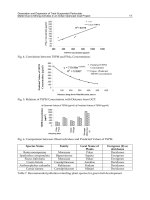
Table 1.
Emissions of particulate matter (PM), carbon
monoxide (CO), reactive nitrogen oxides (NO
x
),
volatile organic compounds (VOC), and sulfur dioxide
(SO
2
) in Santiago. Unit: 10
3
tons per year. Source:
CONAMA-RM, 1997.
In the near future, photochemical pollution will
also require of environmental information systems
with prognostic and diagnostic capabilities. The
system we describe (DYMOS) might contribute in this
respect, broaden up the available battery of modeling
tools. The first steps towards the implementation of
this tool are presented.
DISPERSION MODELING IN SANTIAGO
In Chile, the models most frequently applied for
environmental assessments are Gaussian models
developed by the Environmental Protection Agency of
the United States. The majority of such applications
Source PM CO NO
x
VOC SO
2
Stationary 3 4 11 1 17
Mobile 2 225 30 22 3
Other 37 16 3 39 1
Total 42 245 44 62 21
consider the dispersion of pollutants in the
surroundings of stationary sources, mainly within the
intensive copper mining industry. These tools are, of
course, inadequate for assessing the severe air
pollution problems that affect Santiago. Such urban
and regional air pollution problems involve several
spatial and temporal scales for which local, mesoscale
and synoptic transport patterns must be considered.
Chemical and physical transformations occurring
within these temporal and spatial scales must also be
taken into account for such problems.
In the 80's and in the first half of the 90's, several
initiatives, mostly developed within the universities,
approached different aspects of the dispersion of
pollutants in Santiago. Some work was made in
describing the meteorological features that control the
dispersion of pollutants in the area (Ruttlant and
Garreaud, 1995; Ulriksen, 1993). A few attempts were
made for implementing models to assess the
dispersion of quasi-inert tracers such as carbon
monoxide (Ulriksen, Rosenbluth and Muñoz 1992).
Since the mid 90's, under the National Commission
for the Environment (CONAMA), strong efforts have
been made for establishing emission inventories,
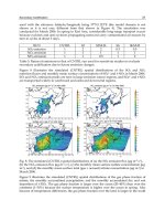
meteorological and air quality networks. Air quality
data has been monitored regularly ever since in
Santiago (see Figure 1). The air quality stations have
been placed to assess, mainly, health effects due to air
pollution in Santiago. Also, several monitoring
campaigns have been made (e.g., Artaxo, 1998). In
addition, a network of meteorological stations has been
put in place. The meteorological network (ca. 22
stations) was designed to capture meso-scale
meteorological features induced by complex
topography in the area.
A complete emission database has been developed
for the Metropolitan area of Santiago (REF CONAMA
RM). All this data begins to make it possible the
meaningful modeling of applications for meso and
regional scale problems. An information system that
includes a dispersion model for inert tracers has been
applied for assessing the dispersion of CO and PM10
on the urban scale. Also, a meso-scale meteorological
model has been implemented for Santiago (CENMA,
1999). A first attempt to assess the regional distribution
of, mainly, oxidized sulfur by means of a transport
model fed with meteorological fields calculated by a
limited area model has been recently presented
(Gallardo et al., 1999; Robertson et al., 1999). Also, at
the University of Chile a regional meteorological
model, which may provide useful input data for
dispersion applications, has been implemented
(Garreaud, pers. communication).
It must be pointed out that the majority of the
ongoing modeling efforts and initiatives are strongly
linked to international cooperation agreements. This
helps in creating the required local know-how in
atmospheric chemistry, meteorology and informatics
for approaching the increasing demands for reliable
environmental modeling applications in Santiago and
elsewhere in Chile. In the next section, a modeling
system (DYMOS) designed to assess photochemical
processes is presented. This tool, that has the necessary
functionalities for simulation, prediction and
visualization of air pollution, must be considered as
complementary to the available models and as a
contribution that enlarges the battery of tools for
decision making and research in atmospheric
modeling in Chile.
THE DYMOS SYSTEM
At GMD FIRST the DYMOS system has been
developed (Sydow et al. 1998), a parallelly
implemented air pollution simulation system for
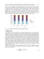
Figure 1.
City of Santiago (33.5ºS, 70.8ºW) and location
of the monitoring stations. Source: Servicio de Salud
Metropolitano del Ambiente (SESMA).
mesoscale applications. DYMOS consists of different
meteorology/transport models for different
application purposes including an air chemistry model
for the calculation of photochemical oxidants like
ozone. The core of the model system is formed by a
hydrostatic mesoscale Eulerian model with a low
vertical resolution for fast operational forecast tasks
(enhanced version of REWIMET, Heimann, 1985) and a
non-hydrostatic mesoscale Eulerian model with a high
vertical resolution and complex parameterization
facilities (enhanced version of GESIMA, Kapitza and
Eppel, 1992). In addition, Eulerian and Lagrangian
transport models are included within DYMOS. The air
chemistry model CBM-IV (Gery, Whitten, and Killus,
1988) is dealing with 34 species in 82 reaction equations
for simulating the photochemical processes in the
lower atmosphere.
Using the DYMOS system, analyses can be
performed regarding winter smog (high concentrations
of inert pollutants), summer smog (high concentrations
of ozone and other photochemical oxidants), and
single components (e.g. heavy metals, benzol,
radioactive or antigenic substances). In addition to
providing a dynamic emission source for the smog
forecast simulations, traffic flow modeling has become
a research field within DYMOS in its own right.
Emphasis is put on the analysis of critical states in
urban traffic systems. Due to the research work with
basic character carried out in DYMOS, a foundation
has been set for further, more applied projects.
Various case studies of summer smog conditions in
urban areas have been carried out using the DYMOS
system. The Department of Environment of the Berlin
state government and the Ministry for Environment of
the state Brandenburg commissioned summer smog
analyses for the results of the FLUMOB measuring
campaign carried out in July 1994. Greenpeace
commissioned an analysis of the influence of emissions
caused by traffic in Munich on the ozone concentration
in the Munich area. The analysis was performed for a
typical mid-summer day in 1994. Within the subproject
PATRIC the DYMOS system coupled with an Petri-net-
based traffic flow model was used to analyze the traffic
induced air pollution of the City of Budapest.
In order to inform the public about ozone
concentrations, the DYMOS system is currently in use
for the operational daily forecast of near surface ozone
concentrations in the Berlin-Brandenburg region
(Mieth, Unger, and Sydow, 1998). In cooperation with
the Department of Environment of the Berlin state
government, the Institute of Meteorology of the Free
University of Berlin and Inforadio Berlin, the predicted
concentrations are presented as raster images for
defined day times and as MPEG movie for the whole
day and can be found on the WWW (http://
www.first.gmd.de/ozon/).
DYMOS SYSTEM IN CHILE: FIRST STEPS
The first steps towards the implementation of a set-
up of the DYMOS system for simulating and
visualizing atmospheric pollution in Santiago have
started to be taken.
In order to apply the system DYMOS to forecast
the level of pollutants in the Metropolitan region of
Santiago, it has been judged to be necessary, according
to the experience with DYMOS, to divide this area into
a network of square grids, each of them with an area of
4 km². After this, it is necessary to provide three kinds
of data for each grid: static data (elevation), slowly
varying data (land use) and rapid varying data
(emission and meteorological information).
The set-up considers a domain of 54 km in the east-
west direction and by 86 km in the north-south
direction. Initially, the vertical resolution is not
specified. It includes 1.161 grids-points of 2x2 km²,
covering the urban area of Santiago. This area was
chosen in a first step because that is the area for which
data is available. In a second phase, for photochemical
simulations probably a larger domain would be
required, one considering and the big mountains
around the city, because they will certainly affect the
calculations, at least when calculating the
meteorological fields.
The static data and the slowly varying data were
determined by using satellite photographs of the
domain. They were obtained from the “Remote
Perception Center” of the Catholic University of Chile.
From them, and for each grid, an average elevation and
the percentage of water, meadows, forest, suburban
and urban area were computed.
As we mentioned before, the rapid varying data
includes emissions and meteorological information.
Emission data of nitrogen oxides (NO
x
), carbon
monoxide (CO) and volatile organic compounds
(VOC) from industries, houses and vehicles are
included. Annual averages have been provided by the
metropolitan branch of CONAMA, CONAMA RM,
(REF CONAMA-RM). On the basis of this information,
we are now working on estimating emissions per day
and per month. The Transportation Engineering
Laboratory of the Catholic University of Chile is
providing information about vehicle emissions in
several places in Santiago. By applying a
transportation model, ESTRAUSS, to these data, it is
possible to obtain an estimate of vehicle emissions in
every street in Santiago.
Meteorological data to initialize the model, i.e. air
temperature, winds, cloud-coverage, etc. will be
obtained from the observations provided by the
meteorological network of the Santiago basin and by
the European Center for Medium-Range Weather
Forecasts (ECMWF).
REFERENCES
Aceituno, P., 1988: On the functioning of the southern
oscillation in the South American sector: part I surface
climate. Mon. Wea. Rev., 116, 3, 505-524.
Artaxo, P., 1998: Aerosol characterization study in
Santiago de Chile wintertime 1998. Part of the study:
“Caracterizacion Fisicoquimica del Material
Particulado Inorganico Primario. Distribucion por
Tamano y Modelo Receptor”. Comision Nacional del
Medio Ambiente, Region Metropolitana de Santiago.
Cassmassi, J., 1999: Improvement of the forecast of air
quality and of the knowledge of the local
meteorological conditions in the Metropolitan region.
Technical report 2. Comision Nacional del Medio
Ambiente, Region Metropolitana de Santiago.
CENMA, 1999: Desarrollo de capacidades de
modelamiento atmosferico. Informe final 1999".
Comision Nacional del Medio Ambiente.
CONAMA-RM, 1997: Plan de prevencion y
descontaminacion atmosferica de la Region
Metropolitana. Comision Nacional del Medio
Ambiente, Region Metropolitana de Santiago.
Gallardo, L., Olivares, G., Aguayo, A., Langner, J,
Braahus, B., 1999: Regional dispersion of oxidized
sulfur over central Chile: A summer case. Comision
Nacional del Medio Ambiente.
Gery, M.W.; G.Z. Whitten and J.P. Killus. 1988.
“Development and Testing of the CBM-IV for Urban
and Regional Modeling.” US Environmental Protection
Agency, EPA-600/3-88-012, USA.
Heimann, D. 1985. “Ein Dreischichten-Modell zur
Berechnung mesoskaliger Wind- und Immissionsfelder
über komplexem Gelände.” Ph.D. thesis, University of
Munich, Germany.
Kapitza H. and D.P. Eppel. 1992. “The Non-Hydrostatic
Mesoscale Model GESIMA. Part I: Dynamic Equations
and Tests.” Beitr. Phys. Atmosph., no. 65 (May): 129-146.
Mieth, P.; S. Unger; and A. Sydow, 1998. “Short Term
Ozone Forecasting with an Eulerian Dispersion
Model”, Systems Analysis Modelling Simulation, Vol. 32,
No. 1-2, 73-80.
Mieth, P.; S. Unger; and M.L. Jugel, 1998. “An
Environmental Simulation and Monitoring System for
Urban Areas”, Transactions of the Society for Computer
Simulation International, Vol. 15, No. 3, 115 - 121.
Robertson, L., Langner, J., and Engardt, M. 1999: An
eulerian limited-area atmospheric transport model. J.
Appl. Met. 38, 190-210.
Rutllant, J. & Garreaud, R., 1995: Meteorological air
pollution potential for Santiago Chile: towards an
objective episode forecasting. Env. Monitoring and
Assessment, 34: 223-244.
Sydow, A.; T. Lux; H. Rosé; W. Rufeger; and B. Walter,
1998. “Conceptual Design of the Branch-Oriented
Simulation System DYMOS (Dynamic Models for
Smog Analysis).” Transactions of the Society for Computer
Simulation International, Vol. 15, No. 3, 95 - 100.
Ulriksen, P., 1993: Factores meteorologicos de la
contaminacion atmosferica de Santiago. In
“Contaminacion atmosferica de Santiago, estado actual
y soluciones”. Sandoval, H., Prendez, M. y Ulriksen, P.
Editores. Editora e impresora Cabo de Hornos S.A.
Ulriksen, P., Rosenbluth, B and Munoz, R., 1992:
Caracterizacion de episodios de contaminacion
atmosferica en Santiago y su pronostico mediante
modelos estocasticos. Informe final, proyecto
FONDECYT 1192-91.