Water Conservation Part 2 docx
Bạn đang xem bản rút gọn của tài liệu. Xem và tải ngay bản đầy đủ của tài liệu tại đây (3.65 MB, 15 trang )
Water Conservation
6
Design criteria used when installing the water ponding dikes at the Jornada are specified by
Tromble (1983). These criteria varied because of the characteristics of the individual site.
Dikes were installed on fine to medium textured soils where the soil sealed rapidly during
rainfall events thereby producing surface runoff. Furthermore, the dikes were placed in
areas of “wasteland” supporting little or no vegetation (similar to the “scalds” in Australia).
Dikes were placed starting at the highest place on the slope and working downslope. The
direction of water flow from one dike to the next was regulated by locating one end of the
dike higher than the other end so that water flowed out the lower end of the dike once it
filled (Tromble, 1983). The distance between dikes was a function of the slope and expected
water ponding depth. Enough distance was left between dikes to provide a source area for
surface runoff water. Usually a 1:1 or 2:1 ratio of water runoff area to ponding area is
satisfactory on a scald area (Tromble, 1983), but other authors cite values of 5:1 to 25:1
depending upon local conditions (Vallentine, 1989).
Compared to the shallow water ponding dikes, much deeper ponds or lakes are also necessary
in rangelands for watering livestock as well as for providing fringe benefits to wildlife.
Placement of these water sources depends not only upon water availability, but also on animal
numbers, available forage, soil properties, and abiotic factors. Many approaches to providing
water have been tested on rangelands. The two most usual developed water sources are from
drilled, deep water wells and earthen dams that cause the formation of stock ponds. Early in
the 20
th
century, it was recognized that competition to use reliable well water would become
intense and that earthen dams to capture surface runoff would help reduce the pressure on
well water utilization (Talbot, 1926). Simple, small earthen dams placed across drainage ways
can provide open water storage during the rainy season and sometimes year round. This
ancient technique has been used ubiquitously in arid regions and continues to be used
throughout the world today. The ponds formed behind these earthen dams are, obviously,
much deeper than behind shallow water ponding dikes.
In times of drought, stock ponds can dry up and the more reliable water source from deep
wells is commonly relied upon. But for large portions of the year, especially in average to
wet years, it is best to restrict deep well pumping to conserve the limited groundwater
resources. In the same general water harvesting family that includes water ponding dikes
and water spreaders, livestock water supply schemes can be very simple and are generally
referred to as dirt tanks, stock tanks, or stock ponds.
In sparsely settled rangeland, especially in arid and semiarid regions where vegetation cover is
limited, arguments for expensive solutions to make water available are usually difficult to
justify. Reasons for deciding on earthen dam stock ponds are numerous, but the primary
reason is that they are affordable to construct. Stock tanks are especially suitable in closed
drainage, arid basins where flow in channels never leaves the basin, except by infiltrating into
the stream channel bed and subsequently evaporating. By concentrating the flow behind
earthen dams, the surface water area is small, thereby reducing both infiltration and
evaporation. When surface soils in a watershed (and also used in construction) have a high
percentage of clay and silty loams, infiltration rates tend to be low and surface runoff is
increased. The use of stock ponds as the primary source of surface water reduces the use of
well water with a more expensive infrastructure required for establishment. In most arid
regions today, the natural recharge by precipitation is unable to provide replenishment of
ground water because of an increasing deficit between recharge and pumping, both historic
and present day (Giordano, 2009). Also, simple earthen dams and ponds last a long time with
minimal maintenance. At the Jornada 77 stock ponds exist over the 783 km
2
area, most of
which were constructed by Civil Conservation Corps labor in the 1930s (see Figures 4 and 5).
Review of Water-Harvesting Techniques to
Benefit Forage Growth and Livestock on Arid and Semiarid Rangelands
7
Fig. 4. Construction of stock water storage tanks at the Jornada Experimental Range using
three-horse Fresno teams on Big Meadows tank by the Civilian Conservation Corps (CCC)
in April 1934.
Fig. 5. Use of mechanized earth moving equipment during construction of Big Meadows
tank at the Jornada Experimental Range in 1934. New equipment and the availability of the
CCC labor force were some of the reasons for the revitalization of water harvesting on
rangelands.
Water Conservation
8
Fifty-five percent of these stock ponds had to be renovated approximately 50 years later in
1984. Maintenance costs for the original stock ponds during the 50 year period before
renovation was minimal due to limited erosion of structures and slow sedimentation rates
behind the earthen dams.
3. Rationale for revisiting use on rangelands
Though an ancient practice, there are several reasons why water harvesting has been nearly
abandoned as a management tool across most land areas of the southwest U.S. as well as
other arid to semiarid regions of the world. These reasons include: 1) a perceived notion that
installation of water harvesting infrastructure is too expensive in relation to the resultant
benefits, 2) legislative restrictions and their associated costs for applications in the public
land ownership landscapes of the western U.S., 3) a persistent belief that large spatial scale
installations are too difficult to implement and maintain, or 4) a lack of knowledge about the
effectiveness of water harvesting as a legitimate management practice. In reality, installation
of simple systems are not that expensive, minimal maintenance is all that is needed to
maintain function, and water harvesting can be effective if given enough time to be
activated in regions of sparse, sporadic, and spatially widespread rainfall. Though there
may be a lack of communication about the details of these structures, this could be rectified
by more effective documentation and educational outreach programs. There is also the
possibility that there are falsely held ideas that these methods are only suitable for areas of
extreme poverty and with little access to more modern technologies. However, the water
conserving nature of these water harvesting methods should dispel this idea. As water
scarcity continues to pressure our increasing population, the importance of water
conservation through water harvesting will be much more relevant (Giordano, 2009).
To some degree, arid land water managers may have overlooked the fact that there were
installations of numerous rangeland water harvesting treatments in the western U. S. and
other parts of the world in the 1930-1970s. Results from these applications are useful in
improving the understanding of the advantages of employing water harvesting
technologies. The desirability of these water harvesting techniques should increase in the
future under conditions of climate change and increasing climate variability. New Mexico,
because of its southerly location in the United States, has already experienced warmer
temperatures (+1° C in winter and +2° C in summer) as a result of the ongoing climate
change (Watkins, 2006). Diffenbaugh et al. (2008) also noted that the southwestern U.S.
stands out as a regional hot spot for 21
st
Century climate change. It is possible that certain
locations of the arid southwestern U. S. will not only experience warming temperatures, but
also declining rainfall amounts, thus, greatly increasing the relevancy of water harvesting
approaches. Although some areas of the West may receive reduced annual rainfall, they
could also experience increases of convective rainfall events. As a result, the water
harvesting approaches which are effective during intense rainfall can be used to offset the
effects of warmer temperatures and increased evaporative losses that would be expected.
4. Methods of rangeland water harvesting
The basic goal of water harvesting on rangeland is to intercept the flow of surface water,
either as overland flow or as channel flow. A variety of surface structures have been used in
the past, but use of earthen dikes, berms or dams has been most popular because of
Review of Water-Harvesting Techniques to
Benefit Forage Growth and Livestock on Arid and Semiarid Rangelands
9
simplicity, effectiveness, and relative low cost of both installation and subsequent
maintenance. The concept of water ponding is to use a dike or berm to hold the water in
such a manner so that it cannot flow off the surface of the soil unless the capacity of the dike
is exceeded (Miller et al., 1969). When a pond forms behind the dike, the infiltration process
has an extended time period to operate and replenish the soil moisture reservoir.
Furthermore, by slowing down the flow of water, the amounts of infiltration and soil
moisture are increased. Because of the increase in soil moisture, plant growth can be
enhanced, either from existing plants, germination and resulting establishment, native seed
banks, or planting of seeds during construction of the dikes. Water harvesting methods to
supply livestock drinking water employ the same general techniques used in water ponding
dikes. In this case, the collected water is stored in tanks or ponds (Frasier, 2003).
Although not serving exactly the same function as water ponding dikes, earthen berms are
also installed across large areas upslope of downstream areas that are prone to flooding. The
purpose of these berms is to slow down surface runoff, promote infiltration, control erosion,
reduce flash flooding peaks, and even out the flows reaching the stream channel so that
adverse impacts on downstream reservoirs are minimized (Caird & McCorkle, 1946;
Baquera, 2010).
Water spreaders used on rangeland usually cover larger areas than water ponding dikes
and are generally of two kinds. The first is designed as a system of dikes or berms
constructed to automatically divert storm flows in gullies and spread them over the adjacent
rangeland to promote the growth of forage (Miller et al., 1969). Such water spreading
systems can also be used effectively with irrigated agriculture. The second type of spreader
is more specific and requires a water storage reservoir that retains water during storm
runoff events. When a certain volume of water has been stored, the entire stored volume is
released in a quick burst to run down a restricted flow path like a modified arroyo system.
Earthen berms are used to cause the discharged water to flow through a more sinuous
channel, longer than the natural arroyo channel. The resulting larger volume of water has a
greater length to follow while infiltrating into the channel bottom of the target area. This
also promotes increased soil moisture which can enhance plant growth.
Useful forage plants can be seeded along the flow path to produce an increase in forage for
livestock and wildlife.
To increase the water volume available for release, flow in stream channels of adjacent
watersheds can be diverted to the storage reservoir to more rapidly increase the stored
water volume. The soil berms are sometimes reinforced with concrete, especially at bends in
the sinuous channel, to prevent bank erosion due to the transport of high flows over a short
period of time.
Although the concept of shallow water ponding dikes to enhance soil moisture and,
subsequently, increase ground cover and forage for livestock and wildlife is simple in
concept, many factors enter into their exact placement in arid and semiarid regions. The
overriding purpose is to slow down surface runoff, and one consideration is to determine
areas with significant overland flow. This can be done by observing such flows in the field
during or after heavy rainfall events, but this requires on-the-ground observations during
what may be rare runoff events. It may be more useful to employ remote sensing data either
by observing the evidence of overland flow immediately after a rainfall event, or by
recognition of overland flow paths during post-rainfall dry periods that remain highlighted
for several weeks because of remnant surface soil moisture patterns.
Water Conservation
10
Figure 6 is an aerial photograph at the Jornada in southcentral New Mexico in October 2006
which shows runoff flow paths through the desert (after rainfall events) as darker areas where
surface soil moisture is greater. From a landscape perspective, the use of remote sensing
allows a more complete understanding of the landscape units generating surface runoff. This
more detailed spatial analysis improves the actual placement of individual dikes.
Fig. 6. Aerial photograph over the Jornada in October 2006 showing runoff flow paths after
rainfall events at 25 cm resolution. Flow paths are darker because of an increase of surface
soil moisture following overland flow.
The type of soils where dikes are constructed needs to be considered because of the differential
amounts of overland flow that can be generated by different soils. Fine to medium texture soils
generally produce significant surface runoff from intense rainfall that can be intercepted by
water ponding dikes (Miller et al., 1969). Sandy soils allow higher rates of infiltration, generate
too little surface flow, and are, therefore, unsuitable for producing enough water for
installation of dikes. Clay, silty-clay, or silty loam soils are generally suitable soil types for
water ponding dikes. Once the pond is formed behind a dike, it is important to have the water
infiltrate into the soil and be stored in the soil moisture reservoir for plant uses. Water
harvesting dikes also promote sediment deposition in the ponding area. Generally, this can
result in increases of the clay, silt, and/or loam contents of the soil which may allow more
stored soil moisture and greater vegetation production.
Mean annual and seasonal rainfall and the type and intensity of storms are important
rainfall characteristics for designing any water harvesting system. According to Bennett
(1939), if the mean annual rainfall is from 200-355 mm, the conditions are ideal for plant
growth for rangelands using water ponding. If a large portion of the rainfall occurs in
Review of Water-Harvesting Techniques to
Benefit Forage Growth and Livestock on Arid and Semiarid Rangelands
11
convective rainfall events in summer, the chance of successful water ponding increases
because rainfall rates are more likely to exceed infiltration rates and produce more runoff
than areas with many, low intensity storms. If the mean annual rainfall exceeds 355 mm,
then water harvesting for supplemental feed and cultivated crops also has a high probability
of success (Bennett, 1939). These are characteristics present in the southwest U.S. as well as
in the vast arid to semiarid regions of the world.
When completed, the actual water ponding dike should have a round rather than a V-
shaped top because the rounded crest is less affected by large animal impacts, such as
livestock trampling. Broad-based dikes with a bottom width of 2-3 m are more stable than
narrow dikes. Dike lengths at the Jornada ranged from 50-150 m (Rango et al., 2006).
Periodic maintenance to repair breaches in dikes is recommended (Stokes et al., 1954). For a
variety of non-technical reasons, the Jornada dikes were not originally thought to be effective,
and the dikes have not received any maintenance since being constructed in 1975. Although this
is not the optimum situation, the dikes are still performing their water ponding and increasing
vegetation functions despite the development of breaches through the earthen dikes.
The soil type where a stock pond is to be constructed should possess silt and clay
components, if possible, because of the capability of these soil textures to be compacted to
increase the stock pond bottoms resistance to infiltration. However, construction on sandy
soils is even possible. The USDA Forest Service (1939) suggested a way to make stock pond
bottoms more impervious without using fine grain soils or other construction techniques.
Salt was placed on the dry bottoms of the stock ponds to attract cattle. In a short time, the
cattle would trample the soil of the future pond bottom into a hard compact state, and the
stock pond would be nearly water tight when filled.
At the Jornada, when the first of the CCC stock tanks was built, the construction was
accomplished using both five teams of three horses each with one Fresno plow (see Figure 4)
and one of the first motorized caterpillars (see Figure 5). Today earthen dams used to form stock
ponds are constructed around the world using anything from modern earth moving equipment
to a large number (133) of men and women working with handheld tools (Botts, 2009).
5. Discussion
5.1 Water ponding dikes
Figure 7 shows a temporal sequence of vegetation growth behind the a) Ace Tank dikes and
b) the Taylor Well dikes at the Jornada. When records were being kept of ponding events
behind the dikes (1978-1981), the Ace Tank dikes averaged 12 ponding events per year,
whereas the Taylor Well dikes averaged 11 per year. In the case of both sets of dikes, the
response of vegetation behind the dikes (shown in darker brown or red tones) to ponded
runoff water was not immediate, taking about 10-12 years to react to sporadic precipitation
events typical of the southwest U.S. These delayed responses are to be expected in dry
regions whereas in more humid regions, the response times may be 1-2 years. A similar
delayed response was detected by Peterson & Branson (1962) on water harvesting structures
installed by the CCC between 1934 and 1942 in southwestern New Mexico and southeastern
Arizona. Initial surveys of vegetation growth showed little response, but subsequent
surveys 12 years later revealed that vegetation growth was substantially improved. In the
arid Southwest, it will take longer for the characteristic rainfall events (high intensity but
widely distributed storms) to occur in the vicinity of the collecting area for water ponding
dikes and still longer for extensive vegetation growth to occur.
Water Conservation
12
Fig. 7. A sequence of vegetation growth from construction in 1975 to 2006 using aerial
photography for a) the Ace Tank dikes and b) the Taylor Well dikes at the Jornada.
Review of Water-Harvesting Techniques to
Benefit Forage Growth and Livestock on Arid and Semiarid Rangelands
13
Soil moisture was measured from the time of installation of the Jornada dikes in 1975 until
when measurements were terminated in the mid 1980s. Tromble (1982) compared the soil
moisture profile in July 1979 (after the dikes had been in place for four years) for the Taylor
Well dikes (7.5 cm) and the Ace Tank dikes (15 cm). Although rainfall totals are similar for
the Ace and Taylor dikes, the greater water ponding depth of Ace (due to the higher dikes)
has produced a soil moisture profile difference. Figure 8 shows that the control area was
uniformly dry down to 180 cm depth whereas the Taylor dikes were much wetter at the
surface and gradually dried out with depth. The Ace dikes had uniformly greater soil
moisture down to 180 cm (Tromble, 1982).
Fig. 8. Soil water profiles for control, 7.5-cm dikes, and 15-cm dikes on the Jornada
Experimental Range on July, 1979 (from Tromble, 1982)
Associated with increases in soil moisture, Miller et al., (1969) have reported increased
forage yields exceeding 1 ton/acre (2240 kg/ha) in response to water spreading
treatments. Yields were reduced if water ponded without infiltrating for long periods of
time. Branson (1956) reported that forage yields on water ponding dikes (as part of a
water spreader system) were 2.6 times the yields on controls in a Montana experiment.
Houston (1960), also working in Montana, reported an increase in herbage yields of 62%
for water draining across rangelands, and a yield increase of 189% for rangeland where
water was allowed to pond and infiltrate. Hubbell & Gardner (1950), experimenting in
New Mexico, reported herbage yields increased by water spreading by 4-9 times and
Hubbard & Smoliak (1953) reported herbage increases exceeding these yields. In the
more recent water ponding experiments at the Jornada, Tromble (1984) reported that the
7.5 cm dikes resulted in a 2.4 – 6.0 fold increase in forage production over controls,
depending on year and the location behind the dike. In all the water ponding or
spreading experiments, it seems that increases in soil moisture and forage yield are
consistent across the western U.S.
Water Conservation
14
Few investigators have documented quantitative results and the costs and benefits
associated with water harvesting for rangeland. Where this has been done, the investigators
are usually more specific about costs but less so about the benefits. Investigators generally
state that the costs are out-weighed by the benefits which are usually an increased amount
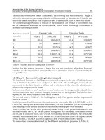
of forage or increased plant species diversity and subsequent ground cover. Table 2 lists
authors who have included costs (in U.S. $, for 2010) associated with installation of dikes or
spreaders. Generally, the cost of construction of water ponding dikes is less than
construction of water spreaders. The dikes used in water spreaders by Hubbard and
Smoliak (1953) and Monson & Quesenberry (1958) range from 1.5-2.5 ft. (46-76 cm) high,
whereas dikes employed at the Jornada ranged from 3-12 in. (7.5-30 cm) high. In order to
estimate the costs of the Jornada dike installation (because no records were kept during
installation), the dikes would be expected to cost about 50% of the average cost in Table 2
[0.5 x $32.48 = $16.24/acre ($40.10/ha)] in U.S. dollars) because the Jornada [average dike
height = 7 in (18cm)] required much less construction effort than the ones reported in Table
2. To estimate the cost of installing dikes over a much larger area, eleven pastures at the
Jornada have been identified as potentially feasible for trapping and ponding surface runoff
because of favorable soil type and evidence of overland flow after convective storms. About
20% of the area in those pastures would be treated or about 3,641 acres (1,473 ha). The cost
for water ponding dike installation would be approximately $59,000. Unfortunately, as with
other analyses of the benefits and practices which can enhance goods and services from
rangelands, we lack sufficient economic data for further cost/benefit calculations of the
potential water ponding treatments.
Investigators
Cost / acre
(1 ac = 0.405 ha)
Benefit
Cost When
Installed
Converted to
2010 $
Mooney & Martin (1956) $6.70 $53.13 % Increase hay
Hubbard & Smoliak (1953) $0.36 $2.90 % Increase herbage
Monson & Quesenberry (1958) $1.38 $10.29 % Increase herbage
Houston (1960) $2.35 $17.10
Monetary increase of
herbage/acre
Branson (1956) $9.96 $78.99 Increased herbage/acre
Average $32.48
Table 2. Cost associated with installation of water ponding dikes or water spreaders.
5.2 Stock ponds
The number of stock ponds to be constructed depends upon the type of livestock to be
grazed because of the distance that specific breeds of cattle typically graze away from a
water source varies. For example, comparison studies using Global Positioning System
(GPS) collars have shown that Mexican types and breeds of livestock such as the Criollo are
willing to travel longer distances (5.8 km vs 2.2 km) from water than British breeds (Angus)
when forage availability is limited. The Criollo will also travel to higher elevations than the
Angus to seek out forage (Peinetti et al, 2011). Results from these studies indicate that the
lighter, smaller Criollo breeds (~400 kg/animal) would probably be matched better than the
Review of Water-Harvesting Techniques to
Benefit Forage Growth and Livestock on Arid and Semiarid Rangelands
15
Angus breeds (~700 kg/animal) to the characteristics of desert rangelands (Peinetti et al,
2011). Designing stock water infrastructure for livestock breeds better suited to arid
environments will result in reduced operational costs and reduced environmental impacts.
For example, earlier studies by Herbel & Nelson (1966) found that Santa Gertudis cattle with
a heritage from a hot, arid environment traveled 4.7 km a day further than Hereford breeds
in search of forage. These cattle would seem to similarly disperse across the landscape like
the Mexican breeds and reduce severe impacts around water sources as well as in areas with
abundant forage.
When most of the stock ponds were constructed back in the 1930s at Jornada, a combination
of manpower, horsepower, and mechanized vehicles were used (see Figures 4 and 5). The
most usual stock tank is an earthen dam in a crescent shape that is constructed across an
established drainage way. When original construction was done in 1934, the average time
required for construction (with a crew of seven men, five Fresno teams of three horses each
and one plow team) was two working days of eight hours each (USDA Forest Service, 1939).
At that time the average cost of construction was $90 per stock tank ($1,450 in 2010). This
value is considered to be on the low end of the range of construction costs because of the
subsidized nature of using CCC labor. Construction costs in the same area of New Mexico
before CCC labor was available averaged $157 ($2,529 in 2010) (Talbot, 1926). This was for a
dirt tank that would store an average capacity of 220 m
3
of water. It is assumed that the
same basic stock tank would be constructed today but with more modern earth moving
equipment. The cost of the equipment would be higher, but the time for construction would
be reduced. In 1935, the cost of drilling a deep well needed to yield this amount of water
would be $2,833 ($44,524 in 2010 or more because the water table has continued to drop
since the 1930s resulting in the need for deeper wells).
6. Conclusions
Water harvesting is a methodology that has been used for over 9 millennia to concentrate,
collect, and distribute water that normally would be inaccessible for applications in irrigated
agriculture, individual domestic water supply, and rangeland management. Although used
widely for agriculture and domestic supplies, water harvesting is a management technique
seldom used for rangeland applications despite numerous positive results. It is possible that
the technique may be overlooked for a variety of possible reasons, the least compelling
being that it is an ancient method based on archaic technologies.
As more and more stresses are placed on our natural resources through effects of a growing
population, increased pressure on existing groundwater supplies, and climate change, a
renewed use of water harvesting would have positive outcomes. The simplest technique is
to use water ponding dikes which slow down surface runoff, allow infiltration and increase
soil moisture, and promote significant vegetation growth for habitat cover and forage. It is
recommended to use water ponding dikes because of the direct response: shallow water
ponds form after high intensity rainstorms, infiltration and soil moisture increase, and
growth of native vegetation (sometimes delayed for years because of the type and
distribution of rainfall experienced across an area) is enhanced. The advantages of water
ponding dikes are that they are simple to install, cost effective, and make use of water that
would be lost to evaporation.
The use of water ponding dikes also mimics nature in the way that banded vegetation is
arranged on the landscape: bare soil producing surface runoff after a storm, vegetation
Water Conservation
16
bands downslope slowing down and catching the surface runoff and increasing soil
moisture, and causing increased vegetation growth as if it was located in an area with a
higher rainfall. Future experiments are needed on larger areas to determine if these
rangeland treatments cause improved vegetation cover that can expand to (or at least be
stable over) even larger spatial extents. If water can be supplied effectively to the soil and
vegetation complex, such as through water harvesting, it is likely that rangeland restoration
projects will have an increased likelihood of success.
The use of stock tanks as water sources on rangeland for cattle grazing is a traditional
method that has one of the least expensive construction costs amongst a variety of possible
methods. In arid regions, it places reliance on trapping surface runoff that will otherwise be
lost back into the atmosphere through evaporation. By confining this surface runoff in a
pond with small surface area, and water depth of up to 2m, evaporation and infiltration
losses are both reduced over what would normally occur if the water was spread out and
infiltrated into a stream bed. The groundwater reservoir is not depleted until necessary, e.g.,
when severe drought years are encountered, and then well pumping would only be relied
upon when the pond becomes dry.
7. Acknowledgements
The authors would like to thank scientists and technicians at the Jornada who have
participated in rangeland remediation and water harvesting treatments. In particular, the
late Dr. Robert Gibbens was an important source of information about the water harvesting
research. His knowledge was invaluable for preserving a record of this type for future
rangeland researchers. The technical assistance of Bernice Gamboa and Valerie LaPlante in
preparing this manuscript is greatly appreciated.
8. References
Baquera, N. (2010) Characterization of Historical Water Retention Structures and
Assessment of Treatment Effects in the Chihuahuan Desert. Master of Science
Thesis, Department of Plant and Environmental Science, New Mexico State
University, Las Cruces, New Mexico, USA, 69 pp.
Bennett, H. (1939). Soil Conservation. McGraw-Hill Co., New York, New York. 993 pp.
Boers, T. & Ben-Asher, J. (1982). A Review of Rainwater Water Harvesting. Agricultural
Water Management, Vol. 5 pp. 145-158.
Botts, F., (2009). In: Excerpts from Journeys for a Witness by Florita Botts/ An earth Dam –
Handmade in Ethiopia.
Accessed 6-28-2010.
Branson, F. (1956). Range Forage Production Changes on a Water Spreader in Southeastern
Montana. Journal of Range Management, Vol. 9, pp. 187-191.
Branson, F.; Gifford, G.; Renard, K. & Hadley, R. (1981). Rangeland Hydrology, Range Science
Series, Kendall/Hunt Publishing Company, Dubuque, Iowa, 339 pp.
Bruins, H.; Evenari, M. & Nessler, U. (1986). Rainwater Harvesting Agriculture for Food
Production in Arid Zones: The Challenge of the African Famine. Applied Geography,
Vol. 6, pp. 13-32.
Caird, R. & McCorkle, J. (1946). Contour-Furrow Studies Near Amarillo, Texas. Texas Journal
of Forestry, Vol. 44, pp.587-592.
Review of Water-Harvesting Techniques to
Benefit Forage Growth and Livestock on Arid and Semiarid Rangelands
17
Caran, S. & Neely, J.(2006). Hydraulic Engineering in Prehistoric Mexico. Scientific American,
Vol. 295, pp. 78-85.
Critchley, W., K. Siegert, C. Chapman, and M. Finkel. 1991. A Manual for the Design and
Construction of Water Harvesting Schemes for Plant Production, AGL/MISC/17/91,
Food and Agriculture Organization of the United Nations, Rome.
Cunningham, G.; Quilty, J. & Thompson, D. 1974. Productivity of Water Ponded Scalds.
Journal of Soil Conservation, Soil Conservation Service of N.S.W, Vol. 30, Issue 4,
pp.185-200.
Diffenbaugh, N.; Giorgi, F. & Pal, J. (2008). Climate Change Hotspots in the United States.
Geophysical Research Letters, Vol. 35, L16709, doi:10.1029/2008GL035075.
Evenari, M.; Shanan, L. & Tadmor, N. (1982). The Negev: The Challenge of a Desert. Harvard
University Press, Cambridge, Massachusetts, USA, Second Edition, 437 pp.
Fidelibus, M. & Bainbridge, D. (1995). Microcatchment Water Harvesting for Desert
Revegetation. SERG Restoration Bulletin 5, SERG Soil Ecology and Restoration
Group, San Diego State University, San Diego, CA, 12 pp.
Frasier, G. (2003). Livestock, Water Harvesting Methods for Encyclopedia of Water Science,
Marcel Dekker, New York, pp. 593-595.
Frasier, G. & Myers, L. (1983). Handbook of Water Harvesting, Agricultural Handbook
Number 600, Agricultural Research Service, U.S. Department of Agriculture,
Washington, D.C., USA, 46 pp.
French, N. & Hussain, J. (1964). Water Spreading Manual, Range Management Re. 1, Pakistan
Range Improvement Scheme, Lahore, Pakistan.
Giordano, M. (2009). Global Groundwater Issues and Solutions. Annual Review of
Environment and Resources ,Vol. 34, pp. 153-178.
Hadley, R.; McQueen, I.; & et al. (1961). Hydrologic Effects of Water Spreading in Box Creek
Basin Wyoming. U.S. Geological Survey, Water Supply Paper 1532A, U.S.
Government Printing Office, Washington, D.C. 47 pp.
Havstad, K.; Huenneke, L. & Schlesinger, W. (2006). Structure and Function of a Chihuahuan
Desert Ecosystem: the Jornada Basin Long-Term Ecological Research Site, Oxford
University Press, New York, New York, 465 pp.
Heady, H. & Child, R. (1994). Rangeland Ecology and Management, Westview Press, Boulder
Colorado, 519 pp.
Herbel, C. & Nelson, A. (1986). Activities of Hereford and Santa Gertrudis Cattle on a
Southern New Mexico Range, Journal of Range Management, Vol. 19, pp. 173-176.
Holechek, J.; Pieper, R. & Herbel, C. (1995) Range Management: Principles and Practices,
Prentice Hall, Englewood Cliffs, New Jersey, 526 pp.
Houston, W. (1960). Effects of Water Spreading on Range Vegetation in Eastern Montana.
Journal of Range Management, Vol 13, pp. 289-293.
Hubbard, W. & Smoliak, S. (1953). Effects of Contour Dykes and Furrows on Short-Grass
Prairie. Journal of Range Management Vol. 6, pp.55-62.
Hubbell, W. & Gardner, J. (1950). Effects of Diverging Sediment Laden Runoff from Arroyos to
Range and Crop Lands. U.S. Department of Agriculture. Tech. Bull. 1012. 83 pp.
Hudson, N.W. (1987). Soil and Water Conservation in Semi-Arid Areas. FAO Soils Bulletin 57,
Food and Agriculture Organization of the United Nations, Rome.
Lowdermilk, W. (1960). The Reclamation of a Man-Made Desert. Scientific American
Vol. 202,
pp. 55-63.
Miller, R.; McQueen, I.; Branson, F.; Shown, L. & Buller, W. (1969). An Evaluation of Range
Floodwater Spreaders. Journal of Range Management Vol. 22, pp. 246-247.
Water Conservation
18
Monson, O. & Quesenberry, J. (1958). Putting Flood Waters to Work on Rangelands. Montana
Agricultural Experiment Station Bull. 543, 39 pp.
Mooney, F. & Martin, J. (1956). Water Spreading Pays-A Case History from South Dakota.
Journal of Range Management Vol. 9, pp. 276-278.
Peinetti, H.; Fredrickson, E.; Peters, D.; Cibils, A.; Roacho-Estrada, J. & Laliberte, A. (2011).
Foraging behavior of heritage versus recently introduced herbivores on desert
landscapes of the American Southwest. Ecosphere Vol. 5, Issue 2, Article 57.
(doi:10.1890/ES11-00021.1)
Peterson, H. & Branson, F. (1962). Effects of Land Treatments on Erosion and Vegetation on
Rangelands in Part of Arizona and New Mexico. Journal of Range Management, Vol.
15, pp. 220-226.
Prinz, D., and A.H. Malik. 2002. Runoff Farming. WCA InfoNet, Rome, Italy, 39 pp.
Rango, A.; Tartowski, S.; Laliberte, A.; Wainwright, J. & Parsons, A. (2006). Islands of
Hydrologically Enhanced Biotic Productivity in Natural and Managed Arid
Ecosystems, Journal of Arid Environment, Vol. 65, pp. 235-252.
Renner, H. & G. Frasier, G. (1995). Microcatchment Water Harvesting for Agricutlural
Production: Part I: Physical and Technical Considerations. Rangelands, Vol. 17(3),
pp. 72-78.
Stokes, C.; Larson, F. & Pearse, C. (1954). Range Improvement Through Waterspreading. U.S.
Government Printing Office. Washington, D.C. 36 pp.
Talbot, M. (1926). Range watering places in the Southwest. Department Bulletin, U.S.
Department of Agriculture, Washington, D.C., 43 pp.
Tongway, D.; Valentin, C. & Seghieri, J. (2001). Banded Vegetation Patterning in Arid and
Semiarid Environments. Springer-Verlag, New York, New York. 251 pp.
Tromble, J. (1982). Water Ponding for Increasing Soil Water on Arid Rangelands. Journal of
Range Management, Vol. 35, pp.601-603.
Tromble, J. (1983). Rangeland Ponding Dikes: Design Criteria. Journal of Range Management,
Vol. 36, pp. 128-130.
Tromble, J. (1984). Concentration of Water on Rangeland for Forage Production. Second
Intermountain Meadow Symposium Proceedings, pp. 143-147. Gunnison, Colorado,
Special Series No. 34
USDA Forest Service. (1939). Notes from the Jornada Experimental Range. Jornada Water
Developments, Las Cruces, New Mexico, 2 pp.
Valentine, K. (1947). Effect of Water-Retaining and Water-Spreading Structures in Revegetating
Semidesert Range Land. New Mexico College of A. & M.A., Agricultural Experiment
Station Bulletin 341, 22 pp.
Vallentine, J. (1989). Rangeland Development and Improvements. Academic Press, San Diego,
California, 524 pp.
Warren, J. (1965). The Scalds of Western New South Wales – a Form of Water Erosion.
Australian Geographer, Vol. 9, pp. 282-292.
Watkins, A. (ed) (2006). The Impact of Climate Change on New Mexico’s Water Supply and Ability
to Manage Water Resources, New Mexico Office of the State Engineer, Santa Fe, New
Mexico, USA.
Zaunderer, J. & Hutchinson, C. (1988). A Review of Water Harvesting Techniques of the Arid
Southwestern U.S. and North Mexico. Working paper for the World Bank’s sub-
Saharan water harvesting study.
2
Importance of Percolation Tanks for Water
Conservation for Sustainable Development of
Ground Water in Hard-Rock Aquifers in India
Shrikant Daji Limaye
UNESCO-IUGS-IGCP Project 513“GROWNET”
International Association of Hydrogeologists (IAH)
1
Ground Water Institute
2
Association of Geoscientists for International Development (AGID)
3
International River Foundation, Brisbane,
1
India
2
UK
3
Australia
1. Introduction
Development of a natural resource like ground water is a concerted activity towards its
sustainable use for human benefit. The concept of sustainable use is related to various
factors like the volume of water storage in the aquifer, annual recharge or replenishment,
volume of annual pumpage for the proposed use, benefit/cost ratio of the proposed use,
and environmental impacts of the proposed use.
Hard rock aquifers in this paper mean the non-carbonate, fractured rocks like the
crystalline basement complex and metamorphic rocks, which cover an area of about
800,000 sq. Kms. in central and southern India. Basalts of western India also known as the
Deccan traps of late Cretaceous to early Eocene period are also included as a special case.
Deccan traps comprise hundreds of nearly horizontal, basaltic lava flows in a thick pile
and cover around 500,000 sq. kms of western India. (Fig. 1a and 1b) This pile was not
tectonically disturbed after consolidation and a hand specimen does not show any
primary porosity due to the non-frothy nature of the lava. (Adyalkar & Mani 1971)
Hydrogeologically, the Deccan traps have low porosity and are therefore, akin to
fractured hard rock aquifers.
The most significant features of the hard rock aquifers are as follows:
1. A topographical basin or a sub-basin generally coincides with ground water basin.
Thus, the flow of ground water across a prominent surface water divide is very rarely
observed. In a basin, the ground water resources tend to concentrate towards the
central portion, closer to the main stream and its tributaries.
2. The depth of ground water occurrence, in useful quantities, is usually limited to a
hundred meters or so.
Water Conservation
20
Note: Basement Complex (Granite, Gneiss, and other Metamorphic rocks) is shown in brown color.
Basaltic area is shown in green. Black lines show State boundaries. The state of Maharashtra on the
western coast is almost covered by Basalt or Deccan Trap (Green color). Peninsular India is mostly
covered by Basalt and Basement Complex.
Fig. 1(a). Geological Map of India showing Basement Complex and Basalts of Peninsular
Region. (Scale: 1cm = 200 km).