Advances in Satellite Communications Part 9 potx
Bạn đang xem bản rút gọn của tài liệu. Xem và tải ngay bản đầy đủ của tài liệu tại đây (1.08 MB, 15 trang )
Part 5
Sensor Networks
5
Design Issues of an
Operational Fire Detection System
integrated with Observation Sensors
George Halikias
1
, George Leventakis
2
, Charalambos Kontoes
3
,
Vasilis Tsoulkas
2
, Leonidas Dritsas
4
and Athanasios Pantelous
5
1
School of Engineering and Mathematical Sciences, City University, London
2
Center of Security Studies (KEMEA)/Ministry of Citizen Protection, Athens
3
Institute for Space Applications and Remote Sensing, National Observatory of Athens
4
Hellenic Air Force Academy, Division of Automatic Control, Athens
5
University of Liverpool, Department of Mathematical Sciences
1, 5
UK
2, 3, 4
Greece
1. Introduction
For the past decades large scale devastating fire events have been occurring in the
Mediterranean region. In particular the wider region of Greece has a history of severe fire
crisis amounting to devastating damages to property, ecology and losses of civilian lives.
High and often abrupt climate variations, hot dry winds, the global warming changing
conditions as well as organized criminal activities are the main causes of severe and
multiple fire breakouts. These events have resulted in serious crisis situations which often
have been developed into natural disasters. Thus, fire events put in danger not only the
existing ecological stability of large geographical areas of the country, but also the security
of hundreds or even thousands of civilian lives, see also (Marke, 1991) for cable tunnels and
his overview of the level of Telecom Australia's operations.
One of the most challenging and serious problems during the evolution of a forest fire is to
obtain a realistic and reliable overall common operational view of the situation under
development. Combating fires with large fronts is an extremely difficult and dangerous task
due to high and abrupt changes of wind direction and intensity, high spatial and temporal
variations as well as due to the high variety of forestry and natural vegetation of the
environment. In that respect reliable early warning and suppression of fire outbreaks is of
paramount importance. Great efforts are made nationwide to achieve early forest fire
detection based mainly on human surveillance. These activities are usually organized by the
Greek Fire Brigade which is a governmental authority in conjunction with volunteer local
private organizations. It is evident that this kind of effort which is based basically on human
observation is problematic. Moreover it usually takes place during the summer season
between the months of June and September. Our main motivation relies on the fact that to
the best of the authors’ knowledge at least on a national level there is no operationally
sustainable and dedicated sensing network capable of providing reliable early detection and
Advances in Satellite Communications
112
surveillance services to the authorities and public entities. In that respect there are no
realistic past data or previous operational experience with similar deployed architectures for
fire prevention and monitoring. Another motivation is the recently completed Greek pilot
project called: Satellite – based FirE DetectiON Automated System (SFEDONA) which was
funded by ESA under ARTES -34 framework (SFEDONA, n.d.; Liolis et al., 2010). For our
work we are using as a starting step the basic architectural concept of this project and we
proceed further providing an analytical and coherent operational system enriched and
extended with Earth Observation components as well as with First Responders critical
operational communication sub-systems.
The purpose of this chapter is threefold: At first to introduce commercially available H/W
modules that will be useful for fire prevention and monitoring, thus minimizing human
intervention actions. Secondly to provide the designer and /or policy maker with some
available results from the field of distributed detection theory and how associated methods
may be taken into consideration during the initial design phase of the S/W application
modules. Thirdly to provide some state of the art technological platforms based on existing
and future aerial and space based subsystems that could be properly integrated in the
proposed hybrid architecture. In this line and for completeness some important First
Responders’ open technical communication problems are introduced relating interoperability
issues with other existing broadband services. Specific issues related to TETRA
communications architectures (Terrestrial Trunked Radio) which are highly critical to the
operational capabilities of the search and rescue teams are raised and analyzed. Thus the main
contribution of this chapter is the conceptual presentation of an extended operational early
warning - monitoring and fire detection system applied but not limited to the Greek situation.
In section 2 some design specifications of the building blocks and subsystems including the
satellite communications backbone provided by HellasSat are presented. Further description
of the hardware and software components integration is presented in section 3 combined with
existing decentralized and sequential detection strategies. A detailed account of the state of the
art decentralized approaches in conjunction with some useful fundamental statistical aspects
are given adapted to the hybrid model. Different technical limitations imposed during the
design and implementation stage are highlighted and presented in section 4. In section 5 some
critical operational issues related to communications interoperability between First
Responders networks are presented. The integration framework of aerial and space based
earth observation remote sensing components with the proposed model is analytically
provided in section 6. High-level research directions and guidelines in integrating the
proposed architecture with advanced existing and newly developed European space based
tools are provided in section 7. It is noted that the introduction and review of the most recent
and future technical advancements concerning space based tools in fire and disaster crisis
monitoring is presented focusing on the technical efforts of the European Space Agency and
the European Community. These efforts are discussed aiming to pinpoint at specific directions
for the implementation of an innovative, operational and most importantly sustainable
solution. In section 8 the final conclusions of this work are provided.
2. Description of basic system architecture
The proposed model combines terrestrial and space based infrastructures and sensors
(SFEDONA, n.d.; Liolis et al., 2010). The terrestrial part is comprised of four general
hierarchical levels:
Design Issues of an Operational Fire Detection System integrated with Observation Sensors
113
1. The End – Users Fixed Common Operational Center
2. The Remote Fusion/Decision Central Node (R-F/D-CenN)
3. The Remote Data Collection Nodes (R-D/C-N) and
4. The Set of Environmental Sensors (land based event observers).
The Common Operational Center (CoC) is the public entity or surveillance authority
responsible for the coordination and supervision of the overall fire crisis management tasks.
The space-based components consist of the Data Handling subsystem (HelasSat) and the
Earth Observation infrastructure feeding the Center with all necessary remote sensing earth
observations.
The terrestrial platform basically consists of the following IT and Hardware components:
1. Pan-Tilt-Zoom (PTZ) cameras combined with the set of environmental sensors and
local weather monitoring stations installed at remote and isolated critical areas of
interest.
2. Satellite Communication Network based on the DVB-RCS standard along with the
installation of the respective satellite terminals for the interconnection of the fixed CoC
and the various Remote Fusion/Decision Central Nodes (R-F/D- CenN).
3. E
arth Observation Imaging Data processing units located at the Operational Center
premises.
4. Wi-Fi access points (Wi-Fi AP’s) for the interconnection of the wireless sensors and PTZ
cameras with each one of the Remote Data Collection Nodes (R –D/C-N).
5. Zig-Bee (IEEE 802.15.4 standard protocol) - to - WiFi (IEEE 802.11) gateways providing
links between the ZigBee network of the wireless environmental sensor set and the rest
of the WiFi network.
6. Independent Power Supply Units (such as small Solar Panels) for the energy powering
of the Remote Data Collection Nodes (R-D/C-N) and the Remote Fusion/Decision
Central Nodes (R-F/D-CenN).
7. The above system components combine standard protocols with available Commercial -
Of - The Self (COTS) products. A careful selection must be made so that various
performance criteria and trade offs are met such as: interoperability, quality attributes,
format of the component, necessary physical resources for the functioning of each
device component, technical limitations and restrictions, capacity, size, performance
specifications, data handling etc.
The IEEE 802.15.4/ZigBee protocol for Wireless Sensor Networks allows fast, scalable and
easy network deployment and adoption supporting QoS combined with COTS devices and
technologies. It is known that the IEEE 802.15.4 Data Link/ZigBee network layer, allows the
implementation of three network topologies - Star, Mesh and Cluster- Tree - while ZigBee
defines 3 types of devices: ZigBee Coordinator (ZC) -ZigBee Router (
ZR)- ZigBee End
Device (ZED), see for more details (Cunha et al., 2007; Da Silva Severino, 2008). It is noted
that a key feature of the IEEE 802.15.4 Data Link/ZigBee devices is the classification into
two subcategories: The Full Function Devices and the Reduced Function Devices. The later
are End Devices implementing only very simple (reduced) applications such as infrared
passive sensing (IR passive sensor devices) transmitting very small amounts of information
in the sensor network. Thus they are very beneficial in terms of low power consumption
since end – devices can be asleep for long periods of time and can wake up only when it is
needed for data transmission.
In the sequel various software component applications are proposed to run on the sub-
systems such as:
Advances in Satellite Communications
114
• Application to run at the Common Operational Center premises for continuous
monitoring, surveillance and control of the remote geographical regions.
• Application to run at the Operational Center for immediate alerting of the end-users in
case of fire breakouts. An integrated powerful Geo-Spatial Information Subsystem (GIS-
subsystem) for fire representation and spreading is proposed to support decision
making on the part of the end-users, indicating the exact location of the fire events
using available vector/raster background maps.
• Intelligent Software application to run locally at the Remote Fusion/Decision Central
Nodes for event - observation and fusion of critical heterogeneous data coming from
different sensing sources such as wireless PTZ cameras and the Remote Data Collection
Nodes. Additionally advanced intelligent software applications will be necessary for
decentralized event detection, and fast decision policy making.
• Application to run at the Remote F/D Central Nodes for critical data and fire alarm
communication/transmission to the CoC.
• Application to run at the Remote Data Collection Nodes for simple local decision-
making and message re-transmission. This type of node due to more relaxed power
constraints compared to the set of environmental sensors’ stringent power constraints,
should be capable of more advanced signal processing/decision capabilities on a local
level.
The selection criteria of the software components regarding intelligent algorithms for
observation fusion and fast event detection is probably one of the most challenging tasks for
this type of distributed networks. Several design and modeling issues related to this
problem are addressed and discussed in the sequel. Additionally various performance
indexes are introduced for performance evaluation of the detection algorithms. A short
review of the current literature results and design efforts of intelligent decentralized
detection is provided.
3. Analytical component description
As it is seen in Fig.1 below the basic component blocks are:
1. The Satellite link: This link provides a two-way data transmission with high reliability
between the Remote Fusion/Decision Central Nodes located at the geographical areas
of interest and the CoC which is located at the end user’s location (village municipality
or city). Both terminals operate in dual mode (receive and transmit) were for fire event
detection and alerting the uplink data transmission from the Remote F/D Central Node
to the CoC is of primary importance. For the Greek terrain and environment the baseline
scenario involves the communications infrastructure concerning the GEO Ku-band
satellite HellasSat2 at 39 deg. E. and its operational network which is based on the
Digital Video Broadcasting-Return Channel via Satellite (DVB-RCS) standard.
HellasSat owns and operates the Hellas Sat-2 geostationary satellite which provides IP
and DVB services and thus will establish the backbone satellite communications link. In
case of fire events detection and alerting data, messages are transmitted to the end user
via the satcom interface. For the purpose of an alert verification or fire in progress
situation, a low frame rate video stream can be transmitted to the site of the end user. A
relatively low data rate satellite link is required and an assumption of 512/256 Kbps is
reasonable.
Design Issues of an Operational Fire Detection System integrated with Observation Sensors
115
2. Remote Sensing: Remote Sensing coupled with advanced information,
telecommunication, and navigation technologies contributing to high-speed geo-spatial
data collection more efficiently than ever, and supporting the disaster management
organizations to work with higher volumes of up to date information. Fire imaging
from remote platforms can be used in emergency response for strategic and tactical
operations. Strategic observations are provided mainly by polar orbit satellite systems
like NOAA/AVHRR, MODIS, ENVISAT, etc. These observations are in different spatial
and spectral resolutions, and give a regional view of fire occurrences with time intervals
ranging from some hours to one day. These observations are useful for disaster
coordination support but are ineffective for repetitive timely observations due to orbit
cycles. On the other hand tactical operations, which need real time observations, are
efficiently served by the geostationary orbit satellites like the Meteosat Second
Generation, as well as airborne (manned or unmanned) platforms that are able to
provide continuous coverage and rapid data accessibility over the entire country and
individual fire events respectively. Among the most enduring data flow bottlenecks
existing today are the challenges for interoperability during the operations, where
space/airborne remote sensors need to work together with in-situ sensor networks and
data fusion and processing nodes as it is proposed in our network architecture.
Fig. 1. Early Warning and Fire Detection Physical Model Architecture.
C
ZigBe
Environmental
Sensors
p
Ob
SITHON
Center
Node
WiFi
Advances in Satellite Communications
116
3. Common Operational Center site: The fixed CoC is located at the end user’s location
(municipality, community or village site) and consists of an integrated S/W platform.
The platform is responsible to provide common operational and continuous centralized
and remote monitoring of the critical areas that are under surveillance and inspection.
Moreover in case of fire detection or alarm signaling the CoC immediately is informed
with the support of an integrated GIS - application for the indication of the exact
location of the fire event with the aid of available digital maps of the region. The S/W
application will include fast intelligent computational algorithms for real time
estimation of fire front propagation based on inputs streaming from the environmental
wireless network (Remote Fusion / Decision Nodes). Additionally the end users will be
able to remotely control the PTZ cameras installed at the Remote F/D Central Nodes. In
that manner continuous monitoring of the critical geographical sectors will be possible
through video sequences/frames coming from the on field camera sensors. A satellite
terminal also is needed to be installed providing satcom links between the field and the
CoC.
4. Remote Fusion/Decision Central Node (R-F/D-CN): The remote fixed fusion/decision
central node will be physically located at a safe distance from the critical area of interest
such as a forest or an area of high probability for a fire event to occur. It is responsible
mainly for data fusion and decision-making as well as for alert distribution. It is noted
that the final decision-making process and strategy for event detection is taking place at
this Central Node by performing a probabilistic likelihood ratio test. It is based on the
received observations and partial local type decision outputs of the Remote Data
Collection Nodes. In that respect decentralized detection is of major importance and it
is comprised of two main parts, see (Fellouris & Moustakides, 2008; Chamberland &
Veeravali, 2007):
a. The sampling strategy at the remote sensors (Event Observers).
b. Τhe detection policy at the fusion – decision center which in our case is the Remote
Fusion / Decision Central Node.
Policies related to sampling rates basically define the type of sensor data that is transmitted
to the Remote Fusion/Decision Node while policies related to detection concern the
utilization of the transmitted information by the Fusion/Decision Node such as the final
decision of the occurrence or not of an event. Sampling/detection strategies performed at
the fusion center is a discipline of ongoing research efforts. The concept of decentralized
detection was first introduced by (Tsitsiklis, 1993) and later by (Veeravali et al., 1993). We
mention that for the centralized detection case the fusion center has complete access to the
continuous time process observations which in our application set up is the fire event
spatio-temporal evolution. Additionally one or (usually) several R-F/D-Central Nodes may
be installed depending on the geographical region and terrain morphology.
Analytically the following components are required:
• A satellite terminal so that communication between the Remote - F/D - Central Node
and the Operational Center is possible.
• A WiFi access point with its integrated controller so that communication between the
various heterogeneous data coming from optical cameras, environmental sensors and
small local weather monitoring stations is achieved. The link is based on the IEEE
802.11/WiFi family standards for short/medium range communications at the
frequency of 2.4 GHz. The data rate can be up to 25 Mbps.
Design Issues of an Operational Fire Detection System integrated with Observation Sensors
117
• A panoramic PTZ camera which will act as a redundant fire detection and surveillance
device adding additional degrees of freedom to the overall architecture. As soon as the
distributed sensors such as the optical cameras, the local weather stations and the
environmental sensors generate an alert of a fire event, the end user can remotely point
and zoom the PTZ camera to the specific site thus getting a better and fullest picture of
the situation. PTZ cameras have the technical ability to pivot on their horizontal and
vertical axis (pan/tilt head) allowing the users to cover and survey the areas of interest.
Also they have an automatic setting allowing for scanning on a predetermined axis.
Some technical specifications are given depending on the product type and cost (COTS):
- Horizontal scanning ability of 340 deg. and vertical scanning of 100 deg.
- Motion sensors.
- IR sensitivity for scanning at nighttime or areas of low light.
- Ethernet cable connectivity.
- Up to 45 frames/sec at a resolution of 640x480.
- JPEG & MPEG encoding.
• An integrated S/W application so that data fusion and decision policy tasks are
possible. The input to the F/D central node includes all available information generated
from the sensing hardware such as optical cameras, environmental sensors and the local
weather monitoring stations. Moreover this S/W application will be responsible for
data and alarm transmission to the Operational Centers’ site.
• An independent power supply unit. It is necessary since the Remote –F/D-Central
Node will have to be autonomous and as it is mentioned will be located at strategic
geographical areas of possible high-risk fire events. In that way independence from the
power grid is achieved. The power unit is proposed to be based on relatively small solar
panels, including charging battery arrays, inverters and controllers, so that autonomous
operation is achieved for several days.
5. Remote Data Collection Node (R-DC-N): It is the basic Data Node responsible for
collecting the various data sequences transmitted from the local optical cameras and
environmental land based sensors and for performing the real-time local sensing of the
fire event. There can be one or more data collection nodes depending on the application
and geographic location or sector and will be located near or inside the critical areas in
fixed positions. Moreover an additional assumption is made that these nodes are
capable of re-transmitting an amplified version of its own local partial observation and
local decision of the events at the remote central node. Thus the remote data collection
nodes act in the network as amplifiers transmitting sequences of finite alphabet
messages to the Remote Central Nodes. Furthermore each node consists of the
following sub-systems:
• A WiFi access point with an integrated controller for the communication between the
Remote Data-Collection Node and the Remote F/D Central Node. The Data collection
node will be collecting all available data from the sensors: optical camera, local weather
monitoring stations, and the environmental sensors and feed them to the Remote F/D
Central N. The interface data rate can reach up to 25 Mbps.
• Wireless optical cameras or “Optical Observers” responsible to perform real time local
detection of fire-smoke-flame parameters. It is proposed that embedded image
processing algorithms are included or further developed depending on the
morphological terrain. The operation of these “Optical Observers” is mainly based on
Advances in Satellite Communications
118
low-resolution high dynamic range contrast camera providing robust representation of
an event or scene under various uncontrolled illumination conditions. Reliable and
advanced image/signal processing algorithms can be implemented either of the self
(COTS) or by in house development. The range coverage of each camera will be in the
order of a few Kilometers. For, each Data Collection Node four “Optical Observers”
suffice to cover wide geographical regions (>30 km).
• A remote weather monitoring local station attached to the mast of each sensor - optical
camera capable of collecting and monitoring local weather information such as: Wind
direction and speed, humidity factors, air temperature variations, dryness etc. Such an
“instrument” will add extra degrees of freedom and reliability when combined with the
optical “Observers” and the environmental field sensors. It will provide valuable
information related to the status of a potential fire event or even further to provide
critical information for fire front prediction and progress. The proposed weather
stations will be able to transmit data to the Remote Fusion/Decision Central Node via
the WiFi access point (Wi-Fi AP) of the Data Collection Node.
• A Zig-Bee (IEEE 802.15.4) to WiFi gateway which will be attached to each optical
camera. It can act as a local coordinator of the ZigBee network of the environmental
sensors that are associated with a specific camera. Basically the gateway establishes a
bridge between the ZigBee network topology of the environmental sensors installed in
the distant area and the Remote Data Collection Node. In that way critical data coming
from the installed wireless sensors can further be communicated via the WiFi wireless
interface to the Remote F/D Central Node. The interface data rate can be up to 115.2
kbps from the ZigBee side and up to 25 Mbps from the WiFi side.
• An independent Power Supply subsystem. By definition and due to the distant
location, functionalities and hardware limitations, the Data Collection Node will have
to operate autonomously with no human intervention and totally independent of the
power grid network. The operation will need to be proper and seamless for long
periods of time. In that respect this power subsystem will provide power to the
components of the Node such as the WiFi access point, the optical sensors, the remote
local weather station and the ZigBee to WiFi gateway. A solar panel based power
system is proposed that is similar to the one mentioned for the Remote F/D Central
Nodes. However since there will be no satellite terminal at the site of the Data
Collection Node the power specifications and constraints can be significantly relaxed.
• The wireless local environmental sensors that are distributed in the areas of interest
measuring parameters such as humidity, smoke, flame, temperature or soil moisture.
These sensors are low cost, low power and small size wireless devices capable of having
communication links between them at low data rates via the ZigBee wireless network
interface. The density of the distribution (distance between the sensors) strongly
depends on the morphological terrain of the critical site of interest. A typical distance
could be 1 km in the field areas. Communication of the environmental sensors with the
rest of the network is feasible using the Zig-Bee to WiFi gateway which is attached to
each optical camera installed at the Data Collection Node. Finally an option for the
installed sensors could be the family of Low Power RF transmitters. With respect to the
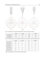
three known Zig-Bee topologies star-mesh-cluster-tree as are shown in Fig. 2., for the
application of fire detection the selection should be made between the mesh and
cluster/tree topologies since cluster/tree topologies provide higher network flexibility,
and are more power efficient using battery resources in a more optimal fashion.
Design Issues of an Operational Fire Detection System integrated with Observation Sensors
119
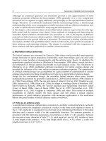
Fig. 2. Zig-Bee typical Cluster – Tree and Star network topologies.
An important performance testing parameter to be accounted for in the specified network
application is the “smooth” coexistence of WiFi/ZigBee technologies since they both operate
at the same 2.4 GHz band. For example minimization of interference risks is of paramount
importance since it has been observed in various applications that ZigBee can experience
interferences from Wi-Fi signal traffic transmission (some packet losses due to increased
WiFi power levels). Careful field testing investigation is required when employing the
wireless network to evaluate and confirm the coexistence limits of both types of RF based
technologies.
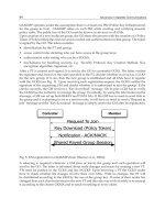
In the following Fig. 3., a Top Level - schematic geometry of the early warning architecture
is presented. The Earth Observation components are excluded for simplicity reasons.
4. Distributed event detection strategy methods
For distributed land based sensor networks related to fire detection and environmental
monitoring the event can be characterized as rather infrequent. In that setting surveillance is
highly required while reliability and timeliness in decision-making is of paramount
importance. Thus decentralized rapid detection based on fusion technology and intelligent
algorithms play a key role in the proposed model (Gustaffson, 2008). In particular
decentralized detection is an active research discipline imposing serious research problems
and design issues, [Bassevile & Nikiforov, 1993; Chamberland & Veeravali, 2006, 2007) and
(Tsitsiklis, 1993; Veeravali et al., 1993). In the proposed application low cost flame, smoke,
and temperature detectors as well as additional local environmental sensors to be employed
are subject to various power limitations. The classical concept of Decentralized Detection
introduced by [Sifakis et.al., 2009] considers a configuration where a set of distributed
sensors transmit environmental finite-valued messages to a fusion center. Then the center, is
responsible for the decision making and alerting while the classical hypothesis testing
problem is solved deciding on one of the two hypotheses, that are “a change has occurred” or
“a change has not occurred” see (Gustaffson, 2008).
zed
zed
zed
zed
zed
zed
Z
C
ZR
ZR
ZR
ZC
ZR ZR
ZR
ZC
zed
zed
zed
zed
Advances in Satellite Communications
120
Fig. 3. Block interface schematic diagram of the proposed model without the earth
observation components.
In our operational application , the decision on the type of data and alarm sequences to be
sent to the Common Operational Center is primarily realized at the Remote
Fusion/Decision Central Node (Global Decision Maker) since the Remote Data Collection
Node acts more as a concentrator of field data capable of taking some kind of partial local
decisions. It is noticed that the proposed model is decentralized in contrast to traditional
centralized configurations where each distributed sensor communicates all observation data
to the fusion center (most optimal case but with no design constraints). Moreover it is
assumed that all data collection nodes can take decisions using identical local decision rules
(Chamberland & Veeravali, 2006).
As stated in (Tsitsiklis, 1993), decentralized schemes are definitely worth considering in
contexts involving geographically distributed sensors. Also in (Chamberland & Veeravali,
2006), it is explicitly stated that the basic problem of decentralized inference is the
determination of what type of information each local sensor should transmit to the fusion
center. It is evident that efficient design of a sensor fire detection/surveillance network
depends strongly on the interplay between data compression, available spectral bandwidth,
sensor density of the network and resource allocation, observation noise, and overall
Design Issues of an Operational Fire Detection System integrated with Observation Sensors
121
optimal performance of the distributed detection process. Moreover for the decentralized
case the collected observations are required to be quantized before transmitted to the central
fusion node. These quantized measurements then belong to a finite alphabet . This procedure
as it is mentioned previously is the result of a combination of technical specifications such as
stringent communication bandwidth and high data compression. For the proposed system
each sensor transmits its own partial observation parameter such as smoke or flame, to the
Remote F/D Central Node and thus it is sub-optimal when compared to centralized
schemes were the central node has direct and full access to all observation sets. Careful and
detailed analysis is necessary for the adoption (or in house development) of intelligent
algorithms at the remote central fusion decision node.
Moreover realistic assumptions need be taken into account related to the shared medium or
the so-called common wireless spectrum. As it is pointed out, in (Imer & Basar, 2007),
several performance design challenges need to be combated when designing wireless
networks such as limited battery power, possible RF interference from other sources,
multipath effects etc. The restriction on batteries life cycle of the low RF power transmitters
or the power supply is of major importance and imposes severe limitations on the duration
of time each sensor is going to be awake/on and the number of transmission cycles is
capable of making. In our case Data Collection Nodes are autonomous and backed up by
solar panel power devices. On the other hand the different low cost environmental sensors
scattered in the remote areas impose hard power limitations. Issues such as Optimal
Measurement Scheduling with Limited Measurements need to be considered when
developing the detection algorithms both at the Fusion/Decision Central Node and at the
CoC site. In (Imer & Basar, 2007; Fellouris & Moustakides, 2008), the problem of estimating a
continuous stochastic process with limited information is considered and different criteria of
performance are analyzed for best finite measurement budget.
At this point, we mention design issues imposed by channel fading and attenuation. In a
realistic situation the quality of the communication channels between the environmental
sensors and the remote data collection and fusion/decision units is affected and degraded
by heavy environmental changes, bad weather conditions, heavy noise and disturbances,
different SNR’s, bad location dependent connections etc. Design parameters related to the
channels state and fading level need to be included during the design stage, see for further
details (Chamberland & Veeravali, 2006; Imer & Basar, 2007).
Another important twofold issue is the type of observations at the sensors and the sensor
location and density. A popular assumption is that these observations (or data) are
conditionally independent which might not hold if sensors are to be distributed with close
proximity and high density in a specified area. In that scenario sensors will transmit
observation data that are strongly correlated. Then the theory of large deviations can be
employed to evaluate the performance of the network. In our case as it is previously
mentioned the environmental sensors can be employed at least within a distance of a few
hundreds of meters apart of each other. It is not well known a priori what distance will
produce correlated or uncorrelated observations. This depends on how large the fire front
will be or of the fire progress in general. As it is explicitly stated in (Chamberland &
Veeravali, 2006) the optimal location of the sensor network before deployment requires
careful analysis and optimization and it involves a design tradeoff between the total number
of nodes and the available power resources/node of the network.
Furthermore a realistic assumption for the observation data is that they are conditionally
independent and identically distributed see (Chamberland & Veeravali, 2006; Gustaffson,
Advances in Satellite Communications
122
2008; Bassevile & Nikiforov, 1993) for further detailed exposition. Then assuming that there
are resource constraints, optimality is assured using identical sensor nodes. Optimality
under this type of condition is a positive fact since these networks are robust and easily
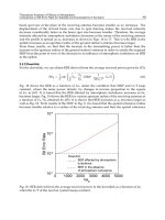
implementable. In the figure below the conceptualization of a decentralized detection model is
presented.
Fig. 5. Conceptual geometry of a decentralized detection model.
It is evident that both the number of transmitted data per node and the number of available
nodes is finite as well and the finite alphabet constraint is imposed on the output of each
sensor. Then the basic problem that needs to be solved at the Remote Fusion/Decision
Central Node is of a statistical inference type.
Another important design issue is that of decentralized sequential detection which for our
system is carried out as previously stated at the Central Node. Sequential detection and
hypothesis testing strategies involve deep mathematical results and various algorithms have
been successfully applied in modern state of the art change detection and alarm systems.
In typical change point detection problems the basic assumption is that there is a sequence
of observations of stochastic nature, whose distribution changes at some unknown time
Design Issues of an Operational Fire Detection System integrated with Observation Sensors
123
instant , for . The requirement is to quickly detect the change under false
alarm constraints. For the distributed case at hand, as it is shown in Figure 3,
measurements are realized at a set of L distributed sensors. The sensor’s outputs can be
considered in general as multi-channel and at some change-point , one channel at each
sensor changes distribution. Since sensors transmit quantized versions of their
observations to the fusion center, change detection is carried out. At this point it is useful
to mention some very basic facts and definitions related to On-line Detection. The subject
enjoys intensive ongoing research since wireless and distributed networks are in fact
gaining great popularity with an abundance of applications such as the one considered in
this work.
Let be a sequence of random variables with conditional density
and be the conditional density parameter. Before an unknown time of change the
parameter (constant). After the change time, the parameter assumes the value
and the basic detection problem is to detect this change as quickly as possible. Then a
stopping rule is needed to be defined which is often integrated in the family of change
detection algorithms. Moreover an auxiliary test statistic and a threshold is
introduced for alarm decision. The typical stopping rule has the basic form
with being a family of functions of n coordinates and
where is the so-called alarm time that the change is detected see (Bassevile & Nikiforov,
1993) for an extensive account. More formally the definition of a stopping time is the
following:
A random variable (map) is called a stopping time if
(1)
or equivalently
(2)
Notice that is a filtration, that is an increasing family of sub-sigma algebras of .
Finally five fundamental performance criteria are presented which have an intuitive reasoning
to evaluate and assess change detection algorithms:
1. Mean time between false alarms,
2. Probability of false detection,
3. Mean delay for detection,
4. Probability of non-detection,
5. Accuracy of the change time and magnitude estimates.
Usually a global performance index concerns the minimization of the delay for detection for a
fixed mean time between false alarms. For the proposed fire detection set up it is important that
careful analysis of available sequential detection algorithms is performed taking into
account the above criteria as well as the basic tradeoff between two measures: detection
delay and false alarm rate.
A series of statistical tests for continuous time processes (such as the Sequential Probability
Ratio Test - SPRT and the Cumulative Sum - CUSUM test) exist which can be combined
with state space recursive algorithms such as the Kalman filter or adaptive filtering
techniques for change detection and state estimation of the fire evolution (Gustaffson, 2008).
λ
1, 2, 3,
λ
=
λ
1
()
kkn
y
≤≤
11
(/ ,,)
kk
f
yy y
θ
−
…
θ
0
t
0
θθ
=
θ
1
θ
n
g
λ
1
inf{ : ( , , ) }
ann
tngyy
λ
=≥
1
()
nn
g
≥
a
t
:{0,1,2,,;}T Ω→ … ∞
{}{:()}, ,
n
Tn T n n
ωω
≤= ≤∈ ∀≤∞
{}{:()},
n
Tn T n n
ωω
== =∈ ∀≤∞
{: 0}
n
n ≥