Management and Services Part 7 pptx
Bạn đang xem bản rút gọn của tài liệu. Xem và tải ngay bản đầy đủ của tài liệu tại đây (581.28 KB, 10 trang )
Nonfunctional requirements validation using nash equilibria 53
100
2
n
r
s
(3)
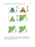
The result combined with equation (1) above implies that the network of Figure 1 has
security level equal to 2/n100=2/8100=25, since n=8. This designates that the level of
security is 25 given the functional requirements specified in configuration s. This
assessment however indicates that the initial NFR specified by the designer is not satisfied
using the prescribed functional requirements of the network as is. Hence, the network
specification needs to be revised and the security NFR revalidated, prior to implementation.
We also use the following result:
Theorem 2. [GMPPS06] Consider a network N with n nodes such that the network and security
and functional and non-functional requirements given in section 3.1 (b) are satisfied and k=n/2. Then
the network contains a stable configuration (i.e. a Nash equilibrium) s where all attackers are killed.
So, the defense ratio is
100100
a
a
r
s
(4)
The result implies that the network of Figure 2 has security level equal to 100 (recall that
k=n/2 here) given the functional requirements specified in configuration s. This assessment
indicates that the NFR specified by the designer a priori is now satisfied using the
prescribed functional requirements of the network.
4. Conclusion
Security requirements validation is traditionally performed through security-specific testing.
Ideally, validation should be performed on all possible network conditions expressed by test
scenarios. However, examining all possible scenarios [AD93, AS02] to validate security
requirement early in the design phase of a prospective network, constitutes a highly complex
and sometimes infeasible task. In this work we manage to accomplish this process in only
polynomial time. This is achieved by considering only stable configurations of the system, that
we model using Nash equilibria. This yields in a limited set of test scenarios that guarantee the
assessment of network’s security level. In this context, the method presented in this paper
constitutes a novelty in validating security NFR through game theory.
5. References
[AB04] T. Alpcan and T. Basar, ``A Game Theoretic Analysis of Intrusion Detection In
Access Control Systems,'' in Proceedings of the 43rd IEEE Conference on Decision and
Control , Vol. 2, pp. 1568-1573, 2004.
[AD93] J. S. Anderson, B. Durley, ``Using Scenarios in Deficiency-Driven Requirements
Engineering,'' in Proceedings of the Requirements Engineering (RE'99), pp. 134-141, 1993.
[ADTW03] E. Anshelevich, A. Dasgupta, É. Tardos, and T. Wexler, ‘‘Near-Optimal Network
Design with Selfish Agents,” in Proceedings of the 35th Annual ACM Symposium
on Theory of Computing (STOC), pages 511–520, 2003.
[ACY05] J. Aspnes, K. C hang, and A. Yampolskiy, `` Inoculation Strategies for Victims of
Viruses and the Sum-of-squares Partition Problem,'' in Proceedings of the 16th
Annual A CM-SIAM Symposium on Discrete Algorithms (SODA 2005) , pages 43 52.
Society for Industrial and Applied Mathematics, 2005.
[B99] D. Burke, A game theory model of Information Warfare, USAF Air Force Institute of
Technology, Air University, Master's thesis, 1999.
[Car00] J.M. Carroll, Making Use: Scenario-Based Design of Human-Computer Interaction,
MIT Press, Cambridge, MIT, 2000.
[CHK05] G. Christodoulou and E. Koutsoupias, ‘‘The Price of Anarchy of Finite Congestion
Games,” in Proceedings of the 37th Annual ACM Symposium on Theory of Computing
(STOC 2005), pages 67–73, ACM Press, 2005.
[CILN02] R. Crook, D. Ince, L. Lin and B. Nuseibeh, ``Security requirements Engineering: When
Anti-Requirements Hit the Fan,'' in Proceedings of the 10th Anniversary IEEE Joint
International Conference of Computing (STOC 2004) , pages 604—612, ACM Press, 2004.
[FPT04] A. Fabrikant, C. H. Papadimitriou, and K. Talwar, ‘‘The Complexity of Pure Nash
Equilibria,” in Proceedings of the 36th Annual ACM Symposium on Theory of
Computing (STOC 2004), pages 604–612, ACM Press, 2004.
[FAGY00] M. Franklin, Z. Galil, and M. Yung, `` Eavesdropping Games: a Graph- Theoretic
Approach to Privacy in Distributed Systems,'' Journal of the ACM , 47(2):225 243, 2000.
[GMPPS06] M. Gelastou, M. Mavronicolas, V. G. Papadopoulou, A. Philippou and P. G.
Spirakis, "The Power of the Defender", CD-ROM Proceedings of the 2nd
International Workshop on Incentive-Based Computing (IBC 2006), in conjunction
with the 26th IEEE International Conference on Distributed Computing Systems
Workshops (ICDCSW'06), pp. 37, July 2006.
[AG05] A. Gregoriades and A. Sutcliffe, ``Scenario-Based Assessment of Non-Functional
Requirements,'' Proceedings of the IEEE Transactions on Software Engineering, Vol.
31, no. 5, pp. 392-409, 2005.
[KO04] M. Kearns and L. Ortiz, ‘‘Algorithms for Interdependent Security Games,” in
Proceedings of the 16th Annual Conference on Neural Information Processing Systems
(NIPS 2004), pages 288–297, MIT Press, 2004.
[KP99] E. Koutsoupias and C. H. Papadimitriou. ``Worst-Case Equilibria,'' in Proceedings of
the 16th Annual Symposium on Theoretical Aspects of Computer Science , pp. 404 413,
Springer-Verlag, March 1999.
[L01] A. van Lamsweerde, ``Goal-Oriented Requirements Engineering: A Guided Tour,''
Proc. Fifth IEEE Int’l Symp. Requirements Eng. (RE ’01), 2001.
[L00] A. van Lamsweerde and E. Letier, ``Handling Obstacles in Goal-Oriented
Requirements Engineering,'' IEEE Trans. Software Eng., vol. 26, pp. 978-1005, 2000.
[L04] A. van Lamsweerde, ``Elaborating Security Requirements by Construction of
Intentional Anti-Models'', in Proceedings of the 26th International Conference on
Software Engineering, pp. 148 157, 2004, IEEE Press.
[LP86] L. Lovasz and M. D. Plummer, Matching Theory, North-Holland Mathematics Studies,
121, 1986.
[NR99] N. Nissan, A. Ronen, “Algorithmic Mechanism Design,” Proceedings of the 31st
Annual ACM Symposium on Theory of computing (STOC ’99), pp. 129–140, 1999.
[O94] M. J. Osborne and A. Rubinstein, A Course in Game Theory, MIT Press, 1994.
Management and Services 54
[MPPS05c] M. Mavronicolas, V. G. Papadopoulou, A. Philippou, and P. G. Spirakis, A
Graph- Theoretic Network Security Game, in Proceedings of the 1st International
Workshop on Internet and Network Economics (WINE 2005) , volume 3828 of Lecture
Notes in Computer Science , pages 969—978, Springer, 2005.
[MPPS05b] M. Mavronicolas, V. G. Papadopoulou, A. Philippou, and P. G. Spirakis, ‘‘A
Network Game with Attacker and Protector Entities”, in Proceedings of the 16th
Annual International Symposium on Algorithms and Computation (ISAAC 2005),
volume 3827 of Lecture Notes in Computer Science, pages 288–297. Springer, 2005.
[MMP08] M. Mavronicolas, B. Monien, and V. G. Papadopoulou, ‘‘How Many Attackers
Can Selfish Defenders Catch?” in CD-ROM Proceedings of the 41st Hawaii
International Conference on System Sciences, Software Technology Track, Algorithmic
Challenges in Emerging Applications of Computing Minitrack, January 2008
[MMPPS06] M. Mavronicolas, L. Michael, V. G. Papadopoulou, A. Philippou and
P. G. Spirakis, “The Price of Defense”, Proceedings of the 31st International Symposium
on Mathematical Foundations of Computer Science, pp. 717–728, Vol. 4162, Lecture
Notes in Computer Science, Springer-Verlag, August/September 2006.
[Nash50] J. F. Nash. ``Equilibrium Points in n-Person Games,'' Proceedings of the National
Academy of Sciences of the United States of America , Vol 36, pp 48-49, 1950.
[Nash51] J. F. Nash, ``Non-cooperative Games'', Annals of Mathematics , 54(2):286 295, 1951.
[C01] C. H. Papadimitriou: ``Algorithms, games, and the internet``, Proceedings of the 33rd
Annual ACM Symposium on Theory of Computing, pp. 749-753, 2001.
[P99] C. Potts, ``ScenIC: A Strategy for Inquiry-Driven Requirements Determination,'' Proc.
Int'l Symp. Requirements Eng., 1999.
[P98] C. Potts and A. Anton, ``A Representational Framework for Scenarios of System Use,''
Requirements Eng., vol. 3, pp. 219-241, 1998.
[P94] C. Potts, K. Takahashi, and A. Anton, ``Inquiry-Based Requirements Analysis,'' IEEE
Software, vol. 11, pp. 21-32, 1994.
[RT02] T. Roughgarden and É. Tardos, ‘‘How Bad is Selfish Routing?” Journal of the ACM,
49(2): 236–259, 2002.
[R05] T. Roughgarden, Selfish Routing and the Price of Anarchy. MIT Press, 2005.
[S05] I. Summerville, “Software Engineering”, Seventh Edition, Addison Wesley, 2005.
[AS02] A.G. Sutcliffe and A. Gregoriades, ``Validating Functional System Requirements
with Scenarios'', Proceedings of the First IEEE Joint International Conference of
Requirements Engineering (RE '02) , Sept. 2002.
[T04] É. Tardos, “Network games, Proceedings of the thirty-sixth Annual ACM symposium on
Theory of computing, pp. 341–342,2004
[T01] K.S. Trivedi, Probability and Statistics with Reliability, Queuing, and Computer Science
Applications, John Wiley and Sons, New York, 2001, ISBN number 0-471-33341-7.
[W08] M. Wing ''Scenario Graphs Applied to Network Security'', Information Assurance:
Survivability and Security in Networked Systems , Chapter 9, Yi Qian, James Joshi,
David Tipper, and Prashant Krishnamurthy, editors, Morgan Kaufmann
Publishers, Elsevier, Inc., 2008, pp. 247-277.
[ZJ00] H. Zhu, L., Jin, ``Scenario Analysis in an Automated Tool for Requirements
Engineering'', Journal of Requirements Engineering, 5 (1), 2-22, 2000.
Constructing geo-information sharing GRID architecture 55
Constructing geo-information sharing GRID architecture
Qiang Liu and Boyan Cheng
X
Constructing geo-information
sharing GRID architecture
Qiang Liu
1
and Boyan Cheng
1,2
1
Institute of Geo-Spatial Information Science and Technology
University of Electronic Science and Technology of China
China
2
No.95007, Guangzhou, Guangdong
China
1. Introduction
Along with the development of Internet, Geo-information Sharing and Open GIS are of
increasing importance for GIS application fields. Spatial Information Grid (SIG) is the
fundamental application of Grid technology in spatial information application service
domain. This chapter presents a pilot platform for Resource and Environment
Geo-information Sharing for Southwestern China based on Web Services, .NET, OGC, Web
GIS, SIG, and Mobile Agent is constructed. The architecture in the pilot platform consists of
3 tiers: application layer, service layer and resource layer. Via the pilot platform, distributed
heterogeneous geo-information, software and hardware resource from four provinces and
one municipality in Southwestern China is integrated.
Geospatial data is the major type of data that human beings have collected. Geospatial data
and information are significantly different from those in other disciplines. How to
effectively, wisely, and easily use the geospatial data is the key information technology issue
that we have to solve.
Along with the development of Internet, Geo-information Sharing and Open GIS are of
increasing importance. Grid technology is developed for general sharing of computational
resources and not aware of the specialty of geospatial data. Spatial Information Grid (SIG) is
the fundamental application of Grid technology in spatial information application service
domain. This paper presents a pilot platform for Resource and Environment
Geo-information Sharing Architecture for the Southwestern China based on Web Services,
Open GIS, Spatial Information Grid and OGSI.Net.
1.1. Open Geographical Information Systems
In (Panagiotis A. Vretanos. 2005), Open GIS Consortium (OGC) thinks that Interoperability
is the “capability to communicate, execute programs, or transfer data among various
functional units in a manner that requires the user to have little or no knowledge of the
unique characteristics of those units.” There are many methods of information
4
Management and Services 56
communications, such as CGI (Common Gateway Interface), Server API (Application
Programming Interface), Plug-in GIS, Java Applet, ActiveX and COM (Component Object
Model).
The distributed geographic information sharing technology includes three models, which
are Microsoft’s DCOM (Distributed Component Object Model)/ActiveX, Sun’s Java/RMI
and OMG’s (object management group) CORBA (common object request broker
architecture). The ActiveX/DCOM model only runs on the Microsoft Windows platform,
and Java/RMI technology localizes on the Java language. In despite of the independency of
languages and Operate Systems, CORBA adapts to construct the distributed systems of
compact coupling.
In a sense, Web Services extend the distributed Objects/Component technology. By contrast
with the former Interoperable methods, Web Services accomplish the accesses to objects in
the loose coupling circumstances. Web components can implement and publish in any
computer which provides corresponding functions and services, and also integrate the
heterogeneous applications. Therefore, the technology of Web Services adapts to share the
Geo-information of heterogeneous GISs.
Fig. 1. Three roles in Web Service
Web Services, which are the product of the Internet, publish the standard interfaces of
functions or services. The protocols such as Simple Object Access Protocol (SOAP), Web
Services Description Language (WSDL) and universal Description, Discovery and
Identification (UDDI) provide the architecture for simple, yet effective GIS interoperability
independent of concrete platforms and softwares. UDDI’s aim is to develop a standard for
an online registry, and to enable the publishing and dynamic discovery of Web services
offered by businesses. Web Service Architecture includes three roles (as illustrated in Fig.
1.): Service Provider, Service Registry (or Service Broker), and Service Requester. Service
Provider is the provider of the web service. The provider implements the service, and makes
it available on the Internet. Service Requester is any consumer of the web service. The
requestor utilizes an existing web service by opening a network connection and sending an
XML request. Service Registry is a logically centralized directory of services. The registry
provides a central place where developers can publish new services or find existing ones. It
therefore serves as a centralized clearinghouse for companies and their services. The roles
communicate through three behaviors: Publish, Find, and Bind.
Provider entity may descript a service with WDSL, and then may register the service in
Registration Center (such as OGC Service Registry). Request may find the description of a
service in Registration Center, and then bind with the Provider that publishes the service.
Request may communicate with Provider each other, and may invoke the service.
Fig. 2. Architecture of GIS based on Web Service
In (Joshua Lieberman. 2003), the OpenGIS Services Framework (as illustrated in Fig. 2.)
provides the common set of interfaces that spans these functional parts of the enterprise and
provides enterprise-wide interoperability.
The elements of the architecture are listed as follows:
Client Services - the client-side components of client applications that interact with users,
and on the server-side interact with Server-side Client Applications, Application Servers
and Data Servers.
Registry Services – provides a common mechanism to classify, register, describe, search,
maintain and access information about network resources (data and services). Registry
Services include Web Registry Service (WRS).
Processing-Workflow Services – the foundational application-building-block services that
operate on geospatial data and metadata, providing value-add service.
Processing-Workflow Services include Sensor Planning Service (SPS) and Web Notification
Service (WNS).
Portrayal Services – Portrayal Services provide specialized capabilities supporting
visualization of geospatial information. Portrayal Services are components that, given one or
more inputs, produce rendered outputs such as cartographically portrayed maps,
perspective views of terrain, annotated images, views of dynamically changing features in
space and time, etc.). Portrayal Services include Web Map Service (WMS), Coverage
Portrayal Service (CPS) and Style Management Service (SMS).
Data Services – The foundational service building blocks that serve data, specifically
geospatial data. Data Services include Web Object Service (WOS), Web Feature Service
Constructing geo-information sharing GRID architecture 57
communications, such as CGI (Common Gateway Interface), Server API (Application
Programming Interface), Plug-in GIS, Java Applet, ActiveX and COM (Component Object
Model).
The distributed geographic information sharing technology includes three models, which
are Microsoft’s DCOM (Distributed Component Object Model)/ActiveX, Sun’s Java/RMI
and OMG’s (object management group) CORBA (common object request broker
architecture). The ActiveX/DCOM model only runs on the Microsoft Windows platform,
and Java/RMI technology localizes on the Java language. In despite of the independency of
languages and Operate Systems, CORBA adapts to construct the distributed systems of
compact coupling.
In a sense, Web Services extend the distributed Objects/Component technology. By contrast
with the former Interoperable methods, Web Services accomplish the accesses to objects in
the loose coupling circumstances. Web components can implement and publish in any
computer which provides corresponding functions and services, and also integrate the
heterogeneous applications. Therefore, the technology of Web Services adapts to share the
Geo-information of heterogeneous GISs.
Fig. 1. Three roles in Web Service
Web Services, which are the product of the Internet, publish the standard interfaces of
functions or services. The protocols such as Simple Object Access Protocol (SOAP), Web
Services Description Language (WSDL) and universal Description, Discovery and
Identification (UDDI) provide the architecture for simple, yet effective GIS interoperability
independent of concrete platforms and softwares. UDDI’s aim is to develop a standard for
an online registry, and to enable the publishing and dynamic discovery of Web services
offered by businesses. Web Service Architecture includes three roles (as illustrated in Fig.
1.): Service Provider, Service Registry (or Service Broker), and Service Requester. Service
Provider is the provider of the web service. The provider implements the service, and makes
it available on the Internet. Service Requester is any consumer of the web service. The
requestor utilizes an existing web service by opening a network connection and sending an
XML request. Service Registry is a logically centralized directory of services. The registry
provides a central place where developers can publish new services or find existing ones. It
therefore serves as a centralized clearinghouse for companies and their services. The roles
communicate through three behaviors: Publish, Find, and Bind.
Provider entity may descript a service with WDSL, and then may register the service in
Registration Center (such as OGC Service Registry). Request may find the description of a
service in Registration Center, and then bind with the Provider that publishes the service.
Request may communicate with Provider each other, and may invoke the service.
Fig. 2. Architecture of GIS based on Web Service
In (Joshua Lieberman. 2003), the OpenGIS Services Framework (as illustrated in Fig. 2.)
provides the common set of interfaces that spans these functional parts of the enterprise and
provides enterprise-wide interoperability.
The elements of the architecture are listed as follows:
Client Services - the client-side components of client applications that interact with users,
and on the server-side interact with Server-side Client Applications, Application Servers
and Data Servers.
Registry Services – provides a common mechanism to classify, register, describe, search,
maintain and access information about network resources (data and services). Registry
Services include Web Registry Service (WRS).
Processing-Workflow Services – the foundational application-building-block services that
operate on geospatial data and metadata, providing value-add service.
Processing-Workflow Services include Sensor Planning Service (SPS) and Web Notification
Service (WNS).
Portrayal Services – Portrayal Services provide specialized capabilities supporting
visualization of geospatial information. Portrayal Services are components that, given one or
more inputs, produce rendered outputs such as cartographically portrayed maps,
perspective views of terrain, annotated images, views of dynamically changing features in
space and time, etc.). Portrayal Services include Web Map Service (WMS), Coverage
Portrayal Service (CPS) and Style Management Service (SMS).
Data Services – The foundational service building blocks that serve data, specifically
geospatial data. Data Services include Web Object Service (WOS), Web Feature Service
Management and Services 58
(WFS), Sensor Collection Service (SCS), Image Archive Service (IAS) and Web Coverage
Service (WCS).
The OGC (Open GIS Consortium) constitutes three principal interoperable specifications to
access Web Services, which are Web Map Server (WMS) as well as the Web Coverage Server
(WCS) and the Web Feature Server (WFS). A Web Map Service produces maps of
geo-referenced data. This WMS specification (Praveen Ummadi) defines three WMS
operations: GetCapabilities (required) returns service-level metadata, which is a
machine-readable (and human-readable) description of the WMS service’s information
content and acceptable request parameters; GetMap (required) returns a map image whose
geospatial and dimensional parameters are well-defined; GetFeatureInfo (optional) returns
information about particular features shown on a map. A “map” defined as a visual
representation of geo-data is not the data itself. The WFS operations support INSERT,
UPDATE, DELETE, QUERY and DISCOVERY operations on geographic features using
HTTP as the distributed computing platform. In (Boucelma et al, 2002), this WFS
specification (Boucelma et al, 2002) defines two kinds of WFS operations: Basic WFS and
Transaction WFS. A basic WFS would implement three WFS operations: GetCapabilities
(required) describe the capabilities of a web feature service such as which feature types it
can service and what operation are supported on each feature type; DescribeFeatureType
(required), upon request, describes the structure of any feature type a web feature service
can service; GetFeature (required) services a request to retrieve feature instances, when the
client specifies which feature properties to fetch and constrains the query spatially and
non-spatially. The Basic WFS is considered a READ-ONLY web feature service. A
transaction WFS supports all the operations of a Basic WFS and in addition it implement the
Transaction operation. A transaction request is composed of operations that modify
features; that is CREATE, UPDATE, and DELETE operations on geographic features.
Optionally, a transaction WFS could implement the LockFeature operation that process a
lock request on one or more instances of a feature type for the duration of a transaction. This
ensures that serial transactions are supported.
At present, many GIS applications are independent of each other, and are not interoperable.
ArcIMS, ESRI’s Web mapping server technology has its own XML protocol, ArcXML
utilized to communicate between ArcIMS client and ArcIMS server. ESRI’s MapObjectsIMS,
which provides clients with images of geo-data, is a tool to develop Web GIS. AutoDesk’s
Mapguide deals with requests from Mapguide Viewer, and returns the geo-data.
Intergraph’s GeoMedia transmits ActiveCGM to clients and makes vector maps. These GIS
softwares receive respective requests from their own clients. ArcIMS and MapObjectsIMS
servers return images of geo-data, Mapguide ans GeoMedia servers provide vector maps. It
is difficult to interoperate the applications and the geo-data of these GISs.
1.2. Spatial Information Grid
In (S. Tuecke et al., 2003), (Ian Foster & Carl Kesselman, 1999) and (Ian Foster et al, 2002), the
term “Grid” was coined in the mid-1990s to denote a proposed distributed computing
infrastructure for advanced science and engineering. “Grid” computing has emerged as an
important new field, distinguished from conventional distributed computing by its focus on
large-scale resource sharing, innovative applications. The concept of the “SIG” (spatial
information grid) which was put forward based on the grid computing, is the fundamental
plan and useful tool to construct the Geo-information sharing. SIG is an intelligent
information platform which is built based on the current spatial information infrastructure
and spatial information network protocol specification and from which the user can obtain
the common spatial information services conveniently. The procession of the spatial
information in this platform is distributing collaborated and intelligent in this platform, and
user can visit all spatial information via the common protocol and do not need to know the
information he needed from million website from internet.
In (I. Foster et al, 2005), Global Grid Forum think that grid systems and applications aim to
integrate, virtualize, and manage resources and services within distributed, heterogeneous,
dynamic “virtual organizations”. The realization of this goal requires the disintegration of
the numerous barriers that normally separate different computing systems within and
across organizations, so that computers, application services, data, and other resources can
be accessed as and when required, regardless of physical location. The Open Grid Services
Architecture (OGSA) is a service-oriented architecture. It is intended to facilitate the
seamless use and management of distributed, heterogeneous resources. In this architecture,
the terms “distributed,” “heterogeneous” and “resources” are used in their broad sense. For
example: “distributed” could refer to a spectrum from geographically-contiguous resources
linked to each other by some connection fabric to global, multi-domain, loosely- and
intermittently-connected resources. “Resources” refers to any artifact, entity or knowledge
required to complete an operation in or on the system.
Building on both Grid and Web Services technologies, the Open Grid Services Infrastructure
(OGSI) defines mechanisms for creating, managing, and exchanging information among
entities called Grid services. In a word, a Grid Service is a Web Service that conforms to a set
of conventions (interfaces and behaviors) that define how a client interacts with a Grid
Service.
Web Services address the discovery and invocation of persistent services, and offer a
powerful application-to-application integration framework. Web Services miss state
management, global service naming, reference resolution and common behaviors and
semantics defined for services by some interface description language. Web Services are
stateless. In contrast, Grid Services are stateful Web Services. Grid Services are the glue that
transforms a collection of distributed, independent resources into a coherent computation,
storage, and collaboration fabric. They provide uniform mechanisms for user authentication
and authorization, accounting, resource access, data transfer, system monitoring, and
resource management. Grid Services make it possible for users, applications, and tools to
discover and use disparate resources in coordinated ways.
In (Glenn Wasson et al, 2004), the basic design of OGSI.NET is to have a container entity that
“holds” all the service instances running on a host. As illustrated in Fig. 3, the container
process consists of a collection of Application Domains (or AppDomains), Microsoft’s
mechanism for intra-process memory protection. Each service instance executes in its own
AppDomain and there is one additional domain for the container’s logic (some dispatching
and message processing functionality).
A client makes a request on the OGSI.NET architecture by sending a message to the IIS web
server. In order to support arbitrary names for grid services, OGSI.NET uses an ISAPI filter
to intercept requests at an early stage in the IIS request chain. This filter re-writes the request
so that IIS will dispatch it to OGSI.NET’s ASP.NET HttpHandler. This HttpHandler
dispatches the request to the OGSI.NET container. The container process has a thread pool
and each IIS request causes one of the container process’ threads to execute the dispatcher.
Constructing geo-information sharing GRID architecture 59
(WFS), Sensor Collection Service (SCS), Image Archive Service (IAS) and Web Coverage
Service (WCS).
The OGC (Open GIS Consortium) constitutes three principal interoperable specifications to
access Web Services, which are Web Map Server (WMS) as well as the Web Coverage Server
(WCS) and the Web Feature Server (WFS). A Web Map Service produces maps of
geo-referenced data. This WMS specification (Praveen Ummadi) defines three WMS
operations: GetCapabilities (required) returns service-level metadata, which is a
machine-readable (and human-readable) description of the WMS service’s information
content and acceptable request parameters; GetMap (required) returns a map image whose
geospatial and dimensional parameters are well-defined; GetFeatureInfo (optional) returns
information about particular features shown on a map. A “map” defined as a visual
representation of geo-data is not the data itself. The WFS operations support INSERT,
UPDATE, DELETE, QUERY and DISCOVERY operations on geographic features using
HTTP as the distributed computing platform. In (Boucelma et al, 2002), this WFS
specification (Boucelma et al, 2002) defines two kinds of WFS operations: Basic WFS and
Transaction WFS. A basic WFS would implement three WFS operations: GetCapabilities
(required) describe the capabilities of a web feature service such as which feature types it
can service and what operation are supported on each feature type; DescribeFeatureType
(required), upon request, describes the structure of any feature type a web feature service
can service; GetFeature (required) services a request to retrieve feature instances, when the
client specifies which feature properties to fetch and constrains the query spatially and
non-spatially. The Basic WFS is considered a READ-ONLY web feature service. A
transaction WFS supports all the operations of a Basic WFS and in addition it implement the
Transaction operation. A transaction request is composed of operations that modify
features; that is CREATE, UPDATE, and DELETE operations on geographic features.
Optionally, a transaction WFS could implement the LockFeature operation that process a
lock request on one or more instances of a feature type for the duration of a transaction. This
ensures that serial transactions are supported.
At present, many GIS applications are independent of each other, and are not interoperable.
ArcIMS, ESRI’s Web mapping server technology has its own XML protocol, ArcXML
utilized to communicate between ArcIMS client and ArcIMS server. ESRI’s MapObjectsIMS,
which provides clients with images of geo-data, is a tool to develop Web GIS. AutoDesk’s
Mapguide deals with requests from Mapguide Viewer, and returns the geo-data.
Intergraph’s GeoMedia transmits ActiveCGM to clients and makes vector maps. These GIS
softwares receive respective requests from their own clients. ArcIMS and MapObjectsIMS
servers return images of geo-data, Mapguide ans GeoMedia servers provide vector maps. It
is difficult to interoperate the applications and the geo-data of these GISs.
1.2. Spatial Information Grid
In (S. Tuecke et al., 2003), (Ian Foster & Carl Kesselman, 1999) and (Ian Foster et al, 2002), the
term “Grid” was coined in the mid-1990s to denote a proposed distributed computing
infrastructure for advanced science and engineering. “Grid” computing has emerged as an
important new field, distinguished from conventional distributed computing by its focus on
large-scale resource sharing, innovative applications. The concept of the “SIG” (spatial
information grid) which was put forward based on the grid computing, is the fundamental
plan and useful tool to construct the Geo-information sharing. SIG is an intelligent
information platform which is built based on the current spatial information infrastructure
and spatial information network protocol specification and from which the user can obtain
the common spatial information services conveniently. The procession of the spatial
information in this platform is distributing collaborated and intelligent in this platform, and
user can visit all spatial information via the common protocol and do not need to know the
information he needed from million website from internet.
In (I. Foster et al, 2005), Global Grid Forum think that grid systems and applications aim to
integrate, virtualize, and manage resources and services within distributed, heterogeneous,
dynamic “virtual organizations”. The realization of this goal requires the disintegration of
the numerous barriers that normally separate different computing systems within and
across organizations, so that computers, application services, data, and other resources can
be accessed as and when required, regardless of physical location. The Open Grid Services
Architecture (OGSA) is a service-oriented architecture. It is intended to facilitate the
seamless use and management of distributed, heterogeneous resources. In this architecture,
the terms “distributed,” “heterogeneous” and “resources” are used in their broad sense. For
example: “distributed” could refer to a spectrum from geographically-contiguous resources
linked to each other by some connection fabric to global, multi-domain, loosely- and
intermittently-connected resources. “Resources” refers to any artifact, entity or knowledge
required to complete an operation in or on the system.
Building on both Grid and Web Services technologies, the Open Grid Services Infrastructure
(OGSI) defines mechanisms for creating, managing, and exchanging information among
entities called Grid services. In a word, a Grid Service is a Web Service that conforms to a set
of conventions (interfaces and behaviors) that define how a client interacts with a Grid
Service.
Web Services address the discovery and invocation of persistent services, and offer a
powerful application-to-application integration framework. Web Services miss state
management, global service naming, reference resolution and common behaviors and
semantics defined for services by some interface description language. Web Services are
stateless. In contrast, Grid Services are stateful Web Services. Grid Services are the glue that
transforms a collection of distributed, independent resources into a coherent computation,
storage, and collaboration fabric. They provide uniform mechanisms for user authentication
and authorization, accounting, resource access, data transfer, system monitoring, and
resource management. Grid Services make it possible for users, applications, and tools to
discover and use disparate resources in coordinated ways.
In (Glenn Wasson et al, 2004), the basic design of OGSI.NET is to have a container entity that
“holds” all the service instances running on a host. As illustrated in Fig. 3, the container
process consists of a collection of Application Domains (or AppDomains), Microsoft’s
mechanism for intra-process memory protection. Each service instance executes in its own
AppDomain and there is one additional domain for the container’s logic (some dispatching
and message processing functionality).
A client makes a request on the OGSI.NET architecture by sending a message to the IIS web
server. In order to support arbitrary names for grid services, OGSI.NET uses an ISAPI filter
to intercept requests at an early stage in the IIS request chain. This filter re-writes the request
so that IIS will dispatch it to OGSI.NET’s ASP.NET HttpHandler. This HttpHandler
dispatches the request to the OGSI.NET container. The container process has a thread pool
and each IIS request causes one of the container process’ threads to execute the dispatcher.
Management and Services 60
The dispatcher determines which service instance should get the request and transfers
execution of that thread to an object in the appropriate AppDomain.
Fig. 3. OGSI Container on the .Net Platform
1.3. Mobile Agent Technology
In (D. Chess et al, 1994), mobile agent is considered as an enabling technology for automated,
flexible and customized service provision in a highly distributed way as network nodes
become active and take part in the computation of applications and provision of customized
services. Besides the clear separation among the key functionality and the aspects of
deployment on the functional side, Mobile Agent can offer potential technical advantages.
Among them are reduced communication cost, reduced bandwidth usage, the possibility of
using remote interfaces and the support for off-line computation. Mobile agents enable both
temporal and spatial distribution of the service logic, which makes another technical
advantage, namely scalability, while at the same time bottlenecks of centralized approaches
such as reduced network availability and malfunctioning are avoided (A. Puliafito et al,
2001). With the capabilities mentioned above, Mobile agents can provide a suitable
framework for spatial data resource and service discovery in grid platforms, and can
support optimal access and interaction through heterogeneous terminals, differing in terms
of memory capacity, computational resources, display characteristics, allowed connection
mode, etc (A. L. Corte et al, 1999).
In (Jian Ma et al, 2006), the architecture with the convergency of Mobile Agent and Spatial
Data Grid is constructed. A middleware layer allowing users to access distributed resources
in a transparent, secure and effective way is proposed. The Grid middleware is integrated
with functions to make data mining and data transferring easier. And the mobile agent that
manages the user and the issues related with the heterogeneity of the devices is applied.
The agents provided by the system are classed into two types: user agent, carrying users’
requests for spatial data; information agent, representing information of distributed spatial
data resources and providing spatial data services for other agents. Otherwise, Agency
Agent is proposed to settle distributed transparency of system. Agents could communicate
with Agency Agent and obtain other agents’ information (attribute, location, and resources,
etc), and then move to the resource node located and complete corresponding work.
The Mobile Agent system consists of a set of agent subsystems and the agency agent system
whose task is to manage the information of all agent subsystems. The agent subsystem
which includes User Agent, Native Query Agent and Collaboration Query Agent is
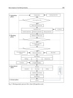
interactive and distributed. The system architecture is shown in Fig.4.
Fig. 4. the Geo-information sharing Grid architecture based on Mobile Agent
Agency Agent (AA), playing the most important role in the whole system, is the key
technology to solve the requirement of distributed transparency. The task of Agency Agent
is to collect, manage, query all agents’ information, and at one time act as a dependable
secure authentication center to ensure communication among those agent subsystems. The
information Agency Agent needs is provided by information base of agents.
User Agent (UA) has the main task of providing the user with the services he wishes. User
Agent which has friendly user interface can accept spatial data requests from users and
return them results. User Agent is able to transform users’ requests into commands which
could be identified by other agents, and search correlative information agent automatically.
The process between putting forward requests and returning results is transparent for users.
Native Query Agent (NQA) accepts request from User Agent, and communicates with
native spatial data services which are built up in the grid environment to obtain information
needed. Native Query Agent is founded by User Agent and runs in background. Native
Query Agent is also transparent for users.
Collaboration Query Agent is a mobile agent. It accepts collaboration information query
requests from User Agent, gets the address of target agent subsystem from Agency Agent,
then moves to target host computer and completes the information query task.
The whole process for information query is described as follows:
Constructing geo-information sharing GRID architecture 61
The dispatcher determines which service instance should get the request and transfers
execution of that thread to an object in the appropriate AppDomain.
Fig. 3. OGSI Container on the .Net Platform
1.3. Mobile Agent Technology
In (D. Chess et al, 1994), mobile agent is considered as an enabling technology for automated,
flexible and customized service provision in a highly distributed way as network nodes
become active and take part in the computation of applications and provision of customized
services. Besides the clear separation among the key functionality and the aspects of
deployment on the functional side, Mobile Agent can offer potential technical advantages.
Among them are reduced communication cost, reduced bandwidth usage, the possibility of
using remote interfaces and the support for off-line computation. Mobile agents enable both
temporal and spatial distribution of the service logic, which makes another technical
advantage, namely scalability, while at the same time bottlenecks of centralized approaches
such as reduced network availability and malfunctioning are avoided (A. Puliafito et al,
2001). With the capabilities mentioned above, Mobile agents can provide a suitable
framework for spatial data resource and service discovery in grid platforms, and can
support optimal access and interaction through heterogeneous terminals, differing in terms
of memory capacity, computational resources, display characteristics, allowed connection
mode, etc (A. L. Corte et al, 1999).
In (Jian Ma et al, 2006), the architecture with the convergency of Mobile Agent and Spatial
Data Grid is constructed. A middleware layer allowing users to access distributed resources
in a transparent, secure and effective way is proposed. The Grid middleware is integrated
with functions to make data mining and data transferring easier. And the mobile agent that
manages the user and the issues related with the heterogeneity of the devices is applied.
The agents provided by the system are classed into two types: user agent, carrying users’
requests for spatial data; information agent, representing information of distributed spatial
data resources and providing spatial data services for other agents. Otherwise, Agency
Agent is proposed to settle distributed transparency of system. Agents could communicate
with Agency Agent and obtain other agents’ information (attribute, location, and resources,
etc), and then move to the resource node located and complete corresponding work.
The Mobile Agent system consists of a set of agent subsystems and the agency agent system
whose task is to manage the information of all agent subsystems. The agent subsystem
which includes User Agent, Native Query Agent and Collaboration Query Agent is
interactive and distributed. The system architecture is shown in Fig.4.
Fig. 4. the Geo-information sharing Grid architecture based on Mobile Agent
Agency Agent (AA), playing the most important role in the whole system, is the key
technology to solve the requirement of distributed transparency. The task of Agency Agent
is to collect, manage, query all agents’ information, and at one time act as a dependable
secure authentication center to ensure communication among those agent subsystems. The
information Agency Agent needs is provided by information base of agents.
User Agent (UA) has the main task of providing the user with the services he wishes. User
Agent which has friendly user interface can accept spatial data requests from users and
return them results. User Agent is able to transform users’ requests into commands which
could be identified by other agents, and search correlative information agent automatically.
The process between putting forward requests and returning results is transparent for users.
Native Query Agent (NQA) accepts request from User Agent, and communicates with
native spatial data services which are built up in the grid environment to obtain information
needed. Native Query Agent is founded by User Agent and runs in background. Native
Query Agent is also transparent for users.
Collaboration Query Agent is a mobile agent. It accepts collaboration information query
requests from User Agent, gets the address of target agent subsystem from Agency Agent,
then moves to target host computer and completes the information query task.
The whole process for information query is described as follows:
Management and Services 62
1) A request for spatial data is sent to User Agent via web explorer.
2) A request for native information query is sent to Native Query Agent by User Agent.
3) When the native information query is accomplished, the collaboration information query
is provided. First, Collaboration Query Agent asks Agency Agent for other agent
subsystems’ profile information.
4) When gets other agent subsystems’ context information, Collaboration Query Agent
dispatches a mobile agent which carries corresponding request to the spatial information
node located, then the mobile agent asks for native information query in the target agent
subsystem’s context and returns the result.
Java is adopted in the whole system’s implementation to meet platform-independence. Grid
environment is built up with Globus Toolkit 4, which is based on Java. Agents’ mobility and
interoperability is met by Aglets which is based on Java. Dynamic web page and function of
User Agent is implemented by Servlet which is based on Java. The communication among
agents is actualized by Aglets’ message system which is also based on Java.
2. Framework of the resource and environment Geo-information
sharing architecture based on Web Services
Fig. 5. The resource and environment Geo-information sharing architecture for the
Southwestern China
Web service is a stateless service. The Resource and Environment Geo-information Sharing
Architecture for the Southwestern China presented in (LIU Qiang & CHENG Boyan, 2006) is
based on Web service. It integrates resource and environment geo-information from four
provinces and one municipality in the Southwestern China. The framework is illustrated in
Fig. 5.
This architecture in the pilot platform consists of 3 tiers (as illustrated in Fig. 4): Client side,
Catalog side and Server side. Catalog side is a multi-level tree structure. The top node is a
UDDI Catalog Server of Southwestern China, which owns several children nodes, Guizhou
Catalog Server, Sichuan Catalog Server, Yunnan Catalog Server and Chongqing Catalog
Server. These children nodes also own several their own children nodes, respectively. For
example, Sichuan Catalog Server’s children nodes are Chengdu Catalog Server, Mianyang
Catalog Server, and Zigong Catalog Server, etc. All Services in Southwestern China are
separated into several cases corresponding to UDDI Catalog Servers. For instance,
Provincial Services such as Sichuan Basemap Service, Sichuan Forest Resource Service,
Sichuan Land Resource Service, and Sichuan Water Resource Service as well as the children
Catalog Servers are registered into Sichuan Catalog Server. Municipal Services such as
Chengdu Basemap Service, Chengdu Planning Service, Chengdu Cadastral Service and
Chengdu Water Supply Pipeline Service as well as the children Catalog Servers are
registered into Chengdu Catalog Server. Thus, users can access all services via the UDDI
catalog servers tree conveniently.
2.1. System Structure Platform Architecture
The stateless architecture in the pilot platform consists of 3 tiers (as illustrated in Fig. 6):
client side, catalog side and server side.
The server side as service provider publishes and registers services to the catalog side. It
includes multiple web sites which provide services of geo-data (base map database, forest,
land-use, mineral, disaster and water resources, etc.) and mapping functions (Qiang Liu et al,
2005).
Fig. 6. The 3tiers architecture in the pilot platform
As a service requester, the client side makes the OGC WMS-compliant command to inquire
geo-data and services. It finds the service description in the catalog side, then binds the
service provider and invokes the service. At last, the client side displays the result and the
image. The client side communicates with the server side via SOAP.