Intelligent Vehicle Technology And Trends Episode 1 Part 11 pot
Bạn đang xem bản rút gọn của tài liệu. Xem và tải ngay bản đầy đủ của tài liệu tại đây (156.36 KB, 20 trang )
Applications Based on Roadside-to-Vehicle Communications The applications shown
in Table 9.2 can be implemented based on a fairly consistent set of communications
parameters:
•
One-way communication;
•
Point-to-multipoint communication;
•
Transmission mode: periodic;
•
Minimum frequency (update rate): ~ 10 Hz;
•
Allowable latency ~ 100 msec (consistent with typical automotive sensor
update rates);
•
Maximum required range of communication: 250–300m.
For intersection situations, the infrastructure system obtains information about
approaching vehicles using sensors and/or DSRC, including parameters such as their
position, velocity, acceleration, and turning status. Relevant data can then be transmit
-
ted to the host vehicle. Road surface and weather conditions can be transmitted to
assist the vehicle system in optimally estimating braking distance. In these scenarios,
either the roadside system or the vehicle system can estimate collision risk and takes
appropriate action.
Applications Based on Vehicle-to-Vehicle Communications The V-V applications shown
in Table 9.3 can be implemented based on the same communications parameters as
182 Cooperative Vehicle-Highway Systems (CVHS)
Table 9.2 Selected DSRC Applications Based on Roadside-to-Vehicle Communications
Application Function Data communicated
Traffic signal
violation warning
Warns the driver to stop if a traffic signal is in
the stop phase and the system predicts that
the driver will be in violation, based on vehi
-
cle speed and braking status
Traffic signal status and timing
Traffic signal stopping location
Traffic signal directionality
Road surface condition
Weather condition
Stop sign violation
warning
Warns the driver if the distance to the stop
sign and the speed of the vehicle indicate that
a high level of braking is required to properly
stop
Stopping location
Directionality
Road surface condition
Weather conditions
Stop sign
movement
assistance
Provides a warning to a vehicle entering an
intersection after having stopped at a stop
sign, to avoid a collision with traffic
approaching the intersection
Vehicle position, velocity,
and heading; Warning
Intersection
collision warning
Warns drivers when a collision at an
intersection is probable
Traffic signal status, timing,
and directionality;
Road shape
Intersection layout;
Vehicle position, velocity,
and heading
Curve speed
warning
Aids the driver in negotiating curves at appro
-
priate speeds, by using information communi
-
cated from roadside beacons located ahead of
approaching curves
Curve location
Curve speed limits
Curvature
Super-elevation
Road surface condition
those above with the exception of range, which varies according to the application.
Generally, the communications information is meant to augment, not replace,
onboard vehicle sensors.
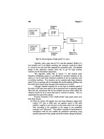
Precrash Sensing For illustrative purposes, communications for precrash sensing
is examined in a bit more detail here. The required communication range is
approximately 25m, with messaging in a broadcast mode for more basic systems.
However, a cooperative precrash sensing system can also be conceptualized
in which two-way communications occurs once the radar sensor predicts the
eventuality of a collision, in order to exchange data such as vehicle type. A generic
block diagram for such a system, developed within the VSCC project, is shown in
Figure 9.1.
In Figure 9.1, in-vehicle sensors refers to information that is available on the
vehicle data-bus, such as speed, yaw rate, longitudinal acceleration, lateral accelera
-
tion, steering wheel angle, air bag crash sensors, and brakes and throttle status data.
Static vehicle data refers to parameters such as vehicle ID, class, size, mass, and
DSRC antenna location. The differential GPS (DGPS) unit provides vehicle posi
-
tion, heading, and time stamp. The DSRC onboard unit (OBU) provides messaging
at 10 Hz in broadcast mode and 50 Hz for two-way communications. The radar
unit measures target range, range rate and azimuth angle. The precrash processor
consists of a DSRC message processing unit and a radar processing unit to conduct
the threat evaluation and confirmation based on the radar data, the host vehicle
9.1 Wireless Communications as a Foundation for Cooperative Systems 183
Table 9.3 Selected DSRC Applications Based on Vehicle-to-Vehicle Communications
Application Function
Data
communicated Range (m)
Cooperative forward
collision warning
Aids the driver in mitigating or avoiding a forward
collision; data received from the forward vehicle is
used along with host vehicle information as to its
own position, dynamics, and roadway information
to estimate collision risk
– Position
– velocity
– heading
– yaw rate
– acceleration
150
Emergency electronic
brake light
When a forward vehicle brakes strongly, a message
is sent to other vehicles following behind to provide
advance notification even if the radar sensors or the
driver’s visibility is limited by weather or other
vehicles
– Position
– heading
– velocity
– deceleration
300
Road condition
warning
Marginal road conditions are detected using onboard
systems and sensors and a road condition warning is
transmitted to other vehicles via broadcast. This
information enables the host vehicle to generate
speed recommendations for the driver
– Position
– heading
– road condition
– parameters
~400
Lane change
warning
Warns the driver if an intended lane change may
cause a crash with a nearby vehicle by processing
information sent from surrounding vehicles and
estimating crash risk when the driver signals a
lane change intention
– Position
– heading
– velocity
– acceleration
– turn signal
– status
~150
data and the DSRC message data. Commands for actuation of airbags or braking
are generated by the collision countermeasures module.
Japanese DSRC Development and Testing [5] AHSRA in Japan has led the way in
road-vehicle communications systems, performing extensive work beginning zin the
mid 1990s. The country’s focus has been to ensure that vehicles are provided with
information on obstacles or other road hazards that are detected by roadside
sensors; the subsequent actions (warning or automatic braking) are determined by
the onboard vehicle systems.
Japan is transitioning its electronic toll collection to DSRC because of the high
reliability, large data transfer, and rapid messaging (to accommodate vehicles at
highway speeds) that the protocol supports. A spot communications approach was
selected for practical application over a continuous communications approach.
AHSRA analyses have shown that providing information via spot communication
(using a 30 m zone) offers nearly 50% of that offered by continuous communica
-
tion, which is seen as adequate. As of late 2003, 1.6 million onboard units were in
circulation. Compatible roadside readers were expected to be installed at virtually
all tollgates in Japan by the end of that year.
184 Cooperative Vehicle-Highway Systems (CVHS)
radar -based
threat
assessment +
DSRC -based
confirmation
In-vehicle
sensors
Radar
DGPS
Message
processor for
standard
broadcast
message and
two-way
message
Radar-based
threat
assessment +
DSRC-based
confirmation
DSRC
OBU
Collision mitigation
countermeasure
Objects
(other vehicles
clutter,etc.)
Radar
antenna
DSRC
antenna
Static
vehicle
data:
class, size,
antenna
location,
mass, etc.
Threat
confirmation
message information
Request two-way
communication
from potential
threat
Precrash
processor
Figure 9.1 Block Diagram for a conceptual cooperative collision mitigation system. (Source: VSCC
Task3 Final Report, U.S. Department of Transportation and Crash Avoidance Metrics Partnership
(CAMP), December, 2004.)
The AHSRA approach employs a two-beacon system for information points.
The “starting beacon” orients the vehicle with reference points and informs it that
information is available. The “information beacon” provides the relevant informa
-
tion. In this way, the vehicle can judge the content and timing of services and pro
-
vide information to the driver as appropriate. The combination of information from
the two beacon types allows the vehicle to know the direction in which services are
provided and judge whether to accept the services.
Data reliability has been a key focus. AHSRA established the concept of the
safety integrity level (SIL), which encompasses both the accuracy of the information
provided and the communications integrity. AHSRA assigned a share of 99.1% of
the SIL to the road-to-vehicle communications link, given the many factors that can
affect signal transmission—such as environmental conditions, radio wave leakage,
code errors, shadowing, radio interference, crosstalk, equipment malfunction, and
power failure. Extensive testing has been conducted, in particular for the character
-
ization of code errors caused by multipath and shadowing. Via simulations, test
course testing, and field operational testing, research has shown that the 99.1%
figure is achievable.
Issues for future AHSRA work are expected to include the following:
•
Addressing the occurrence of radio shadowing due to the variety of vehicle
movements (particularly for intersections);
•
Addressing deterioration of signal reception due to oblique reception when
the onboard unit is installed on the interior of the vehicle;
•
Integration of applications;
•
Standardization of communications protocols.
9.1.2 Transceiver Development for North American DSRC [6]
In an effort to accelerate the potential availability of 5.9-GHz DSRC devices for
safety applications, the U.S. DOT initiated a $5 million project in 2004 to begin the
process of building and testing prototypes. Communications technology company
ARINC plus four transponder manufacturers that compose the DSRC Industry
Consortium are designing and building the prototypes. The U.S. DOT sees this ini
-
tiative as a necessary step toward commercialization of the new 5.9-GHz band, as a
way of validating the emerging DSRC standard.
The project involves requirements development, design, construction, and test
-
ing phases. Initial prototype hardware and software that meets the DSRC standards
is expected to be available by early 2005. The effort is on a fast track and is expected
to be completed in late 2005, including testing conducted in concert with interested
car manufacturers.
Design goals call for communication range and data rate to be increased by two
orders of magnitude over previous systems. The upper limit for communication
range at 5.9 GHz is targeted for 1 km, with a useable range of about 300m for criti
-
cal safety applications. The “official base data rate” for this new 5.9-GHz system
will be 6 Mbps. Once a link is established, the two systems will negotiate with one
another to move to a higher data rate based on transmission conditions. That data
rate can be as high as 27 Mbps.
9.1 Wireless Communications as a Foundation for Cooperative Systems 185
9.1.3 Wireless Access Vehicular Environment (WAVE) [7]
WAVE can be considered to be a superset of DSRC as it supports the traditional char
-
acteristics of DSRC but supports longer operating ranges (over 1 km depending on
environmental conditions) and higher data rates, as well as allowing peer-to-peer com
-
munications. WAVE is an adaptation of the IEEE 802.11a protocol and has received a
tentative designation of 802.11p within this wireless interface standards family. In the
United States in particular, industry activities are focused strongly on using the WAVE
protocol within the dedicated DSRC spectrum. WAVE can be viewed as the means by
which DSRC is brought into the IEEE wireless standards world.
9.1.4 Continuous Air-Interface for Long and Medium (CALM) Distance
Communications
CALM is a framework that defines a common architecture, network protocols
and air interface definitions for all types of current and (expected) future
wireless communications—cellular second generation, cellular third generation,
5.x GHz (including WAVE), millimeter-wave (~63 GHz), and infrared commu
-
nications. These air interfaces are designed to provide parameters and protocols
for broadcast, point-point, vehicle-vehicle, and vehicle-point communications.
CALM is currently the subject of a standards process within the International
Standards Organization (ISO).
These standards are designed to enable quasicontinuous communications
between vehicles and service providers, or between vehicles. In particular, for
medium-and long-range high-speed roadside/vehicle transactions such as onboard
Web access, broadcast and subscription services, entertainment, and “yellow pages”
access, the functional characteristics of such systems require contact over a signifi-
cantly longer distance than is feasible or desirable for DSRC, and often for signifi-
cantly longer connection periods.
Some applications will have the need that communication sessions set up in an
initial communications zone may be continued in following communication zones.
CALM establishes the network protocols to support the handover of a session con
-
ducted between a landside station and a mobile station to another landside station
using the same media or a different media, in whatever way is optimum for the
application.
CALM also supports safety critical applications, such as those examined within
VSCC. In such cases, a handoff between media is unlikely as the messages will be
short and quick. However, the CALM architecture allows for messages to be sent
simultaneously on several media to improve quality of service (via redundancy).
Many see CALM operating on microwave media in the 5-GHz region as a likely
candidate for the next high-volume ITS communication medium. Typically, data
rates of up to 54 Mbps and ranges up to 1 km would be supported. It is expected that
CALM applications will begin appearing around 2008.
9.1.5 Intervehicle Communications Using Ad Hoc Network Techniques
In contrast to the DSRC command-response approach between communication part
-
ners, the CarTALK and Fleetnet projects in Europe have explored in depth the poten
-
tial of ad hoc communication networking techniques for vehicle communications.
186 Cooperative Vehicle-Highway Systems (CVHS)
Using ad hoc networking, data transmissions are free—because the base stations and
mobile switching infrastructure required by commercial wireless services are not
needed. Both projects are based on exploiting the properties of “UTRA-TDD.”
UTRA-TDD [8, 9] Using the communications standard called the universal mobile
telecommunications system (UMTS), a communications framework known as
UMTS terrestrial radio access time division duplex (UTRA-TDD) has been selected
as a highly promising candidate for intervehicle ad hoc communications. However,
since UTRA-TDD was developed to operate in a cellular network structure,
modifications are required that relate to the synchronization mechanisms to
allow an ad hoc operation in high-velocity traffic, decentralized power (range)
management, and providing channel access priority for safety-critical applications.
In an UTRA-TDD frame structure, transmission is organized in frames of 10
ms duration each. Each frame consists of 15 independent time slots. Because any
time slot within a frame can be dynamically assigned to act as either an uplink or
a downlink, UTRA-TDD is ideal for the asymetrical communications traffic
patterns likely to occur in intervehicle communications. UTRA-TDD also sup
-
ports high mobility, (i.e., communication nodes with relative speeds of 400
km/hr or more (speeds that may be encountered in opposing traffic in settings
such as the German Autobahn). It is robust in the presence of multipath and the
estimated 2-Mbps data rate is seen as more than adequate. Acceptable commu-
nications performance over a range of 2,000m for highway situations, and
600m for urban situations, is seen as feasible.
For European use, license-free spectrum for UMTS is available from 2.01 to
2.02 GHz. Experts expect a large mass market for devices and applications based on
the UMTS standard.
FleetNet-Internet on the Road Services and applications examined by FleetNet
(described in Chapter 4) were the following:
•
Cooperative driver-assistance applications for safety;
•
Local FCD applications;
•
User communication and information services.
The driver-assistance safety applications are based on short messages being
passed from car to car in efficient ways so that drivers can get information on obsta
-
cles or traffic jams ahead, beyond the view of the driver’s vision or the range of vehi
-
cle sensors.
FleetNet researchers were faced with no shortage of technical challenges, which
included the following:
•
Development of communication protocols for the organization of the ad hoc
radio network;
•
Development of routing algorithms for multihop data exchange, for forward
-
ing between vehicles and between vehicles and stationary gateways;
•
Access mechanisms for the radio channel that ensure good quality of service in
terms of delay and error rates.
9.1 Wireless Communications as a Foundation for Cooperative Systems 187
Satellite positioning systems played a key role in the FleetNet approach. Under
the assumption that cars will in the future know their positions with within 10m by
using GPS and digital maps, FleetNet uses this information to better organize the ad
hoc radio network. Radio routing protocols use of the knowledge of the position of
other cars within communications range, and a geo-addressing technique is used to
connect with cars based on their positions. Position-based communications address
-
ing is important, as the requirement is to communicate only with the car in front or
behind in longitudinal emergency braking scenarios, for instance.
FleetNet prototypes implementing these services were successfully demonstrated at
the DaimlerChrysler research center in 2003.
CarTALK [10–14] CarTALK, a European-wide project that included many of the
FleetNet organizations, also focused on mobile ad hoc networks for intervehicle
communications, with an emphasis on cooperative driver assistance safety ap-
plications. The project, led by DaimlerChrysler, ran from 2001 to 2004. Other
partners included Fiat, Bosch, Siemens, TNO, and several universities.
CarTALK explored both direct and multihop intervehicle communications.
Direct communications provides benefit in extending the information horizon
through upstream communications with following vehicles, but the coverage range
may be limited by topology as well as vehicle densities. This is overcome with a
multihop approach in which opposing traffic “grabs” the signal and travels onward
for some distance before transferring it back over to the lane of interest, (i.e., the
traffic actually approaching the hazard). CarTALK techniques use position aware-
ness and spatial awareness to perform these data transfers efficiently.
Application clusters selected for analysis and prototyping within CarTALK
were the following:
•
Information and warning functions (IWFs);
•
Basic broadcast warning of a roadway hazard ahead;
•
Extended blind spot assistance when merging with traffic;
•
Intersection warning in vehicle crossing-path situations;
•
Communication-based longitudinal control (CBLC) functions;
•
Distance-keeping in a stop and go traffic mode;
•
Early braking, in which a car performing hard braking transmits a signal which
can be received by several following vehicles, (i.e., three of four vehicles up
-
stream, so that the braking response of following vehicles is smoother). (This
could be an automatic braking feature implemented as an extension to ACC.)
•
Cooperative driver-assistance functions;
•
Automatic coordination of traffic merging on a motorway in a fully autono
-
mous driving mode.
CarTALK demonstrated selected applications in six test vehicles.
Because of its simplicity and low cost, IWF is seen as promising for early market
introduction. But how long will it take for early users to reliably encounter commu
-
nications partners? CarTALK researchers analyzed the equipped vehicle penetration
rates needed for IWF. For a light traffic scenario on a motorway with two lanes each
way, the analysis showed that having 6% of all vehicles on the road equipped was
188 Cooperative Vehicle-Highway Systems (CVHS)
adequate, with only 3% needed if the motorway is four lanes each way. In a heavy
traffic scenario, 3% vehicle equipage was determined to be adequate for the
two-lane situation, or only 1.5% for the four-lane. An analysis was performed
based on these rates as well as the number of new vehicles sold each year and
assumed rates of equipped vehicles within these new car sales (ranging from 6% in
year one and rising to 30% by year five). Under these conditions, after five years the
overall vehicle equipage rate was estimated at 7.5%, well over that needed for the
scenarios above. The team recommended that emphasis be placed on infrastruc
-
ture-based beacons in the early years to provide benefits to first purchasers.
A benefits assessment conducted for the IWF basic warning and the CBLC early
braking showed crash reductions of 3.6% and 12.6%, respectively, for passenger
cars on motorways in Europe, assuming 100% market penetration. Benefits were
roughly proportional for lower levels of penetration. Based on their assumptions for
crash and personal injury costs, basic warning showed a cost/benefit ratio of 1.51
and emergency braking showed a cost/benefit ratio of 3.5.
9.1.6 Radar-Based Intervehicle Communications [2, 15]
Given that ACC radars are generating radio signals for forward sensing, why not
add a communications channel and get dual use out of the same hardware? This
added-value concept is driving ongoing work by researchers in Germany, Japan,
and the United Kingdom. Such an approach allows for simultaneous sensing and
information relay, such that information sensed by a preceding car may be passed
on to following cars, for instance. The available data rate is relatively high due to
the bandwidth used by the radar systems. By the nature of radar sensing, real time
operation is guaranteed and sharp directivity is assured. In fact, individual vehicles
can be selected for communications based on the radar beam steering.
In the United Kingdom, BAE Systems is working with Jaguar to integrate commu-
nications capability with 76-GHz long-range radar. The project, called SLIMSENS, is
funded by the U.K. government through its foresight vehicle program [16, 17].
In Japan, the Intelligent Transport Systems Joint Research Group at the
Yokosuka Research Park (YRP) has developed two approaches to an integrated
radar and communications system. The systems are intended to detect vehicles or
roadside signposts and then receive messages transmitted from them regarding
safety or traffic conditions. A short communication distance is assumed (less than
100m). One approach uses time-sharing: every 5-ms time period, the radar function
is allocated 1 ms and the communications function 4 ms. Using this approach, 100
Kbps is achieved. Spread spectrum technology was investigated for the second
approach due to its excellent resistance to interference. This system was capable of a
1-Mbps data rate.
One area investigated by the YRP researchers was signal blockage by other
vehicles. In measuring the effects of this “shadowing” phenomenon, however, it
was found that received power remained fairly good because signals were reflected
from the road surface.
DaimlerChrysler has focused on short-range radar at 24 GHz, typically used
for blind spot monitoring and parking aids, for their work in this area [18]. The
Daimler system operates at a center frequency of 24 GHz using a pulse radar
system with a range of 0–20m. The communications range is up to 200m and a
9.1 Wireless Communications as a Foundation for Cooperative Systems 189
1-Mbps data rate is achieved. As shown in Figure 9.2, the company’s implemen
-
tation provides for separate bands for communications protocols, user data, and
emergency notifications, which are placed at the upper end of the operating
spectrum, decoupled from the sensing band.
Based on basic short-range radar entering the market in 2004, developers esti
-
mate that such an integrated system could be on the market as early as 2007.
9.1.7 Millimeter-Wave (MMW)–Based Intervehicle Communications
MMW communications offers advantages for broadband data downloads to vehi
-
cles. Work of this type is under way in Japan and the United Kingdom.
Researchers at Denso in Japan have prototyped systems to serve the expected
future demand for entertainment downloads in vehicles [19]. Their Individual
spot-cell communication system (ISCS) is capable of super high-speed transmission
of 100 Mbps or more operating at MMW frequencies (experiments were conducted
at 37 GHz). The ISCS operational concept focuses on expressway service areas
(SAs), where it is highly likely that large-capacity multimedia services will become
widespread. ISCS system requirements were developed based on Japanese travel pat
-
terns. In Japan, SAs are located along expressways at approximately 50-km inter
-
vals, and expressway users enter SAs once per 100 to 150 km of driving on average,
staying about 20 minutes per stop. Assuming an average speed of 80 km/h, the driv-
ing time between stops will be 80–120 minutes. DVD-quality entertainment content
to cover this amount of driving time is estimated to require 4 GB of information.
Given other driver activities during their time at the SA, a goal was set to download
4 GB during a 5-minute period, while vehicles are parked in download zones at the
SA. This requirement translates to a data transmission speed of 107 Mbps. The ISCS
the base station selectively forms “spot cells” that are approximately equal to a vehi-
cle in size, over individual vehicles that park within its service zone. This allows the
use of high-gain antennas to optimize the link.
The Millimetric Transceivers for Transport Applications (MILTRANS) project is a
three-year project supported by U.K. government funding, led by the BAE Systems
Advanced Technology Center [20]. The aim is to design, build, and demonstrate a
high-speed data link between mobile and stationary terminals operating in the band of
63–64GHz. The 60-GHz band is used because of the high atmospheric attenuation of
RF signals at this frequency, which limits applications to short-range communication
190 Cooperative Vehicle-Highway Systems (CVHS)
Frequency
Sensing
spectrum
Communication carrier
Emergency notification
Protocol data
User data
Power spectral density
Figure 9.2 Spectral layout for integrated radar-communications system developed by
DaimlerChrysler. (Source: DaimlerChrysler AG.)
only—precisely what is desired for vehicle-vehicle and vehicle-roadside communica
-
tions—and therefore reduces overall interference in the larger area.
Using directional planar patch array antennas for gain and directivity, the
MILTRANS prototype is designed for a range of up to 1 km.
9.2 Digital Maps and Satellite Positioning in Support of CVHS
Onboard digital maps combined with satellite positioning can be seen as a type of
cooperative system, as positioning data is received from outside the vehicle. Digital
maps (a shorthand for the map/satellite positioning combination) can play a crucial
role in supporting active safety systems as well as navigation. In previous chapters,
we saw several references, including the applications of adaptive headlights and
curve speed warning. Lane-level maps, which also include a rich data set regarding
roadside hardware (guardrails, signs, bridge abutments), are under development
for future systems, so that, for instance, a radar system has additional data in
distinguishing on-road from off-road objects.
Automotive researchers have identified a wide range of applications that could
be enhanced by digital map data. These include the following:
•
Curve speed warning;
•
Curve speed control;
•
Adaptive light control;
•
Vision enhancement;
•
Speed limit assistant;
•
Path prediction;
•
Fuel consumption optimization;
•
Power train management;
•
ACC;
•
ACC optimized for heavy trucks;
•
Stop & go Acc;
•
LKA;
•
LCA;
•
Collision warning/avoidance;
•
Autonomous driving.
The map data assists in the overall scene interpretation in several ways.
Image processing systems are complemented by map data on where the road is
“supposed” to be, which can generally improve lane detection and reduce false
alarms. Additionally, when the presence of exit ramps and splits in the road are
known from the digital map, lane detection algorithms can take these features
into account. Digital map data can also assist in maintaining lane tracking dur
-
ing temporary dropouts of vision sensing, due to camera “blinding” by direct
sunlight at dawn or dusk, for instance. For radar systems, hills may cause a
9.2 Digital Maps and Satellite Positioning in Support of CVHS 191
tracked target to suddenly “disappear” and three-dimensional map data can
assist the system in maintaining tracking and reacquiring the target as the
vehicle travels over the crest of a hill.
A particular challenge for digital mapping is in keeping the map up-to-date.
Current maps are created through a labor intensive and non-real-time process, with
updates generated every few months. To support active safety systems, the maps
must always be accurate; therefore, real-time updating is required. This requires, in
turn, methods to collect the data as well as for vehicles to download new data and
integrate it with the existing onboard map.
In this section, we cover research that has explored both map-enabled safety
applications and the updating process.
9.2.1 Map-Enabled Safety Applications
Integration of Navigation and Anticollision for Rural Traffic Environments (IN-ARTE) [21]
IN-ARTE was a 5FW European project led by Fiat and included partners Renault,
Volvo, Siemens, Navteq, and TNO. The objective was to integrate digital map
techniques with more conventional sensors to implement the following active safety
applications:
•
Curve approach warning;
•
Traffic sign information;
•
Speed limit information;
•
Forward obstacle warning.
Two demonstrator vehicle systems were implemented that fused forward-look-
ing radar with a navigation system and enhanced digital road maps to accomplish
longitudinal vehicle control for these applications.
Enhanced Digital Maps (EDMap) [22] EDMap focused on proof-of-concept for
basic map-enabled safety applications, with a key focus on developing map database
specifications and evaluating the challenging of creating high-detail maps to support
these applications. The U.S. DOT partnered with DaimlerChrysler, Ford, General
Motors, Toyota, and Navteq for the three-year project, which concluded in 2004.
Having auto manufacturers collaborate on the project enabled them to coordinate
map database content and structure, to help in developing firm requirements for
mapping companies.
From a mapping standpoint, requirements of interest included map accu
-
racy/reliability, specific map attributes needed by the applications, and a better idea
of vehicle positioning system accuracy requirements.
One of the team’s first activities was to brainstorm applications enabled or
enhanced by a map database (84 applications). From these, they derived functional
description and requirements and compiled a final list of 33 applications that were
generally defined in terms of advisory, warning, and control levels of functionality.
Core applications were selected and prototype systems were constructed and tested
in real-world conditions. High-detail maps for areas of Detroit, Michigan, and Palo
Alto, California, were developed for the project by Navteq; these maps were more
detailed than current navigation system maps but did not extend down to lane level.
192 Cooperative Vehicle-Highway Systems (CVHS)
Systems demonstrated were the following:
•
Curve speed assistant (Ford, GM);
•
Stop sign assistant (Toyota);
•
Forward collision warning (GM);
•
Traffic signal assistant (DCX);
•
Lane following assistant (DCX).
The partners concluded that next generation digital maps are practical for
safety applications in the near and midterm and noted the significant challenges in
the creation and validation of lane level maps.
9.2.2 ActMAP: Real-Time Map Updating [23]
As noted above, the ability to update digital maps in real time is a key enabler for
map-supported safety applications. The flagship effort in this area has been the
European ActMAP project, which ran from 2002 to 2004. The project was led by
ERTICO and included BMW, DaimlerChrysler, Fiat Research, and Siemens VDO
from the automotive industry, along with mapping companies Navteq, Navigon,
and TeleAtlas.
Map updates are required for a wide range of geographic phenomena, which
require updates over a range from seconds up to months. For instance, the presence of
road obstacles can change on the order of seconds, while roadworks can change on the
order of weeks or months. ActMAP focused on the development of the real-time
dynamic update methods needed for these digital map databases, in a manner in which
new information could be instantly integrated into the onboard map database. This
involved the development of requirements for updated map components (such as
geometry, attributes, and dynamic content), development and validation of the update
processes, and initial work toward international standardization of the methods.
Validation was performed within a test area on experimental vehicles, which
implemented the following applications:
•
Route guidance;
•
Curve speed control;
•
Speed adaptation;
•
LKA;
•
ACC.
Map data can assist in advising drivers on proper speeds, both in terms of road
geometry and speed limits. In terms of curves and other road geometry, the digital map
provides curve radius, angle, and possibly even superelevation. Based on this informa
-
tion, an advisory speed can then be estimated by also incorporating any information
on surface quality, street width, number of lanes, shoulders, (daytime) visibility,
weather (friction), and driving style of the driver. In ActMAP, BMW’s prototype pro
-
vided driver feedback via an active accelerator pedal, which generated a slight but clear
feeling of resistance to suggest to the driver when speed should be reduced.
9.2 Digital Maps and Satellite Positioning in Support of CVHS 193
Fiat integrated road geometry and dynamic information with its ACC system to
create a “predictive ACC” system. In this case, the set speed would automatically be
reduced as appropriate for factors such as curves, intersections, or speed limit
changes.
The ActMAP work is being extended in the European 6FW PReVENT inte
-
grated project in the MAPS&ADAS subproject. The intention here is to reduce the
costs and complexity of map-based ADAS safety applications by providing a stan
-
dardized interface to digital map and positioning data.
9.3 Cooperative Applications: Longitudinal Advisories
Cooperative vehicle-highway systems can provide warnings to drivers at high-risk
areas for situations that cannot be detected by onboard vehicle sensors. These may
be fixed hazards such as curves, dynamic hazards such as slippery road conditions or
a disabled vehicle ahead, or even the presence of animals along the roadway detected
by special sensing systems [24].
9.3.1 Japanese Operational Testing
In Japan, AHSRA has analyzed crash situations which can be addressed by CVHS,
formulated requirements, prototyped systems, defined safety and reliability perfor-
mance goals, established evaluation methods, and conducted field operational
testing.
Curve Speed Warning [25, 26] As described in Chapter 6, AHSRA has implemented
CVHS techniques for curve speed warning on particular road sections known to be
hazardous.
Unseen Obstacles AHSRA has also integrated the automatic detection of disabled
vehicles with driver warnings in blind curve areas. Test results showed impressive
results in improving safety. For instance, in a comparison of maximum deceleration for
avoiding a collision with a stopped vehicle on a blind curve, maximum deceleration
without the warning was 4.8 m/s
2
, whereas it was 3.6 m/s
2
with the warning, showing
that braking could be less urgent with the warning.
Systems to detect stopped vehicles, slow vehicles, and congestion were devel
-
oped based on visible image processing, infrared image processing, and millime
-
ter-wave radar. Tests conducted on the Tomei Expressway and the Oita Expressway
verified the basic performance of the sensors.
Road Surface Condition Alerts In the ideal case, drivers would know about hazardous
road conditions before they reach them. Systems for detecting road conditions have
been widely deployed in recent years, but these typically only analyze a very small
patch of pavement. What is needed are systems that can continuously survey the entire
width of a large highway and even provide detail of variations across the lanes when
there is a mix of ice and water, for instance.
AHSRA has performed extensive research in this area, with the intent to com
-
municate hazardous conditions to drivers when needed. Since 1996, research has
been under way on three types of sensors (vision, lidar, and optical fiber) that
194 Cooperative Vehicle-Highway Systems (CVHS)
distinguish and track five road surface conditions (dry, wet, water film, snow cover,
freezing). In 2001, performance was verified by detection of 16,000 items of road
surface condition data at Nakayama Pass on National Highway 230 in Hokkaido,
where detection rates in the range of 95% were achieved.
The sensors developed by AHSRA monitor roughly three lanes simultaneously
and have achieved accuracies in the range of 90% in detecting road conditions.
9.3.2 Wireless Local Danger Warnings
Within the Deufrako program described in Chapter 4, the intervehicle hazard warn
-
ing (IVHW) project (which ended in 2002) was one of the earliest activities focused
on vehicle-vehicle communication. Its objective was to develop a common specifica
-
tion of a practical hazard warning system for motorways in which disabled vehicles
would broadcast a warning to all nearby vehicles, enabling the approaching drivers
to proceed with greater caution. Situations such as slow traffic, traffic jams, and
actual crashes were covered. Participants included government safety laboratories,
motorway operator Cofiroute, and the automotive industry.
European research is taking a further step in this area, and also extending the
CarTALK work, within the 6FW PReVENT integrated project. The subproject
Wireless Local Danger Warning is developing a system for onboard hazard detec-
tion and decentralized warning distribution via direct and multihop ad hoc commu-
nication between vehicles.
9.4 Intelligent Speed Adaptation (ISA)
The concept of ISA was first brought forth in Sweden. ISA calls for vehicles to be
“aware” of the prevailing speed limit on roads and (at minimum) provide feedback
to the driver when that speed is being exceeded or (at maximum) limit the vehicle’s
speed to comply with the speed limit.
In early testing, speed limit data was communicated by roadside transpond
-
ers. However, today’s digital maps (at least for Europe and the United States)
include speed limit information to various degrees; therefore the currently pre
-
ferred approach is to use such maps and satellite positioning. Significant
challenges remain, however, in creating an “air-tight” speed limit database. To
this end, a prime focus of the European SpeedAlert project is to consolidate the
collection, maintenance and certification of speed limit information across
Europe [23].
When ISA first entered the IV scene, it was considered an outrageous idea by
those who saw the driver’s authority over speed as sacrosanct. At the same time,
road safety experts were convinced that, if speeds were moderated, road fatalities
would decrease. The concept which has gradually gained currency in Europe (and
virtually nowhere else so far) is of an advisory system that provides insistent feed
-
back to the driver when speed is being exceeded. A strong motivator for such a sys
-
tem has come from an unexpected source—enforcement of speed limits (and
speeding fines) have increased significantly over much of Europe (notably France)
such that drivers are more likely to welcome a system that helps them stay out of
trouble with the authorities.
9.4 Intelligent Speed Adaptation (ISA) 195
This section reviews major work in Sweden, the United Kingdom, and France,
along with thumbnails of other activities, to give the reader a sense of the quite sig
-
nificant level of activity in this field in Europe.
9.4.1 ISA in Sweden [27]
As noted above, Sweden pioneered the development and testing of systems to elec
-
tronically assist drivers in maintaining the speed limit. The Swedish National Road
Administration has led the work in this area as part of their Vision Zero initiative to
completely eliminate road fatalities.
SNRA conducted major research during 1999–2002, with field operational tests
in the cities of Umea, Borlange, Lidkoping, and Lund. Approximately 5,000 vehicles
were driven by approximately 10,000 drivers. Volvo assisted in vehicle integration
of ISA components.
The purpose of this research was to study driver attitudes and use of the systems,
assess road safety and environmental impacts, and define conditions for large-scale
deployment of ISA.
Using both roadside transponders and GPS/digital map techniques, the research
team implemented provision of speed limit information and over-speed warning
functions. An active accelerator pedal was used to communicate speed information
to the drivers.
Areas of evaluation included the following:
•
Traffic effects (excess speed, red light violation, yielding behavior, headway
and queues, effects on travel time, fuel consumption and exhaust emissions);
•
User acceptance (need for speed adaptation, influence of ISA on the driving
style, workload, stress, and concentration on the driving task);
•
Product design (functionality and intelligibility, consumer willingness to pay
for various ISA systems).
User acceptance was generally good and, as a result of the test deployments,
speed violations were reduced. Researchers concluded that better road safety was
achieved without lengthening travel times on city streets and that ISA had an overall
positive effect on the rest of traffic. Analysis showed that, if every vehicle was
equipped with ISA, a reduction of up to 20% in serious road injuries could be
achieved in developed areas. While user acceptance was high, most users thought
that ISA should be mandatory, so that the ISA cars did not “stand out” in the traffic
stream by going at a slower (although speed limit–compliant) speed.
SNRA is now focusing on measures such as instituting regulations for ISA, pur
-
chasing ISA for their entire public vehicle fleet, and defining economic incentives for
consumers to purchase ISA.
9.4.2 LAVIA: The French Project of Adaptive Speed Limiter [28]
As noted in Chapter 4, the French government is supporting ISA experimentation
and assessment to better understand driver acceptance and effects on their driving
behavior. The key objectives of the LAVIA project are listed as follows:
196 Cooperative Vehicle-Highway Systems (CVHS)
•
To assess user acceptance and usage patterns for ISA with several different
functional approaches;
•
To assess changes in individual driving behavior;
•
To measure the reductions of speed or gaps with regard to the speed limits;
•
To measure system impacts on speed limit compliance as well as any detri
-
mental effects (i.e., reduced vigilance);
•
To assess via simulation the global collective impacts on safety using field test
-
ing data.
A vehicle equipped with LAVIA knows the speed limit at any time within the
region designated for the experiments. The authorized speed is encoded in an
enhanced digital map for every road within the defined area, and location referenc
-
ing is used to correlate the vehicle’s location with the speed limit on the road being
traveled. The project makes use of manual speed limiter devices already in produc
-
tion by Renault and PSA Peugeot Citroën.
The speed limit information is used by the onboard controller to provide three
different types of driver assistance:
•
Advisory system: The system is activated at the driver’s option. When
enabled, a warning is displayed on the dashboard if the speed limit is
exceeded.
•
Voluntary active system: Again, the system is activated at the driver’s option.
When activated, the throttle is under LAVIA control and the speed limit can-
not be exceeded.
•
Mandatory active system: The system is always active, with the throttle under
LAVIA control. The speed limit cannot be exceeded.
In the initial testing phase, two vehicle prototypes equipped with the LAVIA sys-
tem were constructed. These were equipped with systems to collect both video and
numerical data. The video includes views of the driver’s face, as well as the forward
and rear views from the vehicle. In this way, driver reactions to the system can be
observed, as well as the dynamics of the surrounding traffic (which is likely to be at a
higher speed). The numerical data consists of state data (e.g., foot pedals and wiper
status), kinematic data (speed, acceleration, distance), location, and the authorized
speed for every location. This technical validation phase was followed by qualitative
evaluation, with 15 volunteer drivers accompanied by research psychologists.
After assessment of prototypes, a fleet of 20 vehicles equipped with LAVIA (col
-
lecting quantitative data only) were assigned to 100 drivers in the Paris area for nor
-
mal usage in a radius of 200 km around their home. In this way, many different
types of roads and substantial variation in speed limits are being encountered.
LAVIA results are expected in 2005.
9.4.3 ISA-UK [29]
An external vehicle speed control project was funded by the British government
from 1997 to 2000 to study acceptance of ISA, investigate implementation technol
-
ogies, carry out simulation modeling to assess side effects, and conduct user trials
both in a driving simulator and on actual roads.
9.4 Intelligent Speed Adaptation (ISA) 197
The major prediction from this project was that ISA in its most compulsory and
versatile form (i.e., a mandatory system that is capable of dynamic speed limits
based on weather and other conditions) could achieve a 36% reduction in injury
accidents across the United Kingdom and a 58% reduction in fatal accidents.
The current phase of ISA work began in 2001 and is examining driver behavior
with and without speed limiters activated. The project involves 20 vehicles and 80
drivers, is funded by the U.K. Department for Transport, and is being led by the Uni
-
versity of Leeds and the Motor Industry Research Association. Trials were begun in
early 2003 in four cities that represent both urban and rural driving. The systems
rely on GPS/map-based speed information, and speed control can be overridden by
the driver. The trials are designed to be nonintrusive: The vehicles will behave like
normal cars apart from the ISA feature, with automatic data logging.
The project team is also preparing a system architecture for a mass production
configuration of ISA, developing an ISA design for motorcycles and large trucks,
and investigating costs and benefits of ISA.
9.4.4 PROSPER [23, 30]
Recognizing that introduction of road speed management based on ISA requires inter
-
national cooperation to overcome technical, legal, and policy barriers, PROSPER was
initiated by the European Commission within the 5FW program. PROSPER, which
includes partners from 10 European countries, is led by the Swedish SNRA and aims to
monitor ISA activities and assimilate research results on a European level. PROSPER is
complementary with the SpeedAlert project mentioned above: SpeedAlert addresses
organizational, technical, and operational aspects of ISA, while PROSPER focuses on
the public acceptance, legal and relevant transport policy issues.
Projects being monitored by PROSPER include those described above plus the
following.
•
Belgium: An ISA project was initiated in 2002 by the Flemish government,
involving the operation of 34 cars and three buses in the city of Ghent. The
vehicles are equipped with an “active accelerator” version of ISA. An analysis
of legal, liability, and privacy aspects is also under way.
•
Denmark: Denmark is conducting an ISA project in Aalborg that uses 24 test
drivers.
•
Finland: As part of Finland’s national Vision Zero project, a test site at
Lillehammer is incorporating ISA with CALM-based communications
to enable vehicles to download necessary road mapping and speed limit
information [31].
•
Hungary: ISA field trials were carried out in the city of Debrecen and were
completed in 2003. Driving data logged in 20 test vehicles is currently being
analyzed. An indication of the acceptance of the system is that three out of
four of the drivers wanted to keep the equipment in their cars.
•
Spain: In the city of Mataró, ISA experiments were conducted during 2004.
Here, 20 private drivers tested two alternative ISA systems: 1) warning via an
active accelerator pedal and 2) warning via visual/audible signals. The results
from the field trials are expected to be available at the end of 2004.
198 Cooperative Vehicle-Highway Systems (CVHS)
9.4.5 Australian ISA Research
Initial ISA research is also under way in Australia. For instance, researchers at the
Accident Research Center at Monash University are performing field tests to assess
ISA effectiveness and acceptability among drivers in the TAC SafeCar project [32].
9.5 Cooperative Intersection Collision Avoidance (ICA)
Intersection collisions are disproportionately severe due to the crossing-path nature
of the event—passengers have less metal between them and the point of (side)
impact. The causes of these crashes relate primarily to driver behavior and inatten
-
tion. In a “hurry-up” society, the temptation to move on through that intersection
as the traffic signal is changing from yellow to red can overwhelm otherwise
law-abiding drivers. In these situations, red light running cameras—which automat
-
ically detect violations and issue traffic citations—have been quite effective. For
instance, at 9 of 125 intersections in Oxnard, California, such systems were
installed, resulting in a 29% decrease in injury crashes city-wide (due to a carry-over
effect even for unequipped intersections) [33].
So, actions relating to conscious choices made by drivers can be modulated
based on enforcement. However, when drivers are unaware that they are about to
commit a violation, or when they are unaware that another driver is disregarding a
traffic signal or stop sign and putting them in harm’s way, that is when ICA systems
can potentially save the day.
While it is possible to develop ICA systems residing only on the vehicle, there
will inevitably be times in which sensor views are obscured by foliage or buildings.
Therefore, a cooperative systems approach is key to a comprehensive ICA system.
A good deal of work has been conducted in this area, starting with AHSRA in
Japan, then later in the United States, and most recently in Europe. Very active pro-
grams are in place in all three regions currently. A sampling of this work is provided
in this section.
9.5.1 ICA Research in Japan [34]
In Japan, ICA continues to be a priority for NILIM, and a significant portion of
phase I research by AHSRA focused in this arena. The agency’s ICA work has
focused on crossing collisions, right-turn collisions (crossing path), and pedestrian
collisions. Some of the first-ever ICA systems were demonstrated at Demo 2000
sponsored by the Japanese government.
Following Demo 2000, AHSRA researchers constructed additional test inter
-
sections and performed field testing to identify key issues. From the testing, they
noted the following:
•
Some traffic patterns with high crash potential are difficult to detect with sen
-
sors (particularly with motorcycle movements between vehicles and lanes).
•
Signal quality for wireless communications tends to degrade due to multiple
reflections within the vehicle, particularly when stopped.
•
Developing an HMI capable of depicting diverse traffic conditions is a challenge.
9.5 Cooperative Intersection Collision Avoidance (ICA) 199
Based on these results, current work is focusing on adjusting the division of tasks
between road and vehicle systems, as well as making greater use of map databases.
9.5.2 ICA Work in the United States [35, 36]
The U.S. DOT has sponsored a variety of ICA-related projects based on both auton
-
omous vehicle and cooperative approaches. Generally, the deployment approach
being pursued by FHWA is to initially deploy infrastructure-only systems for inter
-
section crash avoidance. Then, as equipped vehicles increase, and as benefits
increase, transition to vehicle-infrastructure cooperative systems.
The IC (described in Chapter 4) has led the way in the United States for develop
-
ment of cooperative ICA systems. Core members California, Minnesota, and Vir
-
ginia, along with the Federal Highway Administration, have coined the term
“intersection decision support (IDS)” systems to address the following scenarios:
•
Warning of a potential traffic signal violation;
•
Warning of a potential conflict with a hidden vehicle (for left turns);
•
Warning of potential stop sign violation;
•
Assistance for safe gap acceptance when entering traffic after a stop sign.
Development of intersection collision countermeasures has included defining
objective test procedures, defining requirements for data communication between
the vehicle and the infrastructure, and assessments of the ability of radar sensors to
provide necessary position and speed information about oncoming vehicles.
In California, researchers at PATH have focused on left-turn assistance at urban
signals. In such situations, it is possible that a large vehicle waiting to make a turn (in
a left-turn lane) can obscure oncoming traffic when the host vehicle is looking to
make a turn. In this system, vehicle movements for all points of the intersection are
sensed via redundant radar, lidar, and in-pavement detectors. This data is combined
with signal timing and phase information from the traffic signal controller to feed a
decision-support algorithm that assesses the safety of making a left turn. If unsafe,
an active LED traffic sign illuminates a “no left turn” icon in the infrastructure-only
mode. In the vehicle-infrastructure mode, communications signals are transmitted
via the 802.11a wireless protocol to activate an in-vehicle display. In-vehicle infor
-
mation allows for tuning of the warning for older drivers and other special needs.
PATH has also constructed an instrumented intersection in California for future
research, to include characterizing naturalistic driving in intersections.
The Minnesota approach focuses on rural situations, particularly in “gap accep
-
tance support” to assist drivers in entering a major road from a minor road. Data
has shown that 60% of crashes at rural intersections are due to poor judgment of
gap. The Minnesota IDS system is seen as a good alternative to putting up traffic sig
-
nals, which can be undesirable because rear-end crashes often increase when traffic
signals are installed on high-speed rural roads. Their system relies on radar detectors
deployed at several locations along the main roadway to detect vehicles approaching
the intersection from the left or right. This information is communicated to a central
processor via an 802.11a wireless connection to enable a processor to compute
which gaps in traffic are safe or unsafe for the approaching vehicle to enter the main
200 Cooperative Vehicle-Highway Systems (CVHS)
roadway. The processor then activates an LED “no left turn” traffic sign during
unsafe conditions. The focus of the driver advice is to tell the driver when they
should not enter the intersection, rather than when they should, which reduces risk
of liability.
Minnesota is also leading an eight-state pooled-fund study to take this work
toward deployment. The effort focuses on collecting extensive data on unsignalized
rural intersections known to be hazardous and defining sensor suites that could be
effective in detecting key vehicle movements [37]. The research team is designing
the sensor suite and communications infrastructure for particular intersections,
with the State DOTs installing the equipment for data collection. Based on the
results, operational testing of countermeasures systems is planned.
The Virginia Polytechnic Institute and State University (Virginia Tech) is focusing
on the straight crossing path problem, at both signals and stop signs. The intent is to
detect when drivers are not appropriately slowing when they should be stopping at an
intersection, and using high-visibility roadside signs to warn them to stop. Radar
sensors are used to detect vehicles approaching the intersection and measure their
speed relative to the proper stopping point. As above, that information is combined
with traffic signal timing information to assess the probability of a traffic signal
violation. If this is the case, a pulsing, high-intensity LED “stop” icon is illuminated.
Virginia Tech is also developing an “intelligent rumble strip,” in which rumble
strips pop-up in the roadway ahead when a vehicle is not slowing appropriately.
For the in-vehicle version of Virginia Tech’s straight-crossing-path mitigation
system, GPS information is used to correlate vehicle position and speed information
with the intersection layout and signal timing information relayed wirelessly to the
car. In the event of a pending violation, the system issues an urgent warning, as
shown in Figure 9.3.
An “intelligent intersection” test facility was created at the Federal Highway
Administration Research Center in 2003 and has served as a key test bed in this work.
For the straight-path crossing problem, FHWA funded research to define algo
-
rithms for determining inattentive signal violators. They determined that measure
-
ment of speed ahead of the intersection provides a clear indication of a driver’s
intent to stop or not; however, this indication is not sufficiently upstream of the
intersection to provide an effective warning to the driver. They found that the key to
earlier detection is in measuring both speed and acceleration/deceleration; doing so
provides sufficient time to provide warnings well ahead of the intersection.
Based on the proof-of-concept research described in the section, the U.S. DOT
initiated a new phase in 2004 called CICAS, with a goal to develop and deploy sys
-
tems at 15% of the most hazardous signalized intersections nationally, with in-vehi
-
cle support in 50% of the vehicle fleet, by 2015 [39–41]. The agency’s approach
calls for a combination of autonomous-vehicle, autonomous-infrastructure, and
cooperative communication systems that potentially address the full set of intersec
-
tion crash problems. The R&D phase will focus on assessing safety performance
and user acceptance via field operational testing. Roadside-vehicle communications
are obviously a key component and the work will benefit from the government’s
parallel efforts in this area. The U.S. DOT sees the auto industry coming together
with IC researchers from state DOTs to define practical systems that are feasible for
deployment.
9.5 Cooperative Intersection Collision Avoidance (ICA) 201